
The Oconaluftee Indian Village is a replica of an 18th-century eastern Cherokee community founded in 1952 and located along the Oconaluftee River in Cherokee, North Carolina, United States.
The Oconaluftee Indian Village is a replica of an 18th-century eastern Cherokee community founded in 1952 and located along the Oconaluftee River in Cherokee, North Carolina, United States.
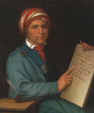
The Cherokee "living museum" founded by the Eastern Band of Cherokee in 1952, and is operated by the Cherokee Historical Association. [1] The Eastern Band of Cherokee also established other local attractions, including in 1948 with the Museum of the Cherokee Indian; and in 1950 with the Unto These Hills outdoor theater series. [1] Guides take visitors through the village explaining the history and culture of the Cherokee and also demonstrate the making of such items as arrowheads, baskets, and blowguns.
The Cherokee are one of the Indigenous peoples of the Southeastern Woodlands of the United States. Prior to the 18th century, they were concentrated in their homelands, in towns along river valleys of what is now southwestern North Carolina, southeastern Tennessee, southwestern Virginia, edges of western South Carolina, northern Georgia and northeastern Alabama.

Swain County is a county located on the far western border of the U.S. state of North Carolina. As of the 2020 census, the population was 14,117. Its county seat is Bryson City.

Great Smoky Mountains National Park is an American national park in the southeastern United States, with parts in North Carolina and Tennessee. The park straddles the ridgeline of the Great Smoky Mountains, part of the Blue Ridge Mountains, which are a division of the larger Appalachian Mountain chain. The park contains some of the highest mountains in eastern North America, including Clingmans Dome, Mount Guyot, and Mount Le Conte. The border between the two states runs northeast to southwest through the center of the park. The Appalachian Trail passes through the center of the park on its route from Georgia to Maine. With 14.1 million visitors in 2021, the Great Smoky Mountains National Park is the most visited national park in the United States.

Cherokee is a census-designated place (CDP) in Swain and Jackson counties in Western North Carolina, United States, within the Qualla Boundary land trust. Cherokee is located in the Oconaluftee River Valley around the intersection of U.S. Routes 19 and 441. As of the 2020 census, the CDP had a population of 2,195. It is the capital of the federally recognized Eastern Band of Cherokee Indians, one of three recognized Cherokee tribes and the only one in North Carolina.

The Qualla Boundary or The Qualla is territory held as a land trust by the United States government for the federally recognized Eastern Band of Cherokee Indians (EBCI), who reside in western North Carolina. The area is part of the large historic Cherokee territory in the Southeast, which extended into eastern Tennessee, western South Carolina, northern Georgia and Alabama. Currently, the largest contiguous portion of the Qualla lies in Haywood, Swain, and Jackson counties and is centered on the community of Cherokee, which serves as the tribal capital of the Eastern Band of Cherokee Indians. Smaller, non-contiguous parcels also lie in Graham and Cherokee counties, near the communities of Snowbird and Murphy, respectively.
The Eastern Band of Cherokee Indians (EBCI), is a federally recognized Indian tribe based in western North Carolina in the United States. They are descended from the small group of 800–1,000 Cherokee who remained in the Eastern United States after the U.S. military, under the Indian Removal Act, moved the other 15,000 Cherokee to west of the Mississippi River in the late 1830s, to Indian Territory. Those Cherokee remaining in the east were to give up tribal Cherokee citizenship and to assimilate. They became U.S. citizens.
Southwestern Community College is a public community college in Sylva, North Carolina. It is part of the North Carolina Community College System.

The Cherokee Heritage Center is a non-profit historical society and museum campus that seeks to preserve the historical and cultural artifacts, language, and traditional crafts of the Cherokee. The Heritage center also hosts the central genealogy database and genealogy research center for the Cherokee People. The Heritage Center is located on the site of the mid-19th century Cherokee Seminary building in Park Hill, Oklahoma, a suburb of Tahlequah, and was constructed near the old structure. It is a unit of the Cherokee National Historical Society and is sponsored by the Cherokee Nation, the United Keetoowah Band of Cherokee Indians, and other area tribes. The center was originally known as Tsa-La-Gi but is now known as the Cherokee Heritage Center.
The Cherokee Botanical Garden and Nature Trail is a botanical garden and nature trail located beside the Oconaluftee Indian Village, off U.S. Route 441 in Cherokee, North Carolina.

Kituwa or giduwa (Cherokee:ᎩᏚᏩ) is an ancient Native American settlement near the upper Tuckasegee River, and is claimed by the Cherokee people as their original town. An earthwork platform mound, built about 1000 CE, marks a ceremonial site here. The historic Cherokee built a townhouse on top that was used for their communal gatherings and decisionmaking; they replaced it repeatedly over decades. They identify Kituwa as one of the "seven mother towns" in their traditional homeland of the American Southeast. This site is in modern Swain County, North Carolina, in the Great Smoky Mountains.

Whiteside Mountain or Sanigilâ'gĭ in Cherokee is a mountain in Jackson County, North Carolina between Cashiers, Highlands, North Carolina, and the Georgia border. Whiteside Mountain can boast the highest cliffs in Eastern North America. It also has a feature called Devil's Courthouse, not to be confused with the Devil's Courthouse 20 miles away in Transylvania County, NC.

The Oconaluftee is the valley of the Oconaluftee River in the Great Smoky Mountains of North Carolina. Formerly the site of a Cherokee village and an Appalachian community, the valley is now North Carolina's main entrance to Great Smoky Mountains National Park.

Overhill Cherokee was the term for the Cherokee people located in their historic settlements in what is now the U.S. state of Tennessee in the Southeastern United States, on the western side of the Appalachian Mountains. This name was used by 18th-century European traders and explorers from British colonies along the Atlantic coast, as they had to cross the mountains to reach these settlements.

The Cherokee Nation was a legal, autonomous, tribal government in North America recognized from 1794 to 1907. It was often referred to simply as "The Nation" by its inhabitants. The government was effectively disbanded in 1907, after its land rights had been extinguished, prior to the admission of Oklahoma as a state. During the late 20th century, the Cherokee people reorganized, instituting a government with sovereign jurisdiction known as the Cherokee Nation. On July 9, 2020, the United States Supreme Court ruled that the Muscogee (Creek) Nation had never been disestablished in the years before allotment and Oklahoma Statehood.

Cherokee Preservation Foundation is an independent nonprofit foundation established in 2000 as part of the Tribal-State Compact amendment between the Eastern Band of Cherokee Indians (EBCI) and the State of North Carolina. The Foundation is funded by the EBCI from gaming revenues generated by the Tribe; it is not associated with any for-profit gaming entity and is a separately functioning organization independent of the Tribal government. It works to improve the quality of life of the EBCI and strengthen the western North Carolina region by balancing Cherokee ways with the pursuit of new opportunities.
Nununyi was a historic village of the Cherokee people in western North Carolina, located on the eastern side of the Oconaluftee River. Today it is within the boundaries of the present-day city of Cherokee in Swain County. It was classified by English traders and colonists as among the "Out Towns" of the Cherokee in this area east of the Appalachian Mountains.
Ravensford is an unincorporated community in Swain County, Western North Carolina. This is within the traditional homeland of the Cherokee people. In a survey and excavation project in the early 21st century, part of the community was found to have archeological resources that were thousands of years old, in addition to more recent historic materials related to the Cherokee people. In 1938, the US Government and state of North Carolina negotiated with the Eastern Band of Cherokee Indians to gain their agreement to transfer some of their land to enable construction of the Blue Ridge Parkway. In return, lands in Ravensford were transferred to their Qualla Boundary property.

Mingo Falls is a 120 ft (37 m) high waterfall located in the Qualla Boundary—a land trust of the Eastern Band of Cherokee Indians—near the town of Cherokee, Swain County, North Carolina in the Blue Ridge Mountains of the eastern United States. The waterfall is among the tallest in the southern Appalachians.
The Oconaluftee River drains the south-central Oconaluftee valley of the Great Smoky Mountains in Western North Carolina before emptying into the Tuckasegee River. The river flows through the Qualla Boundary, a federal land trust that serves as a reserve for the Eastern Band of the Cherokee, the only federally recognized tribe in North Carolina. They bought the land back from the federal government in the 1870s, after having been pushed off and forced to cede it earlier in the 19th century. Several historic Cherokee towns are known to have been located along this river.

The Museum of the Cherokee People (MTCP), formerly known as the Museum of the Cherokee Indian (MCI), is a 501(c)3 nonprofit cultural arts and history museum, educational center, and archive founded in 1948, and located in Cherokee, North Carolina. The museum provides permanent exhibitions, an artifact collection, workshops, educational programs, and a museum store. The museum was previously operated by the Cherokee Historical Association, but later became its own entity. It has been part of the North American Reciprocal Museum Association.
| International | |
|---|---|
| National | |
35°29′12″N83°19′22″W / 35.4867655°N 83.3226525°W
| | This North Carolina museum-related article is a stub. You can help Wikipedia by expanding it. |