Bradley County is a county located in the southeastern portion of the U.S. state of Tennessee. As of the 2020 census, the population was 108,620, making it the thirteenth most populous county in Tennessee. Its county seat is Cleveland. It is named for Colonel Edward Bradley of Shelby County, Tennessee, who was colonel of Hale's Regiment in the American Revolution and the 15th Regiment of the Tennessee Volunteers in the War of 1812. Bradley County is included in the Cleveland, Tennessee Metropolitan Statistical Area, which is also included in the Chattanooga-Cleveland-Dalton, TN-GA-AL Combined Statistical Area.

Walker County is a county located in the northwestern part of the U.S. state of Georgia. As of the 2020 census, the population was 67,654, down from 68,756 in 2010. The county seat is LaFayette. The county was created on December 18, 1833, from land formerly belonging to the Cherokee Indian Nation.

Murray County is a county located in the northwestern part of the U.S. state of Georgia. As of the 2020 census, the population was 39,973. The county seat is Chatsworth.

Chattanooga is a city in and the county seat of Hamilton County, Tennessee, United States. It is located along the Tennessee River, and borders Georgia to the south. With a population of 181,099 in 2020, it is Tennessee's fourth-largest city and one of the two principal cities of East Tennessee, along with Knoxville. It anchors the Chattanooga metropolitan area, Tennessee's fourth-largest metropolitan statistical area, as well as a larger three-state area that includes Southeast Tennessee, Northwest Georgia, and Northeast Alabama.

Braswell is a city in Polk and Paulding counties in the U.S. state of Georgia. As of the 2020 census, the city had a population of 355.

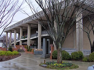
Cleveland is the county seat of and largest city in Bradley County, Tennessee. The population was 47,356 at the 2020 census. It is the principal city of the Cleveland metropolitan area, Tennessee, which is included in the Chattanooga–Cleveland–Dalton, TN–GA–AL Combined Statistical Area.

Elizabethton is a city in, and the county seat of Carter County, Tennessee, United States. Elizabethton is the historical site of the first independent American government located west of both the Eastern Continental Divide and the original Thirteen Colonies.

Lenoir City is a suburban city located in Loudon County, Tennessee. The population was 10,117 at the 2020 census. It is included in the Knoxville metropolitan area in East Tennessee, along the Tennessee River southwest of Knoxville.

Rockwood is a city in Roane County, Tennessee, United States. Its population was 5,562 at the time of the 2010 census. It is included in the Harriman, Tennessee Micropolitan Statistical Area.

East Tennessee is one of the three Grand Divisions of Tennessee defined in state law. Geographically and socioculturally distinct, it comprises approximately the eastern third of the U.S. state of Tennessee. East Tennessee consists of 33 counties, 30 located within the Eastern Time Zone and three counties in the Central Time Zone, namely Bledsoe, Cumberland, and Marion. East Tennessee is entirely located within the Appalachian Mountains, although the landforms range from densely forested 6,000-foot (1,800 m) mountains to broad river valleys. The region contains the major cities of Knoxville and Chattanooga, Tennessee's third and fourth largest cities, respectively, and the Tri-Cities, the state's sixth largest population center.

Lookout Mountain is a mountain ridge located at the northwest corner of the U.S. state of Georgia, the northeast corner of Alabama, and along the southeastern Tennessee state line in Chattanooga. Lookout Mountain was the scene of the 18th-century "Last Battle of the Cherokees" in this area during the Nickajack Expedition. On November 24, 1863, during the American Civil War, the Battle of Lookout Mountain took place here.

The Tennessee Valley Railroad Museum is a railroad museum and heritage railroad in Chattanooga, Tennessee.

Missionary Ridge is a geographic feature in Chattanooga, Tennessee, site of the Battle of Missionary Ridge, a battle in the American Civil War, fought on November 25, 1863. Union forces under Maj. Gens. Ulysses S. Grant, William T. Sherman, and George H. Thomas routed Confederate forces under General Braxton Bragg and lifted the siege of the city.

Bean Station is a town in Grainger and Hawkins of Tennessee, United States. As of the 2020 census, the population was 2,967. It is part of the Kingsport, Knoxville, and Morristown metropolitan statistical areas.

The St. Elmo Historic District, or St. Elmo for short, is a neighborhood in the city of Chattanooga, Tennessee. It is situated in the southernmost part of Hamilton County within the valley of Lookout Mountain below the part of the Tennessee River known as Moccasin Bend. St Elmo is at the crossroads of two ancient Indian trails, and was first occupied by Native American hunters and gatherers in the Woodland period, then agricultural Mississippians, including Euchee and Muscogee, and for a brief period between 1776 and 1786, the Cherokees in a community called Lookout Town. St. Elmo became part of the city of Chattanooga when it was annexed in September 1929.
Morganton was a community that developed on the Little Tennessee River in Loudon County, Tennessee, in the southeastern United States. It was located 13.7 miles (22.0 km) above the mouth of the river at its confluence with Bakers Creek, flowing westward from Maryville. During its heyday in the 19th century, Morganton thrived as a flatboat port and regional business center. An important ferry operated at Morganton for nearly 170 years providing service across the river. The abandoned townsite was submerged in the late 20th century by creation of Tellico Lake, part of the Tellico Dam hydroelectric project completed in 1979 by the Tennessee Valley Authority (TVA).

Wears Valley is an unincorporated community in Sevier County, Tennessee that was formerly treated by the U.S. Census Bureau as a census county division. As of the 2000 Census, the population of Wears Valley was 6,486.

Sherwood is an unincorporated community in Franklin County, Tennessee, United States. It is located along Tennessee State Route 56 13.1 miles (21.1 km) southeast of Winchester, and just north of the Alabama state line. Sherwood has a post office with ZIP code 37376.
The Copper Basin, also known as the Ducktown Basin, is a geological region located primarily in Polk County, Tennessee, that contains deposits of copper ore and covers approximately 60,000 acres. Located in the southeastern corner of Tennessee, small portions of the basin extend into Fannin County, Georgia, and Cherokee County, North Carolina. The basin is surrounded by the Cherokee National Forest, and the cities of Ducktown and Copperhill, Tennessee, and McCaysville, Georgia are located in the basin.

William Wierman Wright was a well known nineteenth century American railroad engineer and civil engineer. He was born in York Springs, Pennsylvania.


