Oconaluftee (Great Smoky Mountains)

Last updated

Oconaluftee Archeological District
Oconaluftee-river1.jpg
USA North Carolina location map.svg
Red pog.svg
Usa edcp location map.svg
Red pog.svg
Nearest city Cherokee, North Carolina
Coordinates 35°30′56″N83°18′19″W / 35.51556°N 83.30528°W / 35.51556; -83.30528
Area383 acres (155 ha)
NRHP reference No. 82001715 [1]
Added to NRHPFebruary 19, 1982
Oconaluftee Visitor Center near the eastern entrance to the park Oconaluftee Visitor Center, GSMNP IMG 4920.JPG
Oconaluftee Visitor Center near the eastern entrance to the park

The Oconaluftee is the valley of the Oconaluftee River in the Great Smoky Mountains of North Carolina. Formerly the site of a Cherokee village and an Appalachian community, the valley is now North Carolina's main entrance to Great Smoky Mountains National Park.

Contents

The Oconaluftee gradually broadens from Smokemont in the north to the southern tip of the Qualla Boundary. The Qualla Boundary, commonly referred to as Cherokee, North Carolina, comprises the bulk of a federal trust that serves as a reserve for the Eastern Band of Cherokee Indians.

The National Park Service lands in Oconaluftee are home to the Oconaluftee Visitor Center, Mingus Mill, and the Mountain Farm Museum. Much of the area is part of the Oconaluftee Archaeological District, which was listed on the National Register of Historic Places in 1982.

Description

Deep Creek Valley, part of the Oconaluftee watershed Newfound-deep-creek.jpg
Deep Creek Valley, part of the Oconaluftee watershed

Near Newfound Gap, several small streams converge to form Beech Flats Prong. This stream flows south along the southern base of Mount Kephart, dropping 2,000 feet (600 m) over 10 miles (16 km) before merging with Kephart Prong, Kanati Fork, and Smith Branch to form the Oconaluftee River. The Oconaluftee continues southward, cutting a valley between the Richland Mountain massif to the east and the Thomas Ridge massif to west. The confluence of the Oconaluftee River and Bradley Fork at Smokemont strengthens the river considerably.

Near the park boundary, a large and relatively flat bottomland has been created by the river's junction with Raven Fork, which flows down from the northeast. Past Cherokee, the river turns west en route to its mouth along the Tuckasegee River, near Bryson City.

Geology

The rock formation underlying the area around the Oconaluftee-Raven Fork junction contains some of the oldest exposed rocks in the Eastern United States. This formation, which is composed primarily of an Early Precambrian basement rock known as granite gneiss, was formed over a billion years ago from the gradual accumulation of marine sediment and igneous rocks. [2]

The upper elevations of the Oconaluftee Valley are underlain by a Late Precambrian metamorphic rock of the Ocoee Supergroup, which is the dominant rock class in the Great Smokies. These rocks were formed from ocean sediments nearly 400 million years ago, and were thrust upward during the Appalachian orogeny, when the North American and African plates collided. [3]

The Greenbrier Fault, which crosses the Oconaluftee River between Tow String Creek and Mingus Creek, divides the basement formation from the Late Precambrian formation. [4] Exposures of both rock formations can be seen along U.S. Route 441 between Newfound Gap and Cherokee. [5]

History

Early history

The Oconaluftee bottomlands, with Rattlesnake Mountain rising in the distance. Oconaluftee-raven-fork.jpg
The Oconaluftee bottomlands, with Rattlesnake Mountain rising in the distance.

The Cherokee considered the waters of the Oconaluftee sacred. Dora Woodruff Cope, who lived in the Oconaluftee valley near Smokemont around 1900, recalled a legend her Cherokee neighbors told her:

... part of the river was called Ya'nu-u'nata wasti'yi, "Where the bears wash." It was a deeper part of the river, where all the animals came to wash and heal their wounds when they had been hurt by hunters. No white person had ever seen this place because evil had blinded us to its existence. The animals knew how to find it, and diving into it meant instant healing. [6]

The term "Oconaluftee" comes from the Cherokee village name Egwanulti, which means "by the river." [7] It was recorded by naturalist John Bartram in his journals of 1775. [8] The location of the village was unknown, although early although anthropologist James Mooney believed it to be situated near modern Birdtown, between Cherokee and Bryson City. [8]

An archaeological survey and its evidence, however, has identified a Cherokee settlement along the Oconaluftee north of the Qualla Boundary and just inside the present-day national park. While the Cherokee ranged widely over the Smokies, this is the only known permanent Cherokee settlement within the park boundaries. [9] This village was likely destroyed in 1776 by the army of General Griffith Rutherford during the American Revolution. [10]

19th century

Enloe Barn at the Oconaluftee Mountain Farm Museum Oconaluftee-enloe-barn.jpg
Enloe Barn at the Oconaluftee Mountain Farm Museum
Messer's Applehouse; apples, a staple crop in the area, were eaten raw or converted into apple butter or apple cider. Oconaluftee-applehouse-messer1.jpg
Messer's Applehouse; apples, a staple crop in the area, were eaten raw or converted into apple butter or apple cider.
19th century fence at Mountain Farm Museum Fences at Mountain Farm Museum, GSMNP IMG 4916.JPG
19th century fence at Mountain Farm Museum
Meat storage house, used mostly for pork, at the Mountain Farm Museum Meat house at Mountain Farm Museum, GSMNP IMG 4909.JPG
Meat storage house, used mostly for pork, at the Mountain Farm Museum

John Jacob Mingus, who arrived in the Oconaluftee in the 1790s, was the first Euro-American settler in the valley and the first within the boundaries of what is now the Great Smoky Mountains National Park. [11] Mingus purchased the land from Felix Walker, a land speculator and later North Carolina congressman. While Mingus roamed from county to county in the Southern Appalachians, his descendants would remain in the area until the establishment of the park.

Mingus was followed by Abraham Enloe, who settled downstream from the Mingus plot. Enloe's resembled Abraham Lincoln, and many locals believed he was the president's father. [6] Later Euro-American arrivals included Isaac Bradley (1772–1855), whose family settled in the vicinity of the stream that now bears their name, and Aden Carver (1844–1945), who lived near Smokemont.

In 1831, Enloe entered into a partnership with William Holland Thomas to form the Oconaluftee Turnpike Company. The company widened the Indian Gap Trail from Oconaluftee to the crest of the Smokies, allowing wagon access to saltpeter mines on Mount Le Conte. The road's first tollkeeper, Robert Collins, would later guide Arnold Guyot on surveying expeditions across the crest of the Smokies. Mount Collins, between Clingmans Dome and Newfound Gap, is named for him. [12]

Thomas, the son of caucasian parents who was adopted by Cherokee peace chief Yonaguska, took control of Cherokee business affairs in the 1830s. His land purchases for the tribe included the Qualla Boundary, which became the backbone of the federal trust for the Eastern Band of the Cherokee. After the 1835 Treaty of New Echota ordered the Cherokees' removal from all eastern lands, Thomas went to Washington and successfully argued that since the Oconaluftee Cherokees were North Carolina citizens, the treaty did not apply to them. In 1868, the Eastern Band was recognized as a separate tribe. [13]

20th century

In the late 19th-century, innovations in the band saw and logging railroad led to a logging boom in Southern Appalachia. With base camps at Smokemont, the Three M Lumber Company and later the Champion Fibre Company cut much of the Oconaluftee valley before its tract was bought out by the Great Smoky Mountains Park Commission in the 1930s. In 1925, a massive forest fire quickly swept across the dried brush left over from the extensive logging, scorching much of the southern slopes of the Smokies. [14]

After the establishment of the national park, a Civilian Conservation Corps (CCC) camp was set up at Smokemont for workers to construct roads and trails in the area. In 1937, the CCC restored Mingus Mill, a large turbine-driven gristmill on Mingus Creek. In the 1950s, several log structures were moved to an area adjacent to the Oconaluftee Visitor Center to form the Mountain Farm Museum, which provides an exhibition of pioneer European-American life in Appalachia.

Present day

Bradley Fork at Smokemont Bradley-fork-smokemont.jpg
Bradley Fork at Smokemont
Mountain Farm Museum Oconaluftee-mountain-farm-museum1.jpg
Mountain Farm Museum
The John Davis Cabin John-davis-cabin1.jpg
The John Davis Cabin
Students on field trip at the John Davis Cabin (July 2012) Homestead at Mountain Farm Museum, GSMNP IMG 4917.JPG
Students on field trip at the John Davis Cabin (July 2012)

Along with the historic sites in the vicinity of the Oconaluftee Visitor Center, the park service maintains a large campground at the former logging camp of Smokemont. The small mountain hamlet of Tow String is sandwiched between the national park and Qualla Boundary, just above Oconaluftee. The southern terminus of the Blue Ridge Parkway is at the valley's southern tip, near the river's confluence with Raven Fork.

A 20-mile (32 km) leg of the Mountains-to-Sea Trail connects Oconaluftee with the Appalachian Trail near the summit of Clingmans Dome. The Bradley Fork Trail follows Bradley Fork north from Smokemont to the Cabin Flats area between Hughes Ridge and Richland Mountain. From here, the Dry Sluice Gap Trail continues north to the crest of the Smokies, emerging near Charlies Bunion.

In 1982, the Oconaluftee area was added to the National Register of Historic Places as the Oconaluftee Archaeological District.

Mingus Mill

Mingus Mill was built in 1886 by the millwright Sion Thomas Early of Sevier County, Tennessee. Early did the work for John Mingus, a son of John Jacob Mingus. Early completed the mill in three months for a cost of $600. The mill operated at wholesale and retail levels until the National Park Service purchased the property in 1934. The mill was restored in 1937, closed during World War II, and reopened in 1968.

Water diverted from Mingus Creek via a sluice, and a wooden flume turns two turbines which provide power to the mill. An iron shaft connects the turbines to grindstones on the first floor and a wheat cleaner and bolting chest on the second floor (the latter two via a series of pulleys). Wheat or corn is first transported by bucket belt to the wheat cleaner, which is essentially a fan which clears the grain of dirt and excess material, and then drops it back to the first floor. The cleaned grain is then fed into the grindstones, which break it down into flour (or cornmeal). The flour is then transported back to the second floor and fed into the bolting chest, which uses bolts of progressively coarser cloth to separate the flour into different grades.

While the mill's turbine is not as photogenic as the overshot wheels that power mills such as the Cable Mill at Cades Cove, it was more efficient and required less water power to operate. The turbine generated approximately 11 horsepower (8.2 kW) turning at 400 rpm.

Aden Carver, who arrived in Oconaluftee in the mid-19th century, helped Early build the mill in 1886. When the mill was restored in 1937, Carver, then in his 90s, aided in its restoration. [15]

Oconaluftee Visitor Center

The original visitor center at Oconaluftee was built in 1940 by the CCC as a ranger station and magistrate's courtroom. The stone-and-log cabin was designated a "temporary" visitor center in 1947, and stayed that way until 2011, when a new center was built in just two months in late winter and early spring, and dedicated on April 15. [16] The Great Smoky Mountains Association paid three million dollars for the buildings (the other being a highly efficient restroom facility between it and the original center), and Friends of the Smokies donated over half a million more for the exhibits inside. Trotter & Associates Architects, LLC was the architect of record for the new visitor center. No government or taxpayer money was allocated for the project, so construction costs had to come entirely from donations to the two groups, which in turn donated the center to the National Park Service. The center and restrooms are open year-round, and after 64 years of "temporary" use, the original building has finally been reverted to its original administrative use, though its rustic "parkitecture" remains untouched on the outside.

Mountain Farm Museum

Adjacent to the Oconaluftee Visitor Center is the Mountain Farm Museum. The museum is a collection of several log buildings from various places around the park, the purpose of which is to depict a typical mountain farm in pioneer Appalachia. Gardens are planted during the spring and summer, and barn fowl roam the premises. Since most of the structures were not moved from their original locations intact, they are not eligible for inclusion in the National Register of Historic Places. The park service maintains them by the same standards, however.

Structures at the Mountain Farm Museum include: [17]

Other buildings include a hog pen, a sorghum press and still (used to draw sorghum from cane and boil it into syrup), an ash hopper (water was filtered through the ashes to extract its lye, which was then mixed with hog lard to make soap), a woodshed, and native fencing.

Oconaluftee Indian Village

The Oconaluftee Indian Village is operated by the Cherokee Historical Association on the slopes of Rattlesnake Mountain inside the reserve. The outdoor museum is a replica of a typical Cherokee village from the mid-18th century.

Related Research Articles

<span class="mw-page-title-main">Swain County, North Carolina</span> County in North Carolina, United States

Swain County is a county located on the far western border of the U.S. state of North Carolina. As of the 2020 census, the population was 14,117. Its county seat is Bryson City.

<span class="mw-page-title-main">Gatlinburg, Tennessee</span> City in Tennessee, United States

Gatlinburg is a mountain resort city in Sevier County, Tennessee. It is located 39 miles (63 km) southeast of Knoxville and had a population of 3,944 at the 2010 Census and a U.S. Census population of 3,577 in 2020. It is a popular vacation resort, as it rests on the border of Great Smoky Mountains National Park along U.S. Route 441, which connects to Cherokee, North Carolina, on the southeast side of the national park. Prior to incorporation, the town was known as White Oak Flats, or simply White Oak.

<span class="mw-page-title-main">Pigeon Forge, Tennessee</span> City in Tennessee, United States

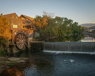
Pigeon Forge is a mountain resort city in Sevier County, Tennessee, United States. As of the 2020 census, the city had a total population of 6,343. Situated just 5 miles (8 km) north of Great Smoky Mountains National Park, Pigeon Forge is a tourist destination that caters primarily to Southern culture and country music fans. The city's attractions include Dollywood and Dollywood's Splash Country as well as numerous gift shops, outlet malls, amusement rides, and musical theaters.

<span class="mw-page-title-main">Great Smoky Mountains National Park</span> National park in Tennessee and North Carolina

Great Smoky Mountains National Park is an American national park in the southeastern United States, with parts in North Carolina and Tennessee. The park straddles the ridgeline of the Great Smoky Mountains, part of the Blue Ridge Mountains, which are a division of the larger Appalachian Mountain chain. The park contains some of the highest mountains in eastern North America, including Clingmans Dome, Mount Guyot, and Mount Le Conte. The border between the two states runs northeast to southwest through the center of the park. The Appalachian Trail passes through the center of the park on its route from Georgia to Maine. With 14.1 million visitors in 2021, the Great Smoky Mountains National Park is the most visited national park in the United States.

<span class="mw-page-title-main">Great Smoky Mountains</span> American mountain range along North Carolina/Tennessee border

The Great Smoky Mountains are a mountain range rising along the Tennessee–North Carolina border in the southeastern United States. They are a subrange of the Appalachian Mountains and form part of the Blue Ridge Physiographic Province. The range is sometimes called the Smoky Mountains, and the name is commonly shortened to the Smokies. The Smokies are best known as the home of the Great Smoky Mountains National Park, which protects most of the range. The park was established in 1934 and, with over 11 million visits per year, is the most visited national park in the United States.

<span class="mw-page-title-main">Cherokee, North Carolina</span> Census-designated place in North Carolina, United States

Cherokee is a census-designated place (CDP) in Swain and Jackson counties in Western North Carolina, United States, within the Qualla Boundary land trust. Cherokee is located in the Oconaluftee River Valley around the intersection of U.S. Routes 19 and 441. As of the 2020 census, the CDP had a population of 2,195. It is the capital of the federally recognized Eastern Band of Cherokee Indians, one of three recognized Cherokee tribes and the only one in North Carolina.

<span class="mw-page-title-main">Chimney Tops</span> Mountain in Tennessee, US

Chimney Tops is a mountain in the central Great Smoky Mountains in Tennessee. It is 4,724 feet (1,440 m) above sea level. Chimney Tops is a double-capstone knob on the eastern slope of the Sugarland Mountain massif, which stretches north-south across the north-central section of the Smokies. Mount Le Conte resides east of Chimney Tops and Mt. Mingus southeast of Chimney Tops. Thus, while the view from the summit is 360 degrees, Chimney Tops is practically "walled in" on three sides.

<span class="mw-page-title-main">The Sugarlands</span> Valley in the north-central Great Smoky Mountains

The Sugarlands is a valley in Tennessee within the north-central Great Smoky Mountains, located in the southeastern United States. Formerly home to a string of small Appalachian communities, the valley is now the location of the Great Smoky Mountains National Park headquarters and the Sugarlands Visitor Center. Lying just south of Gatlinburg, the Sugarlands is one of the park's most popular access points.

<span class="mw-page-title-main">Roaring Fork (Great Smoky Mountains)</span> Stream in Tennessee

Roaring Fork is a stream in the Great Smoky Mountains of Tennessee, located in the southeastern United States. Once the site of a small Appalachian community, today the stream's area is home to the Roaring Fork Motor Nature Trail and the Roaring Fork Historic District.

<span class="mw-page-title-main">Charlies Bunion</span> Mountain in the eastern United States

Charlies Bunion is a mountain in the Great Smoky Mountains of the Southeastern United States, characterized by a large boulder-like protrusion just below the summit on its otherwise-sheer northern face. The mountain is a rare instance of a bare-rock summit in the Smokies.

<span class="mw-page-title-main">Greenbrier (Great Smoky Mountains)</span> Valley in Sevier County, Tennessee

Greenbrier is a valley in the northern Great Smoky Mountains of Tennessee, located in the southeastern United States. Now a recreational area located within the Great Smoky Mountains National Park, Greenbrier was once home to several Appalachian communities.

<span class="mw-page-title-main">Cataloochee (Great Smoky Mountains)</span> Valley in North Carolina, United States

Cataloochee is a valley in the Great Smoky Mountains of North Carolina, located in the Southeastern United States. Now a recreational and historic area within the Great Smoky Mountains National Park, Cataloochee was once home to a substantial Appalachian community and Cherokee hunting ground.

<span class="mw-page-title-main">Hazel Creek (Great Smoky Mountains)</span> River in North Carolina, United States

Hazel Creek is a tributary stream of the Little Tennessee River in the southwestern Great Smoky Mountains of North Carolina. The creek's bottomlands were home to several pioneer Appalachian communities and logging towns before its incorporation into the Great Smoky Mountains National Park. Hazel Creek is now a back country campsite and historical area.

<span class="mw-page-title-main">Sugarland Mountain Trail</span>

The Sugarland Mountain Trail is an American hiking trail, in the Great Smoky Mountains National Park of Sevier County, Tennessee. The trail traverses Sugarland Mountain, a massive ridge running perpendicular to the main crest of the Smokies and effectively dividing the park's north-central section from its northwestern section. Sugarland Mountain is flanked by the deep upper valleys of two of the park's major watersheds— the West Fork of the Little Pigeon River and Little River. The trail passes through several forest types, including deciduous forest at lower elevations, heaths ("hells") along the mountain's backbone formations, and a stand of Southern Appalachian spruce-fir forest in the upper elevations. Occasional breaks in the foliage allow for views of Mount Le Conte and Sevier County to the east and Blanket Mountain and the ridges above Elkmont to the west.

<span class="mw-page-title-main">Marks Knob</span>

Marks Knob is a mountain in the Great Smoky Mountains, in the southeastern United States. It has an elevation of 6,169 feet (1,880 m), with 249 feet (76 m) of clean prominence. Its summit— located near the center of the Eastern Smokies amidst a dense stand of Southern Appalachian spruce-fir forest— is a popular bushwhacking destination and one of the most difficult-to-reach summits of the Southern Sixers.

<span class="mw-page-title-main">Noah Ogle Place</span> Historic house in Tennessee, United States

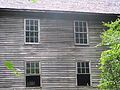
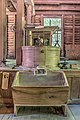
The Noah "Bud" Ogle Place was a homestead located in the Great Smoky Mountains of Sevier County, in the U.S. state of Tennessee. The homestead presently consists of a cabin, barn, and tub mill built by mountain farmer Noah "Bud" Ogle (1863–1913) in the late 19th century. In 1977, the homestead was added to the National Register of Historic Places and is currently maintained by the Great Smoky Mountains National Park.

<span class="mw-page-title-main">Walker Sisters Place</span> Historic house in Tennessee, United States

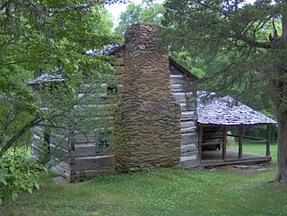
The Walker Sisters Place was a homestead in the Great Smoky Mountains of Sevier County, in the U.S. state of Tennessee. The surviving structures—which include the cabin, springhouse, and corn crib—were once part of a farm that belonged to the Walker sisters—five sisters who became local legends because of their adherence to traditional ways of living. The sisters inherited the farm from their father, and after the Great Smoky Mountains National Park was formed in the 1930s, they obtained a lifetime lease. The National Park Service gained control of the property in 1964 when the last Walker sister died. The surviving structures were placed on the National Register of Historic Places in 1976.

<span class="mw-page-title-main">Mingo Falls</span> Waterfall

Mingo Falls is a 120 ft (37 m) high waterfall located in the Qualla Boundary—a land trust of the Eastern Band of Cherokee Indians—near the town of Cherokee, Swain County, North Carolina in the Blue Ridge Mountains of the eastern United States. The waterfall is among the tallest in the southern Appalachians.

<span class="mw-page-title-main">Oconaluftee River</span> River in the eastern United States

The Oconaluftee River drains the south-central Oconaluftee valley of the Great Smoky Mountains in Western North Carolina before emptying into the Tuckasegee River. The river flows through the Qualla Boundary, a federal land trust that serves as a reserve for the Eastern Band of the Cherokee, the only federally recognized tribe in North Carolina. They bought the land back from the federal government in the 1870s, after having been pushed off and forced to cede it earlier in the 19th century. Several historic Cherokee towns are known to have been located along this river.

<span class="mw-page-title-main">Ravensford Site</span>

The Ravensford Site is an old archaeological site located in the state of North Carolina, specifically within modern-day Swain County of the Appalachian Summit Region. Slightly north of the town of Cherokee, it sits at the edge of Oconaluftee River along the Raven Fork tributary on the Qualla Boundary. Its current elevation is 2,012 feet.

References

  1. "National Register Information System". National Register of Historic Places . National Park Service. July 9, 2010.
  2. Harry Moore, A Roadside Guide to the Geology of the Great Smoky Mountains National Park (Knoxville: University of Tennessee Press, 1988), 45, 101.
  3. Harry Moore, A Roadside Guide to the Geology of the Great Smoky Mountains National Park (Knoxville: University of Tennessee Press, 1988), 23–27.
  4. Harry Moore, A Roadside Guide to the Geology of the Great Smoky Mountains National Park (Knoxville: University of Tennessee Press, 1988), 32.
  5. Harry Moore, A Roadside Guide to the Geology of the Great Smoky Mountains National Park (Knoxville: University of Tennessee Press, 1988), 98–101.
  6. 1 2 Florence Cope Bush, Dorie: Woman of the Mountains (Knoxville: University of Tennessee Press, 1992), . 18.
  7. Bright, William (2004). Native American placenames of the United States. University of Oklahoma Press. p. 343. ISBN   978-0-8061-3598-4 . Retrieved November 18, 2011.
  8. 1 2 James Mooney, Myths of the Cherokee and Sacred Formulas of the Cherokee (Nashville: Charles Elder, 1972), 517.
  9. Carson Brewer, Great Smoky Mountains National Park (Portland, Ore: Graphic Arts Center Publishing, 1993), 18.
  10. James Mooney, Myths of the Cherokee and Sacred Formulas of the Cherokee (Nashville: Charles Elder, 1972), 49.
  11. Daniel Pierce, The Great Smokies: From Natural Habitat to National Park (Knoxville: University of Tennessee Press, 2000), 9.
  12. Michael Frome, Strangers In High Places: The Story of the Great Smoky Mountains (Knoxville: University of Tennessee Press, 1994), 107.
  13. Vicki Rozema, Footsteps of the Cherokees (Winston-Salem: John F. Blair Publisher, 1995), 58–60.
  14. Michal Strutin, History Hikes of the Smokies (Gatlinburg, Tennessee: Great Smoky Mountains Association, 2003), 125, 325.
  15. Information in this section obtained from interpretive signs provided by the National Park Service at the Mingus Mill site, July 2007.
  16. "Great Smoky Mountains National Park - Oconaluftee Visitor Center Officially Dedicated (U.S. National Park Service)". Archived from the original on June 27, 2011.
  17. Unless otherwise noted, information in this section obtained from: Tom Robbins, Mountain Farm Museum Self-Guided Tour (Gatlinburg: Great Smoky Mountains Association, date not given).
  18. Ed Trout, Historic Buildings of the Smokies (Gatlinburg: Great Smoky Mountains Association, 1995), 12.
  19. George Ellison, "Mountain Farm Museum Celebrates 50th Anniversary Archived November 13, 2006, at the Wayback Machine ." Smoky Mountain News, 21 May 2003. Retrieved: 18 August 2007.
  20. Ed Trout, Historic Buildings of the Smokies (Gatlinburg: Great Smoky Mountains Association, 1995), 47.
  21. Michal Strutin, History Hikes of the Smokies (Gatlinburg: Great Smoky Mountains Association, 2003), 264–266.