Related Research Articles

The Granite Mountains are a short subrange of the Rocky Mountains in central Wyoming of the United States. The range runs approximately 100 mi (160 km) E-W along the south side of the Shoshone Basin, and north of the Sweetwater River, in eastern Fremont County and western Natrona County. The highest point is McIntosh Peak at 8,058 feet (2,456 m). Independence Rock is at the east end of the range, and Split Rock was a prominent landmark on the Oregon Trail. The region is rich in uranium and other mineral deposits.
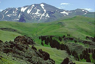
Francs Peak is the highest point in the Absaroka Range which extends from north central Wyoming into south central Montana, in the United States. It is in the Washakie Wilderness of Shoshone National Forest, and the peak is also the highest point in Park County, Wyoming, which includes much of Yellowstone National Park. It was named after Otto Franc, a cattle baron and homesteader in the Big Horn Basin.

Rolling Thunder Mountain is in the northern Teton Range, Grand Teton National Park, Wyoming. The peak is located northwest of Moran Bay on Jackson Lake and access to the peak involves navigating through several miles of backcountry areas of Snowshoe Canyon where there are no maintained trails.

Eagles Rest Peak is in the northern Teton Range, Grand Teton National Park, Wyoming. The peak is located west of and across Jackson Lake from Colter Bay Village. The peak rises dramatically almost 4,500 feet (1,400 m) above Jackson Lake in less than 1 mile (1.6 km). Waterfalls Canyon is to the north of the peak and Snowshoe Canyon lies to the south.
Traverse Peak is in the northern Teton Range, Grand Teton National Park, Wyoming. The mountain rises abruptly above Moran Canyon to the south and the south fork of Snowshoe Canyon to the north. From Moran Bay on Jackson Lake, the south slopes of the mountain can be seen behind Bivouac Peak rising above Moran Canyon.
Wyoming Peak is the tallest mountain in the Wyoming Range in the U.S. state of Wyoming. Situated in Bridger-Teton National Forest, a now collapsed fire lookout is located on the summit. Wyoming Peak is .75 miles (1.21 km) south-southeast of Coffin Peak, the second highest peak in the Wyoming Range.
Doubletop Peak is a mountain in the state of Wyoming. The peak is the tallest in the Gros Ventre Range. Doubletop Peak is within the Gros Ventre Wilderness region of Bridger-Teton National Forest.
Rendezvous Peak is in the Teton Range in the U.S. state of Wyoming. Situated just south of Grand Teton National Park and within Bridger-Teton National Forest, Rendezvous Peak is the highest point on Rendezvous Mountain.
Survey Peak is located in the northern Teton Range in the U.S. state of Wyoming. The peak is on the border of Grand Teton National Park and the Jedediah Smith Wilderness of Caribou-Targhee National Forest. Survey Peak rises to the immediate north of Berry Creek and can be accessed via the Berry Creek Trail.
Red Mountain is located in the northern Teton Range in the U.S. state of Wyoming. The peak is on the border of Grand Teton National Park and the Jedediah Smith Wilderness of Caribou-Targhee National Forest.
Window Peak is located in the Teton Range, Grand Teton National Park in the U.S. state of Wyoming. The peak is in the western reaches of Moran Canyon.
Cleaver Peak (11,060 feet is located in the Teton Range, Grand Teton National Park in the U.S. state of Wyoming. Cleaver Peak is .64 miles to the NNE of Maidenform Peak. Cirque Lake is immediately east of the peak.
Littles Peak (10,717 feet is located in the Teton Range in the U.S. state of Wyoming. The peak is on the border of Grand Teton National Park and the Jedediah Smith Wilderness of Caribou-Targhee National Forest. Littles Peak is at the western end of Leigh Canyon.
Maidenform Peak (11,142 feet is located in the Teton Range, Grand Teton National Park in the U.S. state of Wyoming. Maidenform Peak is at the head of Leigh Canyon and .64 miles SSW of Cleaver Peak. Cirque Lake is immediately east of the peak.
Shadow Peak is located in the Teton Range, within Grand Teton National Park, U.S. state of Wyoming. Shadow Peak is just southeast of Nez Perce Peak and rises to the north above Avalanche Canyon.
Veiled Peak is located in the Teton Range, within Grand Teton National Park, U.S. state of Wyoming. Veiled Peak is west of Mount Wister and rises to the south above Snowdrift Lake.
Spearhead Peak is located in the Teton Range, Caribou-Targhee National Forest in the U.S. state of Wyoming. The peak is situated near the head of Death Canyon and the Teton Crest Trail is immediately west of the peak.
Bighorn Peak is located in the Bighorn Mountains in the U.S. state of Wyoming. The peak is the seventh highest in the range and it is in the Cloud Peak Wilderness of Bighorn National Forest. Bighorn Peak is 1.5 miles (2.4 km) south of Darton Peak.
Darton Peak is located in the Bighorn Mountains in the U.S. state of Wyoming. The peak is the eighth-highest in the range and it is in the Cloud Peak Wilderness of Bighorn National Forest. Darton Peak is 1.5 miles (2.4 km) north of Bighorn Peak and 4.5 mi (7.2 km) southeast of Mather Peaks.
Mather Peaks is located in the Bighorn Mountains in the U.S. state of Wyoming. The peak is the sixth highest in the range and it is in the Cloud Peak Wilderness of Bighorn National Forest. Mather Peaks is 4.5 miles (7.2 km) northwest of Darton Peak and 3.2 mi (5.1 km) south of Bomber Mountain.
References
- "Garfield Peak, Wyoming". Peakbagger.com. Retrieved 2006-10-12.
- "Garfield Peak, USGS Garfield Peak (WY) Topo Map". TopoQuest. Retrieved 2008-06-29.
- "Garfield Peak". Geographic Names Information System . United States Geological Survey.
| | This article about a location in Wyoming is a stub. You can help Wikipedia by expanding it. |