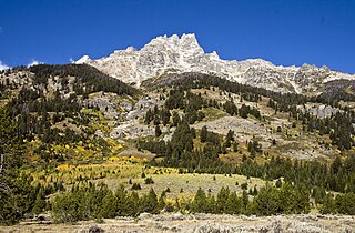
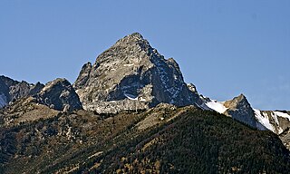
Mount Owen is the second highest peak in the Teton Range, Grand Teton National Park in the U.S. state of Wyoming. The peak is named after William O. Owen, who organized the first documented ascent of the Grand Teton in 1898. Mount Owen is part of the Cathedral Group of high Teton peaks, a collection of peaks in the central section of the range that are particularly rugged. The 40-mile (64 km) long Teton Range is the youngest mountain chain in the Rocky Mountains, and began its uplift 9 million years ago, during the Miocene. Several periods of glaciation have carved Mount Owen and the other peaks of the range into their current shapes. Valhalla Canyon is situated on the west slopes of Mount Owen.

Middle Teton is the third highest peak in the Teton Range, Grand Teton National Park, Wyoming. The peak is immediately southwest of Grand Teton and the two are separated from one another by the lower saddle, a broad high ridge at 11,600 feet (3,540 m). The Middle Teton Glacier is located on the eastern slopes of the peak. Middle Teton is a classic pyramidal shaped alpine peak and is sometimes included as part of the Cathedral Group of high Teton peaks. The 40-mile (64 km) long Teton Range is the youngest mountain chain in the Rocky Mountains, and began their uplift 9 million years ago, during the Miocene. Several periods of glaciation have carved Middle Teton and the other peaks of the range into their current shapes. From the lower saddle, a distinctive feature known as the black dike appears as a straight line running from near the top of the mountain down 800 feet (240 m). The black dike is a basaltic intrusion that occurred long after the surrounding rock was formed.
Teewinot Mountain is the sixth highest peak in the Teton Range, Grand Teton National Park, Wyoming. The name of the mountain is derived from the Shoshone Native American word meaning "many pinnacles". The peak is northeast of the Grand Teton, and the two are separated from one another by the Teton Glacier and Mount Owen. Teewinot Mountain rises more than 5,500 feet (1,700 m) above Jenny Lake. The 40 miles (64 km) long Teton Range is the youngest mountain chain in the Rocky Mountains, and began their uplift 9 million years ago, during the Miocene. Several periods of glaciation have carved Teewinot Mountain and the other peaks of the range into their current shapes. Broken Falls is one of the tallest cascades in Grand Teton National Park and descends 300 feet (91 m) down the eastern slopes of Teewinot Mountain.

South Teton is the fifth-highest peak in the Teton Range, Grand Teton National Park, in the U.S. state of Wyoming. The peak is south of Middle Teton and just west of Cloudveil Dome and is part of the Cathedral Group of high Teton peaks. The 40-mile-long (64 km) Teton Range is the youngest mountain chain in the Rocky Mountains, and began their uplift 9 million years ago, during the Miocene. Several periods of glaciation have carved South Teton and the other peaks of the range into their current shapes.

Signal Mountain is an isolated summit standing 7,720 feet (2,350 m) above sea level. The mountain is located in Grand Teton National Park in the U.S. state of Wyoming. The next closest higher summit is more than 10 miles (16 km) distant, and this isolation provides sweeping views of the Teton Range, much of the northern Jackson Hole area as well as the Snake River. Though located adjacent to the Tetons, Signal Mountain was not formed in the same manner or period. The mountain originally was formed by volcanic ashfall from one of the eruptions of the Yellowstone hotspot. The peak is also partially a glacial moraine formed by a receding glacier that came south out of the Yellowstone icecap. This same glacier also created neighboring Jackson Lake.

Ranger Peak is in the northern Teton Range, Grand Teton National Park, Wyoming. The peak is located slightly northwest of and across Jackson Lake from Colter Bay Village. Colter Canyon is to the north while Waterfalls Canyon is immediately southeast of the peak, but there are no maintained trails in the area. Access to the summit involves off trail hiking and scrambling. The top of the mountain is more than 4,500 feet (1,400 m) above Jackson Lake.

Doane Peak is in the northern Teton Range, Grand Teton National Park, Wyoming. The peak is located west of and across Jackson Lake from Colter Bay Village. The scenic Waterfalls Canyon is immediately northeast of the peak, but there are no maintained trails in the area. Access to the summit involves off trail hiking and scrambling as the top of the mountain is more than 4,500 feet (1,400 m) above Jackson Lake. The peak is named for Lt. Gustavus Cheyney Doane.

Eagles Rest Peak is in the northern Teton Range, Grand Teton National Park, Wyoming. The peak is located west of and across Jackson Lake from Colter Bay Village. The peak rises dramatically almost 4,500 feet (1,400 m) above Jackson Lake in less than 1 mile (1.6 km). Waterfalls Canyon is to the north of the peak and Snowshoe Canyon lies to the south.

Bivouac Peak is in the northern Teton Range, Grand Teton National Park, Wyoming. The peak is located immediately to the west of Moran Bay on Jackson Lake, and rises more than 4,000 ft (1,200 m) in less than 0.5 mi (0.80 km) from the lakeshore. Moran Canyon is situated to the south of the mountain and Snowshoe Canyon lies to the north.
Raynolds Peak is in the northern Teton Range, Grand Teton National Park, Wyoming. The mountain rises to the north of Moran Canyon and has numerous deep cirques on its north face above Snowshoe Canyon. There are no maintained trails in the region and the summit is 5 miles (8 km) west of Moran Bay on Jackson Lake. The peak is named after William F. Raynolds who was in charge of the 1859-1860 Raynolds Expedition to the region.

Thor Peak is in the northern Teton Range, Grand Teton National Park, in the U.S. state of Wyoming. Mount Moran is 1 mile (1.6 km) to the east. The summit is the eighth-highest in the Teton Range. Several semi-permanent snowfields as well as the Triple Glaciers are located on the east and northern slopes of the mountain. While the easiest route up the mountain, the south slope, is only rated a class 4, the mountain's remoteness and difficulty of approach make it a challenging mountain to summit.

Rockchuck Peak is located in the Teton Range, Grand Teton National Park in the U.S. state of Wyoming. The mountain is immediately west of String Lake and south of Paintbrush Canyon. The summit is .5 miles (0.80 km) north of Mount Saint John.

Mount Saint John, height 11,435 feet (3,485 m), is located in the Teton Range, Grand Teton National Park, Wyoming, northwest of Jenny Lake. The mountain towers above the northwest shore of Jenny Lake, and along with Symmetry Spire and Rockchuck Peak, form a massif which looms to the north above Cascade Canyon. The scenic Lake of the Crags, a cirque lake or tarn, is located immediately south of the summit and is accessed by way of Hanging Canyon.
Teepe Pillar is located in the Teton Range, Grand Teton National Park, Wyoming, immediately south of Grand Teton. The peak is the seventh highest in the Teton Range. Teepe Pillar is separated from Grand Teton by a col which drops sharply to the east and west. Northeast of and well below the summit, the Teepe Glacier is situated in a cirque. From Jackson Hole, Teepe Pillar is difficult to observe except from the northeast as it is hidden from view by Disappointment Peak.

Disappointment Peak is in the Teton Range of Wyoming, in Grand Teton National Park and immediately southeast of Grand Teton. The peak is part of the Cathedral Group, a region of the Tetons noted for particularly rugged mountains. Disappointment Peak rises to the north of Garnet Canyon and to the west of Amphitheater and Surprise lakes. The peak has a variety of mountaineering routes, including the most difficult in the range.
Cloudveil Dome is located in the Teton Range, Grand Teton National Park, Wyoming, immediately southeast of Grand Teton. The peak is in the central portions of the range, immediately east of South Teton and is sometimes considered to be part of what is collectively known as the Cathedral Group. Cloudveil Dome rises to the south of Garnet Canyon. The peak has a variety of mountaineering routes but since it is near to more popular climbing zones, it is often overlooked.

Nez Perce Peak is located in the Teton Range, Grand Teton National Park, Wyoming, immediately southeast of Grand Teton. The peak is in the central portions of the range, immediately east of Cloudveil Dome and is sometimes considered to be part of what is collectively known as the Cathedral Group. Nez Perce rises to the south of Garnet Canyon and is a dramatic peak that dominates the skyline to the west of Bradley and Taggart Lakes. When viewed from the western section of Jackson Hole, Nez Perce often obscures the view of Cloudveil Dome as well as South Teton, even though both summits are higher.
Buck Mountain 11,943 feet (3,640 m) is located in the Teton Range, Grand Teton National Park, Wyoming, immediately southeast of Grand Teton. The mountain is the highest summit south of Garnet Canyon and is easily seen from most vantage points in Jackson Hole. Views from the summit offer excellent views of the Cathedral Group to the north. The west slope of the summit tower are along the Alaska Basin Trail and extend into Caribou-Targhee National Forest and the Jedediah Smith Wilderness, which is the location of Alaska Basin, a popular wilderness camping area for backpackers. Timberline Lake is located on the eastern flanks of the peak.
Forellen Peak is located in the Teton Range, Grand Teton National Park, in the U.S. state of Wyoming. The peak is in the northern section of the range, and rises abruptly more than 2,500 feet (760 m) above Owl Creek. Unlike the more impressive sections of the Teton Range to the south, Forellen Peak is subdued and the hike to the summit from the north is nontechnical, yet requires many miles of off-trail hiking. Access is best via the Berry Creek trail which can be reached by hiking south from the John D. Rockefeller, Jr. Memorial Parkway or by boat across the northern end of Jackson Lake.

Owl Peak is in the northern Teton Range, Grand Teton National Park, Wyoming and is just east of Elk Mountain. The peak is located west of and across Jackson Lake from Lizard Creek Campground. Access to the peak is easiest by boat to the Berry Creek Trailhead at Wilcox Point then heading west at the Owl Creek Trail. After a 2 miles (3.2 km) hike along Berry Creek and Owl Creek trails, off trail access to the summit can be achieved after a steep ascent of an additional 2 miles (3.2 km). North of the mountain, the Tetons blend into the Yellowstone Plateau while to the south lies Webb Canyon.