Yellowstone National Park is an American national park located in the western United States, largely in the northwest corner of Wyoming and extending into Montana and Idaho. It was established by the U.S. Congress and signed into law by President Ulysses S. Grant on March 1, 1872. Yellowstone was the first national park in the U.S. and is also widely held to be the first national park in the world. The park is known for its wildlife and its many geothermal features, especially Old Faithful geyser, one of its most popular. While it represents many types of biomes, the subalpine forest is the most abundant. It is part of the South Central Rockies forests ecoregion.

Philetus W. Norris was the second superintendent of Yellowstone National Park and was the first person to be paid for that position.
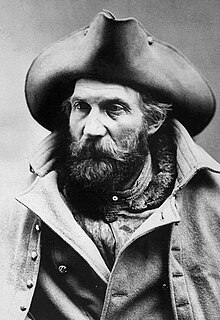
Henry S. Yount was an American Civil War soldier, mountain man, professional hunter and trapper, prospector, wilderness guide and packer, seasonal employee of the United States Department of the Interior, and the first game warden in Yellowstone National Park. He was nicknamed "Rocky Mountain Harry Yount".

The Yellowstone Caldera is a volcanic caldera and supervolcano in Yellowstone National Park in the Western United States, sometimes referred to as the Yellowstone Supervolcano. The caldera and most of the park are located in the northwest corner of Wyoming. The major features of the caldera measure about 34 by 45 miles.
The Yellowstone River is a tributary of the Missouri River, approximately 692 miles (1,114 km) long, in the Western United States. Considered the principal tributary of upper Missouri, this river, via its tributaries, drains a wide area, stretching from the Rocky Mountains in the vicinity of Yellowstone National Park, across the mountains and high plains of southern Montana and northern Wyoming.

Grand Teton is the highest mountain in Grand Teton National Park, in Northwest Wyoming, and a classic destination in American mountaineering.

Teton Wilderness is located in Wyoming, United States. Created in 1964, the Teton Wilderness is located within Bridger-Teton National Forest and consists of 585,238 acres (2,370 km2). The wilderness is bordered on the north by Yellowstone National Park and to the west by Grand Teton National Park and the John D. Rockefeller, Jr. Memorial Parkway. The Washakie Wilderness is to the east and the remainder of Bridger-Teton National Forest is to the south. The Teton Wilderness is a part of the 20 million acre (81,000 km2) Greater Yellowstone Ecosystem. Among many other features, Teton Wilderness is notable for having the most remote location of any place in the contiguous 48 states of the US. This location occurs very close to Bridger Lake, near the confluence of the Thorofare and Yellowstone Rivers, not far from the USFS Hawk's Rest Ranger Station.

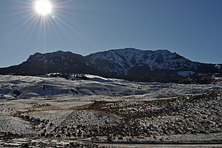
The Gallatin Range is a mountain range of the Rocky Mountains, located in the U.S. states of Montana and Wyoming. It includes more than 10 mountains over 10,000 feet (3,000 m). The highest peak in the range is Electric Peak at 10,969 feet (3,343 m).

Eagle Peak is a mountain in the Absaroka Range in the U.S. state of Wyoming and at 11,372 feet (3,466 m) is the highest point in Yellowstone National Park. It is located about 6 miles (9.7 km) east of the southeast arm of Yellowstone Lake.
Yount is an English surname. Notable people with the surname include:

The following articles relate to the history, geography, geology, flora, fauna, structures and recreation in Yellowstone National Park.
Mount Everts el. 7,846 feet (2,391 m) is a prominent mountain peak in Yellowstone National Park, Wyoming near Mammoth Hot Springs. The peak was named for Truman C. Everts, a member of the Washburn–Langford–Doane Expedition of 1870. Mount Everts is located immediately due south of Gardiner, Montana and due east of Mammoth Hot Springs.
Sepulcher Mountain el. 9,642 feet (2,939 m) is a moderate mountain peak in northwest Yellowstone National Park halfway between the summit of Electric Peak and Mammoth Hot Springs. The peak was named Sepulcher by Captain John W. Barlow, U.S. Army in 1871 because of its resemblance to a crypt when viewed from Gardiner, Montana.

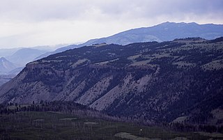
Specimen Ridge, el. 8,379 feet (2,554 m) is an approximately 8.5-mile (13.7 km) ridge along the south rim of the Lamar Valley in Yellowstone National Park. The ridge separates the Lamar Valley from Mirror Plateau. The ridge is oriented northwest to southeast from the Tower Junction area to Amethyst Mountain. The ridge is known for its abundance of amethyst, opal and petrified wood. It was referred to as Specimen Mountain by local miners and was probably named by prospectors well before 1870. The south side of the ridge is traversed by the 18.8-mile (30.3 km) Specimen Ridge Trail between Tower Junction and Soda Butte Creek. The trail passes through the Petrified Forest and over the summit of Amethyst Mountain el. 9,614 feet (2,930 m).

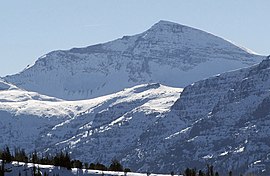
Mount Langford el. 10,623 feet (3,238 m) is a mountain peak in the Absaroka Range in Yellowstone National Park. The peak is named for Nathaniel P. Langford, the first superintendent of Yellowstone and a leader of the Washburn–Langford–Doane Expedition to Yellowstone in 1870. The expedition and Langford's subsequent promotion in Scribner's helped in the creation of the park in 1872.

Barlow Peak el. 9,609 feet (2,929 m) is an isolated mountain peak in the Big Game Ridge section of southwest Yellowstone National Park south of the Continental Divide. Barlow peak was named by geologist Arnold Hague in 1885 for Captain John W. Barlow an early topographical engineer mapping in the park.

The Thunderer el. 10,558 feet (3,218 m) is a mountain peak in the northeast section of Yellowstone National Park in the Absaroka Range. The Thunderer, named by members of the Arnold Hague Geological Survey of 1885 for it propensity to attract thunderstorms is a long high ridge just north of Mount Norris. Prior to 1885, the peak was considered just a high ridge extending north from Mount Norris. The Thunderer is easily visible from the northeast entrance road as it passes up the Soda Butte Creek canyon.

Mount Hancock el. 10,223 feet (3,116 m) is an isolated mountain peak on Big Game Ridge in Yellowstone National Park. Captain John W. Barlow named the peak in honor of General Winfield Scott Hancock during the Barlow-Heap Exploration of Yellowstone in 1871. General Hancock is noted for issuing the orders that established the military escort led by Lt. Gustavus Cheyney Doane for the Washburn–Langford–Doane Expedition of 1870.

Elk Mountain is in the northern Teton Range, Grand Teton National Park, Wyoming. The peak is part of a ridge immediately west of Owl Peak and the exact elevation is not known but is estimated to be between 10,720 and 10,800 feet. Elk Mountain is the northernmost peak in the Teton Range over 10,000 feet (3,000 m) in elevation. North of Elk Mountain, the Tetons blend into the Yellowstone Plateau.
Amethyst Mountain, el. 9,609 feet (2,929 m) is the highest peak and central part of a northwest – southeast trending ridge that lies between the Lamar River to the northeast and Deep Creek to the southwest within Park County, Wyoming. From northwest to southeast, this ridge consists of Specimen Ridge, Amethyst Mountain, and the Mirror Plateau in Yellowstone National Park. The nearest town is Silver Gate, Montana, which is 19.2 miles away.