Garretson, South Dakota | |
---|---|
Nickname: The City of Parks | |
Coordinates: 43°42′53″N96°30′10″W / 43.71472°N 96.50278°W | |
Country | United States |
State | South Dakota |
County | Minnehaha |
Incorporated | 1891 [1] |
Government | |
• Mayor | Greg Beaner [ citation needed ] |
• Deputy Mayor | Brayden Beaner [ citation needed ] |
Area | |
• Total | 1.50 sq mi (3.89 km2) |
• Land | 1.46 sq mi (3.77 km2) |
• Water | 0.04 sq mi (0.11 km2) |
Elevation | 1,486 ft (453 m) |
Population | |
• Total | 1,228 |
• Density | 843.41/sq mi (325.65/km2) |
Time zone | UTC−6 (Central (CST)) |
• Summer (DST) | UTC−5 (CDT) |
ZIP code | 57030 |
Area code | 605 |
FIPS code | 46-23820 |
GNIS feature ID | 1267400 [3] |
Website | cityofgarretson.com/ |
Garretson is a city in Minnehaha County, South Dakota, United States. The city had a population of 1,228 at the 2020 census. [5]
The city has the name of A. S. Garretson, a local banker. [6]
According to the United States Census Bureau, the city has a total area of 1.49 square miles (3.86 km2), of which 1.45 square miles (3.76 km2) is land and 0.04 square miles (0.10 km2) is water. [7]
Census | Pop. | Note | %± |
---|---|---|---|
1890 | 341 | — | |
1900 | 500 | 46.6% | |
1910 | 668 | 33.6% | |
1920 | 715 | 7.0% | |
1930 | 655 | −8.4% | |
1940 | 666 | 1.7% | |
1950 | 745 | 11.9% | |
1960 | 850 | 14.1% | |
1970 | 847 | −0.4% | |
1980 | 963 | 13.7% | |
1990 | 924 | −4.0% | |
2000 | 1,165 | 26.1% | |
2010 | 1,166 | 0.1% | |
2020 | 1,228 | 5.3% | |
U.S. Decennial Census [8] [4] |
As of the census [9] of 2010, there were 1,166 people, 449 households, and 308 families living in the city. The population density was 804.1 inhabitants per square mile (310.5/km2). There were 476 housing units at an average density of 328.3 per square mile (126.8/km2). The racial makeup of the city was 98.5% White, 0.3% African American, 0.3% Native American, and 0.6% from two or more races (Mulatto, Eurasian, mixed races) Hispanic or Latino of any race were 0.3% of the population.
There were 449 households, of which 38.5% had children under the age of 18 living with them, 53.9% were married couples living together, 10.7% had a female householder with no husband present, 4.0% had a male householder with no wife present, and 31.4% were non-families. 26.9% of all households were made up of individuals, and 12.9% had someone living alone who was 65 years of age or older. The average household size was 2.48 and the average family size was 3.03.
The median age in the city was 38.1 years. 28.6% of residents were under the age of 18; 5% were between the ages of 18 and 24; 26.4% were from 25 to 44; 24.8% were from 45 to 64; and 15.2% were 65 years of age or older. The gender makeup of the city was 47.0% male and 53.0% female.
As of the census of 2000, there were 1,165 people, 427 households, and 313 families living in the city. The population density was 786.9 inhabitants per square mile (303.8/km2). There were 458 housing units at an average density of 309.4 per square mile (119.5/km2). The racial makeup of the city was 97.60% White, 0.26% African American, 0.94% Native American, 0.09% Asian, 0.26% from other races, and 0.86% from two or more races. Hispanic or Latino of any race were 0.52% of the population.
There were 427 households, out of which 39.1% had children under the age of 18 living with them, 59.0% were married couples living together, 9.4% had a female householder with no husband present, and 26.5% were non-families. 24.4% of all households were made up of individuals, and 13.1% had someone living alone who was 65 years of age or older. The average household size was 2.59 and the average family size was 3.04.
In the city, the population was spread out, with 28.2% under the age of 18, 6.7% from 18 to 24, 29.3% from 25 to 44, 17.0% from 45 to 64, and 18.8% who were 65 years of age or older. The median age was 37 years. For every 100 females, there were 87.3 males. For every 100 females age 18 and over, there were 89.1 males.
As of 2000 the median income for a household in the city was $39,352, and the median income for a family was $46,389. Males had a median income of $32,212 versus $21,824 for females. The per capita income for the city was $16,981. About 3.1% of families and 4.6% of the population were below the poverty line, including 3.8% of those under age 18 and 10.7% of those age 65 or over.
Garretson is home to Devil's Gulch, the site where Jesse James allegedly escaped a posse after robbing the First National Bank in Northfield, Minnesota, and Split rock park, the site of the cities bathhouse from the founding.
Palisades State Park is also near Garretson.
Garretson Public Schools are part of the Garretson School District (South Dakota). The Garretson School District has one elementary school, one middle school, and one high school.
Students attend Garretson High School. [10]
Dakota City is a city in and the county seat of Humboldt County, Iowa, United States. The population was 759 at the time of the 2020 census. Dakota City shares its western border with the much larger city of Humboldt. It is the least populous county seat in Iowa.
Kindred is a city in Cass County, North Dakota, United States. The population was 889 at the time of the 2020 census. Kindred primarily serves as a bedroom community for Fargo, located about 25 miles to the southwest.
Page is a city in Cass County, North Dakota, United States. The population was 190 at the 2020 census. Page was founded in 1882.
Ellendale is a city in Dickey County, North Dakota, United States. It is the capital city of Dickey County. The population was 1,125 at the 2020 census. Ellendale was founded in 1882. Ellendale is the home of Trinity Bible College, located on the former campus of the North Dakota State Normal and Industrial School and the Ellendale Opera House currently under renovation.
McVille is a city in Nelson County, North Dakota, United States. The population was 392 at the 2020 census. McVille was founded in 1906.
Chamberlain is a city in Brule County, South Dakota, United States. It is located on the east bank of the Missouri River, at the dammed section of the Lake Francis Case, close to where it is crossed by Interstate 90.
Wagner is a city in Charles Mix County, South Dakota, United States. The population was 1,490 at the 2020 census. The city is served by Wagner Municipal Airport as well as YST Transit buses.
Clear Lake is a city in and the county seat of Deuel County, South Dakota, United States. The population was 1,218 at the 2020 census.
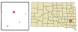
Burke is a city in and county seat of Gregory County, South Dakota, United States. The population was 575 at the 2020 census.
Freeman is a city in Hutchinson County, South Dakota, United States. The population was 1,329 at the 2020 census.
Parkston is a city in Hutchinson County, South Dakota, United States. The population was 1,567 at the 2020 census.
Lennox is a city in Lincoln County, South Dakota, United States, located 20 miles (32 km) southwest of Sioux Falls. The population was 2,423 at the 2020 census.
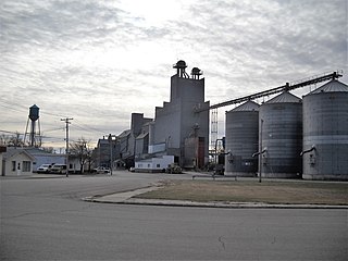
Salem is a city in and the county seat of McCook County, South Dakota, United States. The population was 1,325 at the 2020 census. The current mayor is Shawn English.
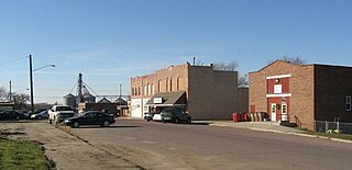
Leola is a small city in, and the county seat of, McPherson County, South Dakota, United States. It was founded on May 1, 1884, and named for Leola Haynes, daughter of one of the town's founders. The population was 434 as of the 2020 census.
Baltic is a city on the Big Sioux River in northern Minnehaha County, South Dakota, United States. The population was 1,246 at the 2020 census.
Crooks is a city in Minnehaha County, South Dakota, United States and is a suburb of Sioux Falls. The population was 1,362 at the 2020 census. Crooks was named New Hope until 1904. The town's present name honors W. A. Crooks, a local politician.
Sherman is a town in Minnehaha County, South Dakota, United States. The population was 81 at the 2020 census.
Elk Point is a city in and county seat of Union County, South Dakota, United States. The population was 2,149 as of the 2020 census.
Eagle Butte is a city in Dewey and Ziebach counties in South Dakota, United States. The population was 1,258 at the 2020 census.
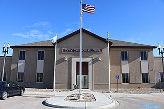
Box Elder is a city in Pennington and Meade counties in the State of South Dakota. The population was 11,746 according to the 2020 census, making it the 11th most populous city in South Dakota. Ellsworth Air Force Base lies on the northeast side of the city.