Gettysburg Battlefield Historic District

Last updated
Gettysburg Battlefield Historic District
Gettysburg mon 111th NY Inf.JPG
Memorial on the Gettysburg Battlefield to the 111th New York Infantry, February 2012
USA Pennsylvania location map.svg
Red pog.svg
Usa edcp location map.svg
Red pog.svg
Location Adams County, Pennsylvania
Coordinates 39°48′59″N77°13′49″W / 39.81639°N 77.23028°W / 39.81639; -77.23028
Area~11,000 acres (4,500 ha) [1]
Architectural style Colonial (1776 tavern),

Neoclassical (1797 hotel),
Vernacular (1815 academy) [2]
Federal (1815 house),
Greek Revival (1837 "edifice"),
Italianate (1855 gatehouse), [3]
Gothic Revival (1862 home),
Queen Anne (1883 house)
Romanesque (1889 hall),
Castellated tower (1889 monument)
Box truss (1895 observatory
Beaux-Arts (1906 bank) [2]
Parkitecture (1933 station), [4] [5] :'33
Art deco (1938 armory)

Contents

Modernist (1962 museum)
MPS Battle of Gettysburg MPS
NRHP reference No. 75000155 [6]
Added to NRHPMarch 19, 1975

The Gettysburg Battlefield Historic District is a district of contributing properties and over 1000 historic contributing structures and 315 historic buildings, located in Adams County, Pennsylvania. The district was added to the National Register of Historic Places on March 19, 1975. [7] Most of the contributing elements of the Gettysburg Battlefield are on the protected federal property within the smaller Gettysburg National Military Park.

Historic structures include the Battle of Gettysburg monuments and memorials. Historic buildings range from a 1776 Colonial tavern to a vacant 1962 Modernist museum (Demolished in 2013). Contributing structures include postbellum artifacts such as the 1895 Big Round Top Observation Tower Foundation Ruin, the 1893 Electric Trolley Bed, and the only remaining Tipton Boundary Marker. [8]

History

The Eternal Light Peace Memorial was unveiled at the 1938 Gettysburg reunion. Gettysburg ELPMemorial.jpg
The Eternal Light Peace Memorial was unveiled at the 1938 Gettysburg reunion.

Historical events regarding the district's registered/documented properties include the famous 1863 Battle of Gettysburg and Gettysburg Address, and the subsequent Gettysburg Battlefield memorial development, historic commemorations, and addition of visitor services during the subsequent administrative eras. Events preceding the battle include the prehistoric geomorphological events which formed the battlefield terrain that was an integral part of the battle, as well as the construction of structures subsequently associated with the battle. Notable antebellum structures that no longer exist include the 1761 [9] Samuel Gettys tavern, as well as the c.1790 McAllister Mill along Rock Creek used by the Underground Railroad. The 1776 Dobbin House Tavern was outside of the borough when it was surveyed in 1785, [10] and the 1786 Brafferton Inn (Hoke-Codori House) [10] is the "oldest deeded house in downtown Gettysburg". [11] The c.1795 pub (Quinn's 1859 "Railroad Store", [12] 1924 Mitchell's Restaurant) [11] on the northeast of the center square subsequently burned and has been restored. [13] By 1934, the first National Park Service Parkitecture of Gettysburg granite had been completed near The Pennsylvania State Memorial.

Official groupings of historical real estate tracts began with the 1864 Gettysburg Battlefield Memorial Association era, and continued with the initial United States Department of War acquisitions in 1893. The 1895 "Sickles Gettysburg Park Bill" (28 Stat. 651) designated the Gettysburg National Military Park (GNMP), [14] which included areas outside of the battlefield (e.g., structures used as field hospitals) and which was transferred in 1933 to the 1916 National Park Service. The GNMP was added to the national register in 1966, and the Gettysburg Borough Council adopted a Historic District ordinance in 1972. [15]

The historic district, which covers a larger area than either the national park or the battlefield, was designated via 2 multiple property submissions of contributing structures and properties, the first being the Battle of Gettysburg MPS on March 19, 1975. The list of classified structures was expanded from 618 to 1200 entries c.1993, [16] and the second MPS was dated January 23, 2004. [8]

The Civil War Trust (a division of the American Battlefield Trust) and its partners have acquired and preserved 1,022 acres (4.14 km2) within the battlefield historic district in more than 30 separate acquisitions since 1997. Some of these acres are now part of the Gettysburg National Military Park, but many continue to be owned by the Trust. [17]

See also

Related Research Articles

<span class="mw-page-title-main">Gettysburg, Pennsylvania</span> Borough in Pennsylvania, USA

Gettysburg is a borough in and the county seat of Adams County, Pennsylvania, United States. As of the 2020 census, the borough had a population of 7,106 people.

<span class="mw-page-title-main">Gettysburg National Cemetery</span> Battlefield cemetery created following the Battle of Gettysburg

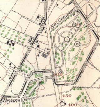
Gettysburg National Cemetery is a United States national cemetery in Gettysburg, Pennsylvania created for Union casualties from the Battle of Gettysburg in the American Civil War. The Battle of Gettysburg, which was fought between July 1 to 3, 1863, resulted in the largest number of casualties of any Civil War battle but also was considered the war's turning point, leading ultimately to the Union victory.

<span class="mw-page-title-main">Gettysburg Battlefield</span> American Civil War battle-site

The Gettysburg Battlefield is the area of the July 1–3, 1863, military engagements of the Battle of Gettysburg within and around the borough of Gettysburg, Pennsylvania. Locations of military engagements extend from the 4-acre (1.6 ha) site of the first shot at Knoxlyn Ridge on the west of the borough, to East Cavalry Field on the east. A military engagement prior to the battle was conducted at the Gettysburg Railroad trestle over Rock Creek, which was burned on June 27.

<span class="mw-page-title-main">Gettysburg National Military Park</span> Larger area encompassing the National Cemetery and Battlefield

The Gettysburg National Military Park protects and interprets the landscape of the Battle of Gettysburg, fought over three days between July 1 and July 3, 1863, during the American Civil War. Located in Gettysburg, Pennsylvania, the park is managed by the National Park Service.

<span class="mw-page-title-main">Devil's Den</span> Section of combat during the Second day of the Battle of Gettysburg

Devil's Den is a boulder-strewn hill on the south end of Houck's Ridge at Gettysburg Battlefield, used by artillery and sharpshooters on the second day of the 1863 Battle of Gettysburg during the American Civil War. A tourist attraction since the memorial association era, several boulders are worn from foot traffic and the site includes numerous cannons, memorials, and walkways, including a bridge spanning two boulders.

<span class="mw-page-title-main">Evergreen Cemetery (Adams County, Pennsylvania)</span> Historic cemetery in Adams County, Pennsylvania

Evergreen Cemetery – formerly called Citizen's Cemetery and Ever Green Cemetery – is a historic 29.12 acre rural cemetery located just outside Gettysburg Borough, in Cumberland Township, Adams County, Pennsylvania, United States. It is part of Gettysburg Battlefield Historic District, and is surrounded by Gettysburg National Military Park and Soldiers' National Cemetery.

<span class="mw-page-title-main">Brian Farm</span> American Civil War site in Gettysburg National Military Park, Pennsylvania

The Brian Farm is an American Civil War area of the Gettysburg Battlefield used during the Pickett's Charge. On January 23, 2004, the farm's buildings, Boundary Stone Wall, and ID tablet were designated historic district contributing structures after the tract was used for the 1918 Camp Colt and other postwar camps.

Gettysburg may refer to:

<span class="mw-page-title-main">Round Top, Pennsylvania</span> Unincorporated community in Pennsylvania, United States

Round Top is a populated place in Adams County in the U.S. state of Pennsylvania, near Little Round Top. It is notable for two Battle of Gettysburg hospitals, the 1884 Round Top Station, and several battlefield commemorative era attractions such as Round Top Park and the Round Top Museum. The unincorporated community lies on an elevated area of the north-south Taneytown Road with three intersections: at Blacksmith Shop Road to the northeast, Wheatfield Road, and Sachs Road.

Plum Run is a Pennsylvania stream flowing southward from the Gettysburg Battlefield between the Gettys-Black Divide on the east and on the west, the drainage divide for Pitzer Run, Biesecker Run, Willoughby Run, and Marsh Creek.

<span class="mw-page-title-main">Gettysburg Electric Railway</span> Borough trolley serving Gettysburg Battlefield attractions

The Gettysburg Electric Railway was a borough trolley that provided summer access to Gettysburg Battlefield visitor attractions such as military engagement areas, monuments, postbellum camps, and recreation areas. Despite the 1896 Supreme Court ruling under the Takings Clause against the railway, battlefield operations continued until 1916. The trolley generating plant was leased by the Electric Light, Heat, and Power Company of Gettysburg to supply streetlights and homes until electricity was imported from Hanover.

United States v. Gettysburg Electric Ry. Co., 160 U.S. 668 (1896), was a case to prevent trolley operations on the Gettysburg Battlefield. The dispute began in August 1891 when the Gettysburg Battlefield Memorial Association's board approved attorney Samuel Swope's motion to deny trolley right-of-way along GBMA roads. Despite the 1896 US Supreme Court ruling that the railway could be seized for historic preservation, as well as earlier legislative efforts to appropriate federal acquisition funds, create a War Department commission, and form the Gettysburg National Military Park; the trolley continued operations until obsolete in 1916.

<span class="mw-page-title-main">72nd Pennsylvania Infantry Monument</span>

The 72nd Pennsylvania Infantry Monument is an 1891 statuary memorial on the Gettysburg Battlefield. It is located on Cemetery Ridge, by The Angle and the copse of trees, where Union forces – including the 72nd Pennsylvania Infantry – beat back Confederate forces engaged in Pickett's Charge.

Emmor Cope (1834-1927) was an American Civil War officer of the Union Army noted for the "Map of the Battlefield of Gettysburg from the original survey made August to October, 1863", which he researched by horseback as a sergeant after being ordered back to Gettysburg by Maj. Gen. George G. Meade. Cope is also noted for commemorative era battlefield administration and designs, including the layout of the 1913 Gettysburg reunion. Cope had enlisted as a Private of Company A,, temporarily detached to Battery C, 5th U.S. Artillery, and mustered out as a V Corps aide-de-camp of Maj Gen Gouverneur K. Warren.

<span class="mw-page-title-main">Tipton Station</span> Historic trolley stop in Pennsylvania

Tipton Station was a Gettysburg Battlefield trolley stop of the Gettysburg Electric Railway for passenger access to Crawford's Glen to the north, Devil's Den (west), and Tipton Park (east). The station was established during the 1894 construction of the end of the trolley line and was near the Devil's Den trolley siding, south of the trolley's Warren Avenue crossing, and northeast of the Plum Run trolley bridge. An uphill trail led southwest to Big Round Top with its 1895 Observation Tower, and the "Slaughter Pen Path and Steps" were built to Devil's Den.

<span class="mw-page-title-main">Gettysburg Battlefield Memorial Association</span>

The Gettysburg Battlefield Memorial Association (GBMA) was an historic preservation membership organization and is the eponym for the battlefield's memorial association era. The association was chartered by the Commonwealth of Pennsylvania on April 13, 1864, after attorney David McConaughy recommended on August 14, 1863, a preservation association to sell membership stock for battlefield fundraising. McConaughy transferred his land acquired in 1863 to the GBMA, and the association's boardmembers were initially local officials. The GBMA sold stock to raise money, hired a superintendent at $1000/yr, added to McConaughy's land holdings, and operated a wooden observation tower on East Cemetery Hill from 1878–95.

<span class="mw-page-title-main">Evergreen Cemetery gatehouse</span> Historic structure in Adams County, Pennsylvania

Evergreen Cemetery gatehouse (1855) is a historic building located at 799 Baltimore Pike in Adams County, Pennsylvania. During the American Civil War, the gatehouse played an important role in the July 1 to 3, 1863 Battle of Gettysburg. It is a contributing structure in Gettysburg Battlefield Historic District.

<span class="mw-page-title-main">McPherson Ridge</span> Landform in Adams County, Pennsylvania, U.S.

McPherson Ridge is a landform used for military engagements during the 1863 Battle of Gettysburg, when the I Corps of the Union Army had a headquarters on the ridge and was defeated by the Confederate division of Major General Henry Heth. The ridge has terrain above ~530 ft (160 m) and is almost entirely a federally protected area except for township portions at the southern end and along Pennsylvania Route 116, including a PennDOT facility. The northern end is a slight topographic saddle point on the west edge of Oak Ridge, and summit areas above 560 ft (170 m) include 4 on/near the Lincoln Highway, a broader summit south of the Fairfield Road, and the larger plateau at the northern saddle.

<span class="mw-page-title-main">Rose Woods</span>

Rose Woods is a Gettysburg Battlefield forested area that is an American Civil War site of the battle's Hood's Assault, McLaws' Assault, and McCandless' Advance. "Scene of the first line of Union defenses" on the Battle of Gettysburg, Second Day; the 1st Texas Infantry and 3rd Arkansas Infantry Regiments attacked Ward's 2nd Brigade line in the woods. The last combat on the Battle of Gettysburg, Third Day, was "in the early evening. Colonel William McCandless's brigade of Pennsylvania Reserves advanced across the Wheatfield into Rose's Woods where they managed to inflict heavy losses on the 15th Georgia" which had failed to retreat to Warfield Ridge after Longstreet's Assault. Two days later Timothy H. O'Sullivan photographed corpses moved for burial to the edge of Rose Woods and which were subsequently reinterred in cemeteries.

References

  1. Cultural Landscapes Inventory: Professional Procedures Guide (PDF) (Report). NPS.gov. January 2009. Retrieved 2011-02-22. The approximately 11,000-acre Gettysburg Battlefield Historic District embraces the land area associated with the battle of Gettysburg. … In a more complex park, such as Gettysburg National Military Park, the CLI could identify the 3,965 acre park as the landscape
  2. 1 2 "Gettysburg Borough". LivingPlaces.com. Retrieved 2011-05-08. the Reuning House built as the Academy Building at 66 West High Street. It was built in 1813-15 for the Gettysburg Academy, but its architecture displays characteristics of the vernacular residential style … Adams County National Bank which was constructed in 1906. The structure is an excellent example of Beaux Arts Classicism
  3. "Collector Items". EvergreenCemetery.org. Archived from the original on 2011-07-20. Retrieved 2011-04-11.
  4. "New Comfort Station to be Built on Field" (Google News Archive). Gettysburg Times . May 5, 1933. Retrieved 2011-04-11.
  5. Gettysburg National Military Park Commission. "An Introduction to the Annual Reports of the Gettysburg National Military Park Commission to the Secretary of War". The Gettysburg Commission Reports. Gettysburg, PA: War Department.
  6. "National Register Information System". National Register of Historic Places . National Park Service. November 2, 2013.
  7. Harrison, Thomas J. (February 1974). "NRHP Registration Form: Gettysburg Battlefield Historic District" (PDF). National Park Service. CRGIS: Cultural Resources Geographic Information System for Pennsylvania.
  8. 1 2 "List of Classified Structures". NPS.gov. by "structure number":
    RR02: "Electric Trolley Bed". Archived from the original on 2011-07-21. Retrieved 2011-03-02. [rail] trail along Plum Run at Devils Den, runs N through Rose Farm & stops near The Loop.
    MN807: "Tipton Boundary Marker". Archived from the original on 2011-07-21. Retrieved 2011-03-02. approximately, 7"x7"x1'. Inscribed "T" on top of marker. … rough granite with a "T" inscribed on the top. … at a corner of Tipton land purchased in March 1892 as part of the Tipton Park and photographic studio.NPS02: "Old Slaughter Pen Path and Steps". Archived from the original on 2011-07-21. Retrieved 2011-03-04. used by trolley passengers … Path and steps are now used as a Park trail. … Path runs N/S from Plum Run to Sickles Avenue.
  9. "Historical Gettysburg, PA". GettysburgWebInfo.com. Retrieved 2011-04-20. In 1761, A Scots-Irish settler, Samuel Gettys, established a tavern in the area.
  10. 1 2 "The_Colonial_Period". Kevintrostle.com. Retrieved 2013-11-16.
  11. 1 2 "Gettysburg Times - Google News Archive Search". news.google.com. Retrieved 14 March 2019.
  12. "The Compiler - Google News Archive Search". news.google.com. Retrieved 14 March 2019.
  13. Butko, Brian (2002). Lincoln Highway - Brian Butko - Google Boeken. ISBN   9780811724975 . Retrieved 2013-11-16.
  14. "Gettysburg National Military Park Established By Sickles, Bill Passed In February 1895" (Google News Archive). Gettysburg Times. February 10, 1970. Retrieved 2011-01-26.
  15. "Borough of Gettysburg …historic crossroads". Borough Office. Archived from the original on 2011-06-12. Retrieved 2011-04-11.
  16. "Gettysburg Times - Google News Archive Search". news.google.com. Retrieved 14 March 2019.
  17. American Battlefield Trust "Saved Land" webpage. Accessed May 24, 2018.