
Bayside is an unincorporated community 2.25 miles (3.6 km) south-southeast of Arcata, at an elevation of 33 feet in Humboldt County, California. The ZIP Code is 95524, the area code is 707. The relatively large area was originally covered by large, ancient Coast Redwood trees down to what was the edge of a significantly larger Humboldt Bay at high tide. Later, the mammoth redwoods made it the natural placement of some of the area's earliest redwood lumber operations. A rock quarry was located in the area's hills, which form the beginning of the Coast Ranges, the source of water for an early public water system for the City of Arcata. Today, Bayside provides Arcata a buffer from Eureka's northward expansion along US Route 101 and the area, with the exception of some business and public buildings, is largely rural, with homes and small ranches dotting the landscape. Second growth forests exist mostly apart from cleared lands, which show some evidence of the extensive redwood forest that once existed in the form of large stumps. Some of the area's older Victorian era houses, are still present on the Old Arcata Road, the original main road connecting Arcata to Eureka. Jacoby Creek runs alongside a road of the same name from the hills in the direction of the Bay.
Table Bluff is a semi-flat terrace in Humboldt County, California, that terminates above the ocean in a dramatic, 165-foot (50 m) high cliff with views of the Eel River delta, the South Spit of Humboldt Bay, and the Pacific Ocean. It separates Humboldt Bay to the north from the Eel River to the south. It overlooks approximately 9,000 acres (36 km²) of wildlands administered by various federal and county agencies. It is 12 miles (19 km) south of Eureka and 5.5 miles (8.9 km) west of US Highway 101. Table Bluff County Park provides access to the South Spit. The park is also used as a hang-gliding staging area. The federally endangered western lily, Lilium occidentale, is found growing on Table Bluff at Table Bluff Ecological Reserve.
The Blue Lake Rancheria of the Wiyot, Yurok, and Hupa Indians is located northwest of the city of Blue Lake in Humboldt County, California on approximately 76 acres (0.31 km2). As of 2007, there were 53 enrolled members. As of the 2010 Census the population of Blue Lake Rancheria was 58.

Rosewood is an unincorporated community in Humboldt County, California. It is located 1 mi (1.6 km) south of Eureka, at an elevation of 131 feet.

The Bear River Band of the Rohnerville Rancheria is a federally recognized tribe of Mattole, Bear River and Wiyot people in Humboldt County, California.

Waukell Flat is a former settlement in Del Norte County, California. It was located on the south bank of the Klamath River 4.25 miles (6.8 km) from its mouth, at an elevation of 23 feet. It still appeared on maps as of 1952.

Brainard is an unincorporated community in Humboldt County, California. It is located on the Northwestern Pacific Railroad 4 miles (6.4 km) south-southwest of Arcata, at an elevation of 7 feet.
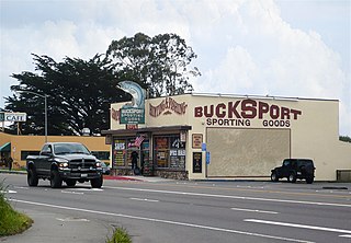
Bucksport was a town in Humboldt County, California. The original location was 2.5 miles (4 km) southwest of downtown Eureka, on Humboldt Bay about 5 miles (8 km) northeast of entrance. at an elevation of 16 feet (4.9 m). Prior to American settlement a Wiyot village named Kucuwalik stood here.
Calville was a community in Humboldt County, California, located 4.5 miles (7.2 km) north of Arcata, at an elevation of 154 feet. It is centered on Sutter Road and Central Avenue, and became part of the large unincorporated community of McKinleyville.
Elk Grove is a former settlement in Humboldt County, California. It was located 6 miles (9.7 km) north-northeast of Orick, at an elevation of 151 feet. It still appeared on maps as of 1947.
Elk River is an unincorporated community in Humboldt County, California. It is located 2.25 miles (3.6 km) east-northeast of Fields Landing, at an elevation of 69 feet. All the residents of this neighborhood have Eureka, California addresses.
Essex is a locality in Humboldt County, California. It is located on the Mad River 3.5 miles (5.6 km) northeast of Arcata, at an elevation of 75 feet (23 m).
Fairhaven is an unincorporated community and census-designated place (CDP) adjacent to Humboldt Bay in Humboldt County, California, United States. It is located 2.25 miles (3.6 km) west-southwest of downtown Eureka, at an elevation of 10 feet (3.0 m) above sea level.
Freshwater Corners is an unincorporated community in Humboldt County, California. It is located 6 miles (9.7 km) south of Arcata and 2 miles (3.2 km) northwest of Freshwater, at an elevation of 13 feet. All residents of this area have Eureka, California addresses.
Ridgewood Heights, is an unincorporated community in Humboldt County, California. It is located 3.5 miles (5.6 km) east-northeast of Fields Landing, at an elevation of 417 feet. This neighborhood is part of unincorporated Eureka, California, located entirely within the 95503 zip code.

Rohnerville is an unincorporated community in Humboldt County, California. It is located 2.25 miles (3.6 km) southeast of Fortuna, at an elevation of 197 feet.
Stafford is an unincorporated community in Humboldt County, California. It is located on the south bank of the Eel River 3 miles (4.8 km) southeast of Scotia, at an elevation of 138 feet.
Table Bluff is a locality in Humboldt County, California. It is located adjacent to the Pacific Ocean 4.5 miles (7.2 km) south of Fields Landing, at an elevation of 318 feet (97 m).
Humboldt City is a former settlement in Humboldt County, California. It was located on Humboldt Bay just south of the later site of Bucksport. The townsite was laid out in 1850 but was nearly deserted by 1851.
The Wiyot Tribe is a federally recognized tribe of Wiyot people. They are the aboriginal people of Humboldt Bay, Mad River, and lower Eel River.


