Goldthwaite, Texas

Last updated

Goldthwaite, Texas
City
Another look at downtown Goldthwaite IMG 0782.JPG
Downtown Goldthwaite
Nickname: 
Windmill City
TXMap-doton-Goldthwaite.PNG
Location of Goldthwaite, Texas
Mills County Goldthwaite.svg
Coordinates: 31°27′2″N98°34′16″W / 31.45056°N 98.57111°W / 31.45056; -98.57111
CountryUnited States
State Texas
County Mills
Area
[1]
  Total2.07 sq mi (5.35 km2)
  Land2.02 sq mi (5.23 km2)
  Water0.05 sq mi (0.12 km2)
Elevation
1,572 ft (479 m)
Population
 (2010)
  Total1,878
  Estimate 
(2019) [2]
1,833
  Density907.88/sq mi (350.51/km2)
Time zone UTC-6 (Central (CST))
  Summer (DST) UTC-5 (CDT)
ZIP code
76844
Area code 325
FIPS code 48-30056 [3]
GNIS feature ID1358127 [4]
Website Official website

Goldthwaite is a town and the county seat of Mills County, Texas, United States. [5] The population was 1,738 at the 2020 census [6] and 1,878 at the 2010 census.

Contents

History

Goldthwaite existed as a small village prior to the arrival of the Gulf, Colorado and Santa Fe Railway in 1885. The population increased after the railway began selling lots. [7] The town is named after George (Joe) Goldthwaite (1836–1892), an employee at the railway. [7] Goldthwaite was once known as "The City of Windmills" because of the large number of wells in the city. [7]

Geography

According to the United States Census Bureau, the city has a total area of 1.7 square miles (4.4 km2), all land.

Climate

The climate in this area is characterized by hot, humid summers and generally mild to cool winters. According to the Köppen climate classification system, Goldthwaite has a humid subtropical climate, Cfa on climate maps. [8]

Climate data for Goldthwaite, Texas, 1991–2020 normals, extremes 1960–present
MonthJanFebMarAprMayJunJulAugSepOctNovDecYear
Record high °F (°C)88
(31)
98
(37)
98
(37)
99
(37)
104
(40)
108
(42)
109
(43)
110
(43)
108
(42)
99
(37)
91
(33)
86
(30)
110
(43)
Mean maximum °F (°C)77.5
(25.3)
80.3
(26.8)
85.4
(29.7)
90.3
(32.4)
94.3
(34.6)
96.5
(35.8)
99.8
(37.7)
99.9
(37.7)
96.2
(35.7)
90.7
(32.6)
82.8
(28.2)
77.0
(25.0)
101.7
(38.7)
Mean daily maximum °F (°C)58.0
(14.4)
61.7
(16.5)
68.9
(20.5)
76.2
(24.6)
82.5
(28.1)
89.1
(31.7)
92.9
(33.8)
93.3
(34.1)
87.4
(30.8)
78.0
(25.6)
67.1
(19.5)
59.3
(15.2)
76.2
(24.6)
Daily mean °F (°C)45.5
(7.5)
49.5
(9.7)
56.7
(13.7)
64.4
(18.0)
71.9
(22.2)
78.7
(25.9)
81.8
(27.7)
82.1
(27.8)
76.3
(24.6)
66.3
(19.1)
55.4
(13.0)
47.4
(8.6)
64.7
(18.2)
Mean daily minimum °F (°C)33.0
(0.6)
37.4
(3.0)
44.5
(6.9)
52.6
(11.4)
61.3
(16.3)
68.3
(20.2)
70.7
(21.5)
70.9
(21.6)
65.1
(18.4)
54.7
(12.6)
43.8
(6.6)
35.4
(1.9)
53.1
(11.8)
Mean minimum °F (°C)19.1
(−7.2)
22.1
(−5.5)
27.4
(−2.6)
35.7
(2.1)
46.7
(8.2)
60.3
(15.7)
66.2
(19.0)
65.0
(18.3)
52.0
(11.1)
37.1
(2.8)
26.5
(−3.1)
20.9
(−6.2)
15.8
(−9.0)
Record low °F (°C)4
(−16)
0
(−18)
8
(−13)
28
(−2)
32
(0)
50
(10)
57
(14)
53
(12)
40
(4)
24
(−4)
12
(−11)
−7
(−22)
−7
(−22)
Average precipitation inches (mm)1.70
(43)
2.23
(57)
2.42
(61)
2.23
(57)
4.21
(107)
4.16
(106)
1.82
(46)
2.01
(51)
2.51
(64)
3.49
(89)
2.06
(52)
1.60
(41)
30.44
(774)
Average precipitation days (≥ 0.01 in)5.96.07.05.57.56.24.25.15.05.95.55.769.5
Source 1: NOAA [9]
Source 2: National Weather Service [10]

Demographics

Historical population
CensusPop.Note
1900 1,282
1910 1,129−11.9%
1920 1,2147.5%
1930 1,3249.1%
1940 1,4146.8%
1950 1,56610.7%
1960 1,383−11.7%
1970 1,69322.4%
1980 1,7835.3%
1990 1,658−7.0%
2000 1,8028.7%
2010 1,8784.2%
2019 (est.)1,833 [2] −2.4%
U.S. Decennial Census [11]

2020 census

Goldthwaite racial composition [12]
(NH = Non-Hispanic) [lower-alpha 1]
RaceNumberPercentage
White (NH)1,21569.91%
Black or African American (NH)40.23%
Native American or Alaska Native (NH)70.4%
Asian (NH)20.12%
Some Other Race (NH)10.06%
Mixed/Multi-Racial (NH)573.28%
Hispanic or Latino 45226.01%
Total1,738

As of the 2020 United States census, there were 1,738 people, 742 households, and 463 families residing in the city.

2000 census

At the 2000 census, [3] there were 1,802 people, 740 households and 466 families residing in the city. The population density was 1,047.4 inhabitants per square mile (404.4/km2). There were 883 housing units at an average density of 513.2 per square mile (198.1/km2). The racial makeup of the city was 87.01% White, 0.39% African American, 0.06% Native American, 0.17% Asian, 0.11% Pacific Islander, 10.82% from other races, and 1.44% from two or more races. Hispanic or Latino of any race were 18.42% of the population.

There were 740 households, of which 29.1% had children under the age of 18 living with them, 48.8% were married couples living together, 11.6% had a female householder with no husband present, and 37.0% were non-families. 35.3% of all households were made up of individuals, and 23.4% had someone living alone who was 65 years of age or older. The average household size was 2.23 and the average family size was 2.87.

Age distribution was 24.6% under the age of 18, 4.9% from 18 to 24, 21.4% from 25 to 44, 20.5% from 45 to 64, and 28.5% who were 65 years of age or older. The median age was 44 years. For every 100 females, there were 81.5 males. For every 100 females age 18 and over, there were 76.1 males.

The median household income was $26,731, and the median family income was $34,940. Males had a median income of $25,577 versus $19,602 for females. The per capita income for the city was $14,591. About 12.5% of families and 18.7% of the population were below the poverty line, including 21.8% of those under age 18 and 22.2% of those age 65 or over.

Education

Goldthwaite, ca. 1907 View of Goldthwaite, Texas, ca. 1907.jpg
Goldthwaite, ca. 1907

Goldthwaite is served by the Goldthwaite Independent School District. Schools located in Goldthwaite included Goldthwaite Elementary School, Goldthwaite Middle School, and Goldthwaite High School. New Horizons Ranch School is located off Farm-to-Market Road 574. [15]

Infrastructure

The City of Goldthwaite owns and operates the Goldthwaite Municipal Airport, a general aviation airport with a 3,200 ft × 60 ft (975 m × 18 m) asphalt runway. [16] The airport originally opened in 2011. In 2015, 10 T-hangars, a hangar apron, an access road, and a garage storage area for a courtesy car were constructed, and a fly-in golf program was offered in partnership with the adjacent golf course. [17]

Notable people

Related Research Articles

<span class="mw-page-title-main">Point Comfort, Texas</span> City in Texas, United States

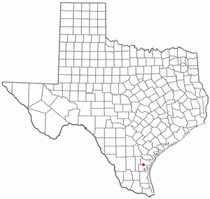
Point Comfort is a city in Calhoun County, Texas, United States. It is a part of the Victoria, Texas Metropolitan Statistical Area. The population was 737 at the 2010 census.

<span class="mw-page-title-main">Coleman, Texas</span> City in Texas, United States

Coleman is a town in and the county seat of Coleman County, Texas, United States. As of the 2010 census, its population was 4,709.

<span class="mw-page-title-main">Comanche, Texas</span> Community in Texas, United States

Comanche is a city located in Comanche County in the U.S. state of Texas. The population was 4,335 at the 2010 census. It is the county seat of Comanche County.

<span class="mw-page-title-main">Paducah, Texas</span> Town in Cottle County, Texas, United States

Paducah is a town in Cottle County, Texas, United States. The population was 1,186 at the 2010 census, down from 1,498 in 2000. It is the county seat of Cottle County. It is just south of the Texas Panhandle and east of the Llano Estacado.

<span class="mw-page-title-main">Itasca, Texas</span> City in Texas, United States

Itascaeye-TAS-kə is a city in Hill County in Northern Central Texas, United States. As of the 2010 census, the city population was 1,644.

<span class="mw-page-title-main">Stinnett, Texas</span> City in Texas, United States

Stinnett is a city in and the county seat of Hutchinson County, Texas, United States. The population was 1,881 at the 2010 census, a decrease from 1,936 at the 2000 census.

<span class="mw-page-title-main">Jayton, Texas</span> City in Texas, United States

Jayton is a city in and the county seat of Kent County, Texas, United States. It is located in the northeastern portion of the county, and the population was 511 as of the 2020 census.

<span class="mw-page-title-main">Lipscomb, Texas</span> Census-designated place in Texas, United States

Lipscomb is an unincorporated community and census-designated place (CDP) in Lipscomb County, Texas, United States. It is the Lipscomb county seat. The population was 37 at the 2010 census.

<span class="mw-page-title-main">Tahoka, Texas</span> City in Texas, United States

Tahoka is a city in and the county seat of Lynn County, Texas, United States. The population was 2,673 at the 2010 census.

<span class="mw-page-title-main">Madisonville, Texas</span> City in Texas, United States

Madisonville is a city in Madison County, Texas, United States. The population was 4,420 at the 2020 census. It is the county seat of Madison County. Both the City of Madisonville and the County of Madison were named for U.S. President James Madison, the fourth chief executive.

<span class="mw-page-title-main">Hondo, Texas</span> City in Texas, United States

Hondo is a city in and the county seat of Medina County, Texas, United States. According to the 2010 Census, the population was 8,803. It is part of the San Antonio Metropolitan Statistical Area.

<span class="mw-page-title-main">Bishop, Texas</span> City in Texas, United States

Bishop is a city in Nueces County, Texas, United States. The population was 3,174 as of the 2020 census, up from 3,134 in the 2010 census.

<span class="mw-page-title-main">Emory, Texas</span> City in Texas, United States

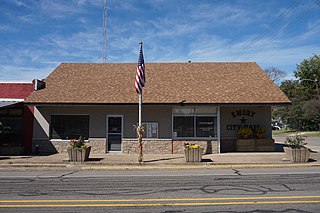
Emory is a city in Rains County, Texas, United States. The population was 1,239 at the 2010 census. It is the county seat of Rains County. Previously known as Springville, the city and county are named after Emory Rains, who was a legislator from the area. Rains was the author of the Homestead Law of Texas, which was later used as a model for the protection of homesteads throughout the United States. Special legislation passed to create Rains County called for the citizens to vote on the location of the county seat and for that selected town to be named Emory.

<span class="mw-page-title-main">Stratford, Texas</span> Town in Texas, United States

Stratford is a town and county seat of Sherman County, Texas, United States. The population was 2,017 at the 2010 census, up from 1,991 in 2000.

<span class="mw-page-title-main">Aspermont, Texas</span> Town in Texas, United States

Aspermont is a town and the county seat of Stonewall County, Texas. The population was 789 at the 2020 census.

<span class="mw-page-title-main">Mount Pleasant, Texas</span> City in Texas, United States

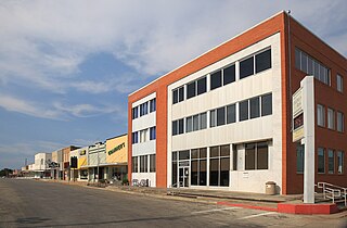
Mount Pleasant is the county seat of and largest city in Titus County, in the U.S. state of Texas. As of the 2020 census, Mount Pleasant's population was 16,047; it is situated in Northeast Texas.

<span class="mw-page-title-main">Wheeler, Texas</span> City in Texas, United States

Wheeler is a city, and the county seat of Wheeler County, Texas, United States, located on the eastern border of the Texas Panhandle. The population was last reported at 1,592 in the 2010 census.

<span class="mw-page-title-main">Liberty Hill, Texas</span> City in Williamson County, Texas, United States

Liberty Hill is a city in Williamson County, Texas, United States. The population was 3,646 at the 2020 census. Liberty Hill is part of the Greater Austin metropolitan area.

<span class="mw-page-title-main">Stockdale, Texas</span> City in Texas, United States

Stockdale is a city in Wilson County, Texas, United States. The population was 1,413 at the 2020 census. It is part of the San Antonio Metropolitan Statistical Area.

<span class="mw-page-title-main">Aransas Pass, Texas</span> City in Texas, United States

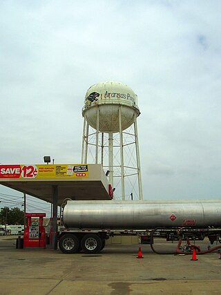
Aransas Pass is a city in Aransas, Nueces, and San Patricio Counties in the U.S. state of Texas. The population was 8,011 at the 2021 Census.

References

  1. "2019 U.S. Gazetteer Files". United States Census Bureau. Retrieved August 7, 2020.
  2. 1 2 "Population and Housing Unit Estimates". United States Census Bureau. May 24, 2020. Retrieved May 27, 2020.
  3. 1 2 "U.S. Census website". United States Census Bureau . Retrieved January 31, 2008.
  4. "US Board on Geographic Names". United States Geological Survey. October 25, 2007. Retrieved January 31, 2008.
  5. "Find a County". National Association of Counties. Archived from the original on May 31, 2011. Retrieved June 7, 2011.
  6. "Explore Census Data". data.census.gov. Retrieved May 23, 2024.
  7. 1 2 3 Blackwell, Hartal Langford (1976). Mills County: the Way it Was. Mills County Historical Commission. OCLC   731220652.
  8. Climate Summary for Goldthwaite, Texas
  9. "U.S. Climate Normals Quick Access – Station: Goldthwaite 1 WSW, TX". National Oceanic and Atmospheric Administration. Retrieved July 3, 2023.
  10. "NOAA Online Weather Data – NWS Dallas". National Weather Service. Retrieved July 3, 2023.
  11. "Census of Population and Housing". Census.gov. Retrieved June 4, 2015.
  12. "Explore Census Data". data.census.gov. Retrieved May 20, 2022.
  13. https://www.census.gov/ [ not specific enough to verify ]
  14. "About the Hispanic Population and its Origin". www.census.gov. Retrieved May 18, 2022.
  15. Goldthwaite Isd School District, TX – Goldthwaite Isd County Schools in Texas / TX
  16. FAA Airport Form 5010 for T37 PDF . Federal Aviation Administration, Effective May 24, 2018.
  17. Sasser, Chris (June 30, 2015). "From the Ground Up: Goldthwaite Airport Making Strides". Texas A&M Transportation Institute . Retrieved May 31, 2018.
  1. Note: the US Census treats Hispanic/Latino as an ethnic category. This table excludes Latinos from the racial categories and assigns them to a separate category. Hispanics/Latinos can be of any race. [13] [14]