Gosper County, Nebraska

Last updated

Gosper County
Gosper County courthouse from W.JPG
Map of Nebraska highlighting Gosper County.svg
Location within the U.S. state of Nebraska
Nebraska in United States.svg
Nebraska's location within the U.S.
Coordinates: 40°30′N99°49′W / 40.5°N 99.82°W / 40.5; -99.82
CountryFlag of the United States.svg United States
StateFlag of Nebraska.svg  Nebraska
Founded1873 (authorized)
1881 (organized)
Named for John J. Gosper
Seat Elwood
Largest villageElwood
Area
  Total462.73 sq mi (1,198.5 km2)
  Land458.16 sq mi (1,186.6 km2)
  Water4.57 sq mi (11.8 km2)
Population
 (2020)
  Total1,893
  Density4.13/sq mi (1.59/km2)
Time zone UTC−6 (Central)
  Summer (DST) UTC−5 (CDT)
Congressional district 3rd
Website www.co.gosper.ne.us

Gosper County is a county located in the U.S. state of Nebraska. As of the 2020 United States census, the population was 1,893. [1] Its county seat is Elwood. [2] The county was formed in 1873, and was organized in 1881. [3] [4] [5] It was named for John J. Gosper, a Nebraska Secretary of State. [6]

Contents

Gosper County is part of the Lexington, NE Micropolitan Statistical Area.

In the Nebraska license plate system, Gosper County is represented by the prefix 73 (it had the seventy-third-largest number of vehicles registered in the county when the license plate system was established in 1922).

Geography

The Platte River flows easterly through the top part of Gosper County.

According to the US Census Bureau, the county has a total area of 463 square miles (1,200 km2), of which 458 square miles (1,190 km2) is land and 4.6 square miles (12 km2) (1.0%) is water. [7]

Major highways

Adjacent counties

Protected areas

Demographics

Historical population
CensusPop.Note
1880 1,673
1890 4,816187.9%
1900 5,30110.1%
1910 4,933−6.9%
1920 4,669−5.4%
1930 4,287−8.2%
1940 3,687−14.0%
1950 2,734−25.8%
1960 2,489−9.0%
1970 2,178−12.5%
1980 2,140−1.7%
1990 1,928−9.9%
2000 2,14311.2%
2010 2,044−4.6%
2020 1,893−7.4%
US Decennial Census [11]
1790–1960 [12] 1900–1990 [13]
1990–2000 [14] 2010–2020 [1]

As of the 2000 United States Census, [15] there were 2,143 people, 863 households, and 655 families in the county. The population density was 5 people per square mile (1.9 people/km2). There were 1,281 housing units at an average density of 3 units per square mile (1.2/km2). The racial makeup of the county was 98.79% White, 0.14% Native American, 0.23% Asian, 0.42% from other races, and 0.42% from two or more races. 1.26% of the population were Hispanic or Latino of any race.

There were 863 households, out of which 29.90% had children under the age of 18 living with them, 69.10% were married couples living together, 3.90% had a female householder with no husband present, and 24.10% were non-families. 22.80% of all households were made up of individuals, and 10.50% had someone living alone who was 65 years of age or older. The average household size was 2.42 and the average family size was 2.83.

The county population contained 23.80% under the age of 18, 5.40% from 18 to 24, 24.00% from 25 to 44, 26.00% from 45 to 64, and 20.80% who were 65 years of age or older. The median age was 43 years. For every 100 females, there were 102.00 males. For every 100 females age 18 and over, there were 101.40 males.

The median income for a household in the county was $36,827, and the median income for a family was $42,702. Males had a median income of $28,836 versus $21,204 for females. The per capita income for the county was $17,957. About 4.80% of families and 7.90% of the population were below the poverty line, including 11.10% of those under age 18 and 5.00% of those age 65 or over.

Communities

Gosper County, NE Gosper County.png
Gosper County, NE

Villages

Unincorporated community

Politics

Gosper County voters are reliably Republican. In no national election since 1936 has the county selected the Democratic Party candidate (as of 2020).

United States presidential election results for Gosper County, Nebraska [17]
Year Republican Democratic Third party
No.%No.%No.%
2020 89379.66%21519.18%131.16%
2016 79478.61%16616.44%504.95%
2012 73475.05%23023.52%141.43%
2008 77674.05%26024.81%121.15%
2004 89079.54%22219.84%70.63%
2000 75774.65%22822.49%292.86%
1996 60958.78%27526.54%15214.67%
1992 49246.95%25424.24%30228.82%
1988 69467.12%33132.01%90.87%
1984 80279.33%20119.88%80.79%
1980 78376.09%18117.59%656.32%
1976 65464.82%33232.90%232.28%
1972 82977.40%24222.60%00.00%
1968 70171.02%22923.20%575.78%
1964 54751.65%51248.35%00.00%
1960 85471.58%33928.42%00.00%
1956 81471.47%32528.53%00.00%
1952 1,01777.63%29322.37%00.00%
1948 62152.05%57247.95%00.00%
1944 93565.89%48434.11%00.00%
1940 1,00161.45%62838.55%00.00%
1936 64736.29%1,11862.70%181.01%
1932 47727.13%1,26371.84%181.02%
1928 97566.55%48032.76%100.68%
1924 54036.31%39426.50%55337.19%
1920 79458.04%48635.53%886.43%
1916 43440.00%61756.87%343.13%
1912 12913.44%52454.58%30731.98%
1908 49942.72%63454.28%353.00%
1904 54857.87%15416.26%24525.87%
1900 49445.24%57052.20%282.56%

Related Research Articles

<span class="mw-page-title-main">Lancaster County, Nebraska</span> County in Nebraska, United States

Lancaster County is a county located in the U.S. state of Nebraska. As of the 2020 United States Census, the population was 322,608, making it the second-most populous county in Nebraska. Its county seat is Lincoln, the state capital. The county was created in 1859.

<span class="mw-page-title-main">Stanton County, Nebraska</span> County in Nebraska, United States

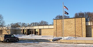
Stanton County is a county in the U.S. state of Nebraska. As of the 2020 United States Census, the population was 5,842. Its county seat is Stanton. The county was formed in 1856 and organized in 1867. It was first called Izard County until 1862, when it was renamed for Edwin M. Stanton, Secretary of War during the administration of President Abraham Lincoln.

<span class="mw-page-title-main">Sheridan County, Nebraska</span> County in Nebraska, United States

Sheridan County is a county in the U.S. state of Nebraska. As of the 2020 United States Census, the population was 5,127. Its county seat is Rushville. The county was formed in 1885, and was named for General Philip H. Sheridan.

<span class="mw-page-title-main">Seward County, Nebraska</span> County in Nebraska, United States

Seward County is a county in the U.S. state of Nebraska, United States. As of the 2020 United States Census, the population was 17,609. Its county seat is Seward. The county was formed in 1855, and was organized in 1867. It was originally called Greene County, and in 1862 it was renamed for William H. Seward, Secretary of State under Abraham Lincoln and Andrew Johnson. Seward County is part of the Lincoln, NE Metropolitan Statistical Area.

<span class="mw-page-title-main">Scotts Bluff County, Nebraska</span> County in Nebraska, United States

Scotts Bluff County is a county on the western border of the U.S. state of Nebraska. As of the 2020 United States Census, the population was 36,084. Its county seat is Gering, and its largest city is Scottsbluff.

<span class="mw-page-title-main">Saunders County, Nebraska</span> County in Nebraska, United States

Saunders County is a county in the U.S. state of Nebraska. As of the 2020 United States Census, the population was 22,278. Its county seat is Wahoo.

<span class="mw-page-title-main">Richardson County, Nebraska</span> County in Nebraska, United States

Richardson County is the easternmost county in the U.S. state of Nebraska. As of the 2020 census, the population was 7,871. Its county seat is Falls City.

<span class="mw-page-title-main">Pierce County, Nebraska</span> County in Nebraska, United States

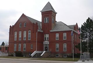
Pierce County is a county in the U.S. state of Nebraska. As of the 2020 United States Census, the population was 7,317. Its county seat is Pierce. The county was formed in 1859, and was named for US President Franklin Pierce.

<span class="mw-page-title-main">Phelps County, Nebraska</span> County in Nebraska, United States

Phelps County is a county in the U.S. state of Nebraska. As of the 2020 United States Census, the population was 8,968. Its county seat is Holdrege. The county was formed in 1873, and was named for William Phelps (1808–1889), a steamboat captain and early settler.

<span class="mw-page-title-main">Lincoln County, Nebraska</span> County in Nebraska, United States

Lincoln County is a county located in the U.S. state of Nebraska. As of the 2020 census, the population was 34,676. Its county seat is North Platte. Despite the county's name, the state capital city of Lincoln is not in or near Lincoln County.

<span class="mw-page-title-main">Knox County, Nebraska</span> County in Nebraska, United States

Knox County is a county in the U.S. state of Nebraska. As of the 2020 United States Census, the population was 8,391. Its county seat is Center. Knox County was named for Continental and U.S. Army Major General Henry Knox.

<span class="mw-page-title-main">Kimball County, Nebraska</span> County in Nebraska, United States

Kimball County is a county in the U.S. state of Nebraska. As of the 2020 United States Census, the population was 3,434. Its county seat is Kimball. The county was formed in 1888 and named after railroad pioneer Thomas Lord Kimball.

<span class="mw-page-title-main">Keith County, Nebraska</span> County in Nebraska, United States

Keith County is a county in the U.S. state of Nebraska. As of the 2020 United States Census, the population was 8,335. Its county seat is Ogallala.

<span class="mw-page-title-main">Kearney County, Nebraska</span> County in Nebraska, United States

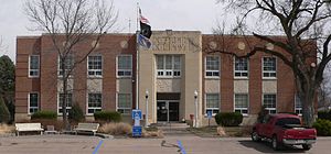
Kearney County is a county located in the U.S. state of Nebraska. As of the 2020 United States Census, the population was 6,688. Its county seat is Minden. The county was formed in 1860. It was named for Fort Kearny, which in turn was named for Brigade General Stephen W. Kearny.

<span class="mw-page-title-main">Jefferson County, Nebraska</span> County in Nebraska, United States

Jefferson County is a county in the U.S. state of Nebraska. As of the 2020 United States Census, the population was 7,240. Its county seat is Fairbury. The county was named for Thomas Jefferson, third President of the United States of America.

<span class="mw-page-title-main">Hall County, Nebraska</span> County in Nebraska, United States

Hall County is a county in the U.S. state of Nebraska. As of the 2020 United States Census, the population was 62,895, making it Nebraska's fourth-most populous county. Its county seat is Grand Island. The county was formed in 1858; it was named for Augustus Hall, an early judge of this territory.

<span class="mw-page-title-main">Gage County, Nebraska</span> County in Nebraska, United States

Gage County is a county in the U.S. state of Nebraska. As of the 2020 United States Census, the population was 21,704. Its county seat is Beatrice. The county was created in 1855 and organized in 1857. It was formed from land taken from the Otoe in an 1854 treaty. The county was named for William D. Gage, a Methodist minister who served as the first chaplain of the Nebraska Territorial Legislature.

<span class="mw-page-title-main">Frontier County, Nebraska</span> County in Nebraska, United States

Frontier County is a county in the U.S. state of Nebraska. As of the 2020 United States Census, the population was 2,519. Its county seat is Stockville.

<span class="mw-page-title-main">Dawson County, Nebraska</span> County in Nebraska, United States

Dawson County is a county in the U.S. state of Nebraska. As of the 2020 United States Census, the population was 24,111. Its county seat is Lexington.

<span class="mw-page-title-main">Cedar County, Nebraska</span> County in Nebraska, United States

Cedar County is a county in the U.S. state of Nebraska. As of the 2020 United States Census, the population was 8,380. The county seat is Hartington. The county was formed in 1857, and was named for the Cedar tree groves in the area.

References

  1. 1 2 "QuickFacts: Gosper County, Nebraska". United States Census Bureau. Retrieved September 12, 2021.
  2. "Find a County". National Association of Counties. Archived from the original on May 31, 2011. Retrieved June 7, 2011.
  3. Fitzpatrick, Lilian Linder (1925). Nebraska Place-Names. Lincoln: University of Nebraska Studies in Language, Literature, and Criticism. p. 67. Retrieved December 14, 2014.
  4. "Nebraska Historic Buildings Survey Reconnaissance Survey Final Report of Gosper County, Nebraska" (PDF). Nebraska State Historical Society. March 1, 1991. Archived from the original on November 16, 2006. Retrieved December 14, 2014.{{cite web}}: CS1 maint: unfit URL (link)
  5. "Gosper County". Nebraska Association of County Officials. Retrieved December 14, 2014.
  6. Gannett, Henry (1905). The Origin of Certain Place Names in the United States. Govt. Print. Off. p.  140.
  7. "2010 Census Gazetteer Files". US Census Bureau. August 22, 2012. Archived from the original on November 13, 2013. Retrieved December 7, 2014.
  8. Gosper National Wildlife Management Area, Bertrand NE Google Maps (accessed 21 January 2019)
  9. Johnson Lake State Recreation Area Google Maps (accessed 21 January 2019)
  10. Phillips Lake State Recreation Area, Smithfield NE Google Maps (accessed 21 January 2019)
  11. "US Decennial Census". US Census Bureau. Retrieved December 7, 2014.
  12. "Historical Census Browser". University of Virginia Library. Retrieved December 7, 2014.
  13. "Population of Counties by Decennial Census: 1900 to 1990". US Census Bureau. Retrieved December 7, 2014.
  14. "Census 2000 PHC-T-4. Ranking Tables for Counties: 1990 and 2000" (PDF). US Census Bureau. Archived (PDF) from the original on March 27, 2010. Retrieved December 7, 2014.
  15. "U.S. Census website". US Census Bureau. Retrieved January 31, 2008.
  16. Johnson Lake, Gosper County NE Google Maps (accessed 21 January 2019)
  17. "Dave Leip's Atlas of U.S. Presidential Elections".

40°30′N99°49′W / 40.50°N 99.82°W / 40.50; -99.82