Kimball County, Nebraska

Last updated

Kimball County
Kimball County Courthouse from N 2.JPG
Kimball County Courthouse in Kimball
Map of Nebraska highlighting Kimball County.svg
Location within the U.S. state of Nebraska
Nebraska in United States.svg
Nebraska's location within the U.S.
Coordinates: 41°12′N103°43′W / 41.2°N 103.71°W / 41.2; -103.71
CountryFlag of the United States.svg United States
StateFlag of Nebraska.svg  Nebraska
Founded1888
Seat Kimball
Largest cityKimball
Area
  Total952 sq mi (2,470 km2)
  Land952 sq mi (2,470 km2)
  Water0.6 sq mi (2 km2)  0.06%
Population
 (2020)
  Total3,434
  Density3.6/sq mi (1.4/km2)
Time zone UTC−7 (Mountain)
  Summer (DST) UTC−6 (MDT)
Congressional district 3rd
Website www.co.kimball.ne.us

Kimball County is a county in the U.S. state of Nebraska. As of the 2020 United States Census, the population was 3,434. [1] Its county seat is Kimball. [2] The county was formed in 1888 and named after railroad pioneer Thomas Lord Kimball. [3]

Contents

In the Nebraska license plate system, Kimball County is represented by the prefix 71 (it was the county having the seventy-first-largest number of vehicles registered in the state when the license plate system was established in 1922).

Geography

The terrain of Kimball County consists of rolling hills sloping to the east. The flatter portions are mainly used for agriculture, mostly dry farming with a modest amount of center pivot irrigation. A small drainage, Lodgepole Creek, feeds into the Oliver Reservoir, in the western central part of the county. [4] The county has a total area of 952 square miles (2,470 km2), of which 952 square miles (2,470 km2) is land and 0.6 square miles (1.6 km2) (0.06%) is water. [5] The highest natural point in Nebraska, Panorama Point at 5,424 feet (1,653 m), is located in Kimball County.

The FIPS code of Kimball county is 31105. [6]

Major highways

Adjacent counties

Protected areas

Demographics

Historical population
CensusPop.Note
1890 959
1900 758−21.0%
1910 1,942156.2%
1920 4,498131.6%
1930 4,6753.9%
1940 3,913−16.3%
1950 4,2839.5%
1960 7,97586.2%
1970 6,009−24.7%
1980 4,882−18.8%
1990 4,108−15.9%
2000 4,089−0.5%
2010 3,821−6.6%
2020 3,434−10.1%
2022 (est.)3,315−3.5%
US Decennial Census [8]
1790-1960 [9] 1900-1990 [10]
1990-2000 [11] 2010 [12] 2020 [13] 2022 [14]

As of the 2000 United States Census, [15] there were 4,089 people, 1,727 households, and 1,136 families in the county. The population density was 4 people per square mile (1.5 people/km2). There were 1,972 housing units at an average density of 2 units per square mile (0.77/km2). The racial makeup of the county was 96.99% White, 0.22% Black or African American, 0.66% Native American, 0.10% Asian, 0.02% Pacific Islander, 0.66% from other races, and 1.35% from two or more races. 3.33% of the population were Hispanic or Latino of any race. 34.3% were of German, 12.2% English, 7.9% Irish, 6.1% American and 5.5% Swedish ancestry.

There were 1,727 households, out of which 26.30% had children under the age of 18 living with them, 56.10% were married couples living together, 6.70% had a female householder with no husband present, and 34.20% were non-families. 30.50% of all households were made up of individuals, and 15.40% had someone living alone who was 65 years of age or older. The average household size was 2.33 and the average family size was 2.89.

The county population contained 24.70% under the age of 18, 5.90% from 18 to 24, 23.00% from 25 to 44, 25.30% from 45 to 64, and 21.00% who were 65 years of age or older. The median age was 43 years. For every 100 females, there were 95.60 males. For every 100 females age 18 and over, there were 91.20 males.

The median income for a household in the county was $30,586, and the median income for a family was $35,880. Males had a median income of $28,300 versus $16,863 for females. The per capita income for the county was $17,525. About 9.10% of families and 11.10% of the population were below the poverty line, including 12.30% of those under age 18 and 5.90% of those age 65 or over.

Communities

City

Villages

Unincorporated communities

Politics

Kimball County voters are reliably Republican. In only three national elections has the county selected the Democratic Party candidate.

United States presidential election results for Kimball County, Nebraska [16]
Year Republican Democratic Third party
No.%No.%No.%
2020 1,56383.27%26814.28%462.45%
2016 1,33079.31%23013.71%1176.98%
2012 1,23573.21%39523.41%573.38%
2008 1,34674.32%43924.24%261.44%
2004 1,49179.44%36619.50%201.07%
2000 1,37975.77%37920.82%623.41%
1996 1,01156.67%52729.54%24613.79%
1992 93152.04%40822.81%45025.15%
1988 1,32169.89%54028.57%291.53%
1984 1,73483.09%33916.24%140.67%
1980 1,61575.61%38518.02%1366.37%
1976 1,25762.82%69634.78%482.40%
1972 1,65079.06%43720.94%00.00%
1968 1,42368.61%41419.96%23711.43%
1964 1,57355.88%1,24244.12%00.00%
1960 2,15267.93%1,01632.07%00.00%
1956 1,59070.79%65629.21%00.00%
1952 1,64677.60%47522.40%00.00%
1948 1,02460.38%67239.62%00.00%
1944 1,16966.99%57633.01%00.00%
1940 1,19061.82%73538.18%00.00%
1936 84241.44%1,13755.95%532.61%
1932 79337.58%1,26860.09%492.32%
1928 1,29674.01%43825.01%170.97%
1924 75051.23%25317.28%46131.49%
1920 91070.05%33926.10%503.85%
1916 22334.36%38859.78%385.86%
1912 7317.85%10926.65%22755.50%
1908 21660.50%12434.73%174.76%
1904 14380.34%2011.24%158.43%
1900 13772.11%4825.26%52.63%

See also

Related Research Articles

<span class="mw-page-title-main">Fall River County, South Dakota</span> County in South Dakota, United States

Fall River County is a county in the U.S. state of South Dakota. As of the 2020 census, the population was 6,973. Its county seat is Hot Springs. The county was founded in 1883. It is named for Fall River which runs through it.

<span class="mw-page-title-main">Webster County, Nebraska</span> County in Nebraska, United States

Webster County is a county in the U.S. state of Nebraska. As of the 2020 United States Census, the population was 3,411. Its county seat is Red Cloud. The county was formed in 1871, and was named for Daniel Webster.

<span class="mw-page-title-main">Sioux County, Nebraska</span> County in Nebraska, United States

Sioux County is a county in the U.S. state of Nebraska. As of the 2020 United States Census, the population was 1,135. Its county seat is Harrison.

<span class="mw-page-title-main">Sheridan County, Nebraska</span> County in Nebraska, United States

Sheridan County is a county in the U.S. state of Nebraska. As of the 2020 United States Census, the population was 5,127. Its county seat is Rushville. The county was formed in 1885, and was named for General Philip H. Sheridan.

<span class="mw-page-title-main">Scotts Bluff County, Nebraska</span> County in Nebraska, United States

Scotts Bluff County is a county on the western border of the U.S. state of Nebraska. As of the 2020 United States Census, the population was 36,084. Its county seat is Gering, and its largest city is Scottsbluff.

<span class="mw-page-title-main">Saline County, Nebraska</span> County in Nebraska, United States

Saline County is a county in the U.S. state of Nebraska. As of the 2020 United States Census, the population was 14,292. Its county seat is Wilber.

<span class="mw-page-title-main">Pierce County, Nebraska</span> County in Nebraska, United States

Pierce County is a county in the U.S. state of Nebraska. As of the 2020 United States Census, the population was 7,317. Its county seat is Pierce. The county was formed in 1859, and was named for US President Franklin Pierce.

<span class="mw-page-title-main">Howard County, Nebraska</span> County in Nebraska, United States

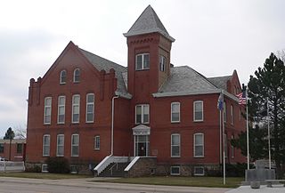
Howard County is a county in the state of Nebraska. As of the 2020 United States Census, the population was 6,475. Its county seat is St. Paul. The county was formed in 1871 and named after Civil War General Oliver Otis Howard.

<span class="mw-page-title-main">Gage County, Nebraska</span> County in Nebraska, United States

Gage County is a county in the U.S. state of Nebraska. As of the 2020 United States Census, the population was 21,704. Its county seat is Beatrice. The county was created in 1855 and organized in 1857. It was formed from land taken from the Otoe in an 1854 treaty. The county was named for William D. Gage, a Methodist minister who served as the first chaplain of the Nebraska Territorial Legislature.

<span class="mw-page-title-main">Frontier County, Nebraska</span> County in Nebraska, United States

Frontier County is a county in the U.S. state of Nebraska. As of the 2020 United States Census, the population was 2,519. Its county seat is Stockville.

<span class="mw-page-title-main">Deuel County, Nebraska</span> County in Nebraska, United States

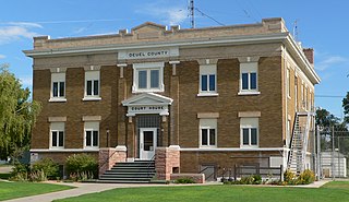
Deuel County is a county located in the U.S. State of Nebraska. As of the 2020 United States Census, the population was 1,838. Its county seat is Chappell. The county was formed in 1889 and named for Harry Porter Deuel, superintendent of the Union Pacific Railroad.

<span class="mw-page-title-main">Dawes County, Nebraska</span> County in Nebraska, United States

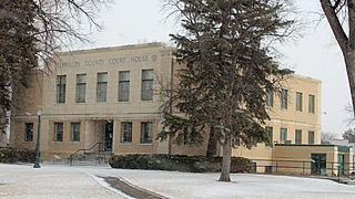
Dawes County is a county in the U.S. state of Nebraska. As of the 2020 United States Census, the population was 8,199. Its county seat is Chadron. The county was formed in 1885; it was named for James W. Dawes, the Nebraska Governor at the time.

<span class="mw-page-title-main">Cheyenne County, Nebraska</span> County in Nebraska, United States

Cheyenne County is a county in the U.S. state of Nebraska. As of the 2020 United States Census, the population was 9,468. Its county seat is Sidney. The county was formed in 1871 and named for the Cheyenne Native American tribe.

<span class="mw-page-title-main">Box Butte County, Nebraska</span> County in Nebraska, United States

Box Butte County is a county in the U.S. state of Nebraska. As of the 2020 United States Census, the population was 10,842. Its county seat is Alliance. The county was formed in 1886; it took its name from a large box-shaped butte north of Alliance.

<span class="mw-page-title-main">Banner County, Nebraska</span> County in Nebraska, United States

Banner County is a county in the western part of the U.S. state of Nebraska in the Great Plains region of the United States. As of the 2020 United States Census, its population was 674. Its county seat is the unincorporated community of Harrisburg; there are no incorporated municipalities within the county.

<span class="mw-page-title-main">Phillips County, Colorado</span> County in Colorado, United States

Phillips County is a county located in the U.S. state of Colorado. As of the 2020 census, the population was 4,530. The county seat is Holyoke. The county was named in honor of R.O. Phillips, a secretary of the Lincoln Land Company, who organized several towns in Colorado.

<span class="mw-page-title-main">Otero County, Colorado</span> County in Colorado, United States

Otero County is a county located in the U.S. state of Colorado. As of the 2020 census, the population was 18,690. The county seat is La Junta. The county was named for Miguel Antonio Otero, one of the founders of the town of La Junta and a member of a prominent Hispanic family.

<span class="mw-page-title-main">Logan County, Colorado</span> County in Colorado, United States

Logan County is a county located in the U.S. state of Colorado. As of the 2020 census, the population was 21,528. The county seat is Sterling. The county was named for General John A. Logan.

<span class="mw-page-title-main">Dix, Nebraska</span> Village in Kimball County, Nebraska, United States

Dix is a village in Kimball County, Nebraska, United States. The population was 255 at the 2010 census.

<span class="mw-page-title-main">Kimball, Nebraska</span> City in and county seat of Kimball County, Nebraska, United States

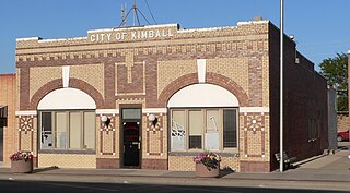
Kimball is a city in and county seat of Kimball County, Nebraska, United States. The population was 2,290 at the 2020 census.

References

  1. "Kimball County, Nebraska". United States Census Bureau . Retrieved June 19, 2023.
  2. "Find a County". National Association of Counties. Archived from the original on May 31, 2011. Retrieved June 7, 2011.
  3. "Kimball County". Archived from the original on July 4, 2008. Retrieved March 25, 2010.
  4. Kimball County NE Google Maps (accessed 23 January 2019)
  5. "2010 Census Gazetteer Files". US Census Bureau. August 22, 2012. Archived from the original on November 13, 2013. Retrieved December 8, 2014.
  6. Archived March 12, 2016, at the Wayback Machine US Census Bureau
  7. Oliver State Recreation Area, Kimball NE Google Maps (accessed 23 January 2019)
  8. "US Decennial Census". US Census Bureau. Retrieved December 8, 2014.
  9. "Historical Census Browser". University of Virginia Library. Retrieved December 8, 2014.
  10. "Population of Counties by Decennial Census: 1900 to 1990". US Census Bureau. Retrieved December 8, 2014.
  11. "Census 2000 PHC-T-4. Ranking Tables for Counties: 1990 and 2000" (PDF). US Census Bureau. Archived (PDF) from the original on March 27, 2010. Retrieved December 8, 2014.
  12. https://www.census.gov/quickfacts/fact/table/kimballcountynebraska/PST045222.{{cite web}}: Missing or empty |title= (help)
  13. "Kimball County, Nebraska". United States Census Bureau . Retrieved June 19, 2023.
  14. "State & County QuickFacts". US Census Bureau. Archived from the original on June 7, 2011. Retrieved September 21, 2013.
  15. "U.S. Census website". United States Census Bureau . Retrieved January 31, 2008.
  16. Election Results

41°12′N103°43′W / 41.20°N 103.71°W / 41.20; -103.71