
Yarnell is a census-designated place (CDP) in Yavapai County, Arizona, United States. The population of Yarnell was 649 at the 2010 census. Yarnell's economy is based on ranching, mining and services to travelers and retirees. Peeples Valley, three miles north, is closely linked to Yarnell.

Stone Mountain is a quartz monzonite dome monadnock and the site of Stone Mountain Park, 16 miles (26 km) east of Atlanta, Georgia. Outside the park is the small city of Stone Mountain, Georgia. The park is the most visited tourist site in the state of Georgia.

Multnomah Falls is a waterfall located on Multnomah Creek in the Columbia River Gorge, east of Troutdale, between Corbett and Dodson, Oregon, United States. The waterfall is accessible from the Historic Columbia River Highway and Interstate 84. Spanning two tiers on basalt cliffs, it is the tallest waterfall in the state of Oregon at 620 ft (189 m) in height. The Multnomah Creek Bridge, built in 1914, crosses below the falls, and is listed on the National Register of Historic Places.

Mount Katahdin is the highest mountain in the U.S. state of Maine at 5,269 feet (1,606 m). Named Katahdin, which means "Great Mountain", by the Penobscot Native Americans, it is within Northeast Piscataquis, Piscataquis County, and is the centerpiece of Baxter State Park. It is a steep, tall massif formed from a granite intrusion weathered to the surface. The flora and fauna on the mountain are typical of those found in northern New England, with the summit hosting fragile and endangered alpine tundra.

Morrow Mountain State Park is a state park in Stanly County, North Carolina, U.S. Located near Albemarle, the park includes 5,881 acres (23.80 km2) within the Uwharrie Mountains.
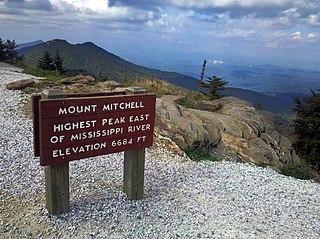
Mount Mitchell State Park is a 4,789-acre (1,938 ha) North Carolina state park in Yancey County, North Carolina in the United States. Established in 1915 by the state legislature, it became the first state park of North Carolina. By doing so, it also established the North Carolina State Parks System within the same bill.

Old Rag Mountain is a 3,284 feet (1,001 m) mountain near Sperryville in Madison County, Virginia. A part of the Blue Ridge Mountains, the peak is located within Shenandoah National Park and is the most popular hiking destination within the park.
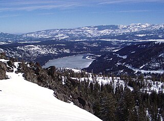
Donner Memorial State Park is a state park of California, US, preserving the site of the Donner Camp, where members of the ill-fated Donner Party were trapped by weather during the winter of 1846–1847. Caught without shelter or adequate supplies, members of the group resorted to cannibalism to survive. The Sierra Nevada site has been designated a National Historic Landmark. The state park contains the Emigrant Trail Museum and the Pioneer Monument dedicated to the travelers of the Emigrant Trail.

Catalina State Park is located at the base of the Santa Catalina Mountains. It is home to nearly 5,000 saguaros and desert plants. There are 5,500 acres of foothills and canyons that offer opportunities for camping, hiking, and bird watching. The park is home to more than 150 species. At an elevation of nearly 3,000 feet, the park offers miles of trails for recreational use.

Blue Knob State Park is a 6,128-acre (2,480 ha) Pennsylvania state park in Kimmel, Lincoln, and Pavia townships in Bedford County, Pennsylvania, in the United States. The average annual snowfall at the park is about 12 feet (370 cm). The park is named for Blue Knob, the second highest mountain in Pennsylvania at 3,146 feet (959 m). It is the location of Blue Knob All Seasons Resort, the ski slope in Pennsylvania with the highest elevation. Blue Knob State Park is just off Interstate 99 on Pennsylvania Route 869 west of Pavia.

In the United States, a Shot Crew, officially known as an Interagency Hotshot Crew (IHC), is a team of 20-22 elite wildland firefighters that mainly respond to large, high-priority fires across the country and abroad. They are assigned to work the most challenging parts of the fire and are considered strategic and tactical wildland fire experts. Hotshot crews are considered the most highly trained, skilled and experienced wildland firefighters, along with smokejumpers. They are qualified to provide leadership for initial-attack and extended-attack on wildland fires. Hotshots are trained and equipped to work in remote areas for extended periods of time with minimal logistical support. They are organized by agencies such as the United States Forest Service, National Park Service, Bureau of Indian Affairs, Bureau of Land Management, and state/county agencies; the National Interagency Fire Center coordinates hotshot crews on the federal level.

Curt Gowdy State Park is a public recreation area covering 3,395 acres in Albany and Laramie counties in Wyoming, United States. It is located on Wyoming Highway 210, halfway between Cheyenne and Laramie, about 24 miles (40 km) from each. The state park is known for its extensive trail system, fishing reservoirs, and Hynds Lodge, which is listed on the National Register of Historic Places. The park is managed by the Wyoming Division of State Parks and Historic Sites.

Tully Mountain, 1,163 ft (354 m), is a prominent, steep-sided monadnock located in north central Massachusetts in the town of Orange. It is part of the Tully Mountain Wilderness Management Area. An exposed east facing ledge on the summit provides views of the Millers River valley, Mount Monadnock, Mount Wachusett, and the Wapack Range. The 22-mile (35 km) Tully Trail traverses the mountain.

Lost Dutchman State Park is a 320-acre (129 ha) state park located in northwestern Pinal County, Arizona on the Apache Trail north of Apache Junction, near the Superstition Mountains in central Arizona. It is named after the Lost Dutchman's Gold Mine, a famously lost gold mine legendary in the tales of the Old West. It is accessible about 40 miles (64 km) east of Phoenix via U.S. Highway 60, the Superstition Freeway.

The Prescott Public Library is the public library in Prescott, Arizona.

The Yarnell Hill Fire was a wildfire near Yarnell, Arizona, ignited by dry lightning on June 28, 2013. On June 30, it overran and killed 19 members of the Granite Mountain Hotshots. Just one of the hotshots on the crew survived—he was posted as a lookout on the fire and was not with the others when the fire overtook them. The Yarnell Hill Fire was one of the deadliest U.S. wildfires since the 1991 Oakland Hills fire, which killed 25 people, and the deadliest wildland fire for U.S. firefighters since the 1933 Griffith Park fire, which killed 29 "impromptu" civilian firefighters drafted on short notice to help battle that Los Angeles area fire.

The Prescott Fire Department is the municipal fire department for the city of Prescott, Arizona. Additionally, the PFD provides aircraft rescue and firefighting for the Prescott Municipal Airport. Founded in 1885, it is the oldest fire department in the state of Arizona. With a coverage area of 41.5 square miles (107 km2) and serving a population of 39,843, the PFD consists of 92 career personnel, split among five fire stations.
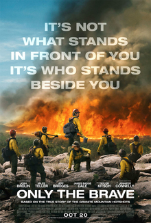
Only the Brave, originally titled Granite Mountain and subtitled as Only the Brave: The True Story of the Granite Mountain Hotshots in previews, is a 2017 American biographical drama film directed by Joseph Kosinski, and written by Ken Nolan and Eric Warren Singer, based on the GQ article "No Exit" by Sean Flynn. The film tells the story of the Granite Mountain Hotshots, an elite crew of firefighters from Prescott, Arizona who lost 19 of 20 members while fighting the Yarnell Hill Fire in June 2013, and is dedicated to their memory. It features an ensemble cast, including Josh Brolin, James Badge Dale, Jeff Bridges, Miles Teller, Alex Russell, Taylor Kitsch, Ben Hardy, Thad Luckinbill, Geoff Stults, Scott Haze, Andie MacDowell, and Jennifer Connelly.

Underhill State Park is a state park in Underhill, Vermont. It is situated on the west slope of 4,300 feet Mount Mansfield, in the 39,837-acre Mount Mansfield State Forest. Activities includes hiking, camping, mountain biking, stream fishing, wildlife watching, and picnicking. Facilities include group and individual camping areas, a picnic shelter, and hiking trails. The park is formally open between Memorial Day weekend and Columbus Day weekend, but is accessible for periods outside those times; fees are charged. Much of the park's infrastructure was built by the Civilian Conservation Corps (CCC) in the 1930s; these facilities were listed on the National Register of Historic Places in 2002.

