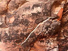
A petroglyph is an image created by removing part of a rock surface by incising, picking, carving, or abrading, as a form of rock art. Outside North America, scholars often use terms such as "carving", "engraving", or other descriptions of the technique to refer to such images. Petroglyphs, estimated to be 20,000 years old and classified as protected monuments and have been added to the tentative list of UNESCO’s world heritage sites. Petroglyphs are found worldwide, and are often associated with prehistoric peoples. The word comes from the Greek prefix petro-, from πέτρα petra meaning "stone", and γλύφω glýphō meaning "carve", and was originally coined in French as pétroglyphe.

Bandelier National Monument is a 33,677-acre (13,629 ha) United States National Monument near Los Alamos in Sandoval and Los Alamos counties, New Mexico. The monument preserves the homes and territory of the Ancestral Puebloans of a later era in the Southwest. Most of the pueblo structures date to two eras, dating between 1150 and 1600 AD.

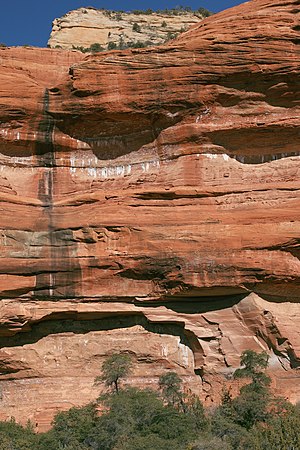
Northern Arizona is an unofficial, colloquially-defined region of the U.S. state of Arizona. Generally consisting of Apache, Coconino, Mohave, Navajo, and Gila counties, the region is geographically dominated by the Colorado Plateau, the southern border of which in Arizona is called the Mogollon Rim.

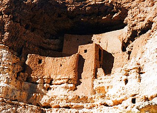
Walnut Canyon National Monument is a United States National Monument located about 10 mi (16 km) southeast of downtown Flagstaff, Arizona, near Interstate 40. The canyon rim elevation is 6,690 ft (2,040 m); the canyon's floor is 350 ft lower. A 0.9 mi (1.4 km) long loop trail descends 185 ft (56 m) into the canyon passing 25 cliff dwelling rooms constructed by the Sinagua, a pre-Columbian cultural group that lived in Walnut Canyon from about 1100 to 1250 AD. Other contemporary habitations of the Sinagua people are preserved in the nearby Tuzigoot and Montezuma Castle national monuments.

Navajo National Monument is a National Monument located within the northwest portion of the Navajo Nation territory in northern Arizona, which was established to preserve three well-preserved cliff dwellings of the Ancestral Puebloan people: Keet Seel, Betatakin, and Inscription House. The monument is high on the Shonto plateau, overlooking the Tsegi Canyon system, west of Kayenta, Arizona. It features a visitor center with a museum, three short self-guided trails, two small campgrounds, and a picnic area.
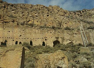
The Puye Cliff Dwellings are the ruins of an abandoned pueblo, located in Santa Clara Canyon on Santa Clara Pueblo land near Española, New Mexico. The site was declared a National Historic Landmark in 1966.
In archaeology, cliff dwellings are dwellings formed by using niches or caves in high cliffs, and sometimes with excavation or additions in the way of masonry.

The Sinagua were a pre-Columbian culture that occupied a large area in central Arizona from the Little Colorado River, near Flagstaff, to the Verde River, near Sedona, including the Verde Valley, area around San Francisco Mountain, and significant portions of the Mogollon Rim country, between approximately 500 and 1425 CE.
Tsankawi is a detached portion of Bandelier National Monument in New Mexico, near White Rock. It is accessible from a roadside parking area just north of the intersection of East Jemez Road and State Road 4. A self-guided 1.5-mile loop trail provides access to numerous unexcavated ruins, caves carved into soft tuff, and petroglyphs.
The V Bar V Heritage Site is the largest known petroglyph site in the Verde Valley of central Arizona, and one of the best-preserved. The rock art site consists of 1,032 petroglyphs in 13 panels. Acquired by the Coconino National Forest in 1994, the site is protected and kept open to the public by the US Forest Service. Volunteers from the Verde Valley Archaeological Society and the Friends of the Forest provide interpretive tours and on-site management.

Elden Pueblo was a prehistoric Native American village located at the foot of Mount Elden near Flagstaff, Arizona. The pueblo is thought to have been part of a major trading system. Various trade items such as macaw skeletons from Mexico as well as shell jewelry from the coast of California have been found throughout the site. The area is now protected and is used for research and educational purposes.

The Trail of the Ancients is a collection of National Scenic Byways located in the U.S. Four Corners states of Utah, Colorado, New Mexico, and Arizona. These byways comprise:

The Honanki Heritage Site is a cliff dwelling and rock art site located in the Coconino National Forest, about 15 miles (24 km) west of Sedona, Arizona. The Sinagua people of the Ancestral Puebloans, and ancestors of the Hopi people, lived here from about 1100 to 1300 CE. The Palatki Heritage Site is nearby, also in the Coconino National Forest.

Hundreds of Ancestral Puebloan dwellings are found across the American Southwest. With almost all constructed well before 1492 CE, these Puebloan towns and villages are located throughout the geography of the Southwest.

Picture Canyon, located in the Comanche National Grassland in southeastern Colorado, was named for its prehistoric rock art. There is evidence of prehistoric inhabitation of sites in Picture Canyon by Paleo-Indian, Archaic and Post-Archaic cultures, from about 12,000 years ago to 400 years ago. In addition to rock art, there are also carvings in walls that are used to identify the entry into fall and spring equinoxes.
Pink Jeep Tours is a passenger tour operator that offers off-road and road-based excursions to various destinations across the American Southwest, with locations in Sedona Las Vegas, Pigeon Forge, and the Grand Canyon. The company has been in operation since 1960. Pink Jeep Tours is especially known for its tour of the Broken Arrow trail in Sedona, and it is the only tour operator permitted by the United States Forest Service to use the trail.

Puerco Ruin and Petroglyphs are the ruins of a large Indian pueblo, which reached its peak around 1300 CE, containing over 100 rooms. It is the largest known archeological site within the Petrified Forest National Park.

The Dark Canyon Ruins are a collection of ancient Puebloan ruins in southeastern Utah found in Dark Canyon Wilderness, part of Bears Ears National Monument. At least 72 archaeological sites have been identified in the Beef Basin-Dark Canyon Plateau area. The ruins mostly consist of cliff dwellings, ceramics, and petroglyph art. Ceramic collections in the area indicate that the structures may have been occupied during the Pueblo II and Pueblo III periods. However, there is evidence of earlier human habitation in the canyons by the Pueblo/Anasazi, starting in 600 CE. Most of the ruins are cliff houses or storerooms, with the region abandoned around 1300 CE. Later, other native groups like the Ute and Navajo moved into the region, although they did not significantly contribute the structures.