
A swamp is a forested wetland. Swamps are considered to be transition zones because both land and water play a role in creating this environment. Swamps vary in size and are located all around the world. The water of a swamp may be fresh water, brackish water, or seawater. Freshwater swamps form along large rivers or lakes where they are critically dependent upon rainwater and seasonal flooding to maintain natural water level fluctuations. Saltwater swamps are found along tropical and subtropical coastlines. Some swamps have hammocks, or dry-land protrusions, covered by aquatic vegetation, or vegetation that tolerates periodic inundation or soil saturation. The two main types of swamp are "true" or swamp forests and "transitional" or shrub swamps. In the boreal regions of Canada, the word swamp is colloquially used for what is more formally termed a bog, fen, or muskeg. Some of the world's largest swamps are found along major rivers such as the Amazon, the Mississippi, and the Congo.

Gates County is a county located in the northeastern portion of the U.S. state of North Carolina, on the border with Virginia. As of the 2020 census, the population was 10,478, making it the fifth-least populous county in North Carolina. Its county seat is Gatesville. Gates County is included in the Virginia Beach-Chesapeake, VA-NC Combined Statistical Area. It is part of the Albemarle Sound area of the Inner Banks.

Big Lake National Wildlife Refuge is an 11,047-acre (45 km2) National Wildlife Refuge located in Mississippi County, Arkansas, managed by the United States Fish and Wildlife Service. It is situated 2 miles (3.2 km) east of Manila, Arkansas, and consists mostly of a shallow lake, swamp, and bottomland hardwood forests. The preservation of habitat for waterfowl in an intensely agricultural region is the primary purpose of the refuge. 6,400 acres (20 km2) of Big Lake is classified as a National Natural Landmark and 2,144 acres (8 km2) are classified as wilderness.

Pettigrew State Park is a North Carolina State Park in Tyrrell and Washington Counties, North Carolina in the United States. It covers 5,951 acres (24.08 km2) around the shore lines of Lake Phelps and the Scuppernong River. The park's developed facilities are south of U.S. Route 64 near Roper and Creswell, North Carolina. Pettigrew State Park is open for year-round recreation, including hiking, camping, fishing, boating and picnicking.

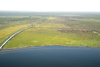
The Great Dismal Swamp is a large swamp in the Coastal Plain Region of southeastern Virginia and northeastern North Carolina, between Norfolk, Virginia, and Elizabeth City, North Carolina. It is located in parts of the southern Virginia independent cities of Chesapeake and Suffolk and northern North Carolina counties of Gates, Pasquotank, and Camden. Some estimates place the original size of the swamp at over one million acres (4,000 km2). As of 2022 the size of the Great Dismal Swamp is around 750 square miles.

Lake Drummond is a freshwater lake at the center of the Great Dismal Swamp, a marshy region on the Coastal Plain of southeastern Virginia and northeastern North Carolina between Norfolk, Virginia, and Elizabeth City, North Carolina, in the United States. Its surface area is approximately 3,142 acres (13 km2) and its maximum depth is 6 ft (2 m). It is managed by the United States Fish and Wildlife Service.

The Arthur R. Marshall Loxahatchee National Wildlife Refuge is a 145,188-acre (587.55 km2) wildlife sanctuary is located west of Boynton Beach, in Palm Beach County, Florida. It is also known as Water Conservation Area 1 (WCA-1). It includes the most northern remnant of the historic Everglades wetland ecosystem.

The Dismal Swamp Canal is a canal located along the eastern edge of the Great Dismal Swamp in Virginia and North Carolina in the United States. Opened in 1805, it is the oldest continually operating man-made canal in the United States. It is part of the Intracoastal Waterway.

False Cape State Park is a 4,321-acre (17.49 km2) state park located on the Currituck Banks Peninsula, a one-mile-wide (1.6 km) barrier spit between the Back Bay of the Currituck Sound and the Atlantic Ocean, within the city of Virginia Beach, adjacent to the state border with North Carolina, and just north of Mackay Island National Wildlife Refuge.

The Scuppernong River is a blackwater river that flows through Tyrrell County and Washington County, North Carolina, into the Albemarle Sound. The river shares its name with the Scuppernong grapes native to the area. The river has a history closely linked to colonization and agricultural utilization. Currently, the Pocosin Lakes National Wildlife Refuge and Pettigrew State Park can be found on the banks of the river. The River is celebrated annually through the Scuppernong River Festival.

The Okefenokee National Wildlife Refuge is a 402,000‑acre (1,627 km2) National Wildlife Refuge located in Charlton, Ware, and Clinch Counties of Georgia, and Baker County in Florida, United States. The refuge is administered from offices in Folkston, Georgia. The refuge was established in 1937 to protect a majority of the 438,000 acre (1,772 km2) Okefenokee Swamp. Though often translated as "land of trembling earth", the name "Okefenokee" is likely derived from Hitchiti oki fanôːki "bubbling water".
The Alligator River National Wildlife Refuge is a 152,000-acre (620 km2) National Wildlife Refuge located in eastern North Carolina along the Atlantic Coast. It was established on March 14, 1984, to preserve and protect a unique wetland habitat type—the pocosin—and its associated wildlife species.

The Mingo National Wildlife Refuge is a 21,676-acre (87.7-km2) National Wildlife Refuge located in northwestern Stoddard and southeastern Wayne counties in Missouri. Its southwesternmost portion lies on the shores of Lake Wappapello. Named after the Mingo tribe, it was established to preserve bottomland hardwoods and provide waterfowl and other migratory birds in the Mississippi Flyway with nesting, feeding, brooding, and resting habitat.

Deep Creek is a former unincorporated town of the former Norfolk County (extinct) which since 1963 has been located in the independent city of Chesapeake in the South Hampton Roads region of southeastern Virginia. Deep Creek is located on the original route of U.S. Highway 17, on a section now designated as U.S. Route 17 Business, and has been largely bypassed by modern highway improvements.

The Croatan National Forest is a U.S. National Forest, was established on July 29, 1936, and is located on the Atlantic coast of North Carolina. It is administered by the United States Forest Service, a part of the United States Department of Agriculture. The forest is managed together with the other three North Carolina National Forests from common headquarters in Asheville, North Carolina. However, Croatan has a local ranger district office in New Bern.

The Great Loop is a system of waterways that encompasses the eastern portion of the United States and part of Canada. It is made up of both natural and man-made waterways, including the Atlantic and Gulf Intracoastal Waterways, the Great Lakes, the Erie Canal, and the Mississippi and Tennessee-Tombigbee Waterway. The entire loop stretches about 6,000 miles (9,700 km).
Cavalier Wildlife Management Area is a 4,550-acre (18.4 km2) Wildlife Management Area in Chesapeake, Virginia. It preserves habitat for a number of species, including black bear, canebrake rattlesnakes, white-tailed deer, eastern wild turkeys, and many varieties of songbirds.
The Atchafalaya National Wildlife Refuge is located about 30 miles (48 km) west of Baton Rouge, Louisiana, and one mile (1.6 km) east of Krotz Springs, Louisiana, lies just east of the Atchafalaya River. In 1988 under the administration of Governor Foster the "Atchafalaya Basin Master Plan" was implemented that combined the 11,780-acre (4,770 ha) Sherburne Wildlife Management Area (WMA), the 15,220-acre (6,160 ha) Atchafalaya National Wildlife Refuge, and the 17,000-acre (6,900 ha) U.S. Army Corps of Engineers' Bayou Des Ourses into the Sherburne Complex Wildlife Management Area.

Dismal Swamp State Park is a North Carolina state park in Camden County, North Carolina, in the United States. The park was created as a state natural area in 1974 with the help of The Nature Conservancy, and on July 28, 2007, the North Carolina General Assembly re-designated it as a state park. It opened to the public in 2008. This marked the first time that public access to Great Dismal Swamp was made possible in North Carolina. The park covers 14,432 acres (58.40 km2) of protected land on the North Carolina/Virginia border. Park offices are 3 miles (4.8 km) south of the border on U.S. Route 17 near South Mills. Features of the park include the canal which is used regularly by boaters using the Intracoastal Waterway and several miles of hiking and biking trails.
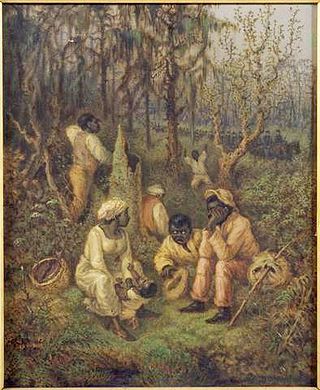
The Great Dismal Swamp maroons were people who inhabited the swamplands of the Great Dismal Swamp in Virginia and North Carolina after escaping enslavement. Although conditions were harsh, research suggests that thousands lived there between about 1700 and the 1860s. Harriet Beecher Stowe told the maroon people's story in her 1856 novel Dred: A Tale of the Great Dismal Swamp. The most significant research on the settlements began in 2002 with a project by Dan Sayers of American University.


