Deception Pass is a strait separating Whidbey Island from Fidalgo Island, in the northwest part of the U.S. state of Washington. It connects Skagit Bay, part of Puget Sound, with the Strait of Juan de Fuca. A pair of bridges known collectively as Deception Pass Bridge cross Deception Pass. The bridges were added to the National Register of Historic Places in 1982.

Georgetown County is a county located in the U.S. state of South Carolina. As of the 2020 census, the population was 63,404. Its county seat is Georgetown. The county was founded in 1769. It is named for George III of the United Kingdom.
New Hanover County is one of 100 counties located in the U.S. state of North Carolina. As of the 2020 census, the population was 225,702. Though the second-smallest NC county in land area, it is one of the most populous, as its county seat, Wilmington, is one of the state's largest cities. The county was created in 1729 as New Hanover Precinct and gained county status in 1739. New Hanover County is included in the Wilmington, NC Metropolitan Statistical Area, which also includes neighboring Pender County.

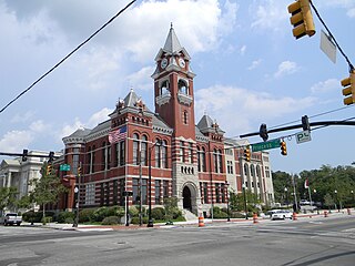
Carteret County is located in the U.S. state of North Carolina. As of the 2020 Census, the population was 67,686. Its county seat is Beaufort. The county was created in 1722 as Carteret Precinct and gained county status in 1739. It was named for Sir George Carteret, one of the 17th century English Lords Proprietor, or for his descendant and heir John Carteret, 2nd Earl Granville.

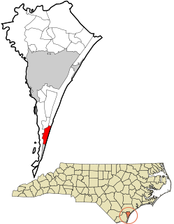
Wrightsville Beach is a town in New Hanover County, North Carolina, United States. Wrightsville Beach is just east of Wilmington and is part of the Wilmington Metropolitan Statistical Area. The population was 2,477 at the 2010 census. The town consists of a 4-mile (6 km) long beach island, an interior island called Harbor Island, and pockets of commercial property on the mainland. It served as a filming location of Dawson's Creek.

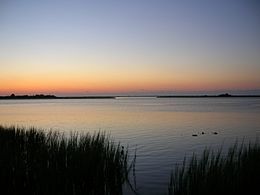
Biscayne Bay is a lagoon, with characteristics of an estuary, located on the Atlantic coast of South Florida, United States. The northern end of the lagoon is surrounded by the densely developed heart of the Miami metropolitan area, while the southern end is largely undeveloped, with a large portion of the lagoon included in Biscayne National Park. Sources differ on the extent of the lagoon. The part of the lagoon that is traditionally called "Biscayne Bay" is approximately 35 miles (56 km) long and up to 8 miles (13 km) wide, with a surface area of 221 square miles (570 km2). Various definitions may include Dumfoundling Bay, Card Sound, and Barnes Sound in a larger "Biscayne Bay", which is 60 miles (97 km) long, with a surface area of about 271 square miles (700 km2).

Hammocks Beach State Park is a North Carolina state park in Onslow County, North Carolina in the United States. Located near Swansboro, along the Southern Outer Banks, or Crystal Coast, the state park covers 1,611 acres (6.52 km2) and consists mainly of Bear Island. The park also owns three smaller islands, Dudley, Huggins and Jones, located in the nearby mouth of the White Oak River. After a recently completed deal, 319 acres (1.29 km2) acres on the mainland were added to the park.

Jupiter Island is a barrier island on the coast of Martin and Palm Beach counties, Florida. It is bounded on the east by the Atlantic Ocean, on the north by the St. Lucie Inlet, on the west by the Indian River, and on the south by the Jupiter Inlet. Jupiter Island originally was two islands, Long Island on the north and Jupiter Island on the south, which were once separated by an inlet in the vicinity of North Jupiter Narrows and what is officially called Peck Lake, but commonly called Peck's Lake.

Portsmouth was a fishing and shipping village located on Portsmouth Island on the Outer Banks in North Carolina, United States. Portsmouth Island is a tidal island connected, under most conditions, to the northern end of the North Core Banks, across Ocracoke Inlet from the village of Ocracoke. The town lies in Carteret County, was established in 1753 by the North Carolina Colonial Assembly, and abandoned in 1971. Its remains are now part of the Cape Lookout National Seashore.

The current Bodie Island Lighthouse is the third that has stood in this vicinity of Bodie Island on the Outer Banks in North Carolina and was built in 1872. It stands 156 feet (48 m) tall and is located on the Roanoke Sound side of a portion of a peninsula that is the first part of the Cape Hatteras National Seashore. The lighthouse is just south of Nags Head, a few miles before Oregon Inlet. It was renovated from August 2009 to March 2013, and was made climbable by the public. There are 214 steps that spiral to the top. The 170-foot structure is one of only a dozen remaining tall, brick tower lighthouses in the United States — and one of the few with an original first-order Fresnel lens to cast its light.
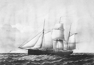
USS Niphon was a steam operated vessel acquired by the Union Navy during the American Civil War. She was used by the Navy to patrol navigable waterways of the Confederacy to prevent the South from trading with other countries.
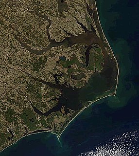
The Outer Banks are a 200 mi (320 km) string of barrier islands and spits off the coast of North Carolina and southeastern Virginia, on the east coast of the United States. They line most of the North Carolina coastline, separating Currituck Sound, Albemarle Sound, and Pamlico Sound from the Atlantic Ocean. A major tourist destination, the Outer Banks are known for their wide expanse of open beachfront and the Cape Hatteras National Seashore. The seashore and surrounding ecosystem are important biodiversity zones, including beach grasses and shrubland that help maintain the form of the land.
North Carolina Highway 12 (NC 12) is a 148.0-mile-long (238.2 km) primary state highway in the U.S. state of North Carolina, linking the peninsulas and islands of the northern Outer Banks. Most sections of NC 12 are two lanes wide, and there are also two North Carolina Ferry System routes which maintain continuity of the route as it traverses the Outer Banks region. NC 12 is part of the Outer Banks Scenic Byway, a National Scenic Byway. The first NC 12 appeared on the 1924 North Carolina Official Map and at its height ran from NC 30 in Pollocksville to NC 48 near Murfreesboro. Over time it was replaced by both U.S. Route 258 (US 258) and NC 58 and ceased to exist in 1958. The current NC 12 first appeared on the 1964 state highway map running from US 158 in Nags Head to Ocracoke. In 1976 NC 12 was extended to US 70 on the mainland and in 1987 was extended north to Corolla.
Oregon Inlet is an inlet along North Carolina's Outer Banks. It joins the Pamlico Sound with the Atlantic Ocean and separates Bodie Island from Pea Island, which are connected by the 2.8 mile Marc Basnight Bridge that spans the inlet. As one of the few access points to the ocean along this stretch of coast, Oregon Inlet is a major departure point for charter fishing trips, with a nearby harbor serving as the base for many large boats that travel miles out towards the Gulf Stream almost every day. The inlet is also the location of a U.S. Coast Guard motor lifeboat station.

Bogue Banks form a 21-mile (34 km) barrier island off the mainland of North Carolina in Carteret County. The island, separated from the mainland by Bogue Sound, runs east to west, with the ocean beaches facing due south. Bogue Banks is the only island on the Carteret County shore that has been developed with housing: numerous communities are located on the island and can be accessed by one of two bridges across Bogue Sound, either from Morehead City to Atlantic Beach, which is the more heavily traveled bridge, or from Cape Carteret to Emerald Isle. The communities of Bogue Banks are the most prominent of the Crystal Coast. NC 58 traverses a majority of the island's length. There are several hotels that dot the island, but most of the land contains private houses, some of which are rented out during the summer, or maritime forest. Stores and other commercial properties are limited to the five main communities.
Bird Island is approximately 1,300 acres (5.3 km2) adjacent to the town of Sunset Beach, North Carolina, USA. Sunset Beach is on a barrier island and is the southernmost town in North Carolina. Bird Island can be reached by walking along the seashore toward the South Carolina border. Due to the contour of the Atlantic Coast at this point, the direction of travel to Bird Island is approximately West-Southwest. Previously, Bird Island was separated from Sunset Beach by a tidal creek that could be easily crossed only at low tide. Accretion of ocean sand has gradually filled in the tidal creek so that two separate islands became one.
Pleasure Island is a coastal barrier island in Southeastern North Carolina, United States, just south of the City of Wilmington. Pleasure Island is located within Federal Point Township, in New Hanover County. The coastal resort towns of Carolina Beach and Kure Beach, as well as the annexed communities of Wilmington Beach and Hanby Beach are located on the island. The southern end of Pleasure Island was separated from Bald Head Island by Corncake Inlet until the inlet was shoaled and closed in 1998 by Hurricane Bonnie; thus Pleasure Island and Bald Head Island are no longer separate islands.
Bodie Island is a long, narrow barrier peninsula that forms the northernmost portion of the Outer Banks. The land that is most commonly referred to as Bodie Island was at one time a true island, but in 1811 Roanoke Inlet, which had separated it from the Currituck Banks in the north, closed. As a result, the Currituck Banks and Bodie Island are now one contiguous peninsula, joined together at the Nags Head area, where the inlet once flowed. Today, either name can be used to refer to peninsula as a whole, but both portions colloquially retain their historical names.

Masonboro Inlet is an inlet in New Hanover County, North Carolina, separating the town of Wrightsville Beach from Masonboro Island. The inlet was used as a hideout by Confederate blockade runners during the Civil War. The blockade runners would hide in the inlet until nightfall, then sail to the nearby port of Wilmington in the cover of darkness.

The Core Banks are barrier islands in North Carolina, part of the Outer Banks and Cape Lookout National Seashore. Named after the Coree tribe, they extend from Ocracoke Inlet to Cape Lookout, and consist of two low-relief narrow islands, North Core Banks and South Core Banks, and, since September 2011, two smaller islands. New Drum Inlet, Old Drum Inlet and Ophelia Inlet now separate the islands. The Core Banks are now uninhabited. However, Portsmouth, at the north end of the North Core Banks, was once a substantial port, and Cape Lookout Village, about one and half miles south of the Cape Lookout Lighthouse, contains the historic Lookout Life-Saving Station, a U.S. Coast Guard Station, and several island homes.