Hardwick, Vermont

Last updated

Hardwick, Vermont
N main st.JPG
North Main Street
Hardwick vt highlight.png
Hardwick, Vermont
Usa edcp location map.svg
Red pog.svg
Hardwick, Vermont
Location in the United States
Coordinates: 44°31′5″N72°20′59″W / 44.51806°N 72.34972°W / 44.51806; -72.34972
Country United States
State Vermont
County Caledonia
Chartered1781
Communities Hardwick
East Hardwick
Hardwick Center
Hardwick Street
Mackville
Area
  Total39.0 sq mi (101.1 km2)
  Land38.6 sq mi (100.0 km2)
  Water0.4 sq mi (1.0 km2)
Elevation
1,339 ft (408 m)
Population
 (2020)
  Total2,920
  Density76/sq mi (29.2/km2)
Time zone UTC-5 (Eastern (EST))
  Summer (DST) UTC-4 (EDT)
ZIP codes
05843, 05836 (in East Hardwick)
Area code 802
FIPS code 50-31825 [1]
GNIS feature ID1462115 [2]
Website hardwickvt.org

Hardwick is a town in Caledonia County, Vermont, United States. The population was 2,920 at the 2020 census. [3] It contains the unincorporated villages of Hardwick, East Hardwick, and Mackville. [4] The town is a commercial center for the region's farming population. [5]

Contents

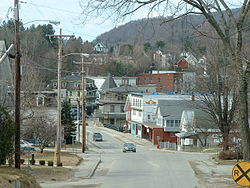
The main settlement of Hardwick in the center of the town, formerly an incorporated village, is since 1988 a census-designated place (CDP), with a population of 1,269 at the 2020 census. [6]

History

During the Revolutionary War, General George Washington ordered construction of the Bayley-Hazen Military Road to provide access into the interior of Vermont. It would prompt the development and settlement of Hardwick and East Hardwick. [7]

The town was granted by the Vermont General Assembly on November 7, 1780, then chartered on August 19, 1781, to Danforth Keyes and 66 others, some of whom were from Hardwick, Massachusetts. Permanent settlement began in 1793 when several families named Norris arrived from New Hampshire. By 1859, when the population reached 1,402, the town had several sawmills and gristmills on the Lamoille River. There were also two tanneries. Over the years, other industries would include a woolen mill, tinware shop, and carriage factory.[ citation needed ]

Fletcher Granite Co. c. 1907 Fletcher Granite Company, Hardwick, VT.jpg
Fletcher Granite Co. c.1907

The predominant business following the Civil War was granite quarrying, especially after the Portland & Ogdensburg Railway opened service through the town and facilitated shipment of stone. While most of the granite was quarried in nearby Woodbury, the stone was dressed and finished in Hardwick, largely near "Granite Junction", where the rail lines met. [8] The Hardwick and Woodbury Railroad was built to bring granite from the quarries to the finishing shops, and Hardwick became known as the "Building Granite Center of the World". [9] By 1906, 1,200 people were employed in the industry, which was led by the Woodbury Granite Company. Buildings around the country made with Hardwick granite include the Pennsylvania State Capitol, Chicago City Hall, and the 1914 Post Office in Washington, D.C., as well as numerous city halls and custom houses. [10] The decline of the "architectural granite" industry in the 1920s and 1930s left Hardwick in economic depression.

Hardwick Village disincorporated in 1988 and merged with the town. [11]

In 2011, the office manager of the municipal electric department was accused of embezzling $1.6 million over a period of 12 years. The FBI investigated, and she was charged in federal court and found guilty. [12] [13]

Geography

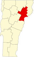
Hardwick is the westernmost town in Caledonia County. It is bordered by the Caledonia County towns of Walden and Stannard to the east. The town of Greensboro, in Orleans County, is to the north. Lamoille County is to the west, containing the town of Wolcott to the west and Elmore to the southwest. To the south, in Washington County, are the towns of Woodbury and Cabot. According to the United States Census Bureau, Hardwick has a total area of 39.0 square miles (101.1 km2), of which 38.6 square miles (100.0 km2) is land and 0.39 square miles (1.0 km2), or 1.02%, is water. [14] The CDP (town center) of Hardwick has a total area of 1.46 square miles (3.77 km2), of which 1.44 square miles (3.73 km2) is land and 0.015 square miles (0.04 km2), or 1.16%, is water. [15]

Hardwick is drained by the Lamoille River and its tributaries, flowing west to Lake Champlain. The highest point in Hardwick is the summit of Jeudevine Mountain in the northern corner of the town, at 1,831 feet (558 m) above sea level.

The town is crossed by Vermont Route 14, Vermont Route 15, and Vermont Route 16.

Demographics

Historical population
CensusPop.Note
1790 3
1800 2608,566.7%
1810 735182.7%
1820 86718.0%
1830 1,21640.3%
1840 1,35411.3%
1850 1,4023.5%
1860 1,369−2.4%
1870 1,51911.0%
1880 1,484−2.3%
1890 1,5474.2%
1900 2,46659.4%
1910 3,20129.8%
1920 2,641−17.5%
1930 2,7203.0%
1940 2,605−4.2%
1950 2,6290.9%
1960 2,349−10.7%
1970 2,4665.0%
1980 2,6136.0%
1990 2,96413.4%
2000 3,1747.1%
2010 3,010−5.2%
2020 2,920−3.0%
U.S. Decennial Census [16]

As of the census [1] of 2000, there were 3,174 people, 1,216 households, and 854 families residing in the town. The population density was 82.4 people per square mile (31.8/km2). There were 1,407 housing units at an average density of 36.5 per square mile (14.1/km2). The racial makeup of the town was 97.89% White, 0.06% African American, 0.82% Native American, 0.09% Asian, 0.19% from other races, and 0.95% from two or more races. Hispanic or Latino of any race were 0.41% of the population.[ citation needed ]

There were 1,216 households, out of which 37.8% had children under the age of 18 living with them, 52.1% were married couples living together, 13.7% had a female householder with no husband present, and 29.7% were non-families. 22.5% of all households were made up of individuals, and 9.0% had someone living alone who was 65 years of age or older. The average household size was 2.61 and the average family size was 3.06.[ citation needed ]

In the town, the population was spread out, with 29.5% under the age of 18, 7.0% from 18 to 24, 28.9% from 25 to 44, 22.7% from 45 to 64, and 11.9% who were 65 years of age or older. The median age was 36 years. For every 100 females, there were 92.9 males. For every 100 females age 18 and over, there were 89.3 males.[ citation needed ]

Economy

Personal income

The median income for a household in the town was $33,636, and the median income for a family was $39,278. Males had a median income of $27,188 versus $21,732 for females. The per capita income for the town was $14,813. About 10.5% of families and 14.0% of the population were below the poverty line, including 16.3% of those under age 18 and 14.2% of those age 65 or over.

Agriculture

Several agribusinesses active in and around Hardwick, [17] employing techniques of sustainable agriculture, [18] have added an estimated 75-100 jobs to the area (through 2008).[ citation needed ] [19] They operate the Vermont Food Venture Center, a "shared-use kitchen incubator for value-added and specialty food producers." [20] The facility should generate the equivalent of 16 full-time jobs when[ when? ] fully operational. [21]

Historic places

View from Buffalo Mountain Hardwick2.jpg
View from Buffalo Mountain

The town contains five places on the National Register of Historic Places:

Government

The federal government granted the town $492,000 in 2008 to upgrade the water system for fire-fighting purposes after a 2005 fire gutted the Bemis block. [22]

The town owns the Hardwick Electric Department. [23]

The town owns 225 feet (69 m) of shoreline on Caspian Lake in Greensboro. The 2.4 acres (0.97 ha) has been used for recreation since 1927. As a result, they pay taxes to Greensboro on land worth $644,000. This was overlooked until 2012. [24] The Vermont State Legislature passed a bill near the end of its 2013 calendar exempting Caspian Lake Public Beach from state taxes, a bill which "appears to solve recent questions between Greensboro and Hardwick regarding taxation of the Public Beach." [25]

Media

Over Lamoille River. Welcome to Hardwick banner Main Street downtown Hardwick VT October 2017.jpg
Over Lamoille River.

The Hardwick Gazette is a weekly newspaper founded in 1889 that serves Hardwick and nine nearby communities. As of 2016 it has a circulation of about 2,200 and was for sale through an essay contest. [26] [27] [28] While the contest did not receive enough entries, a buyer was found from among the entrants and ownership changed in February 2017. [29] The buyer was Ray Smalls. Smalls has a background in business and bought the paper with his wife, putting his retirement plans on hold. Smalls was not able to gain as much success in improving circulation of the paper as he had hoped and has been personally financially supporting the paper for about three years.

Notable people

Related Research Articles

<span class="mw-page-title-main">Washington County, Vermont</span> County in Vermont, United States

Washington County is a county located in the U.S. state of Vermont. Named after George Washington, its shire town is the city of Montpelier and the most populous municipality is the city of Barre. As of the 2020 census, the population was 59,807, making it the third-most populous county in Vermont, but the third-least populous capital county in the United States after Hughes County, South Dakota and Franklin County, Kentucky. Washington County comprises the Barre, Vermont micropolitan statistical area. In 2010, the center of population of Vermont was located in Washington County, in the town of Warren.

<span class="mw-page-title-main">Lamoille County, Vermont</span> County in Vermont, United States

Lamoille County is a county located in the U.S. state of Vermont. As of the 2020 census, the population was 25,945, and it is the third-least populous county in Vermont. Its shire town is the town of Hyde Park, while Morristown is the county's largest town by population as well as its main commercial center. The county was created in 1835 from portions of Orleans, Franklin, Washington, and Chittenden Counties and organized the following year.

<span class="mw-page-title-main">Caledonia County, Vermont</span> County in Vermont, United States

Caledonia County is a county located in the northeastern part of the U.S. state of Vermont. As of the 2020 census, the population was 30,233. Its shire town is the town of St. Johnsbury. The county was created in 1792 and organized in 1796. It was given the Latin name for Scotland, in honor of the many settlers who claimed ancestry there.

<span class="mw-page-title-main">Groton, Vermont</span> Town in Vermont, United States

Groton is a town in Caledonia County, Vermont, United States. The population was 984 at the 2020 census. It contains the places Groton Pond, Rickers Mills, Rickers and West Groton. The unincorporated village of Groton in the southeast corner of town is recorded as the Groton census-designated place (CDP), with a population of 419 at the 2020 census.

<span class="mw-page-title-main">Stannard, Vermont</span> Town in Vermont, United States

Stannard is a town in Caledonia County, Vermont. The population was 208 at the 2020 census. The town has no paved roads.

<span class="mw-page-title-main">Walden, Vermont</span> Town in Vermont, United States

Walden is a town in Caledonia County, Vermont, United States. The population was 956 at the 2020 census. The community has no ZIP code of its own; mail is routed through the West Danville and East Hardwick post offices.

<span class="mw-page-title-main">Elmore, Vermont</span> Town in Vermont, United States

Elmore is a town in Lamoille County, Vermont, United States. It was granted by the Vermont Republic in 1780, and was named for Colonel Samuel Elmore (1720–1805), one of the original grantees. The population was 886 at the 2020 census. Elmore contains the villages of East Elmore and Lake Elmore, as well as Elmore State Park, a 700-acre (2.8 km2) recreational area on the 219-acre (0.9 km2) Lake Elmore and on Elmore Mountain to the west.

<span class="mw-page-title-main">Morristown, Vermont</span> Town in Vermont, United States

Morristown is a town in Lamoille County, Vermont, United States. As of the 2020 census, the population was 5,434. Morristown is the largest town by population in Lamoille County, and its central village of Morrisville serves as the county's main commercial center.

<span class="mw-page-title-main">Wolcott, Vermont</span> Town in Vermont, United States

Wolcott is a town in Lamoille County, Vermont, United States. The town was named for General Oliver Wolcott, a signer of the Declaration of Independence. The population was 1,670 at the 2020 census.

<span class="mw-page-title-main">Craftsbury, Vermont</span> Town in Vermont, United States

Craftsbury is a town in Orleans County, Vermont, United States. The population was 1,343 at the 2020 census. The town includes the unincorporated villages of Craftsbury, Craftsbury Common, Mill Village, and East Craftsbury.

<span class="mw-page-title-main">Woodbury, Vermont</span> Town in Vermont, United States

Woodbury is a town in Washington County, Vermont, United States. The population was 928 at the 2020 census.

<span class="mw-page-title-main">Milton (CDP), Vermont</span> Census-designated place in Vermont, United States

Milton is an unincorporated village within the town of Milton in Chittenden County, Vermont, United States. The village disincorporated in 2003 and became a census-designated place (CDP) in 2008. As of the 2020 census the population was 3,804, out of a population of 10,723 for the entire town.

<span class="mw-page-title-main">Cambridge, Vermont</span> Town in Vermont, United States

Cambridge is a town in Lamoille County, Vermont, United States. The population was 3,839 at the 2020 United States Census. Cambridge includes the villages of Jeffersonville and Cambridge.

<span class="mw-page-title-main">Hyde Park (town), Vermont</span> Town in Vermont, United States

Hyde Park is a town in and the shire town of Lamoille County, Vermont, United States. The town was named for Captain Jedediah Hyde, an early landowner who was a veteran of the American Revolutionary War. The population was 3,020 at the 2020 census. There is also a village of the same name within the town.

<span class="mw-page-title-main">Johnson, Vermont</span> Town in Vermont, United States

Johnson is a town in Lamoille County, Vermont, United States. The population was 3,491 at the 2020 census. The town is home to Northern Vermont University-Johnson, a part the Vermont State Colleges system. The Vermont Studio Center is located in the village of Johnson.

<span class="mw-page-title-main">Albany, Vermont</span> Town in Vermont, United States

Albany is a town in Orleans County, Vermont, United States. The population was 976 at the 2020 census. Albany contains four villages: the incorporated village of Albany, and the unincorporated villages of Albany Center, East Albany and South Albany.

<span class="mw-page-title-main">East Montpelier (CDP), Vermont</span> Census-designated place in Vermont, United States

East Montpelier is a census-designated place (CDP) comprising the central village of the town of East Montpelier, Washington County, Vermont, United States. The population of the CDP was 80 at the 2010 census.

Hardwick is the primary village and a census-designated place (CDP) in the town of Hardwick, Caledonia County, Vermont, United States. As of the 2020 census, the CDP had a population of 1,269, out of 2,920 in the entire town of Hardwick.

Greensboro is the central village and a census-designated place (CDP) in the town of Greensboro, Orleans County, Vermont, United States. As of the 2020 census, it had a population of 156, out of 811 in the entire town of Greensboro.

Wolcott is a census-designated place (CDP) comprising the central community in the town of Wolcott, Lamoille County, Vermont, United States. The CDP was first drawn for the 2020 census.

References

  1. 1 2 "U.S. Census website". United States Census Bureau . Retrieved January 31, 2008.
  2. "US Board on Geographic Names". United States Geological Survey. October 25, 2007. Retrieved January 31, 2008.
  3. "Census - Geography Profile: Hardwick town, Caledonia County, Vermont". United States Census Bureau . Retrieved December 30, 2021.
  4. "Caledonia County, Vermont Local History and Genealogy".
  5. "Archived copy". Archived from the original on October 9, 2007. Retrieved June 16, 2007.{{cite web}}: CS1 maint: archived copy as title (link) retrieved on June 15, 2007
  6. "Census - Geography Profile: Hardwick CDP, Vermont". United States Census Bureau . Retrieved December 30, 2021.
  7. "Bayley Hazen Intro" (PDF).
  8. E.g., Vermont Board of Railroad Commissioners, Seventh Biennial report of the Board of Railroad Commissioners of the State of Vermont, p. 143 (1900).
  9. "Archived copy". Archived from the original on October 9, 2007. Retrieved June 16, 2007.{{cite web}}: CS1 maint: archived copy as title (link)
  10. Elizabeth H. Dow, “Hardwick on the Map, 1895-1915: Industrialization in Direct Democracy”, Vermont History: Proceedings of the Vermont Historical Society, Vol. 58, No. 4, pp. 221-249 (Fall 1990).
  11. "Data" (PDF). vermonthistory.org.
  12. Donoghue, Mike (June 26, 2011). "How $1.6M slid under the radar in Hardwick". Burlington Free Press . Burlington, Vermont. pp. 1A. Archived from the original on July 28, 2012.
  13. "Bellevance Sentenced To 3 1/2 Years For Embezzlement". Vermont Public Radio. Associated Press. January 18, 2012.
  14. "Geographic Identifiers: 2010 Demographic Profile Data (G001): Hardwick town, Caledonia County, Vermont". U.S. Census Bureau, American Factfinder. Archived from the original on February 12, 2020. Retrieved February 4, 2013.
  15. "Geographic Identifiers: 2010 Demographic Profile Data (G001): Hardwick CDP, Vermont". U.S. Census Bureau, American Factfinder. Archived from the original on February 12, 2020. Retrieved February 6, 2013.
  16. "U.S. Decennial Census". United States Census Bureau. Retrieved May 16, 2015.
  17. Gresser, Joseph (March 24, 2010). "Harwick has become the flavor of the month". the Chronicle, Barton, Vermont. p. 10.
  18. "BEN HEWITT: THE TOWN THAT FOOD SAVED - Hardwick's economic future was dim, until a chain of events turned it into one of the most important food towns in America". Gourmet Magazine. October 20, 2008. Archived from the original on September 27, 2013. Retrieved May 29, 2013.
  19. "Our Mission, Our Vision". About the Center for an Agricultural Economy. The Center for an Agricultural Economy. Retrieved June 17, 2013.
  20. "Vermont Food Venture Center". The Center for an Agricultural Economy. Retrieved June 17, 2013.
  21. "Interim Project Manager Hired for Food Processing Incubator in Hardwick". vermontbiz.com. Vermont Business Magazine. December 13, 2010. Retrieved June 17, 2013.
  22. "Leahy-Authored Farm Bill Provision Nets Northeast Kingdom $22 M. in Economic Development Investments". U.S. Senator Patrick Leahy. leahy.senate.gov. October 15, 2008. Archived from the original on January 6, 2010.
  23. "Home - Hardwick Electric Department". www.hardwickelectric.com. Retrieved March 26, 2018.
  24. Gresser, Joseph (September 19, 2012). "How much is 225 feet of Caspian Lake shoreline worth?". the Chronicle. Barton, Vermont. pp. 2, 3.
  25. "Vermont Legislature Exempts Caspian Lake Public Beach from State Tax". The Greensboro Association. May 26, 2013. Retrieved May 28, 2013.
  26. Annear, Steve (June 8, 2016). "Sharpen that pencil! Essay winner will become owner of Vermont newspaper". The Boston Globe .
  27. Wemple, Erik (June 8, 2016). "Owner of small Vermont newspaper launches essay contest for new owner". The Washington Post (Blog).
  28. Hare, Kristen (June 8, 2016). "This Vermont newspaper is having an essay contest. The prize? This Vermont newspaper". Poynter.
  29. "This Vermont newspaper couldn't give itself away in an essay contest. But it did find a buyer". Poynter. February 16, 2017. Retrieved March 26, 2018.
  30. "Biography, Guy W. Bailey (1920-1940)". Former presidents. Burlington, VT: University of Vermont. Archived from the original on September 14, 2017. Retrieved January 23, 2017.
  31. Bigelow, Walter J. (1919). Vermont, Its Government. Montpelier, VT: Historical Publishing Company. p. 14.

Further reading