West Burke, Vermont

Last updated

West Burke, Vermont
USA Vermont location map.svg
Red pog.svg
West Burke
Location within the state of Vermont
Coordinates: 44°38′33″N71°58′49″W / 44.64250°N 71.98028°W / 44.64250; -71.98028
Country United States
State Vermont
County Caledonia
Town Burke
Area
[1]
  Total0.47 sq mi (1.23 km2)
  Land0.47 sq mi (1.23 km2)
  Water0.00 sq mi (0.00 km2)
Elevation
906 ft (276 m)
Population
 (2020)
  Total281
  Density600/sq mi (230/km2)
Time zone UTC-5 (Eastern (EST))
  Summer (DST) UTC-4 (EDT)
ZIP code
05871
Area code 802
FIPS code 50-79150 [2]
GNIS feature ID1460472 [3]
Website www.burkevermont.org

West Burke is a village in the town of Burke, Caledonia County, Vermont, United States. The population was 281 at the 2020 census. [4]

Contents

Geography

West Burke is located 8 miles (13 km) north of the village of Lyndonville along U.S. Route 5. Vermont Route 5A intersects US 5 in the center of the village, leading north to Lake Willoughby. The Sutton River flows into the West Branch of the Passumpsic River in the center of the village.

According to the United States Census Bureau, the village has a total area of 0.46 square miles (1.2 km2), all land. [5]

Demographics

Historical population
CensusPop.Note
1910 325
1930 359
1940 316−12.0%
1950 41431.0%
1960 369−10.9%
1970 358−3.0%
1980 338−5.6%
1990 3534.4%
2000 3643.1%
2010 343−5.8%
2020 281−18.1%
U.S. Decennial Census [6]

As of the census [2] of 2020, there were 281 people and 98 households residing in the village. The population density was 597.9 people per square mile (228.5/km2). There were 150 housing units at an average density of 319.1/sq mi (122.0/km2). The racial makeup of the village was 91.81% White, 1.07% Native American, 0.35% Black/African American, 2.14% Asian, 4.63% Two or More Races. Hispanic or Latino of any race were 1.78% of the population. [7]

There were 98 households, out of which 22.4% were married couples living together, 31.6% had a female householder with no spouse present, and 27.6% had a male householder with no spouse present. In the village, the population was spread out, with 15.3% under the age of 18, 6.76% from 20 to 24, 17.44% from 25 to 44, 41.99% from 45 to 64, and 13.88% who were 65 years of age or older. The median age was 44.9 years. For every 100 females, there were 105.3 males. [7]

The median income for a household in the village was $23,750, and the median income for a family was $44,250. About 34.0% of the population were below the poverty line, including 48.3% of those under age 18 and 35.9% of those age 65 or over. [7]

Related Research Articles

<span class="mw-page-title-main">Gilliam, Louisiana</span> Village in Louisiana, United States

Gilliam is a village in Caddo Parish, Louisiana, United States. The population was 164 at the 2010 census. It is part of the Shreveport–Bossier City Metropolitan Statistical Area.

<span class="mw-page-title-main">Woodlawn, Ohio</span> Village in Ohio, United States

Woodlawn is a village in Hamilton County, Ohio, United States. The population was 3,916 at the 2020 census.

<span class="mw-page-title-main">Bridport, Vermont</span> Town in Vermont, United States

Bridport is a town in Addison County, Vermont, United States. The town was founded October 9, 1761. The population was 1,225 at the 2020 census. The town is named after Bridport, a town in the west of the county of Dorset, in the United Kingdom.

<span class="mw-page-title-main">Winhall, Vermont</span> Town in Vermont, United States

Winhall is a town in Bennington County, Vermont, United States. The population was 1,182 at the 2020 census. In the southeastern corner of the town is the unincorporated village of Bondville. Half of the community of Stratton Mountain, part of Stratton Mountain Resort, is in the southern part of the town.

<span class="mw-page-title-main">Burke, Vermont</span> Town in Vermont, United States

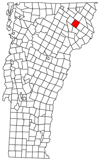
Burke is a town in Caledonia County, Vermont, United States. The population was 1,651 at the 2020 census. The town contains the villages of East Burke, West Burke and Burke Hollow. The town is home to Burke Mountain and Burke Mountain Academy.

<span class="mw-page-title-main">Kirby, Vermont</span> Town in Vermont, United States

Kirby is a town in Caledonia County, Vermont, United States. The population was 575 at the 2020 census.

<span class="mw-page-title-main">Newark, Vermont</span> Town in Vermont, United States

Newark is a town in Caledonia County, Vermont, United States. The population was 584 at the 2020 census.

<span class="mw-page-title-main">Waterford, Vermont</span> Town in Vermont, United States

Waterford is a town in Caledonia County, Vermont, United States. The population was 1,268 at the 2020 census.

<span class="mw-page-title-main">Enosburg Falls, Vermont</span> Village in Vermont, United States

Enosburg Falls is a village in the town of Enosburgh in Franklin County, Vermont, in the United States. The population was 1,356 at the 2020 census.

<span class="mw-page-title-main">Topsham, Vermont</span> Town in Vermont, United States

Topsham is a town in Orange County, Vermont, United States. The population was 1,199 at the 2020 census. It contains four villages: East Topsham, Topsham Four Corners, Waits River, and West Topsham.

<span class="mw-page-title-main">North Troy, Vermont</span> Village in Vermont, United States

North Troy is a village in the town of Troy, Orleans County, Vermont, United States. The population was 631 at the 2020 census. It is located 1.3 miles (2.1 km) south of the Canada-US border.

<span class="mw-page-title-main">Jacksonville, Vermont</span> Village in Vermont, United States

Jacksonville is a village in the town of Whitingham, Windham County, Vermont, United States. The population was 213 at the 2020 census.

<span class="mw-page-title-main">Bridgewater, Vermont</span> Town in Vermont, United States

Bridgewater is a town in Windsor County, Vermont, United States. The population was 903 at the 2020 census. Bridgewater contains the hamlets of Bridgewater Village, Bridgewater Corners, West Bridgewater, and Bridgewater Center.

<span class="mw-page-title-main">Stockbridge, Vermont</span> Town in Vermont, United States

Stockbridge is a town in Windsor County, Vermont, United States, which contains the village of Gaysville. The population was 718 at the 2020 census. Stockbridge was one of thirteen Vermont towns isolated by flooding caused by Hurricane Irene in 2011.

<span class="mw-page-title-main">Weston, Vermont</span> Town in Vermont, United States

Weston is a town in Windsor County, Vermont, United States. The population was 623 at the 2020 census. Home to the Weston Playhouse Theatre Company, it includes the villages of Weston and The Island.

Burke is a village in Franklin County, New York, United States. The population was 211 at the 2010 census. The village is in the town of Burke and is northeast of Malone, the county seat.

Cambridge is a village in the town of Cambridge, Lamoille County, Vermont, United States. The population was 210 at the 2020 census.

<span class="mw-page-title-main">Newfane (village), Vermont</span> Village in Vermont, United States

Newfane is an incorporated village in the town of Newfane in Windham County, Vermont, United States. The population was 87 at the 2020 census.

<span class="mw-page-title-main">Brecon, Ohio</span> Census-designated place in Ohio, United States

Brecon is a census-designated place (CDP) in Sycamore Township, Hamilton County, Ohio, United States. The population was 408 at the 2020 census.

<span class="mw-page-title-main">Shawnee, Hamilton County, Ohio</span> Census-designated place in Ohio, United States

Shawnee is a census-designated place (CDP) in Miami Township, Hamilton County, Ohio, United States, 21 miles (34 km) west of downtown Cincinnati. The population of Shawnee was 747 at the 2020 census.

References

  1. "2019 U.S. Gazetteer Files". United States Census Bureau. Retrieved August 7, 2020.
  2. 1 2 "U.S. Census website". United States Census Bureau . Retrieved January 31, 2008.
  3. "US Board on Geographic Names". United States Geological Survey. October 25, 2007. Retrieved January 31, 2008.
  4. "Census - Geography Profile: West Burke village, Vermont". United States Census Bureau . Retrieved December 26, 2021.
  5. "Geographic Identifiers: 2010 Demographic Profile Data (G001): West Burke village, Vermont". U.S. Census Bureau, American Factfinder. Archived from the original on February 12, 2020. Retrieved February 6, 2013.
  6. "Census of Population and Housing". Census.gov. Retrieved April 26, 2023.
  7. 1 2 3 "West Burke village, Vermont Census Bureau profile". Census Bureau Data. U.S. Census Bureau. Retrieved April 26, 2023.

44°38′29″N71°58′43″W / 44.64139°N 71.97861°W / 44.64139; -71.97861