Harriman is a village in Orange County, New York, United States. It is in the southeastern section of the town of Monroe, with a small portion in the town of Woodbury. The population was 2,714 at the 2020 census. It is part of the Kiryas Joel–Poughkeepsie–Newburgh, NY Metropolitan Statistical Area as well as the larger New York–Newark–Bridgeport, NY-NJ-CT-PA Combined Statistical Area.

In railroad structures, and rail terminology, a wye or triangular junction is a triangular joining arrangement of three rail lines with a railroad switch at each corner connecting to the incoming lines. A turning wye is a specific case.
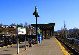
Beacon station is a commuter rail station on the Metro-North Railroad Hudson Line located in Beacon, New York. The station has three tracks, with one island platform and one side platform.

Greystone station is a commuter rail station on the Metro-North Railroad Hudson Line, located in the Greystone neighborhood of Yonkers, New York. The station has two high-level side platforms, each eight cars long, serving the outer tracks of the four-track line.
New York State Route 32 (NY 32) is a north–south state highway that extends for 176.73 miles (284.42 km) through the Hudson Valley and Capital District regions of the U.S. state of New York. It is a two-lane surface road for nearly its entire length, with few divided sections. From Harriman to Albany, it is closely parallel to Interstate 87 (I-87) and U.S. Route 9W (US 9W), overlapping with the latter in several places.
Secaucus Junction is an intermodal transit hub served by New Jersey Transit and Metro-North Railroad in Secaucus, New Jersey. It is one of the busiest railway stations in North America.

The Northeast Corridor Line is a commuter rail service operated by NJ Transit between the Trenton Transit Center and New York Penn Station on Amtrak's Northeast Corridor in the United States. The service is the successor to Pennsylvania Railroad commuter trains between Trenton and New York, and is NJ Transit's busiest commuter rail service. After arrival at New York Penn Station, some trains load passengers and return to New Jersey, while others continue east to Sunnyside Yard for storage. Most servicing is done at the Morrisville Yard, at the west end of the line.

The Main Line is a commuter rail line owned and operated by New Jersey Transit running from Suffern, New York to Hoboken, New Jersey, in the United States. It runs daily commuter service and was once the north–south main line of the Erie Railroad. It is colored yellow on NJ Transit system maps, and its symbol is a water wheel.

The Lehigh and Hudson River Railway (L&HR) was the smallest of the six railroads that were merged into Conrail in 1976. It was a bridge line running northeast–southwest across northwestern New Jersey, connecting the line to the Poughkeepsie Bridge at Maybrook, New York with Easton, Pennsylvania, where it interchanged with various other companies.
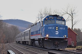
The Port Jervis Line is a predominantly single-track commuter rail line running between Suffern and Port Jervis, in the U.S. state of New York. At Suffern, the line continues south into New Jersey on NJ Transit's Main Line. The line is operated by NJ Transit Rail Operations under a contract with Metro-North Railroad (MNRR).

Monmouth Park is a seasonal NJ Transit commuter rail station on the North Jersey Coast Line, located in Oceanport, New Jersey, and serving the current Monmouth Park Racetrack. The first two locations of Monmouth Park were inside now-closed Fort Monmouth. Both those locations had dedicated rail sidings owned by The Monmouth Park Railroad.

Salisbury Mills–Cornwall station is a commuter rail stop owned by Metro-North Railroad serving trains on the Port Jervis Line, located in the Beaver Dam Lake section of the town of Cornwall, New York. The station is located at the northern end of the Moodna Viaduct, accessible from NY 94.

Campbell Hall station is a commuter rail stop owned by Metro-North Railroad serving trains on the Port Jervis Line, located just south of the hamlet of Campbell Hall, New York in the town of Hamptonburgh. The station is located at the end of Watkins Road, off Egbertson Road. The station contains decorative lights, a long platform roof and an elevated mini-high platform at the east end of the station for access by riders in wheelchairs. Parking is on a permit/meter system.

Otisville station is a commuter rail stop owned by Metro-North Railroad serving trains on the Port Jervis Line, serving the village of Otisville, New York along with the town of Mount Hope. It is located a short distance off New York State Route 211 near the eastern village line.

Port Jervis station is a commuter rail stop owned by Metro-North Railroad serving trains on the Port Jervis Line, located in Port Jervis, New York. It is the western terminus of the Port Jervis Line.

The Orange Heritage Trailway is a 19.5-mile (31.4 km) rail trail in Orange County, New York, that runs along the roadbed of the Erie Railroad's Main Line from Monroe, NY to nearby Middletown.
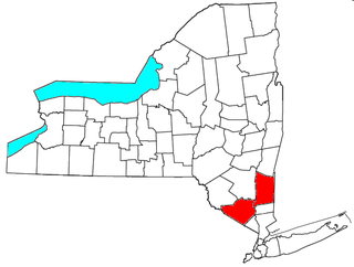
The Kiryas Joel-Poughkeepsie-Newburgh, NY Metropolitan Statistical Area, as defined by the United States Office of Management and Budget, is an area consisting of two counties in New York's Hudson Valley, with the municipalities of Kiryas Joel, Poughkeepsie, and Newburgh as its principal cities. As of the 2020 census, the MSA had a population of 679,221. The area was centered on the urban area of Poughkeepsie-Newburgh. Prior to July 2023, it was known as the Poughkeepsie-Newburgh-Middletown, NY Metropolitan Statistical Area; whereupon it was renamed to its current name, to reflect population changes among its largest municipalities.

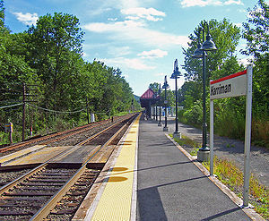
Harriman Station, formerly known as Turner Station until 1910, was the first station on the Erie Railroad Main Line west of Newburgh Junction in Harriman, New York. Built adjacent to Grove Street in Harriman, one of the earlier structures built here in 1838 was a three-story hotel-train station combination. This station caught fire in 1873 and was replaced by a one-story wooden structure. That structure remained in use for decades before it began decaying and was replaced in 1911 with a new station on land donated by the widow of Edward Henry Harriman. A new one-story structure was built on the land. The station was maintained as a one-story depot with an adjacent monument dedicated to the work of Charles Minot. Minot was a director of the Erie Railroad who, in 1851, while his train was stopped at Turner, made the first railroad call by telegraph.

The Graham Line is the portion of the former Erie Railroad in New York State from Highland Mills to Guymard, constructed from 1906 to 1909 as a high-speed freight line. The Graham Line bypasses the original Erie Main Line through Monroe, Chester, Goshen and Middletown. Grade on the Graham Line was not to exceed 0.2% eastward or 0.6% westward, while the original Main Line built in the 1840s had grades up to 1.25%. There were three places where freight trains needed a helper on the old line and none on the new, but just west of the cutoff the grade up from Port Jervis to Guymard could not be improved, and remained unchanged as the only place in the area needing a helper. The sharpest curve on the old line was 7 degrees and on the new was 1 deg 30 min. The Graham Line has no grade crossings: a rarity on the Erie. The downside of the improved grade and curvature is that the Graham Line is seven miles longer than the original mainline. Maintaining the desired grade required two notable engineering features: the Moodna Viaduct and the Otisville Tunnel.
The Erie Railroad Newburgh Branch is a mostly abandoned branch line that travels across the center of Orange County, New York. It survives as the CSX Vails Gate Spur between Newburgh and Vails Gate, but is abandoned between Vails Gate and the end of the line in Greycourt. When it opened in 1850, it was Newburgh's first railroad and remained the only line serving the city for over three decades until the first train operated from Newburgh along the West Shore Railroad in 1883.