Marble Hill station

Last updated

Marble Hill
EMD loco of CSX EB thru Marble Hill Sta jeh.jpg
Freight locomotives pass through the station. October 2014.
General information
Location125 West 225th Street, Marble Hill, Manhattan, New York
Coordinates 40°52′29″N73°54′43″W / 40.8747°N 73.9120°W / 40.8747; -73.9120
Owned by Metro-North Railroad
Line(s) Hudson Line
Platforms1 island platform
Tracks3
Connections BSicon SUBWAY.svg New York City Subway :
NYCS-bull-trans-1-Std.svg at Marble Hill–225th Street
Aiga bus trans.svg New York City Bus : Bx7, Bx9, Bx20
Aiga bus trans.svg MTA Bus : BxM1
Other information
Fare zone2
History
Opened1906
Rebuilt2005
Electrified700V (DC) third rail
Key dates
April 22, 1951Station depot burned [1]
Passengers
20181,382 [2] (Metro-North)
Rank45 of 109 [2]
Services
Preceding station MTA NYC logo.svg Metro-North Railroad Following station
Spuyten Duyvil Hudson Line University Heights
Former services
Preceding station New York Central Railroad Following station
Spuyten Duyvil
toward Peekskill
Hudson Division University Heights
toward New York
BSicon numN060.svg
BSicon MFADEg.svg
BSicon vSTR.svg
BSicon vSTRfg.svg
BSicon GRZq.svg
BSicon vSTR.svg
BSicon dSHI2+l.svg
BSicon dSHI2gr+l.svg
BSicon xdSHI2glr.svg
BSicon dSHI2+r.svg
BSicon vSTRf.svg
BSicon exdSTR.svg
BSicon dSTRg.svg
BSicon dSTR.svg
BSicon dPSTR(L).svg
BSicon dPLT.svg
BSicon dPSTR(R).svg
BSicon dSTR.svg
BSicon dPSTR(L).svg
BSicon dPLT.svg
BSicon dPSTR(R).svg
BSicon vSTRf.svg
BSicon exdSTR.svg
BSicon dSTRg.svg
BSicon GRZq.svg
BSicon vSTR.svg
BSicon GRZq.svg
BSicon evSTR.svg
BSicon MFADEf.svg
BSicon vSTR.svg
BSicon MFADEf.svg
BSicon evSTR.svg
Location
Marble Hill station

Marble Hill station is a commuter rail stop on the Metro-North Railroad's Hudson Line, serving the Marble Hill neighborhood of Manhattan in New York City. The station is located at 125 West 225th Street, [3] two blocks west of the Broadway Bridge on the north side of the Harlem River, near the New York City Subway's Marble Hill–225th Street station (which serves the 1 train).

Contents

The Marble Hill station is frequently used by commuters going to and from the Manhattan neighborhoods of the Upper West Side, Washington Heights, Hudson Heights and Inwood; about a third of the station's daily ridership disembarks at Marble Hill to transfer to the subway. [4]

Marble Hill used to be one of four express stations on the Hudson Line south of Croton–Harmon; most trains stopped there, except for peak-hour trains to and from Poughkeepsie. [5] However, as of November 9,2014, the only express trains that stop there are a few reverse peak trains in the morning, though most trains originating in or terminating at Croton do stop at the station. [6]

History

Prior to the construction of the Harlem River Ship Canal, the Hudson Line went around Marble Hill, and the nearest station was a station in the Bronx named Kingsbridge, which was also the name of a nearby station on the New York and Putnam Railroad. [7] Between 1905 and 1906 the New York Central and Hudson River Railroad realigned the tracks along the north coast of the canal and built Marble Hill station on the east side of the Broadway Bridge. [8] As with the rest of the stations along the Hudson Line, the station became a Penn Central station upon the merger between NYC and Pennsylvania Railroad in 1968. Penn Central continued commuter travel until it was taken over by Conrail in 1976, which at some point, moved the station to the west side of the bridge before the station and commuter line was taken over by Metro-North Railroad in 1983.

Station layout

The station has one narrow, 4-car-long high-level island platform accessible by enclosed stairway from West 225th Street. [9] :1

Until the late 1970s the station lay east of the Broadway Bridge with two low-level side platforms serving a four-track line, providing a more direct connection to the bridge sidewalk via a short flight of steps. However, the current location west of Broadway is closer to the residential section of Marble Hill and the downtown platform of the subway. The former northbound express track was removed.

Related Research Articles

<span class="mw-page-title-main">Metro-North Railroad</span> Commuter rail service in New York and Connecticut

Metro-North Railroad, trading as MTA Metro-North Railroad, is a suburban commuter rail service operated by the Metropolitan Transportation Authority (MTA), a public authority of the U.S. state of New York. Metro-North serves the New York Metropolitan Area, running service between New York City and its northern suburbs in New York and Connecticut, including Port Jervis, Spring Valley, Poughkeepsie, Yonkers, New Rochelle, Mount Vernon, White Plains, Southeast and Wassaic in New York and Stamford, New Canaan, Danbury, Bridgeport, Waterbury, and New Haven in Connecticut. Service in Connecticut is operated under contract with the Connecticut Department of Transportation. Metro-North also provides local rail service within the New York City boroughs of Manhattan and the Bronx.

<span class="mw-page-title-main">Cold Spring station (Metro-North)</span> Metro-North Railroad station in New York

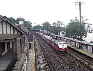
Cold Spring station is a commuter rail stop on the Metro-North Railroad's Hudson Line, located in Cold Spring, New York.

<span class="mw-page-title-main">Philipse Manor station</span> Metro-North Railroad station in New York

Philipse Manor station is a commuter rail stop on the Metro-North Railroad's Hudson Line, located in the Philipse Manor area of Sleepy Hollow, New York, United States.

<span class="mw-page-title-main">Ardsley-on-Hudson station</span> Metro-North Railroad station in New York

Ardsley-on-Hudson station is a commuter rail stop on the Metro-North Railroad's Hudson Line, located in the Ardsley Park area of Irvington, New York. It serves both the neighborhood and the northern part of the village of Dobbs Ferry; the main campus of Mercy College is within walking distance of the station.

<span class="mw-page-title-main">University Heights station</span> Metro-North Railroad station in the Bronx, New York

University Heights station is a commuter rail stop on the Metro-North Railroad's Hudson Line, serving the University Heights neighborhood of the Bronx, New York City.

<span class="mw-page-title-main">Harlem–125th Street station</span> Metro-North Railroad station in Manhattan, New York

Harlem–125th Street station is a commuter rail stop serving the Metro-North Railroad's Hudson, Harlem, and New Haven Lines. It is located at East 125th Street and Park Avenue in East Harlem, Manhattan, New York City. The station also serves as an important transfer point between the Metro-North trains and the New York City Subway's IRT Lexington Avenue Line for access to the Upper East Side of Manhattan. It is the only station besides Grand Central Terminal that serves all three lines east of the Hudson River. Trains leave for Grand Central Terminal, as well as to the Bronx and the northern suburbs, regularly.

<span class="mw-page-title-main">Fordham station</span> Metro-North Railroad station in the Bronx, New York

Fordham station, also known as Fordham–East 190th Street station, is a commuter rail stop on the Metro-North Railroad's Harlem and New Haven Lines, serving Fordham Plaza in the Fordham neighborhood of the Bronx, New York City. The platforms are situated just below street level and feature two expanded side platforms that serve eight cars each, on the outer tracks. The station building sits above the tracks on the Fordham Road overpass, and still bears the name New York Central Railroad on its facade. The station is among the busiest rail stations in the Bronx.

The IRT Broadway–Seventh Avenue Line is a New York City Subway line. It is one of several lines that serves the A Division, stretching from South Ferry in Lower Manhattan north to Van Cortlandt Park–242nd Street in Riverdale, Bronx. The Brooklyn Branch, known as the Wall and William Streets Branch during construction, from the main line at Chambers Street southeast through the Clark Street Tunnel to Borough Hall in Downtown Brooklyn, is also part of the Broadway–Seventh Avenue Line. The IRT Broadway–Seventh Avenue Line is the only line to have elevated stations in Manhattan, with two short stretches of elevated track at 125th Street and between Dyckman and 225th Streets.

<span class="mw-page-title-main">White Plains station</span> Metro-North Railroad station in New York

White Plains station is a commuter rail stop on the Metro-North Railroad's Harlem Line, located in White Plains, New York. With 9,166 daily commuters as of 2006, White Plains is the busiest Metro-North station in Westchester County, the busiest non-terminal or transfer station on the Metro-North system, and the first/last stop outside New York City on most upper Harlem Line express trains.

<span class="mw-page-title-main">Harlem Line</span> Metro-North Railroad line in New York

The Harlem Line is an 82-mile (132 km) commuter rail line owned and operated by the Metro-North Railroad in the U.S. state of New York. It runs north from New York City to Wassaic, in eastern Dutchess County. The lower 53 miles (85 km) from Grand Central Terminal to Southeast, in Putnam County, is electrified with a third rail and has at least two tracks. The section north of Southeast is a non-electrified single-track line served by diesel locomotives. Before the renaming of the line in 1983, it eventually became the Harlem Division of the New York Central Railroad. The diesel trains usually run as a shuttle on the northern end of the line, except for rush-hour express trains in the peak direction.

<span class="mw-page-title-main">Marble Hill–225th Street station</span> New York City Subway station in Manhattan

The Marble Hill–225th Street station is a local station on the IRT Broadway–Seventh Avenue Line of the New York City Subway. Located at the intersection of Broadway and 225th Street in the Marble Hill neighborhood of Manhattan, it is served by the 1 train at all times.

<span class="mw-page-title-main">Hudson Line (Metro-North)</span> Metro-North Railroad line in New York

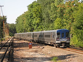
The Hudson Line is a commuter rail line owned and operated by the Metro-North Railroad in the U.S. state of New York. It runs north from New York City along the east shore of the Hudson River, terminating at Poughkeepsie. The line was originally the Hudson River Railroad, and eventually became the Hudson Division of the New York Central Railroad. It runs along what was the far southern leg of the Central's famed "Water Level Route" to Chicago.

<span class="mw-page-title-main">Croton Falls station</span> Metro-North Railroad station in New York

Croton Falls station is a commuter rail stop on the Metro-North Railroad's Harlem Line, located in North Salem, New York.

<span class="mw-page-title-main">Pleasantville station</span> Metro-North Railroad station in New York

Pleasantville station is a commuter rail stop on the Metro-North Railroad's Harlem Line, located in Pleasantville, New York. There is also bus service to the station from Pace University.

<span class="mw-page-title-main">231st Street station</span> New York City Subway station in the Bronx

The 231st Street station is a local station on the IRT Broadway–Seventh Avenue Line of the New York City Subway. Located at the intersection of West 231st Street and Broadway in the Kingsbridge neighborhood of the Bronx, it is served by the 1 train at all times.

<span class="mw-page-title-main">Penn Station Access</span> Public works project in New York City

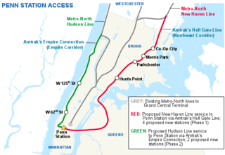
Penn Station Access (PSA) is a public works project underway by the Metropolitan Transportation Authority in New York City. The goal of the project is to allow Metro-North Railroad commuter trains to access Penn Station on Manhattan's West Side, using existing trackage owned by Amtrak. Metro-North trains currently terminate exclusively at Grand Central in Midtown Manhattan.

<span class="mw-page-title-main">Hell Gate Line</span> Railroad line in New York

The Hell Gate Line is the portion of Amtrak's high-speed Northeast Corridor between Harold Interlocking in Sunnyside, Queens, and Shell Interlocking in New Rochelle, New York, within the New York metropolitan area.

<span class="mw-page-title-main">Chambers Street–World Trade Center/Park Place/Cortlandt Street station</span> New York City Subway station in Manhattan

The Chambers Street–World Trade Center/Park Place/Cortlandt Street station is a New York City Subway station complex on the IND Eighth Avenue Line, IRT Broadway–Seventh Avenue Line, and BMT Broadway Line. Located on Church Street between Chambers and Cortlandt Streets in the Financial District of Manhattan, it is served by the 2, A and E trains at all times; W train on weekdays; 3, C and R trains at all times except late nights; and N train during late nights.

References

  1. "Railroad Station Destroyed by Fire". The Philadelphia Inquirer . United Press International. April 23, 1951. p. 9. Retrieved March 14, 2019 via Newspapers.com. Open Access logo PLoS transparent.svg
  2. 1 2 METRO-NORTH 2018 WEEKDAY STATION BOARDINGS. Market Analysis/Fare Policy Group:OPERATIONS PLANNING AND ANALYSIS DEPARTMENT:Metro-North Railroad. April 2019. p. 6.
  3. "MNR Stations". as0.mta.info. Retrieved December 16, 2023.
  4. "MTA Metro-North Railroad to Build Retaining Wall at Marble Hill Station" (Press release). Metro-North Railroad. January 31, 2008. Retrieved February 21, 2010.
  5. "2006 Hudson Line Timetable" (PDF). Archived from the original (PDF) on September 24, 2015.
  6. "Hudson Line Timetable" (PDF).
  7. 1899 Home Life Map of New York City ( Manhattan and the Bronx ) - Geographicus - NYC-HomeLife-1899.jpg (map). 1899. Retrieved October 18, 2014 via WikiMedia Commons.
  8. Documents of the Senate of the State of New York: Volume 3 (1907)
  9. "Metro-North Railroad Track & Structures Department Track Charts Maintenance Program Interlocking Diagrams & Yard Diagrams 2015" (PDF). Metro-North Railroad. 2015. Retrieved January 28, 2019.