Historic South Central Los Angeles

Last updated
Historic South Central Los Angeles
Trade Tech College.jpg
Country Flag of the United States.svg  United States
State Flag of California.svg  California
County Flag of Los Angeles County, California.svg Los Angeles
CityFlag of Los Angeles, California.svg  Los Angeles
Time zone PST
  Summer (DST)PDT

Historic South Central Los Angeles is a 2.25-square-mile neighborhood in Los Angeles, California, within the South Los Angeles region. It is the site of the Bob Hope Patriotic Hall. [1] [2]

Contents

From the late 1800s to early 1910s, African Americans began relocating to the area, mostly organizing around landholdings of Los Angeles pioneer Biddy Mason. [3] The African American population continued to grow into the 1940s, and countless Jazz nightclubs lined South Central Avenue. In the 1990s, the neighborhood shifted to becoming a hub for Latino immigrants, with many being drawn by low rents and central City location. [4] Also with the addition of the Metro Blue Line on the Washington Boulevard corridor has spurred growth, and a community plan recently adopted by the L.A. City Council hopes to revitalize the neighborhood. [5]

Historic South Central neighborhood of the city of Los Angeles, as drawn by the Los Angeles Times Map of the Historic South Central neighborhood of Los Angeles California.jpg
Historic South Central neighborhood of the city of Los Angeles, as drawn by the Los Angeles Times
Bob Hope Patriotic Hall Patriotic hall 5 north side mural.jpg
Bob Hope Patriotic Hall

Geography

Historic South Central flanks Downtown Los Angeles on the northeast, Central-Alameda on the east, South Park on the south, and Vermont Square, Exposition Park and University Park on the west. [6] It is bounded by Washington Boulevard on the north, Central Avenue on the east, East Vernon Avenue on the south and the Harbor Freeway on the west. [7] [8]

Population

A total of 49,728 people lived in the Historic South Central neighborhood's 2.55 square miles, according to the 2000 U.S. census—averaging 19,474 people per square mile, among the highest population densities in both the city and the county. [7] The median age was 23, considered young for the city and the county, and the percentages of residents aged birth through 34 was among the county's highest. [7]

Within the neighborhood, Latinos made up 87.2% of the population, with black people at 10.1%, white people 1.8%; Asian 1.0% and other 0.6%. 56.3% of the neighborhood's residents were born abroad, with Mexico and El Salvador being the most common places of their birth. The percentage of the population born-abroad is considered a high when compared to the city or county as a whole. [7]

The median household income in 2008 dollars was $30,882, considered low for both the city and county. The percentage of households earning $20,000 or less was high, compared to the county at large. The average household size of 4.1 people was above average. Renters occupied 79.6% of the housing units, and homeowners occupied the rest. [7]

The percentages of never-married people were among the county's highest, and there were 2,290 families headed by single parents, or 24.9%, a rate that is considered high for the county and the city. [7]

There were 769 veterans, or 2.5% of the population, considered low compared with the city and the county overall. [7]

Education

Historic South Central is second-highest on the list of Los Angeles city neighborhoods where adults over age 25 did not finish high school—74.2%. [9] Residents of Historic South Central aged 25 and older holding a four-year degree amounted to 3.2% of the population, also considered low when compared with the city and the county as a whole. [7] [9]

Schools within the boundaries of the Historic South Central neighborhood are: [10] [8]

Recreation and parks

Notable buildings

Related Research Articles

<span class="mw-page-title-main">Wilmington, Los Angeles</span> Neighborhood of Los Angeles in Los Angeles, California

Wilmington is a neighborhood in the Harbor region of Los Angeles, California, covering 9.14 square miles (23.7 km2).

<span class="mw-page-title-main">Westchester, Los Angeles</span> Neighborhood of Los Angeles in the United States

Westchester is a neighborhood in the City of Los Angeles and the Westside Region of Los Angeles County, California.

<span class="mw-page-title-main">Mar Vista, Los Angeles</span> Neighborhood of Los Angeles in California, United States of America

Mar Vista is a neighborhood on the Westside of Los Angeles, California. In 1927, Mar Vista became the 70th community to be annexed to Los Angeles. It was designated as an official city neighborhood in 2006.

<span class="mw-page-title-main">Pico-Union, Los Angeles</span> Neighborhood of Los Angeles in California, United States of America

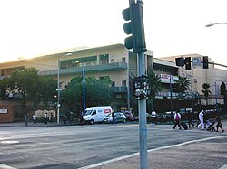
Pico-Union is a neighborhood in Central Los Angeles, California. The name "Pico-Union" refers to the neighborhood that surrounds the intersection of Pico Boulevard and Union Avenue. Located immediately west of Downtown Los Angeles, it is home to over 40,000 residents.

<span class="mw-page-title-main">West Adams, Los Angeles</span> Neighborhood of Los Angeles in California, United States of America

West Adams is a historic neighborhood in the South Los Angeles region of Los Angeles, California. The area is known for its large number of historic buildings, structures and notable houses and mansions.

<span class="mw-page-title-main">Jefferson Park, Los Angeles</span> Neighborhood of Los Angeles in California, United States

Jefferson Park is a neighborhood in the South region of the City of Los Angeles, California. There are five Historic-Cultural Monuments in the neighborhood. In 1987, the Jefferson branch library was added to the National Register of Historic Places.

<span class="mw-page-title-main">South Park, Los Angeles</span> Neighborhood of Los Angeles in California, United States

South Park is a 1.41 square miles (3.65 km2) neighborhood within the South Los Angeles region of Los Angeles, California.

Mid-Wilshire is a neighborhood in the central region of Los Angeles, California. It is known for the Los Angeles County Museum of Art, the Petersen Automotive Museum, and the Miracle Mile shopping district.

<span class="mw-page-title-main">Harbor Gateway, Los Angeles</span> Neighborhood of Los Angeles in California, United States

The Harbor Gateway is a 5.14-square-mile residential and industrial area (13.3 km2) in the Los Angeles Harbor Region, in the southern part of the city. The neighborhood is narrow and long, running along a north-south axis. Its unusual shape has given it the alternative name of "the Shoestring Strip". The northern limit of the neighborhood is Imperial Highway, a city street just north of I-105.

<span class="mw-page-title-main">Mid City, Los Angeles</span> Neighborhood of Los Angeles in California, United States of America

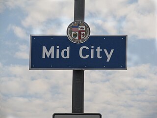
Mid City is a neighborhood in Central Los Angeles, California.

<span class="mw-page-title-main">Arlington Heights, Los Angeles</span> Neighborhood of Los Angeles in California, United States

Arlington Heights is a neighborhood in Central Los Angeles, California.

<span class="mw-page-title-main">Vermont Square, Los Angeles</span> Neighborhood of Los Angeles in California, United States

Vermont Square is a neighborhood in Los Angeles, California, within the South Los Angeles region. The Vermont Square Branch library, a designated Historic–Cultural Monument, is located in the community.

<span class="mw-page-title-main">Lake Balboa, Los Angeles</span> Neighborhood of Los Angeles in California, United States

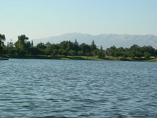
Lake Balboa is a neighborhood in the San Fernando Valley region of Los Angeles, California. The area was previously part of Van Nuys.

<span class="mw-page-title-main">Hyde Park, Los Angeles</span> Neighborhood of Los Angeles in California, United States

Hyde Park is a neighborhood in the South region of Los Angeles, California. Formerly a separate city, it was consolidated with Los Angeles in 1923.

<span class="mw-page-title-main">University Park, Los Angeles</span> Neighborhood of Los Angeles in California, United States

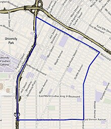
University Park is a 1.17 square miles (3.0 km2) neighborhood in the South Los Angeles region of Los Angeles, California. It is the home of the University of Southern California (USC), Mount St. Mary's College and Hebrew Union College. Additionally, the neighborhood is the home of the historic Shrine Auditorium.

<span class="mw-page-title-main">Manchester Square, Los Angeles</span> Neighborhood of Los Angeles in California, United States

Manchester Square is a neighborhood in Los Angeles, California, within the South Los Angeles region.

<span class="mw-page-title-main">Gramercy Park, Los Angeles</span> Neighborhood of Los Angeles in California, United States

West Park Terrace is a neighborhood in South Los Angeles. The 2009 Mapping L.A. project of the Los Angeles Times gave the same area a different name: Grammercy Park.

Green Meadows is a neighborhood in South Los Angeles, California, with a population of more than thirty thousand people. Green Meadows is within the South Los Angeles Community Plan area and is the home of Locke College Preparatory Academy.

<span class="mw-page-title-main">Exposition Park, Los Angeles</span> Neighborhood of Los Angeles in California, United States

Exposition Park is a neighborhood in the south region of Los Angeles, California. It is home to Exposition Park, which includes the Los Angeles Memorial Coliseum, Banc of California Stadium, Exposition Rose Garden and three museums: the California African American Museum, the California Science Center and the Natural History Museum of Los Angeles County. It is also home to a Science Center Academy.

<span class="mw-page-title-main">Vermont Vista, Los Angeles</span> Neighborhood of Los Angeles in California, United States

Vermont Vista is a neighborhood in Los Angeles, California, within the South Los Angeles area.

References

  1. 1 2 Los Angeles County Arts Commission
  2. 1 2 Archived 2013-05-16 at the Wayback Machine County of Los Angeles
  3. Garner, Scott. "Neighborhood Spotlight: Historic South-Central looks toward growth in several directions". latimes.com. Retrieved 2018-09-19.
  4. TOBAR, HECTOR (1990-05-03). "Latinos Move to South-Central L.A. : Drawn by Low Rents, They Replace Blacks". Los Angeles Times. ISSN   0458-3035 . Retrieved 2018-09-19.
  5. Garner, Scott. "Neighborhood Spotlight: Historic South-Central looks toward growth in several directions". latimes.com. Retrieved 2018-09-19.
  6. "South Los Angeles," Mapping L.A., Los Angeles Times
  7. 1 2 3 4 5 6 7 8 "Historic South Central," Mapping L.A., Los Angeles Times
  8. 1 2 3 4 5 The Thomas Guide, 2006, pages 634 and 674]
  9. 1 2 "Less Than High School," Mapping L.A., Los Angeles Times
  10. [ dead link ] "Historic South-Central Schools," Mapping L.A., Los Angeles Times
  11. Los Angeles City Department of Recreation and Parks
  12. Archived 2005-03-02 at the Wayback Machine Marjorie Mathews, memo, June 5, 2002, Board of Recreation and Park Commissioners
  13. Los Angeles City Department of Recreation and Parks

Coordinates: 34°01′30″N118°16′07″W / 34.0249°N 118.2686°W / 34.0249; -118.2686