
Arleta is a neighborhood in the San Fernando Valley region of the city of Los Angeles, California, with a high percentage of Latino residents and of people born outside the United States.
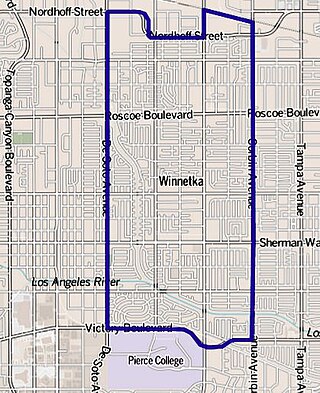
Winnetka is a neighborhood in the west-central San Fernando Valley in the city of Los Angeles. It is a highly ethnically diverse area, both for the city and for Los Angeles County, with a relatively large percentage of Hispanic and Asian people.

Mount Washington is a historic neighborhood in the San Rafael Hills of Northeast Los Angeles, California. Founded in 1909, it includes the Southwest Museum, the world headquarters of the Self-Realization Fellowship, and Eldred Street, one of the three steepest streets in Los Angeles.
The Los Angeles Westside is an urban region in western Los Angeles County, California, United States. It has no official definition, but sources like LA Weekly and the Mapping L.A. survey of the Los Angeles Times place the region on the western side of the Los Angeles Basin south of the Santa Monica Mountains.
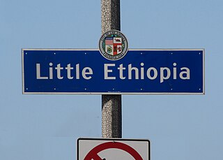
Little Ethiopia is a neighborhood in the central region of Los Angeles. It is known for its collection of Ethiopian restaurants, coffee shops, boutiques and thrift stores.

Jefferson Park is a neighborhood in the South region of the City of Los Angeles, California. There are five Historic-Cultural Monuments in the neighborhood. In 1987, the Jefferson branch library was added to the National Register of Historic Places.

East Hollywood is a densely populated neighborhood of 78,000+ residents that is part of the Hollywood area of the central region of Los Angeles, California. It is notable for being the site of Los Angeles City College, Barnsdall Park, and a hospital district. There are seven public and five private schools, a Los Angeles Public Library branch, and three hospitals. Almost two-thirds of the people living there were born outside the United States, and 90% were renters. In 2000, the neighborhood had high percentages of never-married people and single parents.

Glassell Park is a neighborhood of Northeast Los Angeles, California, in the San Rafael Hills.

South Park is a 1.41 square miles (3.65 km2) neighborhood within the South Los Angeles region of Los Angeles, California.

Olympic Boulevard is a major arterial road in Los Angeles, California. It stretches from Ocean Avenue on the western end of Santa Monica to East Los Angeles—farther than Wilshire Boulevard and most other streets.
Spaulding Square is a neighborhood in Los Angeles, California.
Prospect Park is a residential neighborhood in Pasadena, California. It is bordered by Westgate Street to the north, Orange Grove Boulevard to the south, Rosemont Avenue to the west, and Lincoln Avenue to the east.
The Los Angeles Avenues refer to a series of 50 numbered streets in Los Angeles, California in the Northeast and Eastside regions. They are all designated with the word "Avenue" followed by a number such as "Avenue 64." The Avenues are located in the Los Angeles neighborhoods of Lincoln Heights, Cypress Park, Montecito Heights, Glassell Park, Highland Park, Mt. Washington and Eagle Rock. They are not related to 2nd through 13th Avenues west of Arlington Avenue in Jefferson Park and other neighborhoods in South Los Angeles.

Cahuenga ( or "place of the hill" is a former Tongva–Tataviam Native American settlement in the San Fernando Valley of Los Angeles, Los Angeles County, California. One source suggests kawe means mountain in Tongva language. Recent linguistic work suggests an alternative meaning of "place of the fox".

Historic South Central Los Angeles is a 2.25-square-mile neighborhood in Los Angeles, California, within the South Los Angeles region. It is the site of the Bob Hope Patriotic Hall.

Arroyo Calabasas is a 7.0-mile-long (11.3 km) tributary of the Los Angeles River, in the southwestern San Fernando Valley area of Los Angeles County in California.

Burbank Western Channel is a 6.3-mile-long (10.1 km) tributary of the Los Angeles River in the eastern San Fernando Valley of Los Angeles County, California.
Vermont-Slauson is a 1.44-square-mile neighborhood within the South Los Angeles region of Los Angeles, California.

Exposition Park is a neighborhood in the south region of Los Angeles, California. It is home to Exposition Park, which includes the Los Angeles Memorial Coliseum, BMO Stadium, Exposition Rose Garden and three museums: the California African American Museum, the California Science Center and the Natural History Museum of Los Angeles County. It is also home to a Science Center Academy.

Beverly Grove is an area within the Beverly–Fairfax neighborhood in the Mid-City West region of Los Angeles, California.


