San Antonio, officially the City of San Antonio, is a city in and the county seat of Bexar County, Texas. The city is the seventh-most populous in the United States, the second-largest in the Southern United States, and the second-most populous in Texas. It is the 12th-most populous city in North America, with 1,434,625 residents as of 2020.

El Paso is a city in and the county seat of El Paso County, Texas, United States. The 2020 population of the city from the U.S. Census Bureau was 678,815, making it the 22nd-largest city in the U.S., the sixth-largest city in Texas. The city has also the largest hispanic population share of main cities in the U.S. with 81% of its population being Hispanic. Its metropolitan statistical area covers all of El Paso and Hudspeth counties in Texas, and had a population of 868,859 in 2020. El Paso has consistently been ranked as one of the safest large cities in the United States.

Samuel Augustus Maverick was a Texas lawyer, politician, land baron and signer of the Texas Declaration of Independence. His name is the source of the term "maverick," first cited in 1867, which means "independently minded." Various accounts of the origins of the term held that Maverick came to be considered independently minded by his fellow ranchers because he refused to brand his cattle, though it might have instead reflected a lack of interest in ranching. Unbranded cattle which were not part of the herd came to be labeled "mavericks". He was the grandfather of Texas politician Maury Maverick, who coined the term gobbledygook (1944).

Benito Juárez, is a borough in Mexico City. It is a largely residential area, located to the south of historic center of Mexico City, although there are pressures for areas to convert to commercial use. It was named after Benito Juárez, president in the 19th century.

The following is an alphabetical list of articles related to the U.S. state of Texas.
Samuel Augustus Maverick Jr. (1837–1936) was a Texas soldier and businessman, born May 14, 1837, at Montpelier Plantation, near Pendleton, South Carolina, the first-born of Samuel Augustus Maverick and Mary Ann Adams. His parents brought him to Texas in June 1838 and he grew up in San Antonio during the Republic. In two volumes of memoirs, he recounted his memories of the Council House Fight in 1840, the evacuation of the city during the incursion by Gen. Rafael Vásquez in 1842, and his father's return from the prison at Perote, Veracruz, in 1843.

The San Antonio River Walk is a city park and special-case pedestrian street in San Antonio, Texas, one level down from the automobile street. The River Walk winds and loops under bridges as two parallel sidewalks lined with restaurants and shops, connecting the major tourist draws such as the Shops at Rivercenter, the Arneson River Theatre, Marriage Island, La Villita, HemisFair Park, the Tower Life Building, the San Antonio Museum of Art, the Pearl, and the city's five Spanish colonial missions, which have been named a World Heritage Site, which includes the Alamo. During the annual springtime Fiesta San Antonio, the River Parade features flowery floats that float down the river.

Pompeo Luigi Coppini was an Italian born sculptor who emigrated to the United States. Although his works can be found in Italy, Mexico and a number of U.S. states, the majority of his work can be found in Texas. He is particularly famous for the Alamo Plaza work, Spirit of Sacrifice, a.k.a. The Alamo Cenotaph, as well as numerous statues honoring Texan figures.
Alamo Heights High School is a public high school located in the city of Alamo Heights, Texas and is the only high school in the Alamo Heights Independent School District.

Alameda Central is a public urban park in downtown Mexico City. Created in 1592, the Alameda Central is the oldest public park in the Americas. It is located in Cuauhtémoc borough, adjacent to the Palacio de Bellas Artes, between Juárez Avenue and Hidalgo Avenue. Alameda Central can be accessed by Metro Bellas Artes.
The city of San Antonio in the U.S. state of Texas is composed of a number of neighborhoods and districts, spreading out surrounding the central Downtown Area.

Downtown San Antonio is the central business district of San Antonio, Texas and the urban core of Greater San Antonio, a metropolitan area with nearly 2.5 million people.
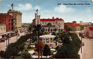
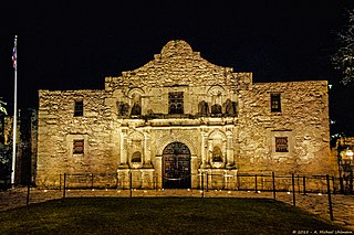
The Alamo Plaza Historic District is an historic district of downtown San Antonio in the U.S. state of Texas. It was listed on the National Register of Historic Places in 1977. It includes the Alamo, which is a separately listed Registered Historic Place and a U.S. National Historic Landmark.

The City of San Antonio is one of the oldest Spanish settlements in Texas and was, for decades, its largest city. Before Spanish colonization, the site was occupied for thousands of years by varying cultures of indigenous peoples. The historic Payaya Indians were likely those who encountered the first Europeans.

El Paso–Juárez, also known as Juárez–El Paso, the Borderplex or Paso del Norte, is a transborder agglomeration, on the border between Mexico and the United States. The region is centered on two large cities: Ciudad Juárez, Chihuahua, Mexico, and El Paso, Texas, U.S. Additionally, nearby Las Cruces, New Mexico, U.S., is sometimes included as part of the region, referred to as El Paso–Juárez–Las Cruces or El Paso–Juárez–Southern New Mexico. With over 2.7 million people, this binational region is the 2nd largest conurbation on the United States–Mexico border. The El Paso–Juárez region is the largest bilingual, binational work force in the Western Hemisphere.
José Antonio de la Garza, was a Tejano who was the first landowner in San Antonio, Texas, and the first man to create a coin in this state. Antonio de la Garza was elected mayor of San Antonio in 1813 and 1832.
The San Antonio and Aransas Pass Railway first began operation in the U.S. state of Texas in 1886. It was developed by Uriah Lott and businessmen of San Antonio as a direct route from the city to Aransas Bay on the Texas Gulf coast. It was eventually absorbed in the 20th century by Southern Pacific.

Travis Park is located in San Antonio in Bexar County in the U.S. state of Texas. Once a part of the original Alamo Mission in San Antonio, the park is located across the street from the restored Saint Anthony Hotel.

Avenida Juárez is a street in the Historic Center of Mexico City flanking the south side of the centuries-old Alameda Central park.
