Wurzbach Parkway

Last updated

Texas PA 1502.svg

Wurzbach Parkway

Principal Arterial State System 1502
Wurzbach Parkway
Wurzbach Parkway highlighted in red
Route information
Maintained by TxDOT
Length9.8 mi [1]  (15.8 km)
Major junctions
West endLockhill–Selma Road in San Antonio
Major intersections
East endO'Connor Road in San Antonio
Location
Country United States
State Texas
Counties Bexar
Highway system

Wurzbach Parkway is a part freeway and part major arterial road in San Antonio, Texas, built to provide relief on Interstate 410 (I-410) and Loop 1604 on the city's north side. The highway is named for Harry M. Wurzbach, who represented the San Antonio area in Congress as a Republican in the 1920s and 1930s. The congressman's name was first applied to the connecting Wurzbach Road. The highway's western third was built as an expressway with at-grade intersections and the remainder as a freeway. The opening in September 2015 of an interchange with U.S. Highway 281 (US 281) [2] completed primary construction of the parkway. The highway, along with part of Wurzbach Road near the Ingram Park Mall, is maintained by the Texas Department of Transportation despite not carrying a state highway designation. Rather, it is being developed and maintained under the Principal Arterial State System (PASS) program, under which it is designated as PASS Project 1502. [1] [3] The parkway includes an interchange with US 281, and drivers can access I-10 and I-35 via local roads that extend the parkway.

Contents

Route description

The west portion of the parkway is a limited-access surface road that connects Lockhill–Selma Road to West Avenue, crossing Blanco Road (FM 2696) with an interchange, and Military Highway (Farm to Market Road 1535, FM 1535) at-grade. Wurzbach Road continues southwest from Lockhill-Selma Road, crossing I-10 at exit 561. The area between West Avenue and Wetmore Road includes an interchange with US 281. From Wetmore Road, on the northeast side of the San Antonio International Airport, the parkway continues east beyond Thousand Oaks Drive. At the east end are several at-grade intersections before the parkway ends at O'Connor Road and Crosswinds Way; O'Connor Road leads southeast to I-35 at exit 169. [4]

History

Planners conceived the parkway in the mid-1980s as the East–West Parkway, an extension of the existing Wurzbach Road, to relieve traffic on I-410. The road, estimated to cost $90 million, [5] was approved by the Texas Transportation Commission in 1988, to be built by the state but funded in part by the City of San Antonio. [6] Construction began in mid-1994 on the section between Wetmore Road and Nacogdoches Road and opened in July 1996. [7] The eastern portion of the roadway opened on August 26, 1999, allowing traffic to bypass I-410. [8] The west section was opened on July 24, 2002; [9] its fourth section opened on December 23, 2013. In September 2015, the central stretch of the parkway opened to traffic, effectively completing the project after 21 years. [10]

The Alamo Regional Mobility Authority (RMA) conducted a supplemental environmental assessment on the entire corridor from Lockhill–Selma Road to I-35, emphasizing the segment that had not been constructed. The EA supplemented the EA completed several years prior to initial construction. [11] The Alamo RMA considered three alternatives for the interchange with US 281. The first alternative was a Wurzbach Parkway bridge over US 281 with no direct connection between the two highways, but with access via the highway's two frontage roads (this option was chosen). [12] The second option would have included an elevated roundabout interchange to provide direct access between the highways. [13] The final alternative would have involved main lane to main lane connector ramps from Wurzbach Parkway to US 281 and loop ramps for access from US 281 to Wurzbach Parkway. [14]

According to the San Antonio Express-News, the Texas Transportation Commission reviewed the parkway expansion on November 19, 2009. The project was funded by proceeds from Proposition 12 bonds approved by voters in 2007, a package which was voted on by commissioners. Clay Smith, TxDOT's San Antonio District planning engineer, said the Wurzbach Parkway project would get $126 million under the bond-financing plan, enough for TxDOT to finish the three final segments left on the parkway. The expansion construction was completed in two phases: the first from Blanco Road to West Avenue and from Jones Maltsberger Road to Wetmore; the second between West Avenue and Jones Maltsberger. [15]

The parkway has no ramps that connect directly to I-35 to the east (only allowing drivers to use O'Connor Road that leads to the parkway) and no plans for Wurzbach Parkway to extend to I-10 to the west (only allowing drivers to use the Wurzbach Road exit to connect to the parkway).

Future

TxDOT has also proposed improvements to the parkway's intersections at NW Military Highway and Lockhill-Selma Road. [16]

Major junctions

The entire route is in San Antonio, Bexar County. All exits are unnumbered.

mi [17] kmDestinationsNotes
0.000.00Lockhill-Selma RoadWestern terminus; road continues southwest as Wurzbach Road
0.50.80Texas FM 1535.svg FM 1535 (Northwest Military Highway)
1.52.4Texas FM 2696.svg FM 2696 (Blanco Road)West end of limited-access segment
2.13.4Vista del Norte DriveNo eastbound access to/from Visita del Norte Drive north, no westbound exit to Vista del Norte Drive south
2.74.3West Avenue
3.25.1US 281.svg US 281
4.57.2Jones-Maltsberger RoadEast end of limited-access segment
5.79.2Starcrest DriveInterchange; access to Skyplace FBO at San Antonio International Airport
6.810.9Wetmore RoadWest end of limited-access segment
7.812.6Nacogdoches RoadEastbound entrance ramp has direct access to/from Perrin Central Boulevard
8.613.8Texas FM 2252.svg FM 2252 (Perrin-Beitel Road)
9.214.8Tool Yard – Heroes Stadium Right-in/right-out interchange
9.515.3Thousand Oaks Drive
10.416.7TurnaroundEast end of limited access segment; eastbound exit and westbound entrance
11.318.2O'Connor Road / Crosswinds WayEastern terminus; road continues south as O'Connor Rd.
1.000 mi = 1.609 km; 1.000 km = 0.621 mi

Related Research Articles

<span class="mw-page-title-main">San Antonio</span> City in Texas, United States

San Antonio, officially the City of San Antonio, is a city in and the county seat of Bexar County, Texas, United States. The city is the seventh-most populous in the United States, the second-largest in the Southern United States, and the second-most populous in Texas after Houston. San Antonio is the largest city of the San Antonio–New Braunfels metropolitan statistical area. Commonly called Greater San Antonio, the metropolitan area had a population of 2,601,788 based on the 2020 U.S. census estimates, making it the 24th-largest metropolitan area in the United States and third-largest in Texas.

<span class="mw-page-title-main">Interstate 37</span> Interstate Highway in South Texas

Interstate 37 (I-37) is a 143-mile (230 km) Interstate Highway located within the southern portion of the US state of Texas. The highway was first designated in 1959 as a route between Corpus Christi and San Antonio. Construction in the urban areas of Corpus Christi and San Antonio began in the 1960s, and the segments of the Interstate Highway in rural areas were completed by the 1980s. Prior to I-37, the route between Corpus Christi and San Antonio was served by a combination of State Highway 9 (SH 9) from Corpus Christi to Three Rivers and US Highway 281 (US 281) from Three Rivers to San Antonio. As a result of the construction of I-37, SH 9 was removed from the State Highway System.

<span class="mw-page-title-main">U.S. Route 281</span> Highway in the United States

U.S. Route 281 (US 281) is a north–south United States Numbered Highway. At 1,875 miles (3,018 km) it is the longest continuous three-digit U.S. Route.

<span class="mw-page-title-main">U.S. Route 290</span> Highway in Texas

U.S. Route 290 is an east–west U.S. Highway located entirely within the state of Texas. Its western terminus is at Interstate 10 southeast of Segovia, and its eastern terminus is at Interstate 610 in northwest Houston. It is the main highway between Houston and Austin and is a cutoff for travelers wanting to bypass San Antonio on Interstate 10. Throughout its length west of Austin, US 290 cuts across mountainous hills comprising the Texas Hill Country and the Edwards Plateau; between Austin and Houston, the highway then travels through gradually hilly grasslands and pine forests comprising the Gulf Coastal Plains.

<span class="mw-page-title-main">Superstreet</span> Type of high capacity intersection

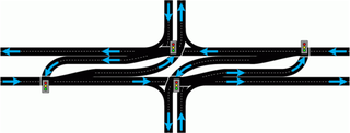
A superstreet, also known as a restricted crossing U-turn (RCUT), J-turn, or reduced conflict intersection (RCI), is a type of road intersection that is a variation of the Michigan left. In this configuration, in contrast to the Michigan left, traffic on the minor road is not permitted to proceed straight across the major road or highway. Drivers on the minor road wishing to turn left or go straight must turn right onto the major road, then, a short distance away, queue (wait) into a designated U-turn lane in the median. When traffic clears, they complete the U-turn and then either go straight or make a right turn when they intersect the other half of the minor road.

<span class="mw-page-title-main">Interstate 410</span> Interstate Highway in Texas, United States

Interstate 410 (I-410), colloquially Loop 410, is an auxiliary route of I-10 around San Antonio, Texas. It is identified as the Connally Loop in honor of former Texas Governor John Connally.

<span class="mw-page-title-main">Texas State Highway 99</span> State highway in Texas, United States

State Highway 99, also known as the Grand Parkway, is a beltway in the U.S. state of Texas. Its first section opened on August 31, 1994. When the route is completed, it will be the longest beltway in the U.S., the world's seventh-longest ring road, and the third (outer) loop of the Houston–The Woodlands–Sugar Land metropolitan area, with Interstate 610 being the first (inner) loop and Beltway 8 being the second (middle) loop. The proposed 170-mile (270 km) loop has been divided into 11 separate segments for construction and funding purposes. In May 2019, the Texas Department of Transportation gave the Grand Parkway a secondary designation as the Mayor Bob Lanier Memorial Parkway, honoring Bob Lanier, who served as the mayor of Houston from 1992 to 1998 and who had spearheaded the creation of the Grand Parkway.

The Harris County Toll Road Authority maintains and operates a 103-mile (165.8 km) toll road system in the Greater Houston area of Texas, United States. Its headquarters are located in Houston's Fairbanks/Northwest Crossing neighborhood.

<span class="mw-page-title-main">Texas State Highway Loop 1604</span> Loop highway around San Antonio, Texas

Loop 1604 is the outer highway loop encircling San Antonio, Texas, spanning approximately 95.6 miles (153.9 km). Originally constructed as a two-lane highway, the northern segment of the route, from US 90 in western San Antonio to Kitty Hawk Road in northeastern Bexar County, has been upgraded to a four-lane freeway. Loop 1604 is designated the Charles W. Anderson Loop in honor of former Bexar County Judge Charles W. Anderson, who died from cancer in 1964 after serving for 25 years.

<span class="mw-page-title-main">Texas State Highway 130</span> Pickle Parkway, highway in Texas

State Highway 130 (SH 130), also known as the Pickle Parkway, is a freeway from Interstate 35 (I-35) in San Antonio along I-410 and I-10 to east of Seguin, then north as a toll road from there to I-35 north of Georgetown. SH 130 runs in a 91-mile (146 km) corridor east and south of Austin. The route parallels I-35 and is intended to relieve the Interstate's traffic volume through the San Antonio–Austin corridor by serving as an alternate route.

<span class="mw-page-title-main">Texas State Highway 151</span>

State Highway 151, also known as the Raymond E. Stotzer Jr. Freeway, is a 10.7-mile (17.2 km) state highway in the U.S. state of Texas that runs from Loop 1604 to U.S. Highway 90 (US 90) in San Antonio. SH 151 is a limited-access freeway for its entire length with the exception of its junction with Loop 1604 at its western terminus where a traffic light controls the junction. The routing of the freeway was first conceived in 1983 and construction was conducted in phases through the 1980s and 1990s until completion in 2004. The freeway provides access to the western part of San Antonio, the SeaWorld San Antonio theme park, Chase, Northwest Vista College, and the future site of a Microsoft data center.

<span class="mw-page-title-main">Interstate 10 in Texas</span> Section of Interstate Highway in Texas, United States

Interstate 10 (I-10) is the major east–west Interstate Highway in the Southern United States. In the U.S. state of Texas, it runs east from Anthony, at the border with New Mexico, through El Paso, San Antonio, and Houston to the border with Louisiana in Orange. At just under 880 mi (1,420 km), the Texas segment of I-10, maintained by the Texas Department of Transportation, is the longest continuous untolled freeway in North America that is operated by a single authority. It is also the longest stretch of Interstate Highway with a single designation within a single state. Mile marker 880 and its corresponding exit number in Orange, Texas, are the highest numbered mile marker and exit on any freeway in North America. After widening was completed in 2008, a portion of the highway west of Houston is now also believed to be the widest in the world, at 26 lanes when including feeders.

<span class="mw-page-title-main">U.S. Route 90 in Texas</span> Section of U.S. Numbered Highway in Texas, United States

U.S. Route 90 is a major east-west highway in the U.S. state of Texas with large portions of it running concurrently with I-10. US 90 begins at Bus. I-10 in Van Horn, travels through San Antonio and Houston, and continues on into the state of Louisiana.

<span class="mw-page-title-main">U.S. Route 281 in Texas</span> Section of U.S. Highway in Texas, United States

U.S. Route 281 (US 281) is a United States Numbered Highway that runs from the Mexican border in the Rio Grande Valley to the Canadian border near Dunseith, North Dakota. In the state of Texas, the highway is a major south–north corridor, connecting Brownsville to the Oklahoma state line at the Red River in Burkburnett. Several segments of U.S. 281 are concurrent with Interstate routes, including I-69C in the Rio Grande Valley, I-37 in San Antonio, and I-44 north of Wichita Falls.

<span class="mw-page-title-main">Interstate 35 in Texas</span> Section of Interstate Highway in Texas, United States

Interstate 35 (I-35) is a major north–south Interstate Highway that runs from Laredo, Texas near the Mexican border to Duluth, Minnesota. In Texas, the highway begins in Laredo and runs north to the Red River north of Gainesville, where it crosses into Oklahoma. Along its route, it passes through the cities of San Antonio, Austin, and Waco before splitting into two branch routes just north of Hillsboro: I-35E heads northeast through Dallas, while I-35W turns northwest to run through Fort Worth. The two branches rejoin in Denton to again form I-35, which continues to the Oklahoma state line. The exit numbers for I-35E maintain the sequence of exit numbers from the southern segment of I-35, and the northern segment of I-35 follows on from the sequence of exit numbers from I-35E. I-35W maintains its own sequence of exit numbers.

<span class="mw-page-title-main">Texas State Highway Spur 345</span>

Spur 345 is a 5.1-mile-long (8.2 km) route in Greater San Antonio in the U.S. state of Texas, maintained by the Texas Department of Transportation (TxDOT). It follows a former route of U.S. Route 87 (US 87) through Balcones Heights and northwest San Antonio. Known locally as Fredericksburg Road, it is a major arterial for the cities of San Antonio and Balcones Heights, providing access to the headquarters of United Services Automobile Association (USAA) and to the South Texas Medical Center.

<span class="mw-page-title-main">Texas State Highway Loop 368</span>

Loop 368 is a state highway loop in the U.S. state of Texas that follows a former route of US 81 in San Antonio. 8.115 miles (13.060 km) in length, the route is a major arterial in the city, providing access to Brackenridge Park, the San Antonio Zoo, and the University of the Incarnate Word.

The North Tarrant Express (NTE) project is a total highway reconstruction of the Interstate 820 (I-820) and State Highway 121/State Highway 183 corridor between I-35W and Industrial Boulevard in Northeast Tarrant County, Texas. The NTE and the Texas Department of Transportation (TxDOT) anticipate the new highway system will relieve traffic congestion, improve safety on its roadways and have integrated plans for the anticipated traffic growth in one of the country’s fastest developing regions. When the improvements are completed, the $2.5 billion North Tarrant Express will have upgraded main highway lanes, continuous frontage roads, and 13.3 miles (21.4 km) of newly added tolled managed lanes.

<span class="mw-page-title-main">Farm to Market Road 2696</span>

Farm to Market Road 2696 is a 16-mile (26 km) farm to market road in Bexar County, Texas. It is known in Greater San Antonio as Blanco Road, a major north–south thoroughfare.

<span class="mw-page-title-main">Texas State Highway Spur 536</span>

State Highway Spur 536 is a state highway spur in San Antonio, Texas.

References

  1. 1 2 Transportation Planning and Programming Division (n.d.). "Principal Arterial State System No. 1502". Highway Designation Files. Texas Department of Transportation . Retrieved September 19, 2007.
  2. Alamo Regional Mobility Authority. "Wurzbach Parkway Corridor".
  3. Transportation Planning and Programming Division (n.d.). "Highway Designations Glossary". Texas Department of Transportation. Archived from the original on June 12, 2007. Retrieved September 19, 2007.
  4. Google (September 19, 2007). "Overview Map of Wurzbach Parkway" (Map). Google Maps . Google. Retrieved September 19, 2007.
  5. Pasley, Dave (December 21, 2005). "S.A. Needs More Roads, not Toll Booths". San Antonio Express-News .
  6. Wood, Jim (April 4, 1993). "Wurzbach Parkway Work Seen in '94 $95 Million Project to Relieve Traffic Congestion". San Antonio Express-News. p. 1B.
  7. Wood, Jim (July 5, 1994). "State to Grant Road Contract Soon: East–West Parkway to Extend Starcrest". San Antonio Express-News. p. 9A.
  8. Huddleston, Scott (August 26, 1999). "Parkway Section to Open: Six Years, Millions Needed to Complete". San Antonio Express-News. p. 1B.
  9. Driscoll, Patrick. "Wurzbach Parkway's Third Section, Opened on July 25, 2002". San Antonio Express-News. p. 8B.
  10. Blunt, Katherine (September 15, 2015). "Eastbound Wurzbach to Open Today". San Antonio Express-News.
  11. Alamo Regional Mobility Authority. "Wurzbach Parkway Project" (PDF). Alamo Regional Mobility Authority.
  12. Alamo Regional Mobility Authority. "Wurzbach Parkway Bridge over US 281 (two levels)". Alamo Regional Mobility Authority.
  13. Alamo Regional Mobility Authority. "Elevated roundabout interchange (three levels)". Alamo Regional Mobility Authority.
  14. Alamo Regional Mobility Authority. "Main lane to main lane connectors with loop ramps (three levels)". Alamo Regional Mobility Authority.
  15. Baugh, Josh (October 29, 2009). "Wurzbach Parkway's Finish May Be Near". San Antonio Express-News. Retrieved February 12, 2017.
  16. "Wurzbach Parkway from Lockhill-Selma to NW Military Highway". TxDOT. Retrieved May 11, 2020.
  17. "Overview Map of PA 1502". Google Maps . Retrieved May 14, 2017.
Template:Attached KML/Wurzbach Parkway
KML is from Wikidata