San Antonio River Walk

Last updated

A couple strolls along the Riverwalk by Las Canarias restaurant, at the Omni La Mansion Hotel. Riverwalk20.jpg
A couple strolls along the Riverwalk by Las Canarias restaurant, at the Omni La Mansion Hotel.

The San Antonio River Walk is a city park and special-case pedestrian street in San Antonio, Texas, one level down from the automobile street. The River Walk winds and loops under bridges as two parallel sidewalks lined with restaurants and shops, connecting the major tourist draws such as the Shops at Rivercenter, the Arneson River Theatre, Marriage Island, La Villita, HemisFair Park, the Tower Life Building, the San Antonio Museum of Art, the Pearl, and the city's five Spanish colonial missions, which have been named a World Heritage Site, which includes the Alamo. During the annual springtime Fiesta San Antonio, the River Parade features flowery floats that float down the river.

Contents

The area within the circumference of the River Walk is the heart of the original 1700s Villa de Bejar outpost, which would eventually become the City of San Antonio.

History

Looking down at the river at Market and Alamo streets. The colorful umbrellas mark Casa Rio, the first restaurant built on the water in 1946. Casa Rio in San Antonio.jpg
Looking down at the river at Market and Alamo streets. The colorful umbrellas mark Casa Rio, the first restaurant built on the water in 1946.

In September 1921, a disastrous flood along the San Antonio River took 51 lives, with an additional 23 people reported missing. [1] Plans were then developed for flood control of the river. Among the plans was to build an upstream dam (Olmos Dam) [2] and bypass a prominent bend of the river in the Downtown area (between present-day Houston Street and Villita Parkway), then to pave over the bend, and create a storm sewer.

Work began on the Olmos Dam and bypass channel in 1926; however, the San Antonio Conservation Society successfully protested the paved sewer option. No major plans came into play until 1929, when San Antonio native and architect Robert Hugman submitted his plans for what would become the River Walk. Although many have been involved in development of the site, the leadership of former mayor Jack White was instrumental in passage of a bond issue that raised funds to empower the 1938 "San Antonio River Beautification Project", which began the evolution of the site into the present 2.5-mile-long (4 km) River Walk.

Hugman endorsed the bypass channel idea (which would be completed later that year) but, instead of paving over the bend, Hugman suggested 1) a flood gate at the northern (upstream) end of the bend; 2) a small dam at the southern (downstream) end of the bend; and 3) a Tainter gate in the channel to regulate flow. The bend would then be surrounded by commercial development, which he titled "The Shops of Aragon and Romula". Hugman went as far as to maintain his architect's office along the bend.

Riverwalk by Crockett Street Bridge looking towards the Original Mexican Restaurant River Walk near Rainforest Cafe in San Antonio, TX IMG 5861.JPG
Riverwalk by Crockett Street Bridge looking towards the Original Mexican Restaurant

Hugman's plan was initially not well received the area was noted for being dangerous. At one point, it was declared off-limits to military personnel. People were warned of the threat of being "drowned like a rat" should the river flood. However, over the next decade support for commercial development of the river bend grew, and crucial funding came in 1939 under the Works Progress Administration (WPA) which resulted in the initial construction of a network of some 17,000 feet (5,200 m) of walkways, about twenty bridges, and extensive plantings, including some of the bald cypress (others are several hundred years old) whose branches stretch up to ten stories and are visible from street level.

Hugman's persistence paid off; he was named project architect. His plan would be put to the test in 1946, when another major flood threatened Downtown San Antonio, but the Olmos Dam and bypass channel minimized the area damage. Casa Rio, a landmark River Walk restaurant, became the first restaurant in the area in 1946, opening next door to Hugman's office.

The extension of the San Antonio Riverwalk overlooking Market Street at the Henry B. Gonzalez Convention Center San Antonio Riverwalk (2013) IMG 7600.JPG
The extension of the San Antonio Riverwalk overlooking Market Street at the Henry B. Gonzalez Convention Center

Through the following decades the network has been improved and extended. The first major extension of the Riverwalk was constructed by the joint venture of two general contractors Darragh & Lyda Inc. and H. A. Lott Inc. to Tower of the Americas as part of HemisFair '68. The expansion extended the Riverwalk beyond its natural banks at the horseshoe bend to the new convention center and theater by excavating much of the block bordered by Commerce, Bowie, Market and Alamo Streets. That was also the year the Hilton Palacio del Rio was built, the first of many downtown hotels that leverage their slice of urban "riverfront." A subsequent major expansion opened in 1988 that extended a branch from the 1968 extension to create a lagoon at the new Rivercenter Mall and the Marriott Rivercenter Hotel.

In 1981 the Hyatt Regency San Antonio opened with a new pedestrian connector that linked Alamo Plaza to the River Walk with concrete waterfalls, waterways and indigenous landscaping. Known as the Paseo del Alamo, this river "extension" actually flows from Alamo Plaza into the San Antonio River through the atrium of the hotel. This connector not only allows the hotel to market itself as being on Alamo Plaza and on the River Walk, but it provides the city with an urban park that connects the city's two largest tourist attractions.

Many downtown buildings like the Casino Club Building have street entrances and separate river entrances one level below. This separates the automotive service grid (for delivery and emergency vehicles) from pedestrian traffic (below) through an intricate network of bridges, walkways, and old staircases. The San Antonio Spurs had their five NBA Championship victory parades/cruises along the river walk.

Growth and expansion

Boat landing for the San Antonio Museum of Art on the Museum Reach extension SA River Walk SAMA landing 2009.jpg
Boat landing for the San Antonio Museum of Art on the Museum Reach extension

Expansion plans are planned for areas of the river north and south of Downtown. As chain restaurants and establishments have begun to flourish, now taking up about a third of commercial space, talk has begun at City Hall about limiting their existence on the River Walk and keeping a distinctively local flair. On May 30, 2009, the city opened the $72 million Museum Reach. [3] The Museum Reach features local attractions such as the San Antonio Museum of Art and The Pearl Brewery, which has become one of the most popular areas for locals. [4] [5]

Two years later, in May 2011, the River Walk was extended by several miles to extend from Downtown to Mission Espada which is on the city's south side. This addition (named the "Mission Reach") is notable for its emphasis on ecological controls and improvements, as well as trail improvements to support both hiking and biking. [6] The Mission Reach has paddling trails [7] and biking trails which allow tourists to experience the UNESCO World Heritage Missions. [8] [9]

King William extension of the Downtown section, looking north towards the Civic Center District. Behind the camera would be Cesar Chavez Boulevard. San Antonio River Walk July 2017 61.jpg
King William extension of the Downtown section, looking north towards the Civic Center District. Behind the camera would be Cesar Chavez Boulevard.

After years of murmuring from locals and tourists about the water's quality, talk has also begun about cleaning up the water, although the muddy bottom and silt deposits make this difficult. [10] The muddy bottom does receive an annual cleaning during the Mud Festival. [11]

In early 2016, for the first time in its history, the River Walk was connected with another linear urban walkway, the San Pedro Creek Greenway. The greenway joins with the River Walk at the confluence of the San Pedro Creek and the San Antonio River near Mission Concepción.[ citation needed ]

On May 25, 2017, Esperanza Andrade, a former Texas secretary of state, and Lisa Wong, her business partner in the company Go Rio San Antonio, prevailed in a 10–1 vote from the San Antonio City Council for the $100 million contract to operate the barges on the River Walk. The only dissenter on the council was the mayoral candidate Ron Nirenberg, who faced Mayor Ivy Taylor in a runoff election on June 10. In selecting Andrade and Wong, the council rejected City Manager Sheryl Sculley's recommendation to award the contract instead to the Chicago-based Entertainment Cruises, the choice also of former Mayor Phil Hardberger. On receiving the contract, Andrade told Taylor and the council: "We not only know but we understand why the River Walk is indeed our crown jewel of our beautiful city. And we understand that the barge operation is the thread that weaves it all together." [12]  

In 2021, the River Walk was temporarily used as a source of water after a winter storm crippled infrastructure across Texas. [13]

Impact

The River Walk has inspired similar projects in other cities, such as the Little Sugar Creek Greenway in Charlotte, North Carolina, [14] the Cherry Creek Greenway in Denver, Colorado, [15] the Bricktown Canal in Oklahoma City, Oklahoma, and the Santa Lucía Riverwalk in Monterrey, Mexico. [16]

In Film

In 1972, the River Walk is featured in The Getaway in a scene with Steve McQueen and Al Lettieri. [17]

The film Cloak & Dagger included an extended chase scene along the River Walk.

In 1997, the so-called Selena Bridge on the River Walk between Navarro and North St. Mary’s streets provided a romantic setting for a scene in Selena , the biopic starring Jennifer Lopez in the title role as the late Tejano singer. [18]

See also

Related Research Articles

<span class="mw-page-title-main">San Antonio</span> City in Texas, United States

San Antonio, officially the City of San Antonio, is a city in the U.S. state of Texas and the most populous city in Greater San Antonio, the third-largest metropolitan area in Texas and the 24th-largest metropolitan area in the United States at 2.6 million people in 2020. It is the most populous city in and the county seat of Bexar County. The city is the seventh-most populous in the United States, the second-largest in the Southern United States, and the second-most populous in Texas after Houston.

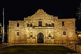
The Battle of the Alamo was a battle fought during the Texas Revolution.

<span class="mw-page-title-main">San Antonio River</span> River in US

The San Antonio River is a major waterway that originates in central Texas in a cluster of springs in midtown San Antonio, about 4 miles north of downtown, and follows a roughly southeastern path through the state. It eventually feeds into the Guadalupe River about 10 miles from San Antonio Bay on the Gulf of Mexico. The river is 240 miles long and crosses five counties: Bexar, Goliad, Karnes, Refugio, and Wilson.

<span class="mw-page-title-main">San Antonio Springs</span>

San Antonio Springs is a cluster of springs in Bexar County, Texas. These springs provide a large portion of the water for the San Antonio River, which flows from San Antonio to the Gulf of Mexico. The San Pedro Springs also feed into the San Antonio River.

<span class="mw-page-title-main">Robert H.H. Hugman</span> American architect

Robert H. H. Hugman was an American architect who designed the San Antonio River Walk.

<span class="mw-page-title-main">Shops at Rivercenter</span> Shopping mall in Texas, United States

The Shops at Rivercenter is a shopping mall located in Downtown San Antonio, Texas, United States along the city's River Walk. The anchor stores are H&M and AMC Theatres. It also includes a 38-story, 1,001-room Marriott hotel. It was purchased in 2005 by Ashkenazy Acquisition Corporation.

<span class="mw-page-title-main">Greater San Antonio</span> Metropolitan Statistical Area in Texas, United States

Greater San Antonio, officially designated San Antonio–New Braunfels, is an eight-county metropolitan area in the U.S. state of Texas defined by the Office of Management and Budget (OMB). The metropolitan area straddles South Texas and Central Texas and is on the southwestern corner of the Texas Triangle. The official 2020 U.S. census showed the metropolitan area's population at 2,558,143—up from a reported 1,711,103 in 2000—making it the 24th largest metropolitan area in the United States. Downtown Austin and Downtown San Antonio are approximately 80 miles (129 km) apart, and both fall along the Interstate 35 corridor. This combined metropolitan region of San Antonio–Austin has approximately 5 million people.

<span class="mw-page-title-main">Culture of San Antonio</span> Overview of the culture of San Antonio, Texas

The culture of San Antonio reflects the history and culture of one of the state's oldest and largest cities straddling the regional and cultural divide between South and Central Texas. Historically, San Antonio culture comes from a blend of Central Texas and South Texas (Southwestern) culture. Founded as a Spanish outpost and the first civil settlement in Texas, San Antonio is heavily influenced by Mexican American culture due to Texas formerly being part of Mexico and, previously, the Spanish Empire. The city also has significant German, Anglo, and African American cultural influences. San Antonio offers a host of cultural institutions, events, restaurants and nightlife in South Texas for both residents and visitors alike.

The city of San Antonio in the U.S. state of Texas is composed of a number of neighborhoods and districts, spreading out surrounding the central Downtown Area.

<span class="mw-page-title-main">Arneson River Theater</span>

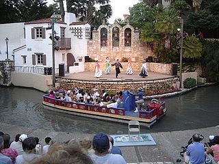
Arneson River Theater is an outdoor performance theater located on the San Antonio River Walk in the U.S. state of Texas.

<span class="mw-page-title-main">Downtown San Antonio</span> District of San Antonio

Downtown San Antonio is the central business district of San Antonio, Texas and the urban core of Greater San Antonio, a metropolitan area with nearly 2.5 million people.

<span class="mw-page-title-main">La Villita</span> United States historic place

La Villita Historic Arts Village is an art community in downtown San Antonio, Texas, United States. There are art galleries, stores selling souvenirs, gifts, custom jewelry, pottery, and imported Mexican folk art, as well as several restaurants in the district. La Villita connects to the San Antonio River Walk and its outdoor venue, the Arneson River Theatre. It is close to the Alamo, the Henry B. Gonzalez Convention Center, Rivercenter Mall, and HemisFair Park. It is within walking distance of most downtown hotels.

<span class="mw-page-title-main">San Antonio Marriott Rivercenter</span> High-rise hotel in San Antonio Texas

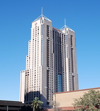
Marriott Rivercenter is a hotel located in San Antonio, Texas, USA. At a tip height of 546 feet, the 38-floor hotel is the tallest building in San Antonio and second tallest structure in the city. It is also the tallest hotel in Texas outside of Dallas. Its roof height, however, is 441 feet, 3 feet shorter than the Weston Centre.

<span class="mw-page-title-main">History of San Antonio</span> Aspect of Texas history

The City of San Antonio is one of the oldest Spanish settlements in Texas and was, for decades, its largest city. Before Spanish colonization, the site was occupied for thousands of years by varying cultures of indigenous peoples. The historic Payaya Indians were likely those who encountered the first Europeans.

<span class="mw-page-title-main">Architecture of San Antonio</span> Built environment in Texas

Architecture in the American city of San Antonio, Texas comes from a wide variety of sources, but many of the city's buildings mostly reflect Texas' Spanish and Mexican roots; with some influence from French builders, among others. Relatively rapid economic growth since the mid twentieth century has led to a fairly wide variety of contemporary architectural buildings.

<span class="mw-page-title-main">San Antonio Conservation Society</span> Nonprofit organization in Texas, U.S.

The Conservation Society of San Antonio is located in the Bexar County city of San Antonio in the U.S. state of Texas. Founding members were Emily Edwards, who became the organization's first president, and Rena Maverick Green. The organization was formed on March 22, 1924, and officially incorporated on July 8, 1925. The Society is currently headquartered in the Anton Wulff House, which they saved from destruction in 1974. The home was built 1869–1870 by German immigrant Anton Wulff, who became the city's first Park Commissioner.

<span class="mw-page-title-main">September 1921 San Antonio floods</span> Category 1 Atlantic hurricane in 1921

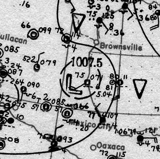
In early September 1921, the remnants of a Category 1 hurricane brought damaging floods to areas of Mexico and the U.S. state of Texas, particularly in the San Antonio region. On September 4, a tropical cyclone developed in the southwestern Gulf of Mexico near the Bay of Campeche. Moving slowly in a general westward direction, the disturbance reached hurricane intensity on September 7 prior to making landfall south of Tampico, Mexico the following day. The storm weakened over land, and lost cyclonic characteristics later that day. However, a nearby high-pressure area forced the remnants of the system northward into Texas. Due to an orographic lifting effect, the remnants were able to produce torrential and record rainfall over the state. Precipitation peaked over Central Texas, where the highest rainfall amount measured was 40 in (1,016 mm) near Thrall, Texas; this was the fourth-highest tropical cyclone-related rainfall total in Texas since record keeping began. Similarly, an observation of 36.40 in (925 mm) elsewhere in Williamson County, Texas ranked as the sixth-highest tropical cyclone-related rainfall total for the state. The high precipitation totals set nationwide records which would stand for several years.

Olmos Dam is a detention dam located in San Antonio, Texas. It was built in the 1920s, following the disastrous September 1921 San Antonio floods. Work began on the dam on January 19, 1925, completed in 1926, and in 1929 a cut-off channel, to allow excess water to bypass the Great Bend in downtown, was completed. Projects, which together have been providing flood control.

The San Antonio Downtown and River Walk Historic District is an amalgamation of residential and commercial sites. 197 contributing properties and 50 non-contributing properties were taken into consideration when evaluating the area for the National Register of Historic Places (NRHP) and also for the Recorded Texas Historic Landmarks (RTHL). The more than a century of economic growth and business/tourist development beginning in the mid-19th century is reflected in the city's architecture.

References

  1. Inside the Gates, Daughters of the Republic of Texas Library: San Antonio Flood of 1921. Drtlibrary.wordpress.com (September 24, 2010). Retrieved on 2013-05-04.
  2. "Olmos Dam". www.texasbeyondhistory.net. Retrieved April 28, 2019.
  3. San Antonio River Authority: Museum Reach. Sanantonioriver.org (May 30, 2009). Retrieved on 2013-05-04.
  4. "San Antonio's Pearl district: A gem of a 'hood".
  5. "La Vernia News". La Vernia News.
  6. San Antonio River Authority: Mission Reach Ecosystem Restoration and Recreation Project. Sanantonioriver.org. Retrieved on May 4, 2013.
  7. "Kayaking - Mission Adventure Tours - Kayaking in San Antonio". www.missionkayak.com.
  8. "Bike Tours - Mission Adventure Tours San Antonio Texas". www.missionbiketour.com.
  9. Centre, UNESCO World Heritage. "San Antonio Missions". whc.unesco.org.
  10. River Walk Drained; Mud Party To Follow KSAT News, San Antonio, Texas (January 6, 2009).
  11. Texas Travel: San Antonio's Riverwalk Mud Festival. Gotexas.about.com (April 9, 2012). Retrieved on 2013-05-04.
  12. Josh Baugh, "Go Rio wins barge contract: Council scorns Chicago-based firm backed by Sculley," San Antonio Express-News , May 26, 2017, pp. 1, A6.
  13. Mendoza, Madalyn (February 19, 2021). "Photos show people collecting water out of the S.A. River Walk". mySA. Retrieved February 22, 2021.
  14. Washburn, Mark. (April 27, 2012) Take a walk on the artsy, wild side of the greenway Archived January 16, 2013, at the Wayback Machine . Charlotte Observer. Retrieved on 2013-05-04.
  15. Searns, Robert (March 16, 2007) River walk to creekfront: Community perseverance pays off. American Trails Magazine. Retrieved on 2013-05-04.
  16. Luis Xavier Rangel-Ortiz (2008). Sociocultural Identity and Self Conceptualizations of Mexican Transnational Entrepreneurs (MTNE) in San Antonio, Texas. p. 5. ISBN   978-0-549-67593-8.
  17. "San Antonio Riverwalk", Texas Film Commission
  18. "Selena must-see landmarks highlight late star's ties to San Antonio", San Antonio Express News

29°25′31″N98°29′30″W / 29.425205°N 98.491575°W / 29.425205; -98.491575