Hurricane Earl (2010)

Last updated

Map key
  Tropical depression (≤38 mph, ≤62 km/h)
  Tropical storm (39–73 mph, 63–118 km/h)
  Category 1 (74–95 mph, 119–153 km/h)
  Category 2 (96–110 mph, 154–177 km/h)
  Category 3 (111–129 mph, 178–208 km/h)
  Category 4 (130–156 mph, 209–251 km/h)
  Category 5 (≥157 mph, ≥252 km/h)
  Unknown
Storm type
Disc Plain black.svg Tropical cyclone
Solid black.svg Subtropical cyclone
ArrowUp.svg Extratropical cyclone, remnant low, tropical disturbance, or monsoon depression

Earl formed in a well-organized area of low pressure and moved into the Atlantic Ocean as a vigorous tropical wave on early August 22. [1] After moving off the west coast of Africa, a surface low started to develop near the area of thunderstorms. [2] The surface low was able to organize the area of thunderstorms, allowing deep convection to occur near it. [3] Because of the area's increasing thunderstorm organization, the National Hurricane Center (NHC) indicated on August 24 that the system had a 90% chance of becoming a tropical depression within the next 48 hours. [4] 18 hours later, the NHC classified the system as Tropical Depression Seven at around 1500  UTC on August 25, while it was located about 430 mi (690 km) west of the southernmost Cape Verde Islands. [5] Six hours later, at about 2100 UTC, the system's maximum sustained winds were estimated to be 40 mph (64 km/h). Accordingly, the depression was declared to have become the fifth tropical storm of the season, and received the name Earl. [6]

Earl was forecast to head westward while gradually strengthening under the influence of low wind shear and warm ocean temperatures. [7] However, dry air caught in Earl's circulation precluded additional intensification, [8] causing the storm to maintain 45 mph (72 km/h) maximum sustained winds for 36 hours. [9] On August 29, the storm resumed gradual intensification, even though wind shear increased due to the outflow from nearby Hurricane Danielle. [10] The wind shear caused Earl's low level center of circulation to become exposed, limiting Earl's intensification to 60 mph (97 km/h) maximum sustained winds during the following 12 hours. [11] As the storm neared the Leeward Islands, convection increased around Earl and defined banding features formed. [12] Around 1230 UTC, Earl strengthened into a hurricane roughly 365 mi (587 km) east of the northern Leeward Islands. [13] Rapid intensification ensued throughout the day as a 35 mi (56 km) wide eye became apparent in radar imagery from Guadeloupe. [14] [15]

Satellite image of the North Atlantic Ocean on August 29 depicting hurricanes Danielle (top) and Earl (middle) as well as two tropical waves that would eventually develop into tropical storms Fiona and Gaston (right) Atlantic aug 29 2010 1445Z.jpg
Satellite image of the North Atlantic Ocean on August 29 depicting hurricanes Danielle (top) and Earl (middle) as well as two tropical waves that would eventually develop into tropical storms Fiona and Gaston (right)

Hurricane Earl's outflow steadily improved through August 30 and sustained winds rose above 100 mph (160 km/h), making Earl a Category 2 storm. [16] Around 1200 UTC, the center of Earl passed roughly 25 mi (40 km) east-northeast of St. Martin with sustained winds of 110 mph (180 km/h). [17] Several hours later, the storm further intensified into a major hurricane. [18] That afternoon, Earl became a Category 4 hurricane, attaining winds of 135 mph (217 km/h) before leveling out in intensity. [19] A northwestward track began to become apparent by this time as the system neared the southwestern periphery of a subtropical ridge over the Atlantic Ocean. [20] Early on August 31, an eyewall replacement cycle, a process in which a storm's eye dissipates and is replaced by a larger one, began to take place. [21] Despite increasing wind shear, the system maintained its intensity through September 1, [22] when it briefly weakened to a Category 3 system. [23] Gradual strengthening took place throughout the day as the eye became better defined and convection deepened around the center. Additionally, the storm began to turn northward in response to the ridge over the Atlantic and a strong trough over the Great Lakes. [24] Hurricane Earl later attained its peak intensity during the morning of September 2 with winds of 145 mph (233 km/h) and a barometric pressure of 928 mbar (hPa; 27.40 inHg). [25]

During the afternoon of September 2, Earl finally succumbed to the effects of increased shear and cooler water temperatures. Embedded within the mid-latitude westerlies, a gradual northeasterly turn was expected over the following day, preventing Earl from making landfall along the East Coast of the United States. [26] Around 0600 UTC the next morning, the storm made its closest approach to the United States, passing roughly 85 mi (137 km) east of Cape Hatteras, North Carolina with winds of 105 mph (169 km/h). [27] Further weakening took place throughout the day as convection weakened and the eye dissipated. [28] Earl was downgraded to a tropical storm that evening; however, the central pressure remained at an unusually low 958 mbar (hPa; 28.29 inHg). [29] At the same time, the storm made its closet approach to Massachusetts, passing roughly 90 mi (140 km) southeast of Nantucket. [30] Continuing northeastward, Earl neared the Canadian Maritimes, re-strengthening slightly and regaining hurricane intensity as it approached the region. The storm made landfall in Queens County near Western Head, Nova Scotia around 1400 UTC on September 4, as a Category 1 hurricane with sustained winds of 75 mph (121 km/h). [31] After crossing Prince Edward Island, the storm entered the Gulf of Saint Lawrence. There, the system finally transitioned into a post-tropical storm as its windfield became asymmetric and the eastern portion of the circulation became associated with a frontal system. [32] During the afternoon of September 5, the remnants of Earl were absorbed by a mid-latitude low roughly 205 mi (330 km) north-northeast of St. Anthony, Newfoundland. [33]

Research

Wave Height and Wind Speed of Hurricane Earl as measured by a three-day composite of data from NASA's Jason-1 and Ocean Surface Topography Mission (OSTM)/Jason-2 satellites, from Aug. 29 to Sept. 1, 2010. Hurricane Earl Wave Height Wind Speed.jpg
Wave Height and Wind Speed of Hurricane Earl as measured by a three-day composite of data from NASA's Jason-1 and Ocean Surface Topography Mission (OSTM)/Jason-2 satellites, from Aug. 29 to Sept. 1, 2010.

As Hurricane Earl tracked along the East Coast of the United States, a new program, the Genesis and Rapid Intensification Processes (GRIP), was launched. A former military aircraft, a WB-57 able to reach an altitude of 60,000 ft (18,000 m), carrying 15 new instruments was flown into the storm. Additionally, routine Hurricane Hunter missions were flown into Earl, a DC-8 and the first use of an unmanned research drone. Combined, these missions made Hurricane Earl the most studied tropical cyclone in history, according to Tim Miller, the lead scientist in GRIP. The outcome of the extensive research allowed for substantially improved forecasts during the latter part of Earl's existence. As compared to a similar storm, Hurricane Floyd in 1999, warnings covered roughly 1,500 mi (2,400 km) less coastline, saving residents and businesses roughly $1 billion in evacuation losses. [34]

In Anegada, a geological study, focusing on beach deposits from two significant wash-out events between 1650 and 1800, was given additional research material by the storm. Deposits left behind by the major hurricane were substantially less than the time period being studied. This led researchers to determine that a tsunami was likely the cause, rather than a hurricane. This also allowed for a connection to the 1755 Lisbon earthquake to be confirmed. [35]

Preparations

Caribbean

On August 27, France issued a tropical storm watch for the French side of Saint Martin and Saint Barthélemy. [36] The next day, Antigua and Barbuda and the Netherlands Antilles issued tropical storm watches for Antigua, Barbuda, Montserrat, St Kitts and Nevis and Anguilla and for Sint Maarten, Saba and Sint Eustatius. [37] Hours later, most of the watches were upgraded to tropical storm warnings; a tropical storm watch was also issued for the United States Virgin Islands. [38] By August 28, hurricane warnings were in place for the areas between Anguilla and Montserrat; hurricane watches were declared for the U.S. and British Virgin Islands as well as Puerto Rico. [39] As Earl moved closer to the northeastern Caribbean, warnings were extended westward through the Virgin Islands. [40]

Hurricane Earl as seen from the International Space Station on August 30 ISS024-E aug 30 2010 Hurricane Earl.jpg
Hurricane Earl as seen from the International Space Station on August 30

Throughout the Leeward Islands, heavy rains produced by the storm flooded low-lying areas. [41] During the late morning of August 30, some of the hurricane warnings were replaced by tropical storm warnings; the Turks and Caicos islands were also placed under a tropical storm watch. [42] Several hours later, all warnings for Antigua and Barbuda were discontinued. [43] That afternoon, all hurricane advisories were discontinued as Earl moved away from the Caribbean islands. [44] By August 31, the remaining advisories for the Caribbean were discontinued; the Turks and Caicos were also placed under a tropical storm warning. [45] Early on September 1, the Government of the Bahamas discontinued all advisories in relation to Hurricane Earl. [46]

Beginning on August 28, local governments placed emergency agencies on standby for possible damage from Hurricane Earl. Press releases were made to the public in order to give sufficient time for preparations. [47] The following day, emergency shelters were opened on Anguilla, Antigua, Barbuda, Montserrat, St. Kitts, Nevis and the Virgin Islands. On St. Kitts and Nevis, the Robert L. Bradshaw International Airport and Vance W. Amory International Airport were shut down and scheduled to re-open the following day. All emergency services were placed on standby on Anguilla, Antigua and Barbuda. [48] Prior to Earl's arrival in the Leeward Islands, the Leeward Islands Air Transport canceled 42 flights to and from the region. The V. C. Bird International Airport on Antigua was closed on August 29 and set to reopen after the storm passes. [49] Although not in the direct path of Hurricane Earl, officials in the Dominican Republic prompted evacuations of coastal towns and canceled flights across the country. [50]

United States

This animation shows the storm's progress and transformation between September 1 and September 3, 2010.

As Hurricane Earl moved away from the eastern Caribbean on August 31, the NHC began issuing storm watches for the United States East Coast. That day, a hurricane watch was issued for areas of North Carolina between Surf City and the Virginia border. A tropical storm watch was also issued south of this area to Cape Fear. [51] The next day, a hurricane warning was issued for parts of the North Carolina coastline between Bogue Banks to the Virginia border and the hurricane watch was extended northward to Cape Henlopen, Delaware. [52] Further watches and warnings were issued throughout the day, covering an increasingly large region of the coastline. [53] By September 2, these advisories encompassed much of the East Coast from Bogue Banks, North Carolina to the United States-Canada border in northern Maine. [54] According to the NHC, Earl was the first major hurricane to threaten New England since Hurricane Bob in 1991. [55] Cape Cod, Massachusetts was placed under a hurricane warning by this time and this remained in place until Earl was downgraded to a tropical storm the following day. [56] [57] The advisories gradually lessened in coverage as the storm moved away from the United States. The last warning in northern Maine remained in effect until the morning of September 4 when Earl approached landfall in Nova Scotia. [58]

On August 30, emergency officials in Massachusetts began early-stage emergency plans, ensuring that all communities had shelters, generators, sand bags and other disaster prevention materials. [59] Officials in New York and New Jersey also responded to the threat of Earl. Evacuation plans were readied for Long Island and New York City; emergency officers in New Jersey also discussed the possibility of evacuating residents from low-lying areas along the coastline. [60] Having experienced a fatality from a distant Hurricane Danielle earlier in August, officials in Maryland took the threat of Earl seriously. An estimated 250,000 people were expected to travel to the region for the Labor Day weekend, increasing the risk of loss of life from rip currents. Daily conference calls between state officials also began on August 30. In Suffolk County and Nassau County on Long Island, emergency officials prepared for winds in excess of 40 mph (64 km/h) and warned that evacuations were possible. [61] The Long Island Rail Road suspended service to the Hamptons before the storm. [62]

An administrator of the Federal Emergency Management Agency, Craig Fugate, cautioned that Earl's approach warranted a reminder for evacuation plans to be updated for the U.S. east coast, noting "It wouldn't take much to have the storm come ashore somewhere on the coast. The message is for everyone to pay attention." [63]

On August 31, mandatory evacuations began on North Carolina's Ocracoke Island. "I don't remember the last time there was a mandatory evacuation order for the island," stated Commissioner Kenneth Collier of Hyde County. Mandatory evacuations were also issued for Hatteras Island on September 1, with a total of 30,000 residents and visitors affected. [64] On September 1, state of emergency declarations were issued by the governors of Maryland, North Carolina, and Virginia. [65] [66] Naval Station Norfolk was put under orders to be ready to depart port within 24 hours if necessary. [66] The following day, Governor Deval Patrick declared a state of emergency for Massachusetts. [67] NSTAR deployed crews from Michigan to Cape Cod. The ferry to Nantucket was stopping service Friday morning. Chatham, Massachusetts was under a voluntary evacuation order. Several school districts in Rhode Island released students from school early on September 3, as well as Bristol-Warren and Cumberland school Districts, which closed schools in anticipation of Hurricane Earl. [68]

Canada

On September 2, the Canadian Hurricane Center issued a hurricane watch for areas in Nova Scotia between Medway Harbour and Digby as well as a tropical storm watch from the edges of the hurricane watch to Ecum Secum and Fort Lawrence. [69] Later that day, the tropical storm watch was expanded northward to Point Tupper and a new one was issued for Prince Edward Island and parts of eastern New Brunswick. [70] Early on September 3, a tropical storm warning was issued for areas between Lismore and Ecum Secum as well as Prince Edward Island. [71] The following day, the hurricane watch in Nova Scotia was shifted to include areas between Ecum Secum and Point Tupper and the tropical storm watch in New Brunswick was discontinued. [72] Later on September 4, much of Nova Scotia was under a tropical storm warning. [73] These warnings were later discontinued as Earl moved northward through Atlantic Canada; however, a new tropical storm warning was issued for parts of Newfoundland between Burgeo and Boat Harbour. [74] Following the storm's transition into an extratropical cyclone, all warnings were discontinued in Canada. [75]

Earl was predicted to have an 80% chance of striking Nova Scotia (60% chance as a hurricane) since the end of August. [76] [77] [78] This enabled emergency preparations to begin nearly a week before Earl made landfall. On September 2, the Red Cross placed over 900 volunteers on standby. [78] Because anticipated landfall would take place at low neap tide and storm surge would be minimal, no mandatory evacuation orders were issued, [78] although some marinas required boats to be moved to safer mooring. Tourists in the area were warned of the likely impact of the coming storm by the Department of Tourism, Culture and Heritage. [78] Virtually all permanent residents stayed and prepared to be without electricity for a couple of days. [79] While ferries in the area were cancelled, the Confederation Bridge linking New Brunswick and Prince Edward Island was not closed. However, high-sided vehicles and motorcycles were barred from crossing for six hours at the height of the storm. [80]

Impact

Caribbean

Hurricane Earl moving away from the Leeward Islands on August 30 Earl aug 30 2010.jpg
Hurricane Earl moving away from the Leeward Islands on August 30

Antigua and Barbuda

According to officials in Antigua and Barbuda, the entire island of Antigua was left without power due to Hurricane Earl. High winds felled numerous trees and signs as well as damaged homes. [81] At least one home was destroyed on the island, forcing the evacuation of eight people. [82] An estimated 7 inches (180 mm) of rain fell in the country, resulting in widespread flooding. In Bolans Village, seven people had to be rescued after wading into waist-deep water. Following the passage of Earl, Philmore Mullin, Director of the National Office of Disaster Services, expressed his concern for the lack of action taken by residents prior to the hurricane's arrival. A country-wide holiday was declared for August 30 by Governor General Dame Louise Lake-Tack to help cleanup efforts run more efficiently. Health officials advised residents to also boil their water to avoid water-borne diseases until further notice. [81] One person was killed in relation to the storm after being electrocuted while trying to restore power. [83]

Throughout Antigua and Barbuda, losses from the hurricane amounted to EC$34 million (US$12.6 million). [84] In the wake of Earl, the International Federation of Red Cross and Red Crescent Societies allocated roughly $50,000 (USD) in relief funds for the country. A three-month recovery operation was implemented within days of the storm's passage and focused on providing shelter and sustenance for the 1,000 families displaced by Earl. Additionally, economic assistance due to substantial crop losses was required, especially for families who depend on agriculture. [85]

Guadeloupe and the French islands

The highest winds recorded during Earl's passage in Guadeloupe was in the island of La Désirade, where sustained gust reached 73 mph (117 km/h), just below hurricane-force wind while in the northern French islands of Saint Barthelemy recorded 90 mph (140 km/h) in Saint Jean and 105 mph (169 km/h) in Gustavia as the minimal pressure fell to 989 mb. [86] In Saint Martin the highest gust reach 83 mph (134 km/h) on the French side as the minimal pressure record at 983.3 mb in Grand Case and the total rainfall was 98,0 mm. Across those islands of Saint Martin, Saint Barthelemy and Guadeloupe, 7,500 people were left without power. [87] In Sint Maarten, the highest gust observed was 88 mph (142 km/h). [88] Damages was moderate : trees and power lines were felled across the island, leaving most residents without power. [82] Some roof damage was sustained by homes on the island as well. [89]

Saint Kitts and Nevis

High winds and heavy rains, amounting to 3.82 in (97 mm), [90] battered St. Kitts and Nevis; two coast guard vessels were grounded on the islands. [91] Several streets were also flooded throughout the area. [92] Widespread power outages affected many residents on the island, some of whom remained without electricity for 24 hours. [90]

British Leeward Islands

On Dominica, three minor earthquakes, one measuring 2.7 on the Richter magnitude scale, struck the island during Earl's passage. [93] In Montserrat, moderate damage took place as a result of Earl. Torrential rains, amounting to 12 in (300 mm) triggered several landslides and flooding. No structural damage took place; however, roads, trees and power lines were impacted. [92] Initial assessments from officials indicated that losses reached EC$10 million (US$3.7 million). [83]

In the British territories of Anguilla and the British Virgin Islands, power and water supply was lost to the entire Territory; several vessels on Tortola were grounded. [94] On Anguilla, the highest wind gust reach 88 mph (142 km/h). Three homes were destroyed and 25 others were damaged by the storm. [83] Throughout the British Virgin Islands, losses amounted to $7 million. [95] Hotels throughout the area suffered extensive losses, with three losing $300,000 in damage. [96] In the wake of Earl, the Caribbean Catastrophe Risk Insurance Facility provided Anguilla with $4.3 million for cleanup and repair operations. [97]

Hurricane Earl
Earl 2010-09-02 0320Z.jpg
Earl at peak intensity near the Bahamas on September 2
Impact from Hurricane Earl
CountryState/RegionFatalitiesDamage (in USD)
Antigua and Barbuda 1$12.6 million
Canada1Unknown
United Kingdom Anguilla 0$4.3 million
Virgin Islands 0$7.3 million
Montserrat 0$3.7 million
Saint Kitts and Nevis 0Unknown
United StatesFlorida3Minimal
Georgia 0$8,000
Massachusetts 1$20,000
North Carolina 0$3.88 million
New Jersey 2Minimal
New York 0Unknown
South Carolina 0$14,000
Virgin Islands 0$13.2 million
Total8$44.98 million

Puerto Rico and the U.S. Virgin Islands

Throughout the United States Virgin Islands, high winds, gusting up to 69 mph (111 km/h), [98] and heavy rains, peaking at 3.02 in (77 mm) on St. Thomas, [99] caused significant damage to roadways and power lines. Many residents across the islands were left without power for up to a week as a result of the storm. Following an assessment of the damage, total losses were placed at $2.5 million, allowing the governor of the U.S. V.I. to request for a major disaster declaration from the United States government. This request was later approved by President Barack Obama in late September. [100] In addition to damage to infrastructure, severe losses were sustained in the business sector. As a result of Earl's passage through the region, nearly 22,000 vacationers canceled their plans, resulting in a $10.7 million loss in revenue. [101] In March 2011, the Federal Emergency Management Agency (FEMA) granted $555,219 in public assistance funding to cover the costs from Earl in the Virgin Islands. [102]

Heavy rains also began to affect Puerto Rico during the early afternoon on August 30 as Hurricane Earl moved closer to the island. [88] Throughout the island, a maximum of 5.19 in (132 mm) of rain fell near Naguabo. [99] In San Juan, 3.57 inches (91 mm) of rain fell during the passage of Earl. [103] [104] Dozens of roads were shut down across the island due to flooding and downed power lines. At the height of the storm, roughly 187,000 residences were left without power and 60,000 more were without water. [97] [105] A landslide triggered by heavy rains covered a portion of Puerto Rico Highway 191, temporarily closing the road. [106]

United States

Hurricane Earl off the Mid-Atlantic. Hurricane Earl 2010-09-03 1750Z.jpg
Hurricane Earl off the Mid-Atlantic.

Throughout the United States, damage from Hurricane Earl was generally minor. Insurance modelers for catastrophes estimated that losses from the storm would not exceed $100 million in the country. [107] According to the federal procurement data system, roughly $300,000 was given by FEMA in relief funds throughout the United States. [108]

Southeast

Off the coast of Florida, near the Bahamas, one person went missing and is believed to have drowned after encountering 30 m (98 ft) waves produced by Earl. [109] Near Jupiter Inlet, a man fell off his ship during rough seas. Lifeguards found him unconscious and transported him to a nearby hospital where he died on September 7. [110] On September 4, a third person died in Volusia County after being caught in a rip current; more than 200 rescues were made by lifeguards in the county during the day. [111] Persistent swells between 7 and 10 ft (2.1 and 3.0 m) in Tybee Island, Georgia resulted in severe beach erosion. Some places lost up to 20 ft (6.1 m) of beach, leaving $8,000 in losses. [112] On September 4, rip currents produced by Earl resulted in the rescue of 20 to 30 people on the island. [113] In parts of Charleston County, South Carolina, local beaches lost up to 40 ft (12 m) of sand due to Earl. Offshore, a sailors lost control of their boat amidst the rough seas and crashed into a pier, destroying the vessel. Losses in the state reached $14,000. [114] [115]

North Carolina

Although the center of Hurricane Earl passed roughly 100 mi (160 km) off the coast of North Carolina, its large size brought just under hurricane-force winds and a significant storm surge. [116] Heavy rains accompanied the storm, peaking at 4.52 in (115 mm) in Cape Hatteras. [117] The highest winds were recorded in Cape Hatteras at 67 mph (108 km/h) and gusts reached 83 mph (134 km/h); [118] however, there were few reports of damage in relation to the winds. [119] A storm surge of 4.7 ft (1.4 m) came ashore on Hatteras Island, inundating nearby areas. [118] Minor flooding took place along several roads, including North Carolina Highway 12 which was shut down on Hatteras Island. A pier at Atlantic Beach was also damaged by rough seas. [119] Numerous homes along the coast were flooded by rising waters, reaching 3 ft (0.91 m) in places. An estimated 6,600 residences were left without power due to Hurricane Earl. [120] Waves just offshore were measured between 25 and 36 ft (7.6 and 11.0 m), likely resulting in beach erosion. [121] In Manteo, a gas station lost its canopy and some homes lost roofing shingles due to high winds. [118] Damage in Dare County totaled over $500,000 (2010 USD), with 79 houses in the county sustaining minor damage and another six receiving major damage, mainly due to storm surge. [122] In neighboring Hyde County, strong winds caused about $2 million in crop damage. [123] Several homes were also damaged by fallen trees in the Fairfield and Swan Quarter areas. Throughout the state, damage from Earl amounted to $3.88 million, mainly from losses sustained by national parks and agriculture. [124] [125] Nearly two weeks after Earl's passage, the North Carolina Department of Transportation began to pick up debris left alongside roads in the wake of the storm. [126]

Mid-Atlantic

Rainfall from Hurricane Earl along the East Coast of the United States Earl2010filledrainblk.gif
Rainfall from Hurricane Earl along the East Coast of the United States

After brushing North Carolina, Hurricane Earl brought moderate rains and gusty winds to parts of Virginia. Although the center of the storm remained more than 100 mi (160 km) offshore, wind gusts reached 45 mph (72 km/h) in the state. Along the coast, large swells produced by the storm resulted in some beach erosion; however, no damage was reported. [127] Throughout Delaware, the threat of Hurricane Earl lessened Labor Day weekend tourism. Many hotels across the state reached occupancies of 40-60%, significantly lower than initially expected. [128] Along the coast, swells up to 6.02 ft (1.83 m) resulted in minor tidal flooding, though no damage took place. [129] Off the coast of New Jersey two people were killed after being swept out to sea by rip currents. [130] The bodies of both victims were found after they washed onshore days after Earl's passage. [131] The outer bands of Earl brought gusty winds and minimal rainfall, peaking at 0.22 in (5.6 mm) in Chatsworth. [132] Some beach erosion was reported along the coastline, with the worst being in Atlantic City. [133] At the city's Garden Pier, the Historical Museum and the Atlantic City Arts Center was shut down indefinitely after electrical lines and pipes were damaged by waves. [134] After nearly two weeks of beaches being shut down, swimmers were finally allowed to enter the water on September 5 throughout New Jersey. [135]

In Long Island, New York, heavy surf produced by Earl inundated much of Jones Beach State Park, leading to officials closing the area for several days. By September 6, flood waters brought onshore by the storm still remained in the area despite continuous efforts to drain the water. [136] Moderate beach erosion also took place in Robert Moses State Park. [137] Similar impacts were felt in The Hamptons as many roads were temporarily shut down due to flooding. [138] Rainfall from the storm peaked at 2.11 in (54 mm) just outside Jamesport. [132] Following the lack of damage caused by the storm, the Long Island Power Authority was criticized for excessive spending on emergency crews. An estimated $30 million was spent to bring in an additional 1,600 crewmen to deal with possible power outages despite forecasts showing Earl missing the state. Due to the excess funding, residents in New York were faced with increased rates for power. Additionally, New York senator Charles Fuschillo called for an audit of the power authority. [139] It was later determined that LIPA had "jumped the gun" on the situation and brought in the assistance without necessity. [140] In their defense, the agency claimed that "it [was] better to be safe than sorry", referring to the power outage following Hurricane Gloria in 1985 which affected parts of Long Island for over a week. [141]

New England

Chatham, Massachusetts Lighthouse during Earl on September 3 Earl in Chatham.JPG
Chatham, Massachusetts Lighthouse during Earl on September 3

On August 31, several days prior to Earl's passage, rough seas produced by the storm killed a man in Massachusetts after he was knocked off rocks and pulled out to sea. [142] Late on September 3, a weakened Tropical Storm Earl brushed New England, with its center passing roughly 90 mi (140 km) south-southeast of Nantucket, Massachusetts. [143] During the height of the storm, heavy rains and winds up to 58 mph (93 km/h) buffeted the coastline. [144] In Yarmouth, a total of 5.17 in (131 mm) of rain fell during the storm, the highest in the state. [145] Throughout the state, roughly 1,800 residences, roughly 600 of which were on Cape Cod, lost power due to downed trees and power lines. [146] In the local harbors, most boats were unaffected by the storm; however, one did capsize. [144] The most significant losses were to businesses who lost their Labor Day weekend revenue. Several hotels estimated that 10% of the revenue was lost, this equates to hundreds of thousands of dollars. [146] One hotel in Yarmouth reported an 80% decrease in attendance despite a price cut from $130 to $85. [147] On the other hand, supply stores saw improved sales, experiencing a 20% increase in revenues. [146] Due to the lack of major damage from the storm, most businesses reopened on September 4 and tourists resumed their weekend plans. [148] Throughout the state, Earl left $20,000 in damage. [149]

In parts of Rhode Island, coastal flooding inundated low-lying roads, leaving ocean debris behind. [150] Further north in Maine, the effects of Earl were limited to increased swells along the coast and moderate rainfall. [151] Several areas across the state measured over 2 in (51 mm) of rain, [152] with the highest total being measured at 4.28 in (109 mm) in Machias. [145] Winds in the state peaked between 35 and 40 mph (56 and 64 km/h), though no wind damage took place. [153] Prior to Earl's arrival, a dry spell left several brooks and streams nearly empty; however, the rainfall from the storm alleviated the drought conditions. Only one road experienced flooding as a result of the rains. [152] According to state transportation officials, northbound and southbound traffic along the Maine Turnpike was down 19% and 2.7% respectively, indicating that many tourists who were expected to travel to the region changed their plans. [154]

Canada

Hurricane Earl shortly after making landfall in Nova Scotia on September 4 Tropical Storm Earl 2010-09-04 1515Z.jpg
Hurricane Earl shortly after making landfall in Nova Scotia on September 4

Hurricane Earl came ashore in Queens County near Western Head, Nova Scotia on September 4 around 10:00 am (1400 UTC), as a category 1 storm with sustained winds of 75 mph (121 km/h). [155] [156] Just offshore, buoys recorded winds near hurricane-force and enormous waves up to 82 ft (25 m) tall. Onshore, strong winds and heavy rain affected much of Atlantic Canada; rainfall peaked at 3 inches (76 mm) in Edmundston, New Brunswick. [156] In Quebec, heavy rains from the storm amounted to at least 1.9 inches (48 mm); however, reports from a storm chaser indicate that up to 3.2 inches (81 mm) may have fallen in Passes-Dangereuses. [157] The strongest winds onshore reached 84 mph (135 km/h) on Beaver Island. [156] Sustained winds of at least 39 mph (63 km/h) likely affected all of Nova Scotia, Prince Edward Island, much of Newfoundland, and parts of eastern New Brunswick, as well as extreme eastern Quebec and Labrador. [158]

Throughout the affected region, about 252,000 residences, nearly one million people, were left without power as a result of Earl. [159] [160] Roughly 104,000 residences that lost power were in the Halifax metro area. The city received some of the worst impacts from the storm, experiencing near-hurricane-force winds around 12:00 pm (local time) on September 4. Several structures in the city were struck by fallen trees. At the height of the storm, Nova Scotia Routes 207, 331 and 333 were shut down due to flooding and downed power lines. [161] [162] Numerous trees and power lines were downed throughout Nova Scotia, blocking roads and damaging homes. [163] Earl's only fatality in Canada occurred when one man drowned while trying to retrieve a boat which had been dislodged from its moorings. [164]

Throughout Prince Edward Island, high winds left roughly 9,000 homes and businesses without power. Minor streets flooding and downed trees impeded travel throughout the area. [163] In New Brunswick, little damage took place during Earl's passage; some trees were downed, resulting in scattered power outages. [163] Along the St. George's Bay area in Newfoundland, numerous residents were left without power due to fallen trees and power lines. No injuries or major damage took place on the island and power was expected to be fully restored by the afternoon of September 5. [165] Intense winds produced by the storm felled numerous trees, some more than 100 years old, and damaged homes. [166]

Within hours of the storm's passage in Nova Scotia, hundreds of power crews were deployed to restore electricity as quickly as possible. Once winds dropped below 65 mph (105 km/h), roughly 400 crewmen began fixing damaged lines. [162] One lineman was injured after briefly coming into contact with live wires. Additional crews from New Brunswick, consisting of 18 trucks and 36 linemen, were deployed to the hardest hit regions. [163] Roughly 90,000 Nova Scotia residences had their electricity restored by 10:00 pm the same night. By the morning of September 5, about 92,000 residences remained without power across Nova Scotia. [167] It was not until September 7 that all residents affected by the storm had their power restored. [168]

See also

Related Research Articles

<span class="mw-page-title-main">Hurricane Lili</span> Category 4 Atlantic hurricane in 2002

Hurricane Lili was the second costliest, deadliest, and strongest hurricane of the 2002 Atlantic hurricane season, only surpassed by Hurricane Isidore, which affected the same areas around a week before Lili. Lili was the twelfth named storm, fourth hurricane, and second major hurricane of the 2002 Atlantic hurricane season. The storm developed from a tropical disturbance in the open Atlantic on September 21. It continued westward, affecting the Lesser Antilles as a tropical storm, then entered the Caribbean. As it moved west, the storm dissipated while being affected by wind shear south of Cuba, and regenerated when the vertical wind shear weakened. It turned to the northwest and strengthened up to category 2 strength on October 1. Lili made two landfalls in western Cuba later that day, and then entered the Gulf of Mexico. The hurricane rapidly strengthened on October 2, reaching Category 4 strength that afternoon. It weakened rapidly thereafter, and hit Louisiana as a Category 1 hurricane on October 3. It moved inland and dissipated on October 6.

<span class="mw-page-title-main">Hurricane Juan</span> Category 2 Atlantic hurricane in 2003

Hurricane Juan was a significant tropical cyclone which caused extensive damage to parts of Atlantic Canada, being the tenth named storm and the sixth hurricane of the 2003 Atlantic hurricane season. Juan formed southeast of Bermuda on September 24 from a tropical wave that had tracked across the subtropical Atlantic Ocean. It tracked northward and strengthened over the warm waters of the Gulf Stream, reaching Category 2 strength on the Saffir-Simpson hurricane scale on September 27. The hurricane peaked in intensity with sustained winds of 105 mph (169 km/h) that same day, losing some strength as it raced over cooler waters toward the coast of Nova Scotia, before making landfall between Shad Bay and Prospect in the Halifax Regional Municipality early on September 29 as a Category 2 hurricane with winds of 100 mph (160 km/h). Juan retained hurricane strength while travelling through Nova Scotia, though it would weaken into a Category 1 hurricane over Prince Edward Island. Juan would eventually be absorbed by another extratropical low on September 29 near Anticosti Island in the northern Gulf of Saint Lawrence.

<span class="mw-page-title-main">2004 Atlantic hurricane season</span>

The 2004 Atlantic hurricane season was a very deadly, destructive, and active Atlantic hurricane season, with over 3,200 deaths and more than $61 billion in damage. More than half of the 16 tropical cyclones brushed or struck the United States. Due to the development of a Modoki El Niño – a rare type of El Niño in which unfavorable conditions are produced over the eastern Pacific instead of the Atlantic basin due to warmer sea surface temperatures farther west along the equatorial Pacific – activity was above average. The season officially began on June 1 and ended on November 30, though the season's last storm, Otto, dissipated on December 3, extending the season beyond its traditional boundaries. The first storm, Alex, developed offshore of the Southeastern United States on July 31, one of the latest dates on record to see the formation of the first system in an Atlantic hurricane season. It brushed the Carolinas and the Mid-Atlantic, causing one death and $7.5 million (2004 USD) in damage. Several storms caused only minor damage, including tropical storms Bonnie, Earl, Hermine, and Matthew. In addition, hurricanes Danielle, Karl, and Lisa, Tropical Depression Ten, Subtropical Storm Nicole and Tropical Storm Otto had no effect on land while tropical cyclones. The season was the first to exceed 200 units in accumulated cyclone energy (ACE) since 1995, mostly from Hurricane Ivan, the storm produced the highest ACE. Ivan generated the second-highest ACE in the Atlantic, only behind 1899 San Ciriaco Hurricane.

<span class="mw-page-title-main">2003 Atlantic hurricane season</span>

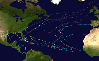
The 2003 Atlantic hurricane season was a very active season with tropical cyclogenesis occurring before and after the official bounds of the season—the first such occurrence since the 1970 season. The season produced 21 tropical cyclones, of which 16 developed into named storms; seven of those attained hurricane status, of which three reached major hurricane status. The strongest hurricane of the season was Hurricane Isabel, which reached Category 5 status on the Saffir–Simpson hurricane scale northeast of the Lesser Antilles; Isabel later struck North Carolina as a Category 2 hurricane, causing $3.6 billion in damage and a total of 51 deaths across the Mid-Atlantic region of the United States.

<span class="mw-page-title-main">2001 Atlantic hurricane season</span>

The 2001 Atlantic hurricane season was a fairly active Atlantic hurricane season that produced 17 tropical cyclones, 15 named storms, nine hurricanes, and four major hurricanes. The season officially lasted from June 1, 2001, to November 30, 2001, dates which by convention limit the period of each year when tropical cyclones tend to form in the Atlantic Ocean basin. The season began with Tropical Storm Allison on June 4, and ended with Hurricane Olga, which dissipated on December 6.

<span class="mw-page-title-main">1998 Atlantic hurricane season</span>

The 1998 Atlantic hurricane season was a catastrophic and deadly Atlantic hurricane season, featuring the highest number of storm-related fatalities in over 218 years and some of the costliest ever at the time. The season had above average activity, due to the dissipation of an El Niño event and transition to La Niña conditions. It officially began on June 1 and ended on November 30, dates which conventionally delimit the period during which most tropical cyclones form in the Atlantic Ocean. The season had a rather slow start, with no tropical cyclones forming in June. The first tropical cyclone, Tropical Storm Alex, developed on July 27, and the season's final storm, Hurricane Nicole, became extratropical on December 1.

<span class="mw-page-title-main">1992 Atlantic hurricane season</span>

The 1992 Atlantic hurricane season was a significantly below average season for overall tropical or subtropical cyclones as only ten formed. Six of them became named tropical storms, and four of those became hurricanes; one hurricane became a major hurricane. The season was also near-average in terms of accumulated cyclone energy. The season officially started on June 1 and officially ended on November 30. However, tropical cyclogenesis is possible at any time of the year, as demonstrated by formation in April of an unnamed subtropical storm in the central Atlantic.

<span class="mw-page-title-main">1991 Atlantic hurricane season</span>

The 1991 Atlantic hurricane season was the first season since 1984 in which no hurricanes developed from tropical waves, which are the source for most North Atlantic tropical cyclones. The hurricane season officially began on June 1, and ended on November 30. It was the least active in four years due to higher than usual wind shear across the Atlantic Ocean. The first storm, Ana, developed on July 2 off the southeast United States and dissipated without causing significant effects. Two other tropical storms in the season – Danny and Erika – did not significantly affect land. Danny dissipated east of the Lesser Antilles, and Erika passed through the Azores before becoming extratropical. In addition, there were four non-developing tropical depressions. The second depression of the season struck Mexico with significant accompanying rains.

<span class="mw-page-title-main">Hurricane Jeanne</span> Category 3 Atlantic hurricane in 2004

Hurricane Jeanne was a Category 3 hurricane that struck the Caribbean and the Eastern United States in September 2004. It was the deadliest hurricane in the Atlantic basin since Mitch in 1998, and the deadliest tropical cyclone worldwide in 2004. It was the tenth named storm, the seventh hurricane, and the fifth major hurricane of the season, as well as the third hurricane and fourth named storm of the season to make landfall in Florida. After wreaking havoc on Hispaniola, Jeanne struggled to reorganize, eventually strengthening and performing a complete loop over the open Atlantic. It headed westwards, strengthening into a Category 3 hurricane and passing over the islands of Great Abaco and Grand Bahama in the Bahamas on September 25. Jeanne made landfall later in the day in Florida just two miles from where Hurricane Frances had struck a mere three weeks earlier.

<span class="mw-page-title-main">Hurricane Marilyn</span> Category 3 Atlantic hurricane in 1995

Hurricane Marilyn was the most powerful hurricane to strike the Virgin Islands since Hurricane Hugo of 1989, and the third such tropical cyclone in roughly a two-week time span to strike or impact the Leeward Islands, the others being Hurricane Iris and the much more powerful and destructive Hurricane Luis. The thirteenth named storm, seventh hurricane and third major hurricane of the extremely active 1995 Atlantic hurricane season, Marilyn formed on September 12 as a tropical depression from a tropical wave that moved off the coast of Africa on September 7. After formation, the storm quickly became a tropical storm, and steadily intensified into a hurricane by the time it struck the Lesser Antilles on September 14 at Category 1 strength. Entering the northeastern Caribbean Sea, rapid intensification ensued and it peaked on September 16 north of Puerto Rico as a Category 3 hurricane shortly after it had impacted the U.S. Virgin Islands. A Hurricane Hunter reconnaissance flight reported hail, which is unusual for tropical cyclones. After heading north past Bermuda, Marilyn weakened and became extratropical on September 22. The remnant circulation wandered the Atlantic Ocean from September 23 – October 1, just south of Nova Scotia.

<span class="mw-page-title-main">Tropical Storm Helene (2000)</span> Atlantic tropical storm in 2000

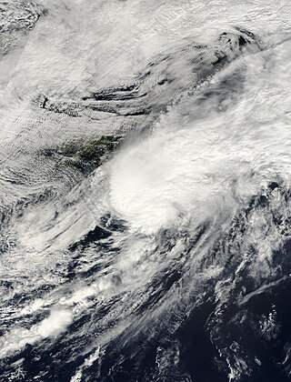
Tropical Storm Helene was a long-lived tropical cyclone that oscillated for ten days between a tropical wave and a 70 mph (110 km/h) tropical storm. It was the twelfth tropical cyclone and eighth tropical storm of the 2000 Atlantic hurricane season, forming on September 15 east of the Windward Islands. After degenerating into a tropical wave, the system produced flooding and mudslides in Puerto Rico. It reformed into a tropical depression on September 19 south of Cuba, and crossed the western portion of the island the next day while on the verge of dissipation. However, it intensified into a tropical storm in the Gulf of Mexico, reaching its peak intensity while approaching the northern Gulf Coast.

<span class="mw-page-title-main">Hurricane Felix</span> Category 5 Atlantic hurricane in 2007

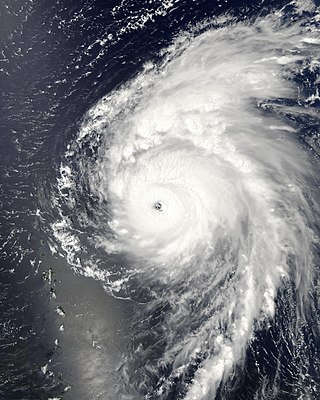
Hurricane Felix was an extremely powerful Category 5 Atlantic hurricane which was the southernmost-landfalling Category 5 storm on record, surpassing Hurricane Edith of 1971. It was the sixth named storm, second hurricane, and second Category 5 hurricane of the 2007 Atlantic hurricane season. Felix formed from a tropical wave on August 31, passing through the southern Windward Islands on September 1 before strengthening to attain hurricane status. On the next day, Felix rapidly strengthened into a major hurricane, and early on September 3 it was upgraded to Category 5 status; at 2100 UTC on the same day, the hurricane was downgraded to Category 4 status, but strengthened into a Category 5 hurricane for the second and final time by the morning of September 4.

<span class="mw-page-title-main">Hurricane Humberto (2007)</span> Category 1 Atlantic hurricane in 2007

Hurricane Humberto was a Category 1 hurricane that formed and intensified faster than any other North Atlantic tropical cyclone on record, before landfall. The eighth named storm and third hurricane of the 2007 Atlantic hurricane season, Humberto developed on September 12, 2007, in the northwestern Gulf of Mexico. The tropical cyclone rapidly strengthened and struck High Island, Texas, with winds of about 90 mph (140 km/h) early on September 13. It steadily weakened after moving ashore, and on September 14, Humberto began dissipating over northwestern Georgia as it interacted with an approaching cold front.

<span class="mw-page-title-main">Hurricane Bill (2009)</span> Category 4 Atlantic hurricane in 2009

Hurricane Bill was a large Atlantic hurricane that brought minor damage across mainly Atlantic Canada and the East Coast of the United States during August 2009. The second named storm, first hurricane, and first major hurricane of the 2009 Atlantic hurricane season, Bill originated from a tropical wave in the eastern Atlantic on August 15. Initially a tropical depression, the cyclone intensified within a favorable atmospheric environment, becoming Tropical Storm Bill six hours after formation. Steered west-northwest around the southern periphery of a subtropical ridge to the northeast of the cyclone, Bill passed through the central Atlantic. At 0600 UTC on August 17, the cyclone strengthened into a Category 1 hurricane on the Saffir–Simpson hurricane wind scale; within 36 hours, Bill entered a period of rapid deepening and intensified into a major hurricane with winds of 115 mph (185 km/h). Passing well northeast of the Lesser Antilles, Bill attained its peak intensity with maximum sustained winds of 130 mph (215 km/h) and a minimum barometric pressure of 943 mb on August 19 and August 20, respectively. Thereafter, an approaching trough induced higher vertical wind shear across the region, causing slow weakening of the hurricane; this same trough resulted in an accelerated motion and curve northward. As the storm passed Bermuda, it contained sustained winds equal to a Category 2, and ultimately struck Newfoundland as a tropical storm. After moving inland and weakening to a tropical storm, Bill began an extratropical transition; this alteration in structure was completed by 1200 UTC on August 24. Two days later, Bill's remnant low was absorbed into a larger extratropical system over the Northern Atlantic.

<span class="mw-page-title-main">Tropical Storm Erika (2009)</span> Atlantic tropical storm in 2009

Tropical Storm Erika was a short-lived tropical cyclone that brought minor impacts to the Lesser Antilles. The fifth named storm of the 2009 Atlantic hurricane season, Erika originated out of a tropical wave on September 1 near the Lesser Antilles. Although it was a disorganized system, it was immediately declared a tropical storm, rather than a tropical depression. Later that day, the system reached its peak intensity with winds of 50 mph (85 km/h) and a barometric pressure of 1004 mbar. Increased wind shear caused the storm to weaken shortly thereafter, with Erika barely maintaining tropical storm-status by September 2. Later that day, the storm passed over the island of Guadeloupe and entered the Caribbean Sea. On September 3, Erika weakened to a tropical depression as the low pressure center became fully displaced from convective activity. Later that day, the system degenerated into a remnant low before dissipating near Puerto Rico on September 4.

<span class="mw-page-title-main">Timeline of the 1998 Atlantic hurricane season</span>

The 1998 Atlantic hurricane season was an event in the annual tropical cyclone season in the north Atlantic Ocean. This Atlantic hurricane season saw an above-average number of named tropical storms, and included a single-day record for number of hurricanes simultaneously in progress, with four active on September 25: Georges, Ivan, Jeanne and Karl. The season officially began on June 1, 1998 and ended on November 30, 1998. These dates, adopted by convention, historically describe the period in each year when most tropical systems form. Even so, this season's first storm, Tropical Storm Alex, did not form until July 27, while its last, Hurricane Nicole, dissipated on December 1.

<span class="mw-page-title-main">Tropical Storm Bonnie (2010)</span> Atlantic tropical storm in 2010

Tropical Storm Bonnie was a small and rather weak tropical storm that brought squally weather to the northern Caribbean Sea and Gulf Coast of the United States in July 2010. The third tropical cyclone and second named storm of the 2010 Atlantic hurricane season, Bonnie developed from a tropical wave over the Bahamas on July 22. It strengthened to a tropical storm while crossing the islands, and made landfall on the southeastern coast of Florida the following day. Inland, Bonnie weakened to a tropical depression before entering the Gulf of Mexico, where its surface circulation dissipated on July 24. The remnants of the storm moved ashore between Louisiana and Mississippi early on July 25, prompting severe thunderstorm and tornado warnings in the area.

<span class="mw-page-title-main">Hurricane Leslie (2012)</span> Category 1 Atlantic hurricane in 2012

Hurricane Leslie was an Atlantic tropical cyclone that caused minor damage in Bermuda and Atlantic Canada in September 2012. The twelfth tropical cyclone of the annual hurricane season, Leslie developed from a tropical wave located nearly 1,500 miles (2,400 km) east of the Leeward Islands on August 30. About twelve hours later, it strengthened into Tropical Storm Leslie. Tracking steadily west-northwestward, it slowly intensified due to only marginally favorable conditions. By September 2, the storm curved north-northwestward while located north of the Leeward Islands. Thereafter, a blocking pattern over Atlantic Canada caused Leslie to drift for four days. Late on September 5, Leslie was upgraded to a Category 1 hurricane. However, due to its slow movement, the storm causing upwelling, which decreased sea surface temperatures (SST's), weakening Leslie back to a tropical storm on September 7.

<span class="mw-page-title-main">Hurricane Dorian</span> Category 5 Atlantic hurricane in 2019

Hurricane Dorian was an extremely powerful and catastrophic Category 5 Atlantic hurricane, which became the most intense tropical cyclone on record to strike the Bahamas, and is tied with the 1935 Labor Day hurricane for the strongest landfall in the Atlantic basin in terms of maximum sustained winds. The 2019 cyclone is regarded as the worst natural disaster in the Bahamas' recorded history. With winds peaking at 185 mph (295 km/h), it was also one of the most powerful hurricanes recorded in the Atlantic Ocean in terms of 1-minute sustained winds, and the strongest since Wilma in 2005. Dorian was the fourth named storm, second hurricane, the first major hurricane, and the first Category 5 hurricane of the 2019 Atlantic hurricane season. Dorian struck the Abaco Islands on September 1 with maximum sustained winds of 185 mph (295 km/h), tying with the 1935 Labor Day hurricane for the highest wind speeds of an Atlantic hurricane ever recorded at landfall. Dorian went on to strike Grand Bahama at similar intensity, stalling just north of the territory with unrelenting winds for at least 24 hours. The resultant damage to these islands was catastrophic; most structures were flattened or swept to sea, and at least 70,000 people were left homeless. After it ravaged through the Bahamas, Dorian proceeded along the coasts of the Southeastern United States and Atlantic Canada, leaving behind considerable damage and economic losses in those regions.

<span class="mw-page-title-main">Tropical Storm Chantal (2013)</span> Atlantic tropical storm in 2013

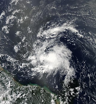
Tropical Storm Chantal was a significant tropical storm that brought strong winds and heavy rainfall to the Lesser Antilles and Hispaniola in July 2013. The third tropical depression, and the third tropical storm of the 2013 Atlantic hurricane season, Chantal originated from a tropical wave off the coast of Africa on July 4. By July 7, the wave had strengthened into a tropical storm, and had been named Chantal. On July 8 and 9, Chantal was speeding into a highly sheared area, however, Chantal later reached a peak intensity of 65 mph (105 km/h) and a pressure of 1,003 mbar (29.6 inHg). By July 10, an aircraft flew into the system and could not find a well-defined center and on July 12, it degenerated into an open wave.

References

  1. Felix Garcia (August 22, 2010). "Tropical Weather Discussion for the North Atlantic Ocean, August 22, 2010 8:05 am EST". National Hurricane Center. Retrieved August 29, 2010.
  2. Mike Forpemosa (August 23, 2010). "Tropical Weather Discussion for the North Atlantic Ocean, August 23, 2010 2:05 pm EST". National Hurricane Center. Retrieved August 29, 2010.
  3. Mike Formosa (August 24, 2010). "Tropical Weather Discussion for the North Atlantic Ocean, August 24, 2010 2:05 pm EST". National Hurricane Center. Retrieved August 29, 2010.
  4. Eric Blake (August 24, 2010). "Tropical Weather Discussion for the North Atlantic Ocean, August 24, 2010 8:00 pm EST". National Hurricane Center. Retrieved August 29, 2010.
  5. Lixion A. Avila (August 25, 2010). "Tropical Depression Seven Public Advisory One". National Hurricane Center. Retrieved August 29, 2010.
  6. Lixion A. Avila (August 25, 2010). "Tropical Storm Earl Public Advisory Two". National Hurricane Center. Retrieved August 29, 2010.
  7. Lixion A. Avila (August 25, 2010). "Tropical Storm Earl Discussion Two". National Hurricane Center. Retrieved August 29, 2010.
  8. Stacy Stewart (August 26, 2010). "Tropical Storm Earl Discussion Five". National Hurricane Center. Retrieved August 29, 2010.
  9. Lixion A. Avila (August 27, 2010). "Tropical Storm Earl Ten". National Hurricane Center. Retrieved August 29, 2010.
  10. Eric S. Blake (August 27, 2010). "Tropical Storm Earl Discussion Eleven". National Hurricane Center. Retrieved August 29, 2010.
  11. Lixion A. Avila (August 28, 2010). "Tropical Storm Earl Discussion Fourteen". National Hurricane Center. Retrieved August 29, 2010.
  12. Daniel Brown; Robbie Berg (August 29, 2010). "Hurricane Earl Discussion Seventeen". National Hurricane Center. Retrieved September 16, 2010.
  13. Daniel Brown (August 29, 2010). "Hurricane Earl Tropical Cyclone Update". National Hurricane Center. Retrieved September 16, 2010.
  14. Daniel Brown and Robbie Berg (August 29, 2010). "Hurricane Earl Discussion Eighteen". National Hurricane Center. Retrieved September 16, 2010.
  15. Richard J. Pasch (August 29, 2010). "Hurricane Earl Discussion Nineteen". National Hurricane Center. Retrieved September 16, 2010.
  16. Michael Brennan (August 30, 2010). "Hurricane Earl Discussion Twenty". National Hurricane Center. Retrieved September 16, 2010.
  17. Daniel Brown and Robbie Berg (August 30, 2010). "Hurricane Earl Public Advisory Twenty-A". National Hurricane Center. Retrieved September 16, 2010.
  18. Daniel Brown (August 30, 2010). "Hurricane Earl Public Advisory Twenty-One". National Hurricane Center. Retrieved September 16, 2010.
  19. Daniel Brown and Richard J. Pasch (August 30, 2010). "Hurricane Earl Public Advisory Twenty-Two". National Hurricane Center. Retrieved September 16, 2010.
  20. Daniel Brown (August 30, 2010). "Hurricane Earl Discussion Twenty-Two". National Hurricane Center. Retrieved September 16, 2010.
  21. Jack L. Beven (August 31, 2010). "Hurricane Earl Discussion Twenty-Four". National Hurricane Center. Retrieved September 16, 2010.
  22. Richard J. Pasch and Todd L. Kimberlain (August 31, 2010). "Hurricane Earl Discussion Twenty-Seven". National Hurricane Center. Retrieved September 16, 2010.
  23. Jack L. Beven (September 1, 2010). "Hurricane Earl Discussion 28". National Hurricane Center. Retrieved September 16, 2010.
  24. Richard J. Pasch (September 1, 2010). "Hurricane Earl Discussion Thirty-One". National Hurricane Center. Retrieved September 16, 2010.
  25. Jack L. Beven (September 2, 2010). "Hurricane Earl Public Advisory Thirty-Two". National Hurricane Center. Retrieved September 16, 2010.
  26. Lixion A. Avila (September 2, 2010). "Hurricane Earl Discussion Thirty-Four". National Hurricane Center. Retrieved September 16, 2010.
  27. Jack L. Beven (September 3, 2010). "Hurricane Earl Public Advisory Thirty-Six". National Hurricane Center. Retrieved September 16, 2010.
  28. Lixion A. Avila (September 3, 2010). "Hurricane Earl Discussion Thirty-Seven". National Hurricane Center. Retrieved September 16, 2010.
  29. Michael Brennan (September 3, 2010). "Tropical Storm Earl Discussion Thirty-Nine". National Hurricane Center. Retrieved September 16, 2010.
  30. Michael Brennan (September 3, 2010). "Tropical Storm Earl Public Advisory Thirty-One". National Hurricane Center. Retrieved September 16, 2010.
  31. Cangialosi, John P. (January 13, 2011). "Hurricane Earl Tropical Cyclone Report" (PDF). National Hurricane Center. Retrieved January 18, 2011.
  32. Michael Brennan (September 4, 2010). "Post-Tropical Storm Earl Discussion Forty-Three". National Hurricane Center. Retrieved September 16, 2010.
  33. Forecaster Miller (September 5, 2010). "Post-Tropical Storm Earl Final Advisory". Canadian Hurricane Centre. Archived from the original on June 11, 2011. Retrieved September 16, 2010.
  34. Eirc Berger (September 11, 2010). "Sizing up storms". The Houston Chronicle. Archived from the original on October 18, 2010. Retrieved October 5, 2010.
  35. Department of Disaster Management (February 16, 2011). "Scientists Report on Anegada Geological Findings". Virgin Islands Platinum News. Archived from the original on May 22, 2024. Retrieved March 13, 2011.
  36. Lixion A. Avila. "Tropical Storm Earl Public Advisory Number Ten". National Hurricane Center. Retrieved August 29, 2010.
  37. John Cangialosi and Michael Brennan. "Tropical Storm Earl Public Advisory Number Twelve". National Hurricane Center. Retrieved August 29, 2010.
  38. Lixion A. Avila (August 28, 2010). "Tropical Storm Earl Public Advisory Fourteen". National Hurricane Center. Retrieved September 15, 2010.
  39. Daniel Brown (August 28, 2010). "Tropical Storm Earl Public Advisory Sixteen-A". National Hurricane Center. Retrieved September 15, 2010.
  40. Michael Brennan (August 30, 2010). "Hurricane Earl Public Advisory Twenty". National Hurricane Center. Retrieved September 15, 2010.
  41. Staff Writer (August 30, 2010). "AP Top News at 8:10 am. EDT". Associated Press. Archived from the original on May 22, 2024. Retrieved August 30, 2010.
  42. Daniel Brown (August 30, 2010). "Hurricane Earl Public Advisory Twenty-One". National Hurricane Center. Retrieved September 15, 2010.
  43. Daniel Brown and Robbie Berg (August 30, 2010). "Hurricane Earl Public Advisory Twenty-One A". National Hurricane Center. Retrieved September 15, 2010.
  44. Daniel Brown and Richard J. Pasch (August 30, 2010). "Hurricane Earl Public Advisory Twenty-Two". National Hurricane Center. Retrieved September 15, 2010.
  45. Lixion A. Avila (August 31, 2010). "Hurricane Earl Public Advisory Twenty-Four A". National Hurricane Center. Retrieved September 15, 2010.
  46. Jack L. Beven (September 1, 2010). "Hurricane Earl Public Advisory Twenty-Eight". National Hurricane Center. Retrieved September 15, 2010.
  47. Staff Writer (August 28, 2010). "CDEMA Information Note # 1 – Hurricane Earl (Saturday, August 28, 2010)". Caribbean Disaster Emergency Management Agency. Archived from the original on August 24, 2016. Retrieved October 9, 2010.
  48. Staff Writer (August 29, 2010). "CDEMA Information Note # 2 – Hurricane Earl (Sunday, August 29, 2010)". Caribbean Disaster Emergency Management Agency. Archived from the original on March 28, 2016. Retrieved October 9, 2010.
  49. Staff Writer (August 29, 2010). "Hurricane Earl nears Antigua and Barbuda". Caribbean 360. Archived from the original on September 1, 2010. Retrieved August 30, 2010.
  50. Zhang Xu (August 30, 2010). "Dominican Republic Evacuates Towns, Suspends Flights due to Hurricane Earl". Xinhua. Archived from the original on November 19, 2018. Retrieved August 30, 2010.
  51. Lixion A. Avila (August 31, 2010). "Hurricane Earl Public Advisory Twenty-Six". National Hurricane Center. Retrieved January 7, 2011.
  52. Lixion A. Avila (September 1, 2010). "Hurricane Earl Public Advisory Twenty-Nine". National Hurricane Center. Retrieved January 7, 2011.
  53. Lixion A. Avila (September 1, 2010). "Hurricane Earl Public Advisory Thirty". National Hurricane Center. Retrieved January 7, 2011.
  54. Lixion A. Avila (September 2, 2010). "Hurricane Earl Public Advisory Thirty". National Hurricane Center. Retrieved January 7, 2010.
  55. "Hurricane Earl approaches East Coast". Los Angeles Times. September 1, 2010. Archived from the original on September 5, 2010. Retrieved September 1, 2010.
  56. Lixion A. Avila (September 2, 2010). "Hurricane Earl Public-Advisory Thirty-Three". National Hurricane Center. Retrieved January 7, 2011.
  57. Michael Brennan (September 3, 2010). "Tropical Storm Earl Public Advisory Thirty-Nine". National Hurricane Center. Retrieved January 7, 2011.
  58. Lixion A. Avila (September 4, 2010). "Tropical Storm Earl Public Advisory Forty-A". National Hurricane Center. Retrieved January 7, 2011.
  59. Laura Crimaldi (August 30, 2010). "Massachusetts officials prepare for possible brush with hurricane". The Boston Herald. Archived from the original on September 1, 2010. Retrieved August 30, 2010.
  60. Chris Herring and Erik Holm (August 30, 2010). "Greater New York Keeps Eye on Hurricane Earl". The Wall Street Journal. Archived from the original on September 2, 2010. Retrieved August 30, 2010.
  61. Frank D. Roylance (August 30, 2010). "Ocean City braces for Hurricane Earl". The Baltimore Sun. Archived from the original on August 13, 2017. Retrieved August 30, 2010.
  62. "LIRR Cancels Train Service to Hamptons Due to Hurricane Earl". DNAinfo. September 2, 2010. Retrieved May 27, 2024.
  63. "Earl batters Caribbean, threatens East Coast". msnbc. August 30, 2010. Archived from the original on May 22, 2024. Retrieved August 31, 2010.
  64. "Hurricane Earl Evacuations: Ocracoke Island In Hurricane Earl Path". The Huffington Post. September 1, 2010. Archived from the original on September 6, 2010. Retrieved September 1, 2010.
  65. Staff writer (September 1, 2010). "Earl prompts NC gov to declare State of Emergency". WMBF-TV . Archived from the original on September 15, 2010. Retrieved September 1, 2010.
  66. 1 2 Leezel Tanglao (September 1, 2010). "Hurricane Earl Triggers Virginia State of Emergency, Carolina Evacuations". ABC News . Archived from the original on September 4, 2010. Retrieved September 1, 2010.
  67. Staff writer (September 2, 2010). "With Earl approaching, Mass. governor declares state of emergency". Boston Globe . Archived from the original on September 4, 2010. Retrieved September 2, 2010.
  68. CNN Wire Staff (September 2, 2010). "At Category 2, Hurricane Earl spins off North Carolina". CNN.com . Archived from the original on July 25, 2018. Retrieved September 3, 2010.{{cite news}}: |author= has generic name (help)
  69. Lixion A. Avila (September 2, 2010). "Hurricane Earl Public Advisory Thirty-Three A". National Hurricane Center. Retrieved December 30, 2010.
  70. Michael Brennan and Robbie Berg (September 2, 2010). "Hurricane Earl Public Advisory Thirty-Five". National Hurricane Center. Retrieved December 30, 2010.
  71. Jack L. Beven (September 3, 2010). "Hurricane Earl Public Advisory Thirty-Six". National Hurricane Center. Retrieved December 30, 2010.
  72. Lixion A. Avila (September 4, 2010). "Tropical Storm Earl Public Advisory Forty A". National Hurricane Center. Retrieved December 30, 2010.
  73. Lixion A. Avila and Eric S. Blake (September 4, 2010). "Tropical Storm Earl Public Advisory Forty-One A". National Hurricane Center. Retrieved December 30, 2010.
  74. Lixion A. Avila and Eric S. Blake (September 4, 2010). "Tropical Storm Earl Public Advisory Forty-Two". National Hurricane Center. Retrieved December 30, 2010.
  75. Michael Brennan (September 4, 2010). "Tropical Storm Earl Public Advisory Forty-Three". National Hurricane Center. Retrieved December 30, 2010.
  76. Mark Sudduth (August 30, 2010). "Earl close to being a category three as it lashes northern Caribbean islands – up next, possible hurricane conditions along portions of the East Coast to Nova Scotia". Archived from the original on August 31, 2010. Retrieved September 6, 2010.
  77. Staff Writer (September 2, 2010). "Hurricane watch closes N.S. parks". Canadian Broadcasting Corporation.
  78. 1 2 3 4 Staff Writer (September 2, 2010). "Provincial Release at 5:00 pm ADT From Emergency Management Office". Haligonia.ca. Archived from the original on September 2, 2010. Retrieved September 6, 2010.
  79. Oliver Moore (September 3, 2010). "Earl won't budge Nova Scotia residents". Globe and Mail.
  80. Staff Writer (September 5, 2010). "Earl leaves thousands without power". Canadian Broadcasting Corporation.
  81. 1 2 Staff Writer (August 30, 2010). "Antigua counting the cost of Hurricane Earl". Go Jamaica. Archived from the original on September 1, 2010. Retrieved August 30, 2010.
  82. 1 2 Mike Melia (August 30, 2010). "Hurricane Earl lashes Caribbean, threatens US". Associated Press. Archived from the original on September 2, 2010. Retrieved August 30, 2010.
  83. 1 2 3 Caribbean Disaster Emergency Management Agency (September 1, 2010). "CDEMA Situation Report No. 3 – Hurricane Earl". ReliefWeb. Retrieved September 15, 2010.
  84. Staff Writer (October 5, 2010). "Hurricane Earl damages amount to $34M, report finds". Antigua Observer. Archived from the original on July 3, 2011. Retrieved October 5, 2010.
  85. "Antigua and Barbuda: Hurricane Earl" (PDF). International Federation of Red Cross and Red Crescent Societies. September 6, 2010. Retrieved September 15, 2010.
  86. "PASSAGE DE L'OURAGAN EARL SUR LA GUADELOUPE Et LES ILES DU NORD" (PDF). Meteo France. August 2010. Retrieved February 21, 2024.
  87. Staff Writer (August 30, 2010). "US braces for Hurricane Earl". Al Jazeera. Archived from the original on September 1, 2010. Retrieved August 30, 2010.
  88. 1 2 Henry Margusity (August 30, 2010). "Hurricane Earl Hitting the Virgin Islands and Flooding Puerto Rico". Accuweather. Archived from the original on September 1, 2010. Retrieved August 30, 2010.
  89. The Associated Press (August 30, 2010). "Category 4 Earl batters northeast Caribbean". The Jamaica Observer. Archived from the original on September 1, 2010. Retrieved August 30, 2010.
  90. 1 2 Sheena Brooks (September 3, 2010). "Back on Track After Hurricane Earl". The St. Kitts-Nevis Observer. Archived from the original on December 1, 2010. Retrieved September 15, 2010.
  91. CMC (August 31, 2010). "Caribbean countries cleaning up after close encounter with Earl". Jamaica Observer. Archived from the original on September 3, 2010. Retrieved August 31, 2010.
  92. 1 2 Caribbean Disaster Emergency Management Agency (August 31, 2010). "CDEMA Situation Report No. 2 – Hurricane Earl". ReliefWeb. Retrieved September 15, 2010.
  93. Geno Marcello (September 3, 2010). "Hurricane Earl Rips Through the Islands". The St. Kitts-Nevis Observer. Archived from the original on September 9, 2010. Retrieved September 15, 2010.
  94. Melissa French (September 1, 2010). "Damage Assessment Following Hurricane Earl". Virgin Islands Platinum News. Archived from the original on March 4, 2016. Retrieved September 1, 2010.
  95. Melissa French (October 8, 2010). "Earl Cost Gov't $7M; Recent Flood to Cost More". Virgin Islands Platinum News. Archived from the original on May 21, 2024. Retrieved October 8, 2010.
  96. Fareeza Haniff (September 8, 2010). "Cost from Hurricane Earl adding up". The Virgin Island Stand Point. Archived from the original on September 19, 2016. Retrieved October 5, 2010.
  97. 1 2 Gay Nagle Myers (September 1, 2010). "Hurricane Earl does damage in Anguilla". Travel Weekly. Archived from the original on January 16, 2017. Retrieved September 10, 2010.
  98. "US Virgin Islands Event Report: Tropical Storm". National Climatic Data Center. 2010. Archived from the original on May 22, 2024. Retrieved November 19, 2010.
  99. 1 2 David M. Roth (2010). "Hurricane Earl – August 29-September 4, 2010". Hydrometeorological Prediction Center. Retrieved October 5, 2010.
  100. Aldeth Lewin (September 30, 2010). "Obama declares Earl a V.I. disaster, allowing federal aid". Virgin Island Daily News. Archived from the original on May 22, 2024. Retrieved October 5, 2010.
  101. Joy Blackburn (September 15, 2010). "V.I. can feel economic winds from hurricanes far from territory". Virgin Island Daily News. Archived from the original on September 30, 2010. Retrieved October 5, 2010.
  102. Daniel Shea (March 4, 2011). "FEMA awards V.I. $555,219 to cover damage from Hurricane Earl". Virgin Island Daily News. Archived from the original on March 8, 2011. Retrieved March 13, 2011.
  103. Resident of San Juan, Puerto Rico (August 30, 2010). "Daily Weather Summary for San Juan, Puerto Rico: August 30, 2010". Weather Underground. Archived from the original on June 30, 2012. Retrieved August 30, 2010.
  104. Resident of San Juan, Puerto Rico (August 31, 2010). "Daily Weather Summary for San Juan, Puerto Rico: August 30, 2010". Weather Underground. Archived from the original on June 30, 2012. Retrieved August 31, 2010.
  105. Celso Hernandez (August 31, 2010). "Hurricane Earl- Aftermath Arecibo". Caribbean Hurricane Network. Retrieved August 31, 2010.
  106. "Puerto Rico Event Report: Landslide". National Climatic Data Center. 2010. Archived from the original on May 22, 2024. Retrieved November 19, 2010.
  107. Mark A. Hofmann (September 3, 2010). "U.S. insured losses from Hurricane Earl limited: Modelers". Business Insurance. Archived from the original on May 22, 2024. Retrieved September 5, 2010.
  108. "Hurricane Earl Contract Actions" (XLS). Federal Procurement Data System. 2010. Retrieved October 29, 2010.
  109. David Landes (September 5, 2010). "Swedish sailor missing after tropical storm Earl". The Local. Archived from the original on October 3, 2010. Retrieved October 5, 2010.
  110. "Florida Even Report: High Surf". National Climatic Data Center. 2011. Retrieved January 6, 2011.
  111. "Florida Event Report: Rip Current". National Climatic Data Center. 2011. Retrieved January 6, 2011.
  112. "Georgia Event Report: High Surf". National Climatic Data Center. 2011. Retrieved January 6, 2011.
  113. "Georgia Event Report: Rip Current". National Climatic Data Center. 2011. Retrieved January 6, 2011.
  114. "South Carolina Event Report: High Surf". National Climatic Data Center. 2011. Retrieved January 6, 2011.
  115. "South Carolina Event Report: High Surf". National Climatic Data Center. 2011. Retrieved January 6, 2011.
  116. "North Carolina Event Report: Tropical Storm". National Climatic Data Center. 2011. Retrieved January 7, 2011.
  117. Roth, David M (May 12, 2022). "Tropical Cyclone Rainfall in the Southeastern United States". Tropical Cyclone Rainfall. United States Weather Prediction Center. Retrieved January 6, 2023.PD-icon.svg This article incorporates text from this source, which is in the public domain.
  118. 1 2 3 "National Weather Service Statements for Hurricane Earl in North Carolina". National Weather Service in Morehead City, North Carolina. September 3, 2010. Archived from the original on July 25, 2018. Retrieved September 15, 2010.
  119. 1 2 The Associated Press (September 3, 2010). "Little damage reported as Hurricane Earl passes North Carolina coast". KSDK5. Archived from the original on September 3, 2010. Retrieved September 3, 2010.
  120. The Associated Press (September 3, 2010). "Earl Brings Minor Damage, Outages To Coast". WSOC9. Archived from the original on September 3, 2010. Retrieved September 3, 2010.
  121. The Associated Press and Reuters (September 3, 2010). "Earl lashes N.C. coast, officials survey damage". NBC News. Retrieved September 3, 2010.{{cite web}}: |author= has generic name (help)
  122. "North Carolina Event Report: Tropical Storm". National Climatic Data Center. 2011. Retrieved January 7, 2011.
  123. John A. Cole (September 11, 2010). "Post Tropical Cyclone Report...Hurricane Earl...Updated". Newport/Morehead City, NC National Weather Service. Archived from the original on June 11, 2011. Retrieved September 20, 2010.
  124. "North Carolina Event Report: Tropical Storm". National Climatic Data Center. 2011. Retrieved January 7, 2011.
  125. Erin James (October 17, 2010). "North Carolina paid high price for Earl's visit". The Virginian-Pilot. Archived from the original on October 20, 2010. Retrieved October 29, 2010.
  126. The Associated Press (September 14, 2010). "NC Department of Transportation will pick up Hurricane Earl-related debris in coastal county". Fox News. Archived from the original on September 15, 2010. Retrieved September 15, 2010.
  127. Dena Potter (September 3, 2010). "Hurricane Earl Makes A Quiet Pass By Virginia". WJZ13 CBS. Archived from the original on May 22, 2024. Retrieved September 15, 2010.
  128. The Associated Press (September 3, 2010). "Delaware hotel occupancy rates down due to Earl". The Victoria Advocate. Archived from the original on August 12, 2017. Retrieved September 16, 2010.
  129. "Delaware Event Report: High Surf". National Climatic Data Center. 2011. Retrieved January 6, 2010.
  130. Joseph De Avila (September 4, 2010). "Earl Weakens, Claims Victim". The Wall Street Journal. Archived from the original on September 6, 2010. Retrieved September 9, 2010.
  131. Staff Writer (September 5, 2010). "Body of Missing Swimmer Recovered". Fox News. Archived from the original on August 12, 2017. Retrieved September 9, 2010.
  132. 1 2 Roth, David M (May 12, 2022). "Tropical Cyclone Rainfall in the Mid-Atlantic United States". Tropical Cyclone Rainfall. United States Weather Prediction Center. Retrieved January 6, 2023.PD-icon.svg This article incorporates text from this source, which is in the public domain.
  133. Anthony R. Wood and Jacqueline L. Urgo (September 4, 2010). "Earl spares Jersey Shore". The Philadelphia Inquirer. Archived from the original on September 7, 2010. Retrieved September 16, 2010.
  134. Staff Writer (September 17, 2010). "Hurricane Earl damage closes Atlantic City's Garden Pier". New Jersey On-Line. Archived from the original on September 20, 2010. Retrieved November 19, 2010.
  135. The Associated Press (September 5, 2010). "Most N.J. beaches permitting swimming". The New Jersey Star-Ledger. Archived from the original on September 8, 2010. Retrieved September 16, 2010.
  136. Staff Writer (September 6, 2010). "Jones Beach Still Flooded, Thanks To Earl". CBS2 News. Archived from the original on September 9, 2010. Retrieved September 6, 2010.
  137. The Associated Press (September 4, 2010). "Earl Packed Less Force Than Feared". My Fox NY. Archived from the original on September 5, 2010. Retrieved September 16, 2010.
  138. "New York Event report: High Surf". National Climatic Data Center. 2011. Retrieved January 7, 2011.
  139. Staff Writer (September 13, 2010). "Sen. Fuschillo calls for audit of LIPA's $30M Earl bill". The Long Island Herald. Archived from the original on April 26, 2023. Retrieved September 15, 2010.
  140. Mark Harrington (October 28, 2010). "LIPA jumped gun on Hurricane Earl staffing". Newsday. Archived from the original on November 1, 2010. Retrieved October 29, 2010.
  141. Karl Grossman (September 16, 2010). "'Better safe than sorry' is the right approach for LIPA". Shelter Island Report. Archived from the original on September 18, 2010. Retrieved October 29, 2010.
  142. Ron Sanders (August 31, 2010). "Man Drowns After Waves Sweep Him Off Rocks". WBZ38. Archived from the original on September 3, 2010. Retrieved September 9, 2010.
  143. Michael Brennan (September 3, 2010). "Tropical Storm Earl Public Advisory Thirty-Nine". National Hurricane Center. Retrieved September 9, 2010.
  144. 1 2 Brian MacQuarrie and Martin Finucane (September 4, 2010). "Earl doesn't lay a glove on Mass". The Boston Globe. Archived from the original on September 7, 2010. Retrieved September 9, 2010.
  145. 1 2 Roth, David M (May 12, 2022). "Tropical Cyclone Rainfall for the New England United States". Tropical Cyclone Rainfall. United States Weather Prediction Center. Retrieved January 6, 2023.PD-icon.svg This article incorporates text from this source, which is in the public domain.
  146. 1 2 3 Jessica Fargen (September 5, 2010). "Cape weathers weakened Hurricane Earl". The Boston Herald. Archived from the original on September 6, 2010. Retrieved September 9, 2010.
  147. The Associated Press (September 4, 2010). "Earl's Biggest Damage in Northeast: Business". CBS News. Archived from the original on September 6, 2010. Retrieved September 10, 2010.
  148. The Boston Globe (September 6, 2010). "Cape Says, 'Goodbye Earl, Hello Tourists'". WCVB5. Archived from the original on May 22, 2024. Retrieved September 9, 2010.
  149. "Massachusetts Event Report: Tropical Storm". National Climatic Data Center. 2011. Retrieved January 6, 2011.
  150. "Rhode Island Event Report: Coastal Flood". National Climatic Data Center. 2011. Retrieved January 7, 2011.
  151. Russell Contreras (September 4, 2010). "US says goodbye to Earl as storm spins into Canada". Associated Press. Archived from the original on May 22, 2024. Retrieved September 9, 2010.
  152. 1 2 Staff Writers (September 4, 2010). "Goodbye, Earl: Tropical storm misses Maine". The Sun Journal. Archived from the original on September 8, 2010. Retrieved September 9, 2010.
  153. "Maine Event Report: Tropical Storm". National Climatic Data Center. 2011. Retrieved January 6, 2011.
  154. Staff Writer (September 7, 2010). "Earl Takes Toll on Holiday Travel to Maine". Maine Public Broadcasting Network. Archived from the original on May 22, 2024. Retrieved September 9, 2010.
  155. Lixion A. Avila and Eric S. Blake (September 4, 2010). "Tropical Storm Earl Public Advisory Forty-One". National Hurricane Center. Retrieved September 5, 2010.
  156. 1 2 3 "Special Weather Statements for Nova Scotia". Canadian Hurricane Centre. September 5, 2010. Archived from the original on February 25, 2010. Retrieved September 5, 2010.
  157. "Special Weather Statements for Quebec" (in French). Canadian Hurricane Centre. September 5, 2010. Archived from the original on August 2, 2010. Retrieved September 5, 2010.
  158. "Hurricane Earl Wind History". National Hurricane Center. September 5, 2010. Retrieved September 5, 2010.
  159. Mark Iype and Carmen Chai (September 5, 2010). "Clean up begins in Atlantic Canada following hurricane Earl". National Post. Retrieved March 13, 2011.
  160. Agence-France Presse (September 5, 2010). "Hurricane Earl sweeps through Canada". The Age. Retrieved March 13, 2011.
  161. Bill Powers (September 5, 2010). "Earl knocks out power, downs trees". The Chronicle Herald. Archived from the original on September 7, 2010. Retrieved September 5, 2010.
  162. 1 2 Dan Arsenault and Laura Fraser (September 5, 2010). "Cleaning up after Earl". The Chronicle Herald. Archived from the original on September 7, 2010. Retrieved September 5, 2010.
  163. 1 2 3 4 Staff Writer (September 5, 2010). "Earl leaves thousands without power". CBC News. Archived from the original on September 7, 2010. Retrieved September 5, 2010.
  164. Dan Arsenault (September 5, 2010). "Bayside Marine owner was trying to save customer's boat". The Chronicle Herald. Retrieved September 5, 2010.
  165. Staff Writer (September 5, 2010). "Earl gives glancing blow to N.L." CBC News. Archived from the original on September 7, 2010. Retrieved September 5, 2010.
  166. Staff Writer (September 6, 2010). "Southwestern N.L. cleans up after Earl". CBC News . Retrieved March 13, 2011.
  167. Richard Foot, Laura Stone and Carmen Chai (September 5, 2010). "Maritime provinces clean up after Earl". The National Post. Retrieved September 5, 2010.
  168. The Canadian Press (September 7, 2010). "Nova Scotia power outages restored following Earl". Metro News. Archived from the original on May 22, 2024. Retrieved September 9, 2010.