List of New England hurricanes

Last updated

Tracks of all tropical cyclones to strike New England from 1851 - 2021. New England Tropical Cyclone Landfalls 1851-2022.png
Tracks of all tropical cyclones to strike New England from 1851 - 2021.
Hurricane Bob, the most recent tropical cyclone to make landfall in New England at hurricane strength on August 19, 1991 Bob 1991-08-19 1226Z (alternate).jpg
Hurricane Bob, the most recent tropical cyclone to make landfall in New England at hurricane strength on August 19, 1991

A New England hurricane is a tropical cyclone originating in the Atlantic Ocean that affects the states of Connecticut, Rhode Island, Massachusetts, Vermont, New Hampshire, or Maine in the United States. Due to geography and climatology, the vast majority of tropical cyclone strikes to the New England region occur in Connecticut, Rhode Island, and eastern Massachusetts.

Contents

Since record keeping began for Atlantic tropical cyclones in 1851, there have been approximately 30 tropical cyclones to directly strike New England. [1] Due to the location of New England, most tropical cyclones that threaten the region tend to recurve out to sea, mainly due to upper-level steering patterns, such as the jet stream. Tropical cyclones also tend to weaken upon approach due to the cooler waters above 40 latitude (near southeastern New England). Thus, tropical cyclone formation near New England and over the Gulf of Maine is very unfavorable. However, tropical cyclones moving up the East Coast can rapidly approach the Connecticut and Rhode Island coast before the encounter the cooler waters of southeast New England, and strike far southern New England as a category 3 hurricane. Both Connecticut and Rhode Island have been struck several times by a major hurricane since 1850.

Most commonly, New England will see the remnants or weakening stage of most tropical cyclones that make landfall either along the United States east coast or Gulf coast. This can sometimes lead to excessive rainfall, and in rare cases destructive flooding. Hurricane Diane in 1955 produced over 19 inches of rain in Massachusetts and contributed to the 1955 Connecticut floods, one of the worst flooding events in Connecticut's history. [2] More recently, in 2011, a weakening Hurricane Irene produced historic flooding in Vermont, causing over $175 million in damage. [3]

The return period for hurricane and major landfalls along the coast of New England is highest in Connecticut and Rhode Island, and declines rapidly north toward Maine. Generally, the return period for hurricane force winds is 12-16 years along the coast of Connecticut and Rhode Island (which is for example higher than the coast of Georgia much farther south), to more than 50 years along the Maine coast. [4]

Due to the fact that sea surface temperatures from eastern Massachusetts northward are generally too cool to support a major tropical cyclone, the region very rarely sees a major hurricane landfall (Category 3 or higher). Since 1851, only 3 major hurricanes have ever made landfall on the New England coastline, and all of these were in Connecticut and Rhode Island. The return period for storms of such strength along the southern New England coastline is considered to be 50-70 years, and upwards of 300 years in coastal Maine. [5] As of 2022, the most recent major hurricane to make landfall in the region was Hurricane Carol in 1954.

On September 21, 1938, a Category 3 hurricane made landfall over New Haven, Connecticut with sustained winds of 115 mph (gusts of 150 mph) and a pressure of 941 millibars. Many coastal towns and cities on the Connecticut and Rhode Island coast suffered extreme damage. The coastal community of Napatree Point, Rhode Island was hit with a 20 - foot storm surge and the day after the cyclone was totally gone (34 killed). The cyclone produced very high wind gusts inland at higher elevations, delivering a 186 mph wind gust to the Blue Hill Observatory in Massachusetts, a 163 mph gust atop Mount Washington. A storm surge of 10-18 feet from Long Island Sound to Narragansett Bay, it is often considered to be the most intense hurricane to ever strike New England in modern times. [6] One estimate from Rhode Island stated the water level "reflects a storm occurring roughly once every 400 years. A study of sand deposits also gives more evidence that this was the strongest hurricane to hit Rhode Island in over 300 years, since 1635." [7]

List of New England Tropical Cyclones

Saffir–Simpson scale
TDTSC1C2C3C4C5

Pre–17th century

Multiple intense hurricanes (Category 3+) are noted to have possibly struck New England in pre-Columbian times: between 1100 and 1150, 1300–1400 (1295–1407), and 1400–1450 (1404–1446), respectively. [8] [9]

17th century

18th century

19th century

An artist's depiction of the 1815 New England hurricane in Providence, Rhode Island Great Storm of 1815 engraving.jpg
An artist's depiction of the 1815 New England hurricane in Providence, Rhode Island

20th century

Damage in coastal Rhode Island following the 1938 New England hurricane GHo1938damage.jpg
Damage in coastal Rhode Island following the 1938 New England hurricane
The Edgewood Yacht Club during Hurricane Carol in 1954 Carol in Rhode Island.jpg
The Edgewood Yacht Club during Hurricane Carol in 1954
Hurricane Bob approaching New England on August 19, 1991 Hurricane bob 1991.png
Hurricane Bob approaching New England on August 19, 1991

21st century

Flooding in Bar Harbor, Maine, from the Northeast U.S. flooding of October 2005 NEFlooding2005 3.JPG
Flooding in Bar Harbor, Maine, from the Northeast U.S. flooding of October 2005
Animation of Hurricane Noel undergoing extratropical transition one day prior to hitting New England Noel 02nov1945-03nov0150Z 2007.gif
Animation of Hurricane Noel undergoing extratropical transition one day prior to hitting New England
Hurricane Irene near its New York landfall. Irene was the deadliest hurricane to hit New England in more than half a century. Hurricane irene 082811 0832 edt.jpg
Hurricane Irene near its New York landfall. Irene was the deadliest hurricane to hit New England in more than half a century.
Radar image of Hurricane Henri approaching New England as a Tropical Storm on August 22, 2021. Radar image of Hurricane Henri approaching New England as a Tropical Storm on August 22, 2021..jpg
Radar image of Hurricane Henri approaching New England as a Tropical Storm on August 22, 2021.

Landfalls

A landfall in New England occurs only if the center of the storm comes ashore in Maine, New Hampshire, Massachusetts, Rhode Island, or Connecticut as they all share a coastline. Tropical cyclones that made landfall outside of New England, but subsequently passed through the region, are excluded from this category. For example, the 1893 New York hurricane, Tropical Storm Doria of 1971, and Hurricane Irene of 2011 all made landfall in New York City, but failed to cross Long Island Sound and enter Connecticut along its coastline. In addition, other systems such as the 1876 San Felipe hurricane, 1888 Louisiana hurricane, 1893 Sea Islands hurricane, and Hurricane Able of 1952 all passed through New York, to the north of New York City, before entering New England.

A landfall is also distinct from a direct hit, in which the eyewall, or core of the highest winds, comes onshore, without the center of the storm moving ashore. [79]

New England hurricanes have made landfall on many occasions. Normally, due to cold SSTs and high wind shear, hurricanes do not last long, so the ones that do make landfall are normally weak, with major hurricanes (Category 3 or higher) being rare. [80]

The following tables are a list of all tropical cyclones that have made landfall in New England since records began in 1851:

19th century

The 19th century saw a few notable storms. In 1869 an intense Category 3 hurricane struck Southeastern New England. Other hurricanes that made landfall include the Equinoctial Storm, Expedition hurricane, and the Saxby Gale. Since hurricanes were not named and fewer records were kept at the time, the information on some of the storms remains incomplete.

Name Category SeasonDate of landfall
Peak intensity Intensity at landfall
Unnamed Tropical stormTropical storm 1851 October 19, 1851
Unnamed Category 2Category 1 1858 September 16, 1858
"Equinoctial" Category 1Tropical storm 1861 September 28, 1861
"Expedition" Category 1Tropical storm1861November 3, 1861
"Great September" Category 3Category 3 1869 September 8, 1869
"Saxby" Category 2Category 21869October 4, 1869
Unnamed Category 1Tropical storm 1872 October 27, 1872
Unnamed Category 1Tropical storm 1874 September 30, 1874
Unnamed Category 3Category 1 1879 August 19, 1879
Unnamed Category 1Category 1 1888 September 26, 1888
Unnamed Category 2Tropical storm 1889 September 25, 1889
Unnamed Category 3Category 1 1894 October 10, 1894
Unnamed Category 3Category 1 1896 September 10, 1896
Unnamed Tropical stormTropical storm 1897 September 24, 1897

20th century

The 20th century saw eight hurricanes making landfall in New England; out of these the more notable include the 1938 New England hurricane (also called the Long Island Express), which made landfall as a major hurricane; [81] Hurricane Carol did the same sixteen years later. [82] The last hurricane to make landfall in New England was Hurricane Bob in 1991 as a Category 2 hurricane with maximum sustained winds of 100 mph. [83]

Name Category SeasonDate of landfall
Peak intensity Intensity at landfall
Unnamed Category 1Tropical storm 1908 May 30, 1908
Unnamed Category 2Tropical storm 1916 July 21, 1916
Unnamed Tropical stormTropical storm 1923 October 19, 1923
Unnamed Category 2Tropical storm 1934 September 9, 1934
"New England" Category 5Category 3 1938 September 21, 1938
"Great Atlantic" Category 4Category 1 1944 September 15, 1944
Carol Category 3Category 3 1954 August 31, 1954
Edna Category 3Category 21954September 11, 1954
Cindy Category 1Tropical storm 1959 July 11, 1959
Brenda Tropical stormTropical storm 1960 July 30, 1960
Donna Category 4Category 11960September 12, 1960
Tropical Storm Six Tropical stormTropical storm 1961 September 15, 1961
Esther Category 5Tropical storm1961September 26, 1961
Heidi Tropical stormTropical storm 1971 September 14, 1971
Belle Category 3Tropical storm 1976 August 10, 1976
Gloria Category 4Category 1 1985 September 27, 1985
Bob Category 3Category 2 1991 August 19, 1991
Bertha Category 3Tropical storm 1996 July 13, 1996
Floyd Category 4Tropical storm 1999 September 16–17, 1999

21st century

So far in the 21st century, five tropical cyclones have made landfall in New England: Tropical Storm Hermine in 2004, which made landfall in southeastern Massachusetts; Tropical Storm Beryl in 2006, which made landfall in Nantucket; Tropical Storm Hanna in 2008, which made landfall in Connecticut; and Tropical Storms Elsa and Henri in 2021, which both made landfall in Rhode Island.

Name Category SeasonDate of landfall
Peak intensity Intensity at landfall
Hermine Tropical stormTropical storm 2004 August 31, 2004
Beryl Tropical stormTropical storm 2006 July 21, 2006
Hanna Category 1Tropical storm 2008 September 6, 2008
Elsa Category 1Tropical storm 2021 July 9, 2021
Henri Category 1Tropical storm 2021 August 22, 2021

Deadliest storms

Some tropical cyclones that have impacted New England have resulted in fatalities in the region. The most notorious and deadly of these storms is the 1938 New England hurricane which killed between 682 and 800 people. This list includes all tropical cyclones that have resulted in at least 10 deaths in New England. Some storms may be excluded or their death toll may be inaccurate due to a lack of available data at the time.

NameYearNumber of deaths
"New England" 1938682-800
Unnamed1849143
Unnamed 192785
Unnamed 184181
Carol 195468
Unnamed177850-70
"Great Colonial" 163546+
Unnamed 191741
Unnamed 181538+
"Great Atlantic" 194428
Unnamed 187827
Edna 195421
"Snow" 180416
Irene 201116
"Great September" 186912
Dog 195012
Bob 199112

See also

Related Research Articles

<span class="mw-page-title-main">Hurricane Gloria</span> Category 4 Atlantic hurricane in 1985

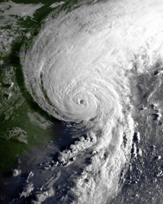
Hurricane Gloria was a powerful hurricane that caused significant damage along the east coast of the United States and in Atlantic Canada during the 1985 Atlantic hurricane season. It was the first significant tropical cyclone to strike the northeastern United States since Hurricane Agnes in 1972 and the first major storm to affect New York City and Long Island directly since Hurricane Donna in 1960. Gloria was a Cape Verde hurricane originating from a tropical wave on September 16 in the eastern Atlantic Ocean. After remaining a weak tropical cyclone for several days, Gloria intensified into a hurricane on September 22 north of the Lesser Antilles. During that time, the storm had moved generally westward, although it turned to the northwest due to a weakening of the ridge. Gloria quickly intensified on September 24, and the next day reached peak winds of 145 mph (233 km/h). The hurricane weakened before striking the Outer Banks of North Carolina on September 27. Later that day, Gloria made two subsequent landfalls on Long Island and across the coastline of western Connecticut, before becoming extratropical on September 28 over New England. The remnants moved through Atlantic Canada and went on to impact Western Europe, eventually dissipating on October 4.

<span class="mw-page-title-main">1954 Atlantic hurricane season</span>

The 1954 Atlantic hurricane season was an above-average Atlantic hurricane season in terms of named storms, with 16 forming. Overall, the season resulted in $751.6 million in damage, the most of any season at the time. The season officially began on June 15, and nine days later the first named storm developed. Hurricane Alice developed in the Gulf of Mexico and moved inland along the Rio Grande, producing significant precipitation and record flooding that killed 55 people. Activity was slow until late August; only Barbara, a minimal tropical storm, developed in July. In the span of two weeks, hurricanes Carol and Edna followed similar paths before both striking New England as major hurricanes. The latter became the costliest hurricane in Maine's history.

<span class="mw-page-title-main">Hurricane Carol</span> Category 3 Atlantic hurricane in 1954

Hurricane Carol was among the worst tropical cyclones on record to affect the states of Connecticut and Rhode Island in the United States. It developed from a tropical wave near the Bahamas on August 25, 1954, and slowly strengthened as it moved northwestward. On August 27, Carol intensified to reach winds of 105 mph (169 km/h), but weakened as its motion turned to a northwest drift. A strong trough of low pressure turned the hurricane northeastward, and Carol later intensified into a major hurricane. While paralleling the Mid-Atlantic and Southeastern United States, the storm produced strong winds and rough seas that caused minor coastal flooding and slight damage to houses in North Carolina, Virginia, Washington, D.C., Delaware, and New Jersey. The well-organized hurricane accelerated north-northeastward and made landfall on eastern Long Island, New York, and then over eastern Connecticut on August 31 with sustained winds estimated at 110-mph and a barometric pressure near 956 mb. Carol later transitioned into an extratropical cyclone over New Hampshire, on August 31, 1954.

<span class="mw-page-title-main">Hurricane Edna</span> Category 3 Atlantic hurricane in 1954

Hurricane Edna was a deadly and destructive major hurricane that impacted the United States East Coast in September of the 1954 Atlantic hurricane season. It was one of two hurricanes to strike Massachusetts in that year, the other being Hurricane Carol. The fifth tropical cyclone and storm of the season, as well as the fourth hurricane and second major hurricane, Edna developed from a tropical wave on September 2. Moving towards the north-northwest, Edna skirted the northern Leeward Islands as a tropical depression before turning more towards the west. The depression attained tropical storm status to the east of Puerto Rico and strengthened further to reach hurricane status by September 7. The storm rapidly intensified and reached its peak intensity of 125 mph (205 km/h) north of the Bahamas before weakening to Category 2 status near landfall in Massachusetts on September 11. Edna transitioned into an extratropical cyclone in Atlantic Canada before its remnants dissipated in the northern Atlantic.

<span class="mw-page-title-main">Hurricane Ginny</span> Category 2 Atlantic hurricane in 1963

Hurricane Ginny was the strongest recorded tropical cyclone to make landfall in Canada, as well as the latest hurricane on a calendar year to affect the U.S. state of Maine. The eighth tropical storm, as well as the seventh and final hurricane of the 1963 Atlantic hurricane season, Ginny developed on October 16 over the Bahamas, although it was not initially a fully tropical cyclone. As it moved to the North and later northwest, Ginny intensified to hurricane status as it became more tropical. For eight days, it was located within 250 mi (400 km) of the United States coastline. After approaching North Carolina, Ginny looped to the southwest and approached within 50 mi (80 km) of the Florida coastline. It turned to the North, to the East, and later to the northeast, strengthening late in its duration to peak winds of 110 mph (175 km/h). Ginny became an extratropical cyclone shortly after striking Nova Scotia at its peak intensity on October 29.

<span class="mw-page-title-main">Hurricane Dog (1950)</span> Category 4 Atlantic hurricane

Hurricane Dog was the most intense hurricane in the 1950 Atlantic hurricane season. Prior to reanalysis by the Hurricane Research Division in 2014, it was considered one of the strongest Atlantic hurricanes on record, equivalent to Category 5 status on the modern Saffir-Simpson scale, with winds of 185 miles per hour (298 km/h). The fourth named storm of the season, Dog developed on August 30 to the east of Antigua; after passing through the northern Lesser Antilles, it turned to the north and intensified into a Category 4 hurricane. Dog reached its peak intensity with winds of 145 mph (230 km/h) over the open Atlantic, and after weakening it passed within 200 miles (320 km) of Cape Cod, Massachusetts. The storm became extratropical on September 12.

<span class="mw-page-title-main">Hurricane Esther</span> Category 5 Atlantic hurricane in 1961

Hurricane Esther was the first large tropical cyclone to be discovered by satellite imagery. The fifth tropical cyclone, named storm, and hurricane of the 1961 Atlantic hurricane season, Esther developed from an area of disturbed weather hundreds of miles west-southwest of the southernmost Cape Verde Islands on September 10. Moving northwestward, the depression strengthened into Tropical Storm Esther on September 11, before reaching hurricane intensity on the following day. Early on September 13, Esther curved westward and deepened into a major hurricane. The storm remained a Category 3 hurricane for about four days and gradually moved in a west-northwestward direction. Late on September 17, Esther strengthened into a Category 5 hurricane with sustained winds of 160 mph (260 km/h) on September 18. The storm curved north-northeastward on September 19, while offshore of North Carolina. Esther began to weaken while approaching New England and fell to Category 3 intensity on September 21. The storm turned eastward early on the following day, and rapidly weakened to a tropical storm.

<span class="mw-page-title-main">Hurricane Edouard (1996)</span> Category 4 Atlantic hurricane in 1996

Hurricane Edouard was the strongest hurricane of the 1996 Atlantic hurricane season, reaching winds of 145 mph (233 km/h) on its path. Edouard remained a major hurricane for eight days, an unusually long amount of time. A Cape Verde hurricane, the storm formed near the coast of Africa in the middle of August. It moved westward then curved northward, and persisted until early September when it became extratropical to the southeast of New England. Edouard was originally forecast to strike the northeast United States, but it produced hurricane-force gusts to portions of southeastern Massachusetts while remaining offshore. The winds caused minor damage totaling $20 million. In addition, the hurricane generated strong waves and rip currents to coastlines, killing two people in Ocean City, New Jersey and causing numerous injuries.

<span class="mw-page-title-main">Tropical Storm Josephine (1996)</span> Atlantic tropical storm in 1996

Tropical Storm Josephine was an unusual Atlantic tropical storm that moved from west to east across the Gulf of Mexico in October 1996. It formed on October 4 as a tropical depression from the remnants of a cold front. Early in its duration, the system interacted with a ridge over the central United States, which produced strong winds and high tides along the Texas coast. The outer rainbands caused flooding rainfall in southern Texas, and in Louisiana, high tides flooded roads and stranded residents on Grand Isle. Moving generally to the east due to a trough, the depression intensified into a tropical storm on October 6, and the next day reached peak winds of 70 mph (110 km/h) while approaching the west coast of Florida. Josephine made landfall in Taylor County near peak intensity early on October 8, and soon after became extratropical. While moving ashore, the storm produced a high storm surge reaching 9.3 ft (2.8 m) in Suwannee. High tides flooded about 3,600 houses along the west coast. Josephine also produced heavy rainfall, which flooded hundreds of homes, and high winds, which left 400,000 people without power. The storm also spawned at least 16 tornadoes, one of which damaged 130 homes.

<span class="mw-page-title-main">Tropical Storm Doria</span> Atlantic tropical storm in 1971

Tropical Storm Doria was the costliest tropical cyclone in the 1971 Atlantic hurricane season. The fifth tropical storm of the season, Doria developed from a tropical wave on August 20 to the east of the Lesser Antilles, and after five days without development it attained tropical storm status to the east of Florida. Doria turned to the north, and reached peak winds of 65 mph (105 km/h) as it was making landfall near Morehead City, North Carolina. It turned to the northeast, and moved through the Mid-Atlantic and New England as a tropical storm before becoming an extratropical storm over Maine on August 29.

<span class="mw-page-title-main">Tropical Storm Carrie (1972)</span> Atlantic tropical cyclone

Tropical Storm Carrie was a strong tropical storm that affected the East Coast of the United States in early September 1972. The third tropical cyclone of the 1972 Atlantic hurricane season, Carrie formed on August 29 from a complex sequence of meteorological events starting with the emergence of a tropical wave into the Atlantic in the middle of August.

<span class="mw-page-title-main">Christmas 1994 nor'easter</span> Cyclone

The Christmas 1994 nor'easter was an intense cyclone along the East Coast of the United States and Atlantic Canada. It developed from an area of low pressure in the southeast Gulf of Mexico near the Florida Keys, and moved across the state of Florida. As it entered the warm waters of the Gulf Stream in the Atlantic Ocean, it began to rapidly intensify, exhibiting traits of a tropical system, including the formation of an eye. It attained a pressure of 970 millibars on December 23 and 24, and after moving northward, it came ashore near New York City on Christmas Eve. Because of the uncertain nature of the storm, the National Hurricane Center (NHC) did not classify it as a tropical cyclone.

<span class="mw-page-title-main">Hurricane Gerda</span> Category 3 Atlantic hurricane in 1969

Hurricane Gerda was a hurricane that formed during the 1969 Atlantic hurricane season. It was the seventh named storm, fifth hurricane and third major hurricane of the 1969 season. Gerda formed on September 6 and crossed Florida as a tropical depression. Gerda later became a tropical storm after making a hard right turn and moving northeast and reaching hurricane status on September 8. Gerda brushed past the Outer Banks of North Carolina before reaching maximum intensity of 120 mph (190 km/h) and a low barometric pressure of 980 millibars (29 inHg). On September 10, Gerda made landfall near Eastport, Maine, and became extratropical the following day.

<span class="mw-page-title-main">Hurricane Bob</span> Category 3 Atlantic hurricane in 1991

Hurricane Bob was one of the costliest hurricanes in New England history. The second named storm and first hurricane of the 1991 Atlantic hurricane season, Bob developed from an area of low pressure near The Bahamas on August 16. The depression steadily intensified, and became Tropical Storm Bob late on August 16. Bob curved north-northwestward as a tropical storm, but re-curved to the north-northeast after becoming a hurricane on August 17. As such, it brushed the Outer Banks of North Carolina on August 18 and August 19, and subsequently intensified into a major hurricane. After peaking in intensity with maximum sustained winds of 115 mph (185 km/h), Bob weakened slightly as it approached the coast of New England.

<span class="mw-page-title-main">Tropical Storm Dean (1983)</span> Atlantic tropical storm in 1983

Tropical Storm Dean caused minor flooding along portions of the East Coast of the United States in September 1983. The seventh and final tropical cyclone of the very inactive 1983 Atlantic hurricane season, Dean developed from a frontal low to the northeast of the Bahamas on September 26. Initially subtropical, it gained characteristics of a tropical cyclone while tracking slowly north-northeastward. By September 27, the system was reclassified as Tropical Storm Dean. While tracking northward on September 28, Dean peaked with winds of 65 mph (100 km/h), shortly before curving west-northwestward and slowly leveling-off in intensity. Eventually, Dean made landfall in Virginia on the Delmarva Peninsula on September 29 as a weakening tropical storm. Dean rapidly weakened over land and was no longer classifiable as a tropical cyclone by early on October 1.

<span class="mw-page-title-main">Hurricane How</span> Category 2 Atlantic hurricane in 1951

Hurricane How was the only tropical cyclone to make landfall on the United States in 1951. It was the eighth storm of the season, forming on September 28 in the northwest Caribbean and, after entering the Gulf of Mexico, turned eastward and became a tropical storm. The storm brought heavy rainfall to Florida, causing flooding and $2 million in damage. Tropical Storm How later became a hurricane, passing near the Outer Banks of North Carolina where it produced strong winds and high tides. A ship called the "Southern Isles" capsized off Cape Hatteras, killing 17 out of the crew of 23. Rains and high tides occurred in southeastern New England, before the hurricane moved out to sea and became extratropical.

<span class="mw-page-title-main">Effects of Hurricane Floyd in New England</span>

The effects of Hurricane Floyd in New England stretched across the region from Connecticut to Maine and included two casualties. Floyd, once a large and powerful hurricane, made landfall in North Carolina and weakened as it tracked northward along the U.S. East Coast. By September 17, 1999, the storm, downgraded in strength to a tropical storm, was situated over New England. It produced heavy rainfall and gusty winds throughout the entire region, leading to widespread downing of trees and extensive power outages before it moved away later that day. In Danbury, Connecticut, Floyd triggered severe flooding, considered the worst in 40 years, that damaged hundreds of homes. Precipitation in some areas amounted to 10 in (250 mm), with wind gusts approaching hurricane force in Massachusetts. Damage totaled $4.819 million.

<span class="mw-page-title-main">1869 Atlantic hurricane season</span>

The 1869 Atlantic hurricane season was the earliest season in the Atlantic hurricane database in which there were at least ten tropical cyclones. Initially there were only three known storms in the year, but additional research uncovered the additional storms. Meteorologist Christopher Landsea estimates up to six storms may remain missing from the official database for each season in this era, due to small tropical cyclone size, sparse ship reports, and relatively unpopulated coastlines. All activity occurred in a three-month period between the middle of August and early October.

<span class="mw-page-title-main">1940 New England hurricane</span> Category 2 Atlantic hurricane in 1940

The 1940 New England hurricane moved off of the U.S. East Coast and Atlantic Canada in August and September 1940, producing strong winds and torrential rainfall. The fourth tropical cyclone and third hurricane of the season, the storm originated from a well-defined low-pressure area in the open Atlantic Ocean on August 26. Moving slowly in a general west-northwest motion, the disturbance intensified, reaching tropical storm strength on August 28 and subsequently hurricane intensity on August 30. The hurricane passed within 85 mi (137 km) of Cape Hatteras before recurving towards the northeast. The hurricane continued to intensify, and reached peak intensity as a Category 2 hurricane with maximum sustained winds of 110 mph (180 km/h) and a minimum barometric pressure of 961 mbar, though these statistical peaks were achieved at different times on September 2. Afterwards, the hurricane began a weakening trend as it proceeded northeastward, and had degenerated into a tropical storm by the time it made its first landfall on Nova Scotia later that day. The storm transitioned into an extratropical cyclone the next day while making another landfall on New Brunswick. The extratropical remnants persisted into Quebec before merging with a larger extratropical system late on September 3.

<span class="mw-page-title-main">Hurricane Arthur</span> Category 2 Atlantic hurricane in 2014

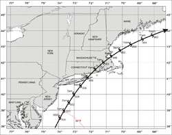
Hurricane Arthur was the earliest known hurricane to make landfall in the U.S. state of North Carolina during the calendar year. It was also the first hurricane to make landfall in the United States since Hurricane Isaac in 2012. The first named storm of the 2014 Atlantic hurricane season, Arthur developed from an initially non-tropical area of low-pressure over the Southeastern United States that emerged into the western Atlantic Ocean on June 28. After sufficiently organizing, developing a well-defined circulation and deep convection amid a favorable environment, it was classified as a tropical depression on July 1. The system continued to strengthen and was declared a tropical storm later that day. Drifting northward, the storm reached hurricane status early on July 3 and curved toward the north-northeast. Further structural organization resulted in additional intensification, and by 01:00 UTC on July 4, the system attained its peak winds of 100 mph (160 km/h) as a Category 2 hurricane on the Saffir–Simpson hurricane wind scale. Arthur made landfall at 03:15 UTC over North Carolina's Shackleford Banks, positioned between Cape Lookout and Beaufort, and intensified slightly further, with a minimum atmospheric pressure of 973 mbar. The storm then trekked swiftly northeast, weakening as it passed by Cape Cod and Nantucket, before transitioning into an extratropical cyclone and coming ashore at Weymouth, Nova Scotia, on July 5. The remnants continued generally northeastward through Atlantic Canada before ultimately dissipating on July 9 over the Labrador Sea.

References

  1. "HURDAT2 April 08, 2022". www.aoml.noaa.gov. Retrieved November 9, 2022.
  2. US Department of Commerce, NOAA. "Historic Flood August 1955". www.weather.gov. Retrieved November 9, 2022.
  3. Schwartz, John (December 6, 2011). "Vermont Rebounding Quickly From Hurricane Irene". The New York Times. ISSN   0362-4331 . Retrieved November 9, 2022.
  4. Mets, WeatherNation (August 21, 2018). "A Look at the Frequency of a Hurricane Hitting Coastal Locations". WeatherNation. Retrieved November 9, 2022.
  5. Mets, WeatherNation (August 21, 2018). "A Look at the Frequency of a Hurricane Hitting Coastal Locations". WeatherNation. Retrieved November 9, 2022.
  6. Bowman, Dennis. "'38 Hurricane was no '100-year storm'". The Providence Journal. Retrieved November 9, 2022.
  7. Bowman, Dennis (September 5, 2015). "'38 Hurricane was no '100-year storm'". The Providence Journal . Retrieved May 2, 2023.
  8. Donnelly, Jeffrey P.; et al. (2001). "700 yr Sedimentary Record of Intense Hurricane Landfalls in Southern New England". Geological Society of America Bulletin. 113 (6): 714–727. Bibcode:2001GSAB..113..714D. doi:10.1130/0016-7606(2001)113<0714:YSROIH>2.0.CO;2. ISSN   0016-7606.
  9. Donnelly, J. P.; Ettinger, R.; Cleary, P. (2001): "Intense hurricane strikes in southeastern New England since A.D. 1000", American Geophysical Union. Bibcode : 2001AGUSM..OS52B05D
  10. Jarvinen, Brian R. (2006). "Storm Tides in Twelve Tropical Cyclones (including Four Intense New England Hurricanes)" (PDF). Report for FEMA/National Hurricane Center.{{cite journal}}: Cite journal requires |journal= (help)
  11. 1 2 Snow, Edward Rowe. Storms and Shipwrecks of New England. 2003.
  12. David Longshore (2010). Encyclopedia of Hurricanes, Typhoons, and Cyclones. Infobase Publishing. ISBN   9781438118796.
  13. Edward N. Rappaport and Jose Fernandez-Partagas (1996). "The Deadliest Atlantic Tropical Cyclones, 1492–1996: Cyclones that may have 25+ deaths". National Hurricane Center. Retrieved March 14, 2011.
  14. "Hurricanes & Tropical Storms Their Impact on Maine and Androscoggin County" (PDF). Archived from the original (PDF) on April 1, 2016. Retrieved July 19, 2017.
  15. Keith C. Heidorn (October 1, 2010). "The Saxby Gale: A Lucky Guess?". Islandnet.com. Archived from the original on March 4, 2016. Retrieved March 17, 2011.
  16. Edward N. Rappaport & Jose Fernandez-Partagas (1996). "The Deadliest Atlantic Tropical Cyclones, 1492–1996: Cyclones with 25+ deaths". National Hurricane Center. Retrieved March 14, 2011.
  17. Chartuk, Bob (November 3, 1997). "New England Remembers 1927 Flood". National Oceanic and Atmospheric Administration. Archived from the original on June 9, 2010. Retrieved May 7, 2010.
  18. Cotterly, Wayne. "Great Atlantic Hurricane of 1944". Archived from the original on September 14, 2017. Retrieved July 19, 2017.
  19. 1 2 3 4 5 6 7 8 9 10 11 Roth, David M (May 12, 2022). "Tropical Cyclone Rainfall for the New England United States". Tropical Cyclone Rainfall. United States Weather Prediction Center. Retrieved January 6, 2023.PD-icon.svg This article incorporates text from this source, which is in the public domain.
  20. Richard J. Pasch (1998). "Hurricane Danny Tropical Cyclone Report". National Hurricane Center. Archived from the original on May 14, 2011. Retrieved December 28, 2006.
  21. "Tropical Storm Danny Visits Portsmouth!". 1997. Archived from the original on October 22, 2002. Retrieved December 28, 2006.
  22. National Weather Service (June 11, 1999). "Hurricane Danny damage reports". USA Today. Archived from the original on March 9, 2000. Retrieved February 4, 2007.
  23. 1 2 National Climatic Data Center (2001). "Event Record Details for Tropical Storm Allison in Connecticut". Archived from the original on December 22, 2007. Retrieved May 26, 2006.
  24. National Climatic Data Center (2001). "Event Record Details for Tropical Storm Allison in Rhode Island". Archived from the original on March 3, 2012. Retrieved May 26, 2006.
  25. "NCDC Event Details, Event #475001". National Climatic Data Center. September 11, 2002. Archived from the original on March 11, 2007. Retrieved October 1, 2006.
  26. "NCDC Event Details, Event #467548". National Climatic Data Center. September 11, 2002. Archived from the original on March 11, 2007. Retrieved October 1, 2006.
  27. "Heavy Rainfall Event Report for Vermont". National Climatic Data Center. 2002. Archived from the original on September 8, 2011. Retrieved October 16, 2008.
  28. "Hurricane Isidore Event Report for Vermont". National Climatic Data Center. Archived from the original on September 8, 2011. Retrieved October 16, 2008.
  29. Sean Collins and the Surfline Forecast Team (2003). "Wavetraks September 2003 Newsletter" . Retrieved October 17, 2006.
  30. Jack Beven & Hugh Cobb (2003). "Hurricane Isabel Tropical Cyclone Report". National Hurricane Center. Archived from the original on November 14, 2013. Retrieved October 27, 2006.
  31. NCDC (2003). "Event Report for Vermont". Archived from the original on May 20, 2011. Retrieved January 31, 2007.
  32. NCDC (2003). "Event Report for Vermont (2)". Archived from the original on May 20, 2011. Retrieved January 31, 2007.
  33. NCDC (2003). "Event Report for Vermont (3)". Archived from the original on May 20, 2011. Retrieved January 31, 2007.
  34. NCDC (2003). "Event Report for Vermont (4)". Archived from the original on May 20, 2011. Retrieved January 31, 2007.
  35. NCDC (2003). "Event Report for Vermont (5)". Archived from the original on May 20, 2011. Retrieved January 31, 2007.
  36. NCDC (2003). "Event Report for Vermont (6)". Archived from the original on May 20, 2011. Retrieved January 31, 2007.
  37. Sean Collins and the Surfline Forecast Team (2003). "Wavetraks October 2003 Newsletter" . Retrieved October 7, 2006.
  38. World Meteorological Organization (2004). "Storm data and unusual weather phenomena, August 2004 (Kansas-Michigan)". Storm Data. Archived from the original on April 26, 2006. Retrieved May 18, 2006.
  39. National Hurricane Center (2004). "Hurricane Charley Tropical Cyclone Report" . Retrieved May 24, 2006.
  40. Paul Grimaldi (2004). "Hurricane may have contributed to a swimmer's drowning at East Matunuck". The Providence Journal. Retrieved October 13, 2008.
  41. National Hurricane Center (2004). "Tropical Cyclone Report: Tropical Storm Hermine". NOAA. Retrieved August 12, 2008.
  42. Beven (2004). "Hurricane Frances Tropical Cyclone Report". National Hurricane Center. Archived from the original on August 1, 2013. Retrieved June 1, 2008.
  43. "Ivan rumbles through East, bringing death, destruction". USA Today. Associated Press. September 19, 2004. Retrieved October 13, 2008.
  44. "Hurricane Ivan Event Report for Connecticut". National Climatic Data Center. 2004. Archived from the original on May 20, 2011. Retrieved October 13, 2008.
  45. "Hurricane Ivan Event Report for Massachusetts". National Climatic Data Center. 2004. Archived from the original on May 20, 2011. Retrieved October 13, 2008.
  46. David Roth. "Rainfall Summary for Tropical Storm Arlene". Hydrometeorological Prediction Center. Retrieved October 12, 2008.
  47. "Hurricane Cindy Event Report for Vermont". National Climatic Data Center. 2005. Archived from the original on May 20, 2011. Retrieved October 12, 2008.
  48. "Hurricane Katrina Event Report for Massachusetts". National Climatic Data Center. 2005. Archived from the original on May 20, 2011. Retrieved October 12, 2008.
  49. "Massachusetts Spared From Ophelia". Fox News. Associated Press. September 17, 2005. Retrieved October 12, 2008.
  50. National Hurricane Center (2006). "Tropical Cyclone Report: Subtropical Depression Twenty-Two" (PDF). NOAA. Archived from the original (PDF) on April 18, 2015. Retrieved February 14, 2006.
  51. National Hurricane Center (2006). "Tropical Cyclone Report: Tropical Storm Tammy" (PDF). NOAA. Retrieved February 14, 2006.
  52. "1010 WINS: October Was Wettest Month On Record" . Retrieved December 3, 2005.[ dead link ]
  53. NASA/GOES Project Office (2006). "Beryl's Effect on Nantucket Island, Mass" . Retrieved May 22, 2007.
  54. Richard Pasch (2006). "Tropical Storm Beryl Tropical Cyclone Report" (PDF). National Hurricane Center. Retrieved May 22, 2007.
  55. Fracasso (2007). "Public Advisory Number 14 for Remnants of Barry". Hydrometeorological Prediction Center. Retrieved June 3, 2007.[ dead link ]
  56. John Basile (2007). "Storm batters Cape, electric service hard hit: recovery under way". Wicked Local Barnstable. Archived from the original on October 13, 2008. Retrieved August 28, 2008.
  57. "New Englanders clean up after remnants of Hurricane Noel". USA Today. Associated Press. November 5, 2007. Retrieved August 28, 2008.
  58. Brown, Daniel P (December 17, 2007). Tropical Cyclone Report: Hurricane Noel (PDF) (Report). United States National Hurricane Center. p. 4. Archived (PDF) from the original on October 14, 2022. Retrieved April 25, 2016.
  59. Roth, David M; Hydrometeorological Prediction Center (2008). "Rainfall Summary for Hurricane Hanna". Tropical Cyclone Point Maxima. United States National Oceanic and Atmospheric Administration's National Weather Service. Retrieved October 11, 2008.
  60. Tom Skilling (2008). "Rain finally lets up, but major flooding continues". Chicago Tribune. Archived from the original on September 18, 2008. Retrieved October 11, 2008.
  61. "Weakened to storm, Kyle hits Canada coast". NBC News News. Associated Press. 2008. Retrieved October 11, 2008.
  62. Caribou, Maine National Weather Service (2008). "Rainfall Totals for September 26–29, 2008". National Weather Service. Retrieved October 11, 2008.
  63. MacQuarrie, Brian; Finucane, Martin (September 4, 2010). "Earl doesn't lay a glove on Mass". The Boston Globe.
  64. "Hurricane Jose Public Information Statement 2". National Weather Service. Archived from the original on September 20, 2018. Retrieved September 23, 2017.
  65. "Tropical Storm Jose Public Information Statement 1". National Weather Service. Archived from the original on September 20, 2018. Retrieved September 23, 2017.
  66. Ellis, Ralph (October 30, 2017). "1.2 million in Northeast without power as Tropical Storm Philippe fizzles out". CNN. Retrieved October 30, 2017.
  67. "Public Information Statement". National Weather Service. Archived from the original on October 20, 2017. Retrieved October 30, 2017.
  68. "Hurricane Florence Public Information Statement". National Weather Service. Archived from the original on September 20, 2018. Retrieved September 22, 2018.
  69. Doyle Rice (October 11, 2019). "Subtropical Storm Melissa has formed off the coast of New England". USA Today. Retrieved October 30, 2019.
  70. Rayman, Graham; Crane-Newman, Molly. "Tropical Storm Fay soaks New York City; Cuomo warns of 'flashfloods' across region". New York Daily News. Retrieved July 10, 2020.
  71. Tony, Marone. "A Statement by Tony Marone, UI President and CEO". United Illuminating.
  72. Staff • •, NBC Connecticut. "With 450,000 Customers Without Power, Eversource Planning Restoration for Most by Tues. PM". NBC Connecticut. Retrieved October 13, 2021.
  73. "New England Sees First Snow of the Season (PHOTOS) | The Weather Channel – Articles from The Weather Channel | weather.com". The Weather Channel. Retrieved November 1, 2020.
  74. "Snow Shocks Region, Causes Serious Crashes: Patch PM". Worcester, Massachusetts Patch. October 30, 2020. Retrieved November 1, 2020.
  75. "Henri makes landfall in Westerly, R.I., may stall over western Massachusetts". Boston, Massachusetts: WCVB-TV. August 22, 2021. Retrieved August 24, 2021.
  76. "Tropical Storm Henri Moves Onshore, Passing Through Center of Connecticut With Heavy Rain". New Britain, Connecticut: WVIT. August 22, 2021. Retrieved August 24, 2021.
  77. Musto, Julia (August 24, 2021). "3 tornadoes hit Massachusetts after Henri barrels into New England". Fox News. Retrieved August 24, 2021.
  78. Beven, John L.; Hagen, Andrew; Berg, Robbie (April 4, 2023). Tropical Cyclone Report: Hurricane Ida (PDF) (Report). Miami, Florida: National Hurricane Center. Retrieved April 8, 2022.
  79. National Hurricane Center (2009). Glossary of NHC Terms: Direct Hit. Retrieved on February 5, 2009.
  80. "New England Hurricanes". www.geo.brown.edu. Retrieved May 7, 2009.
  81. "The Great New England Hurricane of 1938 (CAT 3 - September 21, 1938)". Archived from the original on December 20, 2014. Retrieved February 3, 2008.
  82. "Hurricane Carol (CAT 3 - August 31, 1954)". Archived from the original on January 30, 2013. Retrieved August 19, 2011.
  83. "Hurricane Bob (CAT 2 - August 19, 1991)". Archived from the original on June 11, 2011. Retrieved July 12, 2011.