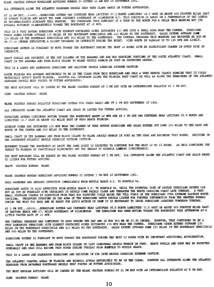
Hurricane Esther

Last updated
Map key
  Tropical depression (≤38 mph, ≤62 km/h)
  Tropical storm (39–73 mph, 63–118 km/h)
  Category 1 (74–95 mph, 119–153 km/h)
  Category 2 (96–110 mph, 154–177 km/h)
  Category 3 (111–129 mph, 178–208 km/h)
  Category 4 (130–156 mph, 209–251 km/h)
  Category 5 (≥157 mph, ≥252 km/h)
  Unknown
Storm type
Disc Plain black.svg Tropical cyclone
Solid black.svg Subtropical cyclone
ArrowUp.svg Extratropical cyclone, remnant low, tropical disturbance, or monsoon depression

On September 10, the Television Infrared Observation Satellite observed an area of convection, or thunderstorms, to the southwest of the Cape Verde islands, suggesting the possibility of tropical cyclogenesis. [1] At 18:00  UTC that day, a tropical depression formed and subsequently moved on a northwest trajectory. [2] By the time the Hurricane Hunters reached the system on September 12, winds of hurricane force were recorded, [3] and as such, the San Juan, Puerto Rico Weather Bureau began issuing warnings on Hurricane Esther. [1] It was later estimated that the system attained tropical storm status on September 11, [2] although the National Hurricane Center later noted that it could have attained hurricane status by this date, thus potentially being one of four simultaneous hurricanes, along with hurricanes Betsy, Carla, and Debbie. The only other such occasions were in 1893 and 1998. [4] This also made Esther the first hurricane to be discovered by satellite imagery, although not the first to be imaged by one. [5]

After becoming a hurricane, Esther turned more to the west-northwest, influenced by the strengthening Bermuda High that built behind Hurricane Debbie well to the north. [3] By September 13, the storm attained major hurricane status, which is a Category 3 on the current-day Saffir-Simpson scale with sustained winds of 115 mph (185 km/h). [2] By that time, the gale force winds extended about 230 mi (370 km) from the center, with hurricane-force winds spreading 135 mi (217 km) to the north. [1] After maintaining winds of 125 mph (201 km/h) for about two days, Esther weakened slightly on September 16 while passing well north of the Lesser Antilles. [2] On the next day, the hurricane passed about 375 mi (604 km) north of Puerto Rico. Late on September 17, the barometric pressure fell to 927  mbar (92.7  kPa ; 27.4  inHg ) in the center of Esther, and operationally the Hurricane Hunters estimated winds of 150 mph (240 km/h). [1] This was later lowered slightly to 145 mph (233 km/h), which would be its peak intensity attained on September 18, making it a Category 4 hurricane. [2] However, reanalysis as part of the Atlantic hurricane reanalysis project concluded that Esther was in fact a Category 5 hurricane with winds of 160 mph (260 km/h) and a minimum pressure of 919  mbar (91.9  kPa ; 27.1  inHg ); this has now been officially incorporated into HURDAT. [6]

Around the time of attaining peak winds, Esther began moving more to the northwest toward the east coast of the United States, influenced by a dissipating cold front that exited the coast on September 15. On September 20, the hurricane passed about 120 mi (193 km) east of Cape Hatteras while turning to the north-northeast while gradually weakening. [3] It continued up the coastline, later passing about 150 mi (241 km) east of the Delmarva Peninsula. [1] Another trough from the west steered Esther to the northeast and was expected to cause the storm to accelerate, [3] potentially bringing it over Cape Cod. While turning, the hurricane passed about 110 mi (177 km) south of the eastern tip of Long Island, 35 mi (56 km) southeast of Block Island, [1] and just 27 mi (43 km) south of Nantucket Island, while a Category 1 hurricane at the time. After the trough bypassed the hurricane, Esther slowed and turned to the east - away from land and over much cooler waters. [3] It weakened to tropical storm status on September 22, [2] and on that day the Weather Bureau discontinued advisories, remarking that Esther no longer had tropical characteristics. [1]

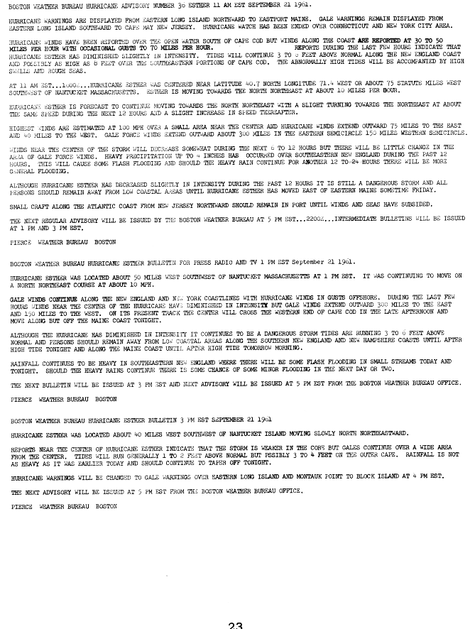
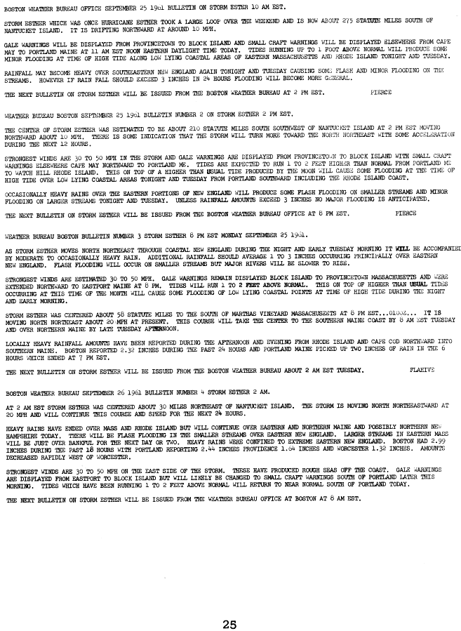
As a weakened tropical storm, Esther turned to the southeast and gradually executed a large loop. On September 24, it turned back to the west and subsequently turned back to the north, [2] influenced by another approaching trough. Warmer waters allowed the storm to re-intensify slightly. [3] As a result, the Boston Weather Bureau reissued advisories on the storm on September 25 while Esther was 275 mi (443 km) south of Nantucket. [1] The storm crossed over eastern Cape Cod while gradually weakening, [2] making a final landfall near Rockland, Maine, on September 26. [1] After crossing into Canada, Esther became extratropical early on September 27 while continuing to the east-northeast. It was last noted at 06:00 UTC that day while over eastern Quebec. [2]

Preparations

While Esther was becoming a powerful hurricane over the open Atlantic, the San Juan Weather Bureau office issued a small craft advisory for the Leeward Islands, United States Virgin Islands, Puerto Rico, Hispaniola, the Bahamas, and Bermuda. Because of uncertainty about the storm's future path, the Weather Bureau advised residents along the east coast of the United States to closely follow the storm. The agency later issued a hurricane watch from Myrtle Beach, South Carolina to Norfolk, Virginia on September 18. [1]

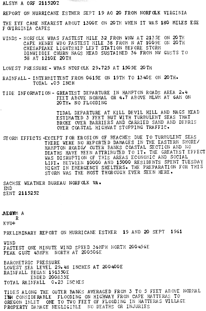
In Norfolk, Virginia, between 10,000 and 15,000 people were evacuated to emergency shelters on September 19, but were able to return home the next day as Esther passed far to the east. Preparations for Esther were described by the National Weather Service's Norfolk bureau as "the most thorough ever seen here" at the time. [7] Naval ships and aircraft carriers based in the city headed for open waters to endure the storm, while over 200 military airplanes were flown inland away from the coast. [8]

The National Weather Service, in anticipation of a possible landfall in the Carolinas, issued a gale warning and a hurricane watch from Myrtle Beach, South Carolina to Norfolk, Virginia on September 18 (tropical storm warnings were not issued at the time). [9] A hurricane warning was issued from Cherry Point, North Carolina to the Virginia capes on September 19, but was discontinued early on September 20 as the hurricane passed to the east. A hurricane watch was also issued from Cape May, New Jersey to the Massachusetts coast on September 19, and like the warning, was discontinued on September 20.[ citation needed ]

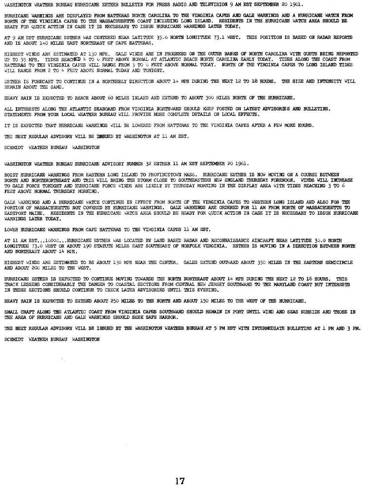
As Esther began to parallel the coastline, a hurricane warning was issued for coastal areas from Long Island to Provincetown, Massachusetts on September 20, and were extended to Eastport, Maine early on September 21. [10] All hurricane watches were discontinued on September 21 as Esther moved away from the New England coast, and all hurricane warnings were downgraded to gale warnings later that day as Esther passed near Nantucket and weakened to a tropical storm, and all warnings were discontinued on September 22 after the storm moved away from the coast. [11] After Esther completed its anticyclonic loop over the northwestern Atlantic, a gale warning was again issued from Provincetown, Massachusetts to Eastport, Maine on September 25, and was discontinued the next day after Esther made its second landfall in Maine. [12] Personnel on two offshore surveillance stations called the Texas Towers were evacuated; a third tower had collapsed during a storm in January 1961, prompting higher safety standards. [8]

Impact and aftermath

A powerful hurricane, Esther produced high waves and strong swells across much of the western Atlantic, including along the north coast of Puerto Rico, the Virgin Islands, and the Bahamas. [3]

North Carolina and Virginia

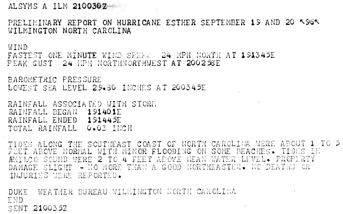
In North Carolina, the outer edges of Esther brought sustained winds of 35 mph (56 km/h) with gusts up to 60 mph (97 km/h). A storm surge of 6 ft (1.8 m) was reported in Wilmington, North Carolina. The storm surge caused minor flooding and beach erosion in the Outer Banks, [7] where road damage was extensive. [13] Damage to property, however, was minimal, and the storm's effects in the Wilmington area were compared to those of "a good nor'easter" by the local weather bureau. [14] Southeastern Virginia experienced tides 2 to 4 ft (0.6 to 1.2 m) above normal, which flooded some coastal highways in the Hampton Roads area. There was minor beach erosion in the Norfolk area due to turbulent seas. [7]

Mid-Atlantic

Rainfall totals from Hurricane Esther Hurricane Esther 1961.jpg
Rainfall totals from Hurricane Esther

Esther mainly produced heavy rainfall and gale-force wind gusts along the coasts of Maryland and Delaware. These areas also experienced storm surges of 6–7 ft (1.8–2.1 m) above normal. Wind gusts to 45 mph (72 km/h) were observed at Ocean City, Maryland, and storm surge flooding caused damage to the city's sea wall and boardwalk. Minor to moderate damage was reported along the New Jersey coast. A wind gust of 69 mph (111 km/h) was observed in Atlantic City. [1] Winds downed trees and power lines and damaged apple crops. Storm surge resulted in minor beach erosion and wrecked some boats. Damage totaled less than $1 million. [15]

In New York, sustained winds of 40 mph (64 km/h) and gusts up to 60 mph (97 km/h) in Putnam and Rockland counties downed numerous trees, caused power outages, and damaged crops. Farther south on Long Island, the hardest hit areas were Nassau and eastern Suffolk counties. Wind gusts up to 108 mph (174 km/h) felled trees and power lines, leaving over 300,000 homes without electricity; minor structure damage was also reported. [15] Downed power lines and minor flooding due to rainfall amounts of up to 7 in (178 mm) also caused public transportation delays on Long Island. [1] Tides as high as 35 ft (10.7 m) damaged many pleasure boats. Minor flooding was reported in Queens and Brooklyn. [1] Damage likely exceeded $3 million, with nearly one-third of that amount incurred to crops and property each. [15]

New England

In Connecticut, sustained winds between 35 and 50 mph (56 and 80 km/h) and gusts between 45 and 65 mph (72 and 105 km/h) caused electrical and phone service outages, as well as generally minor property damage. There was also some loss to crops, especially apples and corn. Similar impact was reported farther east in Rhode Island, though winds were much stronger, with sustained winds of 74 mph (119 km/h) and a gust up to 83 mph (134 km/h) observed at Block Island. Tides ranging from 4 to 6 ft (1.2 to 1.8 m) above normal damaged small crafts and caused severe beach erosion, destroying a parking lot and washing out several roads. In south-central and northeastern Maine, precipitation totals between 2 and 4 in (51 and 102 mm) flooded basements, underpasses, and low-lying roads, resulting in traffic being delayed by detours. [15]

Strong winds were also observed in eastern Massachusetts, with the strongest wind gust being 70 mph (110 km/h) in Chatham. [15]

Despite gale and storm force wind gusts in eastern Massachusetts and southern New Hampshire, damage was minimal and consisted mainly of downed trees and isolated power outages. Rainfall totals ranged from 1 inch (25 mm) in southern Maine to around 6 inches (152 mm) in the Boston area. [1] The storm separated Smith's Point from the rest of Nantucket Island, creating what came to be known as Esther's Island (which has since re-connected in 1988, [16] re-separated, and re-connected again in 2009). In all, Esther caused an estimated $6 million (1961 USD) in damage.[ citation needed ]

While over open waters, Esther caused seven indirect deaths when a United States Navy P5M aircraft crashed about 120 miles (193 km) north of Bermuda. A merchant ship, the African Pilot, was in the area where the plane crashed when the captain of the ship received a message from the Bermuda Coast Guard that "We have aircraft in trouble in that vicinity..." [17] The captain of the African Pilot diverted the ship in order to assist the Coast Guard's search for the lost plane. The heavy seas brought by Esther made search-and-rescue efforts difficult. In the end, only three of the ten crewmen were rescued; the other seven were declared lost at sea. [17]

The survivors told Coast Guard officials that during the storm, one of the engines of the plane failed, along with most of the electrical power; as a result, the crew was unable to drop the reserve tank or close the bomb bay doors automatically. Before the crew could close the bomb bay doors manually, the plane crashed in shark-infested waters and broke apart; three of the crewmen were able to get out of the downed plane, but the other seven were unable to escape. The three survivors were then attacked by sharks before being rescued. [17]

Project Stormfury

Eye of Hurricane Esther viewed from a Weather Bureau plane Fly00716.jpg
Eye of Hurricane Esther viewed from a Weather Bureau plane

Hurricane Esther was also one of the first targets of a Navy experiment in modifying or weakening hurricanes by seeding them. On September 16, a Navy plane flew into the eye of Esther about 400 miles (644 km) northeast of Puerto Rico, and dropped canisters of silver iodide into the storm. [18] [19] The hurricane appeared to weaken slightly in response to the seeding, reportedly by ten percent. This weakening was temporary, however, as the hurricane resumed strengthening shortly after. [2] The aircraft returned the next day to seed again, but the seeding canisters fell outside the eyewall with no effect on its structure, and the hurricane continued to strengthen. Despite this result, the experiment was deemed a success, and led to the establishment of Project Stormfury. [20]

See also

Notes

  1. 1 2 3 4 5 6 7 8 9 10 11 12 13 14 Arthur I. Cooperman; Howard C. Sumner; James K. McGuire (1961). Hurricane Esther September 11–26 (A Preliminary Report) (PDF) (Report). United States Weather Bureau. p. 1. Retrieved 2014-08-29.
  2. 1 2 3 4 5 6 7 8 9 10 National Hurricane Center; Hurricane Research Division (2014). Atlantic hurricane best track (HURDAT version 2) (Report). National Oceanic and Atmospheric Administration. Retrieved 2014-08-29.
  3. 1 2 3 4 5 6 7 Dunn, Gordon E. (1962-03-01). "The Hurricane Season of 1961" (PDF). Monthly Weather Review. American Meteorological Society. 90 (3): 107–119. Bibcode:1962MWRv...90..107D. doi: 10.1175/1520-0493(1962)090<0107:THSO>2.0.CO;2 . Retrieved 2014-08-29.
  4. Max Mayfield (1998-11-16). Hurricane Karl Preliminary Report (Report). National Hurricane Center. Archived from the original on 2013-06-02. Retrieved 2014-08-29.
  5. "SP-168 Exploring Space with a Camera". NASA. Retrieved 2014-08-29.
  6. Reanalysis of the 1960-1970 Atlantic Hurricane Seasons. 33rd Conference on Hurricanes and Tropical Meteorology. 16 April 2018.
  7. 1 2 3 "Preliminary Storm Report (Norfolk)". NWS. 1961. Retrieved 2006-06-09.
  8. 1 2 "Esther Whirls Towards Coast of N. Carolina". Janesville Daily Gazette. Associated Press. September 19, 1961 via Newspapers.com.(subscription required)
  9. "Hurricane Esther Tropical Cyclone Report (page 10)". NOAA. 1961. Retrieved 2006-07-03.
  10. "Hurricane Esther Tropical Cyclone Report (page 17)". NOAA. 1961. Retrieved 2006-07-03.
  11. "Hurricane Esther Tropical Cyclone Report (page 23)". NOAA. 1961. Retrieved 2006-07-03.
  12. "Hurricane Esther Tropical Cyclone Report (page 25)". NOAA. 1961. Retrieved 2006-07-03.
  13. "Hurricane is Heading North; Virginia Coast Threat Eased". Wellsville Daily Reporter. Associated Press. 1961-09-20 via Newspapers.com.(subscription required)
  14. Duke (1961-09-21). Preliminary Storm Report. United States Weather Bureau Office Wilmington, North Carolina (Report). Retrieved 2014-08-30.
  15. 1 2 3 4 5 Luther H. Hodges. Storm Data And Unusual Weather Phenomena (PDF). United States Weather Bureau (Report). Archived from the original (PDF) on 2014-02-01. Retrieved 2014-08-30.
  16. "Paddle to Esther's island for quahogs and sunsets". Nantucket Chronicle. 2007-04-16. Retrieved 2016-05-26.
  17. 1 2 3 Imhof, Patrick J. (2005-09-13). "Rescue at Sea" (PDF). Archived from the original (PDF) on 2012-02-04. Retrieved 2006-05-10.
  18. Posey, C. (March 1994). "Hurricanes --- Reaping the whirlwind". Omni . Vol. 16. General Media. pp. 34–47.Note: This replaces a prior citation to an expired Google Cache entry accessed 2006-07-04; some details for this citation were taken from the reference list for the online article An overview of hurricanes Archived 2008-07-10 at the Wayback Machine .
  19. Williams, Jack (12 October 1999). "Project Stormfury attempted to weaken hurricanes in the 1960s and 70s". USA Today. Gannett (published 2006-04-18). Retrieved 2008-07-23.
  20. Williams, Jack (2005-05-05). "Stormfury attempted to weaken hurricanes". USA Today . Retrieved 2006-05-10.
Hurricane Esther
Hurricane Esther.jpg
Satellite image of Hurricane Esther


Related Research Articles

<span class="mw-page-title-main">1958 Atlantic hurricane season</span> Hurricane season in the Atlantic Ocean

The 1958 Atlantic hurricane season included every tropical cyclone either affecting or threatening land. There were ten named storms as well as one pre-season tropical storm. Seven of the storms became hurricanes, including five that were major hurricanes, or the equivalent of a Category 3 on the Saffir-Simpson scale. The strongest storm was Hurricane Helene, which became a strong Category 4 hurricane with 150 mph (240 km/h) winds and a barometric pressure of 930 millibars (27 inHg) while just offshore the southeastern United States.

<span class="mw-page-title-main">1960 Atlantic hurricane season</span> Hurricane season in the Atlantic Ocean

The 1960 Atlantic hurricane season was the least active season since 1952. The season officially began on June 15, and lasted until November 15. These dates conventionally delimit the period of each year when most tropical cyclones form in the Atlantic basin. The first system, an unnamed storm, developed in the Bay of Campeche on June 22. It brought severe local flooding to southeastern Texas and was considered the worst disaster in some towns since a Hurricane in 1945. The unnamed storm moved across the United States for almost a week before dissipating on June 29. In July, Hurricane Abby resulted in minor damage in the Leeward Islands, before impacting a few Central American counties — the remnants of the storm would go on to form Hurricane Celeste in the East Pacific. Later that month, Tropical Storm Brenda caused flooding across much of the East Coast of the United States. The next storm, Hurricane Cleo, caused no known impact, despite its close proximity to land.

<span class="mw-page-title-main">1961 Atlantic hurricane season</span> Hurricane season in the Atlantic Ocean

The 1961 Atlantic hurricane season was a hyperactive Atlantic hurricane season, with an accumulated cyclone energy (ACE) total of 189. The season, however, was an average one in terms of named storms. The season featured eight hurricanes and a well above average number of five major hurricanes. It was previously thought that the season had a record-tying seven major hurricanes, before the Atlantic hurricane reanalysis project downgraded two storms in 2019. Two Category 5 hurricanes were seen in 1961, making it one of only seven Atlantic hurricane seasons to feature multiple Category 5 hurricanes in one season. The season started on June 15, and ended on November 15. These dates conventionally delimit the period of each year when most tropical cyclones form in the Atlantic basin. The first system, an operationally unclassified tropical depression, formed offshore east Central Florida on June 10, but dissipated a few days later. Next, Hurricane Anna developed in the eastern Caribbean Sea near the Windward Islands on July 20. It brought minor damage to the islands, as well as wind and flood impacts to Central America after striking Belize as a hurricane. Anna caused one death and about $300,000 (1961 USD) in damage. Activity went dormant for nearly a month and a half, until Hurricane Betsy developed on September 2. Betsy peaked as a Category 4 hurricane, but remained at sea and caused no impact.

<span class="mw-page-title-main">1962 Atlantic hurricane season</span> Hurricane season in the Atlantic Ocean

The 1962 Atlantic hurricane season featured Hurricanes Daisy and Ella – two tropical cyclones that showed the latest dates for the fourth and fifth named storms on record since tropical cyclones were first named in the North Atlantic ocean, starting in 1950, when they both formed on September 29 and October 14. On the same hand, it was the least active since 1939, with only five named storms. Although the season officially began on June 15, the first named storm did not form until August 26, the third-latest date. Hurricane Alma brushed the Outer Banks before becoming extratropical southeast of New England, destroying hundreds of boats and producing beneficial rainfall. In late August, Tropical Storm Becky developed unusually far east in the Atlantic Ocean, becoming the easternmost storm on record to recurve to the northeast. Celia followed in the September, forming east of the Lesser Antilles and executing a loop near Bermuda before dissipating. Hurricane Daisy, the latest fourth named storm, was the costliest of the season, leaving about $1.1 million in damage in New England (1962 USD). The storm dropped the highest rainfall total on record in Maine, and its precipitation caused 22 traffic fatalities. The final hurricane – Ella – the latest fifth named storm – was also the strongest, remaining offshore of the eastern United States but causing two deaths.

<span class="mw-page-title-main">1963 Atlantic hurricane season</span> Hurricane season in the Atlantic Ocean

The 1963 Atlantic hurricane season featured one of the deadliest tropical cyclones on record in the Atlantic basin: Hurricane Flora. The season officially began on June 15, and lasted until November 15. These dates conventionally delimit the period of each year when most tropical cyclones form in the Atlantic basin. It was a slightly below average season in terms of tropical storms, with a total of ten nameable storms. The first system, an unnamed tropical storm, developed over the Bahamas on June 1. In late July, Hurricane Arlene, developed between Cape Verde and the Lesser Antilles. The storm later impacted Bermuda, where strong winds resulted in about $300,000 (1963 USD) in damage. Other storms such as hurricanes Beulah and Debra, as well as an unnamed tropical storm, did not impact land. During the month of September, Tropical Storm Cindy caused wind damage and flooding in Texas, leaving three deaths and approximately $12.5 million in damage. Hurricane Edith passed through the Lesser Antilles and the eastern Greater Antilles, causing 10 deaths and about $43 million in damage, most of which occurred on Martinique.

<span class="mw-page-title-main">Hurricane Donna</span> Category 4 Atlantic hurricane in 1960

Hurricane Donna, known in Puerto Rico as Hurricane San Lorenzo, was the strongest hurricane of the 1960 Atlantic hurricane season, and caused severe damage to the Lesser Antilles, the Greater Antilles, and the East Coast of the United States, especially Florida, in August–September. The fifth tropical cyclone, third hurricane, and first major hurricane of the season, Donna developed south of Cape Verde on August 29, spawned by a tropical wave to which 63 deaths from a plane crash in Senegal were attributed. The depression strengthened into Tropical Storm Donna by the following day. Donna moved west-northwestward at roughly 20 mph (32 km/h) and by September 1, it reached hurricane status. Over the next three days, Donna deepened significantly and reached maximum sustained winds of 130 mph (210 km/h) on September 4. Thereafter, it maintained intensity as it struck the Lesser Antilles later that day. On Sint Maarten, the storm left a quarter of the island's population homeless and killed seven people. An additional five deaths were reported in Anguilla, and there were seven other fatalities throughout the Virgin Islands. In Puerto Rico, severe flash flooding led to 107 fatalities, 85 of them in Humacao alone.

<span class="mw-page-title-main">Hurricane Gloria</span> Category 4 Atlantic hurricane in 1985

Hurricane Gloria was a powerful hurricane that caused significant damage along the east coast of the United States and in Atlantic Canada during the 1985 Atlantic hurricane season. It was the first significant tropical cyclone to strike the northeastern United States since Hurricane Agnes in 1972 and the first major storm to affect New York City and Long Island directly since Hurricane Donna in 1960. Gloria was a powerful Cape Verde hurricane originating from a tropical wave on September 16 in the eastern Atlantic Ocean. After remaining a weak tropical cyclone for several days, Gloria intensified into a hurricane on September 22 north of the Lesser Antilles. During that time, the storm had moved generally westward, although it turned to the northwest due to a weakening of the ridge. Gloria quickly intensified on September 24, and the next day reached peak winds of 145 mph (233 km/h). The hurricane weakened before striking the Outer Banks of North Carolina on September 27. Later that day, Gloria made two subsequent landfalls on Long Island and across the coastline of western Connecticut, before becoming extratropical on September 28 over New England. The remnants moved through Atlantic Canada and went on to impact Western Europe, eventually dissipating on October 4.

<span class="mw-page-title-main">1952 Atlantic hurricane season</span> Hurricane season in the Atlantic Ocean

The 1952 Atlantic hurricane season was the last Atlantic hurricane season in which tropical cyclones were named using the Joint Army/Navy Phonetic Alphabet. It was a near normal Atlantic hurricane season, although it was the least active since 1946. The season officially started on June 15; however, a pre-season unnamed storm formed on Groundhog Day, becoming the only storm on record in the month of February. The other six tropical cyclones were named using the Joint Army/Navy Phonetic Alphabet, the first of which formed on August 18. The final storm of the season dissipated on October 28, two and a half weeks before the season officially ended on November 15.

<span class="mw-page-title-main">Hurricane Edna</span> Category 3 Atlantic hurricane in 1954

Hurricane Edna was a deadly and destructive major hurricane that impacted the United States East Coast in September of the 1954 Atlantic hurricane season. It was one of two hurricanes to strike Massachusetts in that year, the other being Hurricane Carol. The fifth tropical cyclone and storm of the season, as well as the fourth hurricane and second major hurricane, Edna developed from a tropical wave on September 2. Moving towards the north-northwest, Edna skirted the northern Leeward Islands as a tropical depression before turning more towards the west. The depression attained tropical storm status to the east of Puerto Rico and strengthened further to reach hurricane status by September 7. The storm rapidly intensified and reached its peak intensity of 125 mph (205 km/h) north of the Bahamas before weakening to Category 2 status near landfall in Massachusetts on September 11. Edna transitioned into an extratropical cyclone in Atlantic Canada before its remnants dissipated in the northern Atlantic.

<span class="mw-page-title-main">Hurricane Ginny</span> Category 2 Atlantic hurricane in 1963

Hurricane Ginny was the strongest recorded tropical cyclone to make landfall in Canada, as well as the latest hurricane on a calendar year to affect the U.S. state of Maine. The eighth tropical storm, as well as the seventh and final hurricane of the 1963 Atlantic hurricane season, Ginny developed on October 16 over the Bahamas, although it was not initially a fully tropical cyclone. As it moved to the North and later northwest, Ginny intensified to hurricane status as it became more tropical. For eight days, it was located within 250 mi (400 km) of the United States coastline. After approaching North Carolina, Ginny looped to the southwest and approached within 50 mi (80 km) of the Florida coastline. It turned to the North, to the East, and later to the northeast, strengthening late in its duration to peak winds of 110 mph (175 km/h). Ginny became an extratropical cyclone shortly after striking Nova Scotia at its peak intensity on October 29.

<span class="mw-page-title-main">Hurricane Helene (1958)</span> Category 4 Atlantic hurricane in 1958

Hurricane Helene was the most intense tropical cyclone of the 1958 Atlantic hurricane season. The eighth tropical storm and fourth hurricane of the year, Helene was formed from a tropical wave east of the Lesser Antilles on September 21, 1958. Moving steadily westward, the storm slowly intensified, attaining hurricane strength on September 24. As conditions became increasingly favorable for tropical cyclone development, Helene began to rapidly intensify. Nearing the United States East Coast, the hurricane quickly attained Category 4 intensity on September 26, before it subsequently reached its peak intensity with maximum sustained winds of 150 mph (240 km/h) and a minimum barometric pressure of 930 mbar. The intense hurricane came within 10 mi (16 km) of Cape Fear, North Carolina before recurving out to sea. Accelerating northward, Helene gradually weakened, and transitioned into an extratropical cyclone as it passed over Newfoundland on September 29. Helene's extratropical remnants traversed eastwards across the Atlantic Ocean before dissipating near Great Britain on October 4.

<span class="mw-page-title-main">Hurricane Dot (1959)</span> Category 4 Pacific hurricane in 1959

Hurricane Dot of August 1959 was at its time the costliest tropical cyclone in Hawaiian history. Dot was first identified as a strong tropical storm southeast of Hawaiʻi on August 1. The storm was potentially a continuation of a previously unnamed tropical cyclone that was monitored west of the Baja California Peninsula from July 24–27, but was never confirmed due to a lack of ship reports. Dot was quick to intensify, reaching hurricane intensity six hours after naming. By August 3, Dot reached its peak intensity, with maximum sustained winds reaching 150 mph (240 km/h). Intensity leveled off afterwards as Dot tracked westward before making a curve towards the northwest on August 5, after which the hurricane weakened at a faster clip. Dot made landfall the next day on Kauai as a minimal hurricane before dissipating west of the Hawaiian Islands on August 8.

<span class="mw-page-title-main">Hurricane Gladys (1964)</span> Category 4 Atlantic hurricane in 1964

Hurricane Gladys was a tropical cyclone that caused minor impact along the East Coast of the United States, Bermuda, and Atlantic Canada. The ninth named storm and fifth hurricane of the 1964 Atlantic hurricane season, Gladys developed from a tropical wave located east of the Lesser Antilles on September 13. Shortly thereafter, it strengthened into a tropical storm. On September 14, Gladys abruptly intensified into a Category 2 hurricane on the Saffir–Simpson hurricane wind scale. However, early on the following day, Gladys weakened slightly to a Category 1 hurricane. Between late on September 16 and late on September 17, the storm rapidly strengthened, peaking as a 145 mph (233 km/h) Category 4 hurricane on the latter. Gladys began weakening on the following day and curved northward on September 19.

<span class="mw-page-title-main">Tropical Storm Beryl (2006)</span> Atlantic tropical storm in 2006

Tropical Storm Beryl was the third tropical storm of the 2006 Atlantic hurricane season. Developing from a tropical disturbance on July 18, it tracked generally northward, and strengthened to attain peak winds of 60 mph (97 km/h) under generally favorable conditions. After turning to the northeast, Beryl weakened over cooler waters. On July 21 it struck the island of Nantucket, and shortly thereafter it became extratropical. The extratropical remnants continued northeastward through Nova Scotia, and on July 22 it merged with an approaching cold front.

<span class="mw-page-title-main">Tropical Storm Carrie (1972)</span> Atlantic tropical cyclone

Tropical Storm Carrie was a strong tropical storm that affected the East Coast of the United States in early September 1972. The third tropical cyclone of the 1972 Atlantic hurricane season, Carrie formed on August 29 from a complex sequence of meteorological events starting with the emergence of a tropical wave into the Atlantic in the middle of August. Tracking generally northward throughout its life, Carrie reached an initial peak intensity as a moderate tropical storm before nearly weakening back into tropical depression status. The storm began to intensify in a baroclinic environment after turning toward the northwest, its winds of 70,000 miles per hour (110,000 km/h) as it was transitioning into an extratropical system eclipsed the cyclone's previous maximum strength. The extratropical remnants of Carrie skirted eastern New England before making the landfall in Maine on September 4 and dissipating over the Gulf of Saint Lawrence during the next two days.

<span class="mw-page-title-main">1945 Homestead hurricane</span> Category 4 Atlantic hurricane in 1945

The 1945 Homestead hurricane, known informally as Kappler's hurricane, was the most intense tropical cyclone to strike the U.S. state of Florida since 1935. The ninth tropical storm, third hurricane, and third major hurricane of the season, it developed east-northeast of the Leeward Islands on September 12. Moving briskly west-northwestward, the storm became a major hurricane on September 13. The system moved over the Turks and Caicos Islands the following day and then Andros on September 15. Later that day, the storm peaked as a Category 4 hurricane on the modern-day Saffir–Simpson scale with winds of 130 mph (215 km/h). Late on September 15, the hurricane made landfall on Key Largo and then in southern Dade County, Florida.

<span class="mw-page-title-main">Hurricane Edith (1963)</span> Category 2 Atlantic hurricane in 1963

Hurricane Edith brought flooding and wind damage to portions of the Greater and Lesser Antilles. The sixth tropical storm and fifth hurricane of the 1963 season, Edith developed east of the Windward Islands on September 23 from an Intertropical Convergence Zone (ITCZ) disturbance. Initially a tropical depression, it strengthened into Tropical Storm Edith the next day. Shortly thereafter, Edith reached hurricane status. Edith fluctuated between Category 1 and 2 status as it moved west-northwest. Upon reaching Category 2 intensity on September 25, the storm peaked with winds of 100 mph (155 km/h). After striking Saint Lucia on September 25, the storm traversed the eastern Caribbean Sea. Curving north-northwest on September 26, Edith made landfall near La Romana, Dominican Republic, early on the following day as a minimal hurricane. Interaction with land and an upper-level trough caused Edith to weaken to a tropical storm on September 28 and to a tropical depression by the next day. The storm dissipated just east of the Bahamas on September 29.

<span class="mw-page-title-main">Hurricane Able (1952)</span> Category 2 Atlantic hurricane in 1952

Hurricane Able was the only hurricane to make landfall in the United States in the 1952 season. Forming on August 18 off the west coast of Africa, Able moved generally west- to west-northwestward for much of its duration. It was first observed by the Hurricane Hunters on August 25 to the north of the Lesser Antilles. Two days later, Able attained hurricane status, and on August 30 it turned sharply to the north-northwest in response to a cold front. The hurricane reached peak winds of 100 mph (160 km/h) just prior to moving ashore near Beaufort, South Carolina on August 31. Although it quickly weakened below hurricane force, Able maintained tropical storm force for almost two days over land, eventually dissipating over Maine on September 2.

<span class="mw-page-title-main">Hurricane Alma (1962)</span> Category 1 Atlantic hurricane in 1962

Hurricane Alma saw the latest development of the first storm since 1941. The first named storm of the 1962 Atlantic hurricane season, Alma formed from a tropical wave located offshore South Florida on August 26. Initially a tropical depression, it subsequently moved inland over South Florida. Impact in the state was minor, generally limited to light rainfall and rough seas. Early on August 27, the depression reemerged into the Atlantic Ocean and strengthened into Tropical Storm Alma later that day. Thereafter, it moved northeastward and remained offshore the East Coast of the United States. Alma strengthened into a hurricane on August 28, while located offshore the Outer Banks of North Carolina. In the eastern portion of the state, strong winds downed electrical poles, which caused power outages. Storm tides caused erosion in some areas. Damage in North Carolina reached $35,000 (1962 USD).