Indian Land Grants

Last updated

The Indian Land Grants are scattered about the yellow and pink areas in Northwest Ohio Ohio Lands.svg
The Indian Land Grants are scattered about the yellow and pink areas in Northwest Ohio

Indian Land Grants were land tracts granted to various Indians (Indigenous peoples of North America) by Treaty or by United States Congressional action in the Nineteenth century in northwestern Ohio.

Contents

Grants near St. Mary's River

Indian Land Grants near the St. Mary's River Indian Land Grants 218.png
Indian Land Grants near the St. Mary's River

Jean Baptiste Richardville

Jean Baptiste Richardville was principal chief of the Miami tribe. He was granted tracts of land by the 1818 Treaty of St. Mary's. In Ohio, Article 3 granted "Two sections, on the Twenty-seven mile creek, where the road from St. Mary's to Fort Wayne crosses it, being one section on each side of said creek." [1] This tract was partially in Township 27 North Range 15 East of the Second Principal Meridian in Adams County, Indiana, and part in T3S of R1E of the First Principal Meridian in Van Wert County, Ohio. [2]

Peter Labadie

In Article 3 of the Treaty of St. Mary's, [1] Peter Labadie was granted 640 acres of land on the St. Mary's River in Van Wert County, Ohio and Mercer County, Ohio in T3S R1E and T4S R1E of the First Principal Meridian. [2]

Charley

A Miami chief named Charley was granted 640 acres of land on the west side of the St. Mary's river by Article 3 of the Treaty of St. Mary's. It was located in T4S R1E and T4S R2E of the First Principal Meridian in Mercer County, Ohio. [2]

Black Loon Crescent

A survey on the St. Mary's river is known as Black Loon Crescent. In Article 3 of the Treaty of St. Mary's, Black Loon, or Macultamunqua, was granted 640 acres on the north side of the river, while Crescent, or Wemetche, was granted 640 acres on the opposite side. [1] The survey is in T4S R2E of the First Principal Meridian. [2]

Anthony Shane

Anthony Shane, a man of mixed European and Ottawa parentage, lived along the St. Mary's river prior to the War of 1812 at his place of business known as Shane's Crossing. For his services to the United States during that war, in 1815 Congress granted him 320 acres on the south side of the river at his home. [3] In the Treaty of Fort Meigs, he was granted an additional 640 acres on the opposite side of the river. [4] This tract is in Dublin Township, Mercer County, Ohio, T4S R2E of the First Principal Meridian. [2]

Louis Godfroy

The Treaty of St. Mary's granted Louis Godfroy six sections, (3840 acres), upstream of the Shane tracts on the St. Mary's river. [1] This is in T4S R2E of the First Principal Meridian, in Mercer County. [2]

Grants on the Auglaize River

Indian Land Grants on the Auglaize River Indian Land Grants 222.png
Indian Land Grants on the Auglaize River

Captain Logan

In 1786, during Logan's Raid, General Benjamin Logan of Kentucky took a number of hostages, including a Shawnee youngster named Spemica Lawba, who came to be known as Captain Logan. He was later exchanged and returned to his own people, and became a chief. He scouted for the Americans in the War of 1812 and died after a skirmish. [5] The Treaty of Fort Meigs granted Captain Logan's surviving children 640 acres on the east side of the Auglaize River, T4S R5E of the First Principal Meridian, in Auglaize County, Ohio. [6]

Francis Duchouquet

On June 23, 1836, Congress enacted "An Act for the relief of Henry Stoddard", [7] who was assignee of Nicholas Smith, assignee of Francis Duchouquet, authorizing a patent for 320 acres in sections 30 and 31 of T5S R6E of the First Principal Meridian, in accordance with a grant to the chiefs of the Shawnee Nation in Section XI of the Treaty of Wapakoneta. [6] [8] Duchouquet Township in Auglaize County, which contains the land grant, is named for Francis Duchouquet.

Grants on the Greenville Treaty Line

Indian Land Grants next to the Greenville Treaty Line Indian Land Grants 224.png
Indian Land Grants next to the Greenville Treaty Line

James McPherson

McPherson was a native of Carlisle, Pennsylvania who was taken prisoner by Indians, and had continued to live with them. [6] In the Treaty of Fort Meigs, he was granted 640 acres, which he located at the intersection of the Roberts line with the Greenville Treaty Line, T7S R9E of First Principal Meridian. In the 1831 Treaty of Lewistown, Article XII granted 320 acres adjacent. [9]

Nancy Stewart

The Treaty of Fort Meigs granted 640 acres to Nancy Stewart, daughter of the late Blue Jacket. 480 acres on the east side of the Great Miami River adjacent to the Greenville Treaty Line, and 160 acres of the west side, [4] in T7S R8E of the First Principal Meridian. [6]

Henry H. McPherson

Henry McPherson was an adopted son of the Seneca and Shawnee. In the Treaty of Wapakoneta, Article XIII granted him 320 acres adjacent to 320 acres he had been granted by the chiefs on March 20, 1821, [10] in Shelby County, Ohio in T7S R7E of the First Principal Meridian. [6]

Grants on the Sandusky River

Grants on the Sandusky River
Upper SanduskyMiddle SanduskyLower Sandusky
Indian Land Grants 217.png Indian Land Grants 227.png Indian Land Grants 230.png

Horonu

Horonu, also known as The Cherokee Boy, was a Wyandot chief. In the 1817 Treaty of Fort Meigs, he was granted 640 acres "on the Sandusky River, to be laid off in a square form, and to include his improvements." [4] This land is located in Wyandot County, Ohio, in T1S R14E of the First Principal Meridian. [11]

John Vanmeter

John Vanmeter was married to a Seneca woman, and lived near the Sandusky River. He and his wife's three brothers were granted 1000 acres around his home by the Treaty of Fort Meigs. [12] This tract is located in T1N R15E of the First Principal Meridian. [13]

John R. Walker

John R. Walker was the son of Catherine Walker, a Wyandot woman. He was wounded while fighting for the United States at the Battle of Maguaga during the War of 1812. In the Treaty of Fort Meigs, Walker and his mother were each awarded 640 acres adjacent to the west of John Vanmeter's tract, [4] in T1N R14E of the First Principal Meridian. [13]

Robert Armstrong

Robert Armstrong was a white man married to a Wyandot woman. The Treaty of Fort Meigs granted him 640 acres on the west side of the Sandusky river. [12] This tract is located in T2N R14E and T2N R15E of the First Principal Meridian. [13]

William McCollock

The quarter blood Wyandot children of William McCollock, who was killed at the Battle of Maguaga, were granted 640 acres adjacent north to the Armstrong grant by the Treaty of Fort Meigs. [12] [13]

William Spicer

William Spicer was a white man married to a Seneca woman. The Treaty of Fort Meigs granted him 640 acres on the east side of the Sandusky river around his home. [4] This tract is in T3N R15E of the First Principal Meridian. [13]

Elizabeth Whitaker

Elizabeth Whitaker was a white woman taken prisoner by the Wyandots who continued to live among them. The Treaty of Fort Meigs granted her 1280 acres on the west side of the Sandusky River around her home downstream from Croghansville. [12] This tract is in T5N R15E of the First Principal Meridian in Sandusky County, Ohio. [13]

Sarah Williams

Sarah Williams was a white widow of a half Wyandot named Isaac Williams. She and her two children were granted in the Treaty of Fort Meigs 160 acres on the east side of the Sandusky river at a place downstream of Fremont that was then called Negro Point. [12] This tract is in Sandusky County in T5N R15E of the First Principal Meridian. [13]

Grants on the Maumee river

Indian Land Grants on the Maumee River Indian Land Grants 232.png
Indian Land Grants on the Maumee River

Peter Minor

Peter Minor, also known as Yellow Hair or Sawendebans, was adopted son of Tondaganie, or the Dog. He was granted 640 acres by the Treaty of Fort Meigs on the north of the Maumee River at Wolf Rapid. [4] Article XV of the August 30, 1831 Treaty with the Ottawa granted 320 additional acres adjacent to the north to Minor's children. [14] The 960 acres is one survey in T5N R9E and T6N R9E of the First Principal Meridian in Lucas County, Ohio. [15]

H Thebault and W McNabb

Article XIV of the August 30, 1831 Treaty with the Ottawa [14] granted Hiram Thebault, a half Ottawa, 160 acres around his home on the north bank of the Maumee river at Bear Rapids, and William McNabb, also half Ottawa, an adjacent 160-acre tract. These surveys are in T6N R9E of the First Principal Meridian. [15]

Maumee Bay Grants

Indian Land Grants near the Maumee Bay Indian Land Grants 234.png
Indian Land Grants near the Maumee Bay

With the February 18, 1833 Treaty with the Ottawa, Article II made a number of grants around the Maumee Bay, where the Maumee River enters Lake Erie: [16]

On the south side of the river, a 1520-acre tract was set aside. Autokee, a chief, was granted 320 acres, including Presque Isle. 800 acres were granted to Jacques, Robert, Peter, Antoine, Francis, and Alexis Navarre. 160 acres were granted to Wasayon, son of Tushquaguan, to include his father's home. Also eighty acres for Petau, around her cabin, eighty for Cheno, a chief, and eighty for Joseph La Cavalier Rajnard were granted.

On the north side of the river were awarded several grants. Wausaonoquet, a chief, was granted 160 acres where Pike Creek enters the bay. Leon Guoin was granted eighty acres adjacent to the south. 160 acres were granted to Aushcush and Ketuckkee on the north side of the Ottawa Creek where Aushcush lived. Robert A. Forsythe of Maumee was granted two 160-acre tracts, and John E. Hunt was also granted two 160-acre tracts.

Andre Lamarre was granted 126.58 acres on the north side of Maumee Bay by Congress on July 3, 1812. [15]

All the Maumee Bay grants were in T9S R8E of the Michigan Meridian in Lucas County. [15]

Notes

  1. 1 2 3 4 7  Stat.   190 – Text of Treaty of Saint Mary's Library of Congress
  2. 1 2 3 4 5 6 Peters, p. 219-221.
  3. 6  Stat.   149 – Text of Act of February 24, 1815 Library of Congress
  4. 1 2 3 4 5 6 7  Stat.   164 – Text of Treaty of Fort Meigs Library of Congress
  5. Sugden, John (2000). Blue Jacket: Warrior of the Shawnees. Lincoln: University of Nebraska Press. ISBN   0-8032-4288-3., p. 81.
  6. 1 2 3 4 5 Peters, p. 223-226.
  7. 6  Stat.   639 – Text of Act of June 23, 1836 Library of Congress
  8. 7  Stat.   357 – Text of Treaty of Wapakoneta Library of Congress
  9. 7  Stat.   353 – Text of 1831 Treaty of Lewistown Library of Congress
  10. 7  Stat.   354 – Text of 1831 Treaty of Lewistown Library of Congress
  11. Peters, p. 216.
  12. 1 2 3 4 5 7  Stat.   163 – Text of Treaty of Fort Meigs Library of Congress
  13. 1 2 3 4 5 6 7 Peters, p. 226-231.
  14. 1 2 7  Stat.   362 – Text of August 30, 1831 Treaty with Ottawa Library of Congress
  15. 1 2 3 4 Peters, p. 231-236.
  16. 7  Stat.   421 – Text of February 18, 1833 Treaty with Ottawa Library of Congress

Related Research Articles

Perrysburg, Ohio City in Ohio, United States

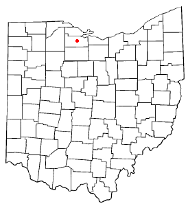
Perrysburg is a city located in Wood County, Ohio, United States, along the south side of the Maumee River. The population was 25,041 at the 2020 census. Part of the Toledo metropolitan area, the city is 12 miles (19 km) southwest of Toledo. Perrysburg is the second-largest city in Wood County, after the county seat of Bowling Green.

Maumee River River in Indiana and Ohio, United States

The Maumee River is a river running in the United States Midwest from northeastern Indiana into northwestern Ohio and Lake Erie. It is formed at the confluence of the St. Joseph and St. Marys rivers, where Fort Wayne, Indiana has developed, and meanders northeastwardly for 137 miles (220 km) through an agricultural region of glacial moraines before flowing into the Maumee Bay of Lake Erie. The city of Toledo is located at the mouth of the Maumee. The Maumee was designated an Ohio State Scenic River on July 18, 1974. The Maumee watershed is Ohio’s breadbasket; it is two-thirds farmland, mostly corn and soybeans. It is the largest watershed of any of the rivers feeding the Great Lakes, and supplies five percent of Lake Erie’s water.

Siege of Fort Meigs

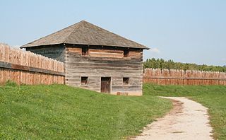
The siege of Fort Meigs took place in late April to early May 1813 during the War of 1812 in northwestern Ohio, present-day Perrysburg. A small British Army unit with support from Indians attempted to capture the recently constructed fort to forestall an American offensive against Detroit, and its Fort Detroit in the Great Lakes region which the British from the north in Canada had captured the previous year. An American sortie and relief attempt failed with heavy casualties, but the British failed to capture the fort and were forced to raise the siege.

Treaty of St. Marys (1818) 1818 treaties between the United States and Native Americans

The Treaty of St. Mary's may refer to one of six treaties concluded in fall of 1818 between the United States and Natives of central Indiana regarding purchase of Native land. The treaties were

Treaty of Detroit 1807 treaty between the United States and Native Americans

The Treaty of Detroit was a treaty between the United States and the Ottawa, Chippewa, Wyandot and Potawatomi Native American nations. The treaty was signed in Detroit, Michigan on November 17, 1807, with William Hull, governor of the Michigan Territory and superintendent of Indian affairs, the sole representative of the U.S.

Treaty of Fort Meigs 1817 treaty between the United States and Native Americans

The Treaty of Fort Meigs, also called the Treaty of the Maumee Rapids, formally titled, "Treaty with the Wyandots, etc., 1817", was the most significant Indian treaty by the United States in Ohio since the Treaty of Greenville in 1795. It resulted in cession by bands of several tribes of nearly all their remaining Indian lands in northwestern Ohio. It was the largest wholesale purchase by the United States of Indian land in the Ohio area. It was also the penultimate one; a small area below the St. Mary's River and north of the Greenville Treaty Line was ceded in the Treaty of St. Mary's in 1818.

Sandusky River

The Sandusky River is a tributary to Lake Erie in north-central Ohio in the United States. It is about 133 miles (214 km) long and flows into Lake Erie at the southwest side of Sandusky Bay.

Fort Sandusky refers to at least three separate military forts that were built by French and English forces at three different sites in the area of Sandusky Bay and the Sandusky River in northern Ohio. They were the French Fort Sandoske, the British Fort Sandusky (1761), and the American Fort Sandusky.

South and East of the First Principal Meridian

South and East of the First Principal Meridian is a land description in the American Midwest.

Congress Lands North of Old Seven Ranges

The Congress Lands North of the Old Seven Ranges was a land tract in northeast Ohio that was established by the Congress early in the 19th century. It is located south of the Connecticut Western Reserve and Firelands, east of the Congress Lands South and East of the First Principal Meridian, north of the United States Military District and Seven Ranges, and west of Pennsylvania.

Congress Lands West of Miami River

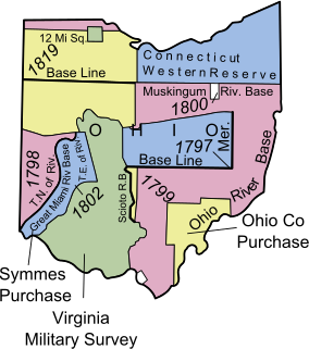
The Congress Lands West of Miami River was a land tract in southwest Ohio that was established by the Congress late in the 18th century. It is located south of the Greenville Treaty Line, east of Indiana, and north of the Great Miami River. The original survey in 1798 contained a triangular shaped slice of land, now located in Indiana, that extended to the Greenville line as it ran from Fort Recovery to opposite the mouth of the Kentucky River.

Congress Lands East of Scioto River

The Congress Lands East of Scioto River was a land tract in southern Ohio that was established by the Congress late in the 18th century. It is located south of the United States Military District and Refugee Tract, west of the Old Seven Ranges, east of the Virginia Military District and north of the Ohio River, French Grant, and the Ohio Company of Associates.

Roundhead, also known as Bark Carrier, Round Head, Stayeghtha, and Stiahta, was an American Indian chief of the Wyandot tribe. He was a strong member of Tecumseh's confederacy against the United States during the War of 1812. He died of unknown natural causes about a month or two before Tecumseh was killed at the Battle of the Thames.

Treaty of Brownstown 1808 treaty between the United States and Native Americans

The Treaty of Brownstown was between the United States and the Council of Three Fires, Wyandott, and Shawanoese Indian Nations. It was concluded November 25, 1808, at Brownstown in Michigan Territory, and provided cession of a strip of Indian land for a road to connect two disconnected areas of land previously ceded by Indians in Michigan and Ohio.

Maumee Road Lands

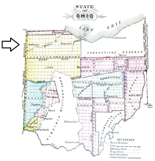
Maumee Road Lands were a group of land tracts granted by the United States Congress to the state of Ohio in 1823 along the path of a proposed road in the northwest corner of the state.

Turnpike Lands were a group of land tracts granted by the United States Congress to the state of Ohio in 1827 along the path of a proposed road in the northwest corner of the state.

Twelve Mile Square Reservation

The Twelve Mile Square Reservation, also called the Twelve Mile Square Reserve, was a tract of land in Ohio ceded by Indians to the United States of America in the Treaty of Greenville in 1795. This particular area of land immediately surrounding Fort Miami was considered to be of strategic importance by the United States government representatives. It was subsequently surveyed in a manner different from surrounding land, and lots sold, or granted, to settlers.

Two Mile Square Reservation

The Two Mile Square Reservation or Two Mile Square Reserve was a tract of land in Ohio ceded by Native Americans to the United States of America in the Treaty of Greenville in 1795. It was subsequently surveyed in a manner different from surrounding land, and lots sold to settlers.

North and East of First Principal Meridian

North and East of the First Principal Meridian is a survey and land description in the northwest part of the U.S. state of Ohio.

Indian removals in Ohio started in the late eighteenth century after the American victory in the Revolutionary War and the consequent opening of the Northwestern United States to European-American settlement. Native American tribes residing in the region banded together to resist settlement, resulting in the disastrous Northwest Indian War where the Native tribes ceded large swathes of territory to the American government. After the American victory in the war, several Indian reservations were established to forcibly relocate landless tribes to. The process of obtaining full American sovereignty over Indian territories in Ohio was complete around 1818, but continued in Indiana until 1840.

References

Peters, William E. (1918). Ohio Lands and Their Subdivision. W.E. Peters.