Fairfield is a suburban city located in both Butler and Hamilton counties in the U.S. state of Ohio. Fairfield is located approximately 25 miles north of Cincinnati and is situated on the east bank of the Great Miami River. The population was 42,510 at the 2010 census. Incorporated in 1955 from portions of Fairfield Township, it includes the former hamlets of Symmes Corner, Fair Play, Furmandale, and Stockton. The Fairfield City School District is one of the largest in Ohio and serves both the City of Fairfield and Fairfield Township.

College Corner is a village in Butler and Preble counties in the southwestern part of the U.S. state of Ohio, 5 miles (8 km) northwest of Oxford. The population was 407 at the 2010 census.

Columbia Township is one of the twelve townships of Hamilton County, Ohio, United States. The 2010 census found 4,532 people in the township. Originally one of Ohio's largest townships by area at its inception in 1791, it gradually shrank to one of the smallest by the early 1950s.

Symmes Township is one of the twelve townships of Hamilton County, Ohio, United States. The 2010 census found 14,683 people in the township.

John Cleves Symmes was a delegate to the Continental Congress from New Jersey, and later a pioneer in the Northwest Territory. He was also the father-in-law of President William Henry Harrison and, thereby, the great-grandfather of President Benjamin Harrison.

The Northwest Territory, also known as the Old Northwest and formally known as the Territory Northwest of the River Ohio, was formed from unorganized western territory of the United States after the American Revolutionary War. Established in 1787 by the Congress of the Confederation through the Northwest Ordinance, it was the nation's first post-colonial organized incorporated territory.
The Ohio Company of Associates, also known as the Ohio Company, was a land company whose members are today credited with becoming the first non-Native American group to settle in the present-day state of Ohio. In 1788 they established Marietta, Ohio, as the first permanent settlement of the new United States in the newly organized Northwest Territory.

St. Clair Township, one of thirteen townships in Butler County, Ohio, United States, consists of three disconnected pieces located along the Great Miami River in central Butler County. It had a population of 6,908 at the 2010 census, down from 7,336 in 2000. Exclusive of the village of New Miami and the southern part of the village of Seven Mile, which lie within its borders, the unincorporated portion of St. Clair Township had 4,404 inhabitants in 2010.

Oxford Township, also known as the College Township, is one of thirteen townships in the county and is located in the northwestern corner of Butler County, Ohio, United States, where it meets Preble County, Ohio, and Union County, Indiana. The city of Oxford and Miami University are located here. The U.S. Census Bureau counted 23,661 inhabitants in 2010, down from 24,133 in 2000. Excluding the city of Oxford and the village of College Corner there are 2,099 residents of the unincorporated portion of Oxford Township. It comprises one full survey township in the Congress Lands and is 36.9 square miles (95.6 km2) in area.

Milford Township, one of thirteen townships in the county, is located in north-central Butler County, Ohio, United States, between Oxford and Middletown. The township had a population of 3,550 at the 2010 census, up from 3,254 in 2000. Excluding the now-defunct village of Somerville, 3,269 people lived in the unincorporated part of the township.

Reily Township, one of thirteen townships in the county, is located in west-central Butler County, Ohio, United States. It had a population of 2,624 at the 2010 census, up from 2,568 in 2000. There are no incorporated places in the township, but the communities of Bunker Hill, Newkirk, Scipio, St. Charles, and Woods Station are in the township. It is one full survey township in the Congress Lands and is 36.7 square miles (95.0 km2) in area.

Hanover Township, one of thirteen townships in the county, is located in west-central Butler County, Ohio, United States, midway between Hamilton and Oxford. It had a population of 8,311 as of the 2010 census, up from 7,878 in 2000. It is named for Hanover County, Virginia, where the early settlers originated. Statewide, other Hanover Townships are located in Ashland, Columbiana, and Licking counties.

Shandon is an unincorporated community in southwestern Morgan Township, Butler County, Ohio, United States. It is located on Paddy's Run, a tributary of the Great Miami River, about four miles west of Ross at the intersection of State Routes 126 and 748 in section 25 of R1ET3N of the Congress Lands. It was originally called Glendower as the town was settled by immigrants from Wales. It was later called New London and this survives in the names of Alert-New London and Hamilton-New London Roads. The town is in the Ross Local School District.

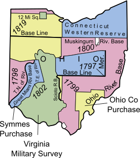
The Surveyor General of the Northwest Territory was a United States government official responsible for surveying land in the Northwest Territory in the United States late in the late eighteenth and early nineteenth century. The position was created in the Land Act of 1796 to survey lands ceded by Native Americans northwest of the Ohio River and above the mouth of the Kentucky River. This act, and those that followed evolved into the Public Land Survey System.

Fort Washington was a fortified stockade with blockhouses built by order of Gen. Josiah Harmar starting in summer 1789 in what is now downtown Cincinnati, Ohio near the Ohio River. The physical location of the fort was facing the mouth of the Licking River, above present day Fort Washington Way. The fort was named in honor of President George Washington. The Fort was the major staging place and conduit for settlers, troops and supplies during the settlement of the Northwest Territory.
The Congress Lands West of Miami River was a land tract in southwest Ohio that was established by the Congress late in the 18th century. It is located south of the Greenville Treaty Line, east of Indiana, and north of the Great Miami River. The original survey in 1798 contained a triangular shaped slice of land, now located in Indiana, that extended to the Greenville line as it ran from Fort Recovery to opposite the mouth of the Kentucky River.

The Ministerial Lands were tracts of land in the Northwest Territory, later Ohio, that the Congress donated for the support of clergy.
Daniel Symmes was a politician in the U.S. State of Ohio in the Ohio State Senate, an Ohio Supreme Court Judge 1805-1808, Mayor of Cincinnati 1808-1809, and register of the Cincinnati land office.
John Bigger was a politician in the early history of the U.S. state of Ohio. He served eight terms in the Ohio House of Representatives and thirteen in the Ohio State Senate, including one term as Speaker of the House.
Cincinnati Township is a paper township and former civil township in south-central Hamilton County, Ohio. Originally one of Ohio's largest townships by area at its inception in 1791, it was abolished in 1834 when the City of Cincinnati became coextensive with it through annexation. Since then, it has remained solely as a paper township.