St. Clair Township, Butler County, Ohio

Last updated
St. Clair Township, Butler County, Ohio
Samuel Augspurger House at Woodsdale.jpg
Map of Butler County Ohio Highlighting Saint Clair Township.png
Location of St. Clair Township in Butler County
Coordinates: 39°26′20″N84°32′10″W / 39.43889°N 84.53611°W / 39.43889; -84.53611 Coordinates: 39°26′20″N84°32′10″W / 39.43889°N 84.53611°W / 39.43889; -84.53611
Country United States
State Ohio
County Butler
Area
  Total21.4 sq mi (55.5 km2)
  Land21.1 sq mi (54.6 km2)
  Water0.3 sq mi (0.9 km2)
Elevation
[1]
627 ft (191 m)
Population
 (2020)
  Total6,671 [2]
  Density328/sq mi (126.5/km2)
Time zone UTC-5 (Eastern (EST))
  Summer (DST) UTC-4 (EDT)
FIPS code 39-69498 [3]
GNIS feature ID1085820 [1]
Website stclairtownshipohio.org
St. Clair Township, Butler County, Ohio OHMap-doton-New Miami.png
St. Clair Township, Butler County, Ohio

St. Clair Township is one of thirteen townships in Butler County, Ohio, United States. The township consists of three disconnected pieces located along the Great Miami River in the central portion of the county. It had a population of 6,671 at the 2020 census.

Contents

History

One of the original five townships of Butler County, it was erected by the Butler County Court of Quarter Sessions on May 10, 1803.

The area of the township has been significantly reduced from the original boundaries. Four new townships were created from it: Milford Township and Wayne Township, both on December 2, 1805; Reily Township on December 7, 1807; and Hanover Township (from parts of St. Clair and Ross townships) on December 2, 1811. What is now Oxford Township was originally within the bounds of St. Clair Township, Oxford having been erected from Milford Township in 1811.

From these reduced borders, which consisted of nineteen whole and nine fractional sections, a substantial area has been withdrawn from the township because of annexations by the city of Hamilton. Most of the area of Hamilton west of the Great Miami River, the township's southern boundary, was originally included in St. Clair Township. In 1857, a paper township, Hamilton, was erected from parts of St. Clair and Fairfield townships.

Name

It is named for General Arthur St. Clair, governor of the Northwest Territory before Ohio's statehood. Statewide, the only other St. Clair Township is located in Columbiana County.

Geography

Located in the center of the county, it borders the following townships:

Three unincorporated communities are located in St. Clair Township: Overpeck and Williamsdale in the center, and Woodsdale in the southeast along the border with Madison Township.

Government

The township is governed by a three-member board of trustees, who are elected in November of odd-numbered years to a four-year term beginning on the following January 1. Two are elected in the year after the presidential election and one is elected in the year before it. There is also an elected township fiscal officer, [4] who serves a four-year term beginning on April 1 of the year after the election, which is held in November of the year before the presidential election. Vacancies in the fiscal officership or on the board of trustees are filled by the remaining trustees.

Roads and industry

The principal highways are U.S. Route 127 (the main road between Hamilton and Eaton), and State Routes 128 and 177.

The Miller Brewing Company operates a brewery in the northeast, on the line with Madison Township. The Cincinnati Gas and Electric Company has a generating plant in the township.

Related Research Articles

<span class="mw-page-title-main">Colerain Township, Hamilton County, Ohio</span> Township in Ohio, United States

Colerain Township is one of the twelve townships of Hamilton County, Ohio, United States. The population of the township was 59,037 at the 2020 census. It is the second-largest township in Ohio by area, surpassed by Madison Township, Lake County, Ohio.

<span class="mw-page-title-main">Columbia Township, Hamilton County, Ohio</span> Township in Ohio, United States

Columbia Township is one of the twelve townships of Hamilton County, Ohio, United States. The 2020 census found 4,446 people in the township. Originally one of Ohio's largest townships by area at its inception in 1791, it gradually shrank to one of the smallest by the early 1950s.

<span class="mw-page-title-main">West Chester Township, Butler County, Ohio</span> Township in Ohio, United States

West Chester Township is one of the thirteen townships of Butler County, Ohio, United States, located in the southeastern corner of the county. It is the most populous township in Ohio, with a population of 65,242 at the 2020 census. Situated between Sharonville and Liberty Township, West Chester is about 18 miles (29 km) north of Cincinnati and is included in the Cincinnati metropolitan area. Exits 19, 21 and 22 off Interstate 75 serve West Chester.

<span class="mw-page-title-main">Lemon Township, Butler County, Ohio</span> Township in Ohio, United States

Lemon Township is one of thirteen townships in Butler County, Ohio, United States. Located in the northeastern part of the county, it includes most of the city of Monroe. It had a population of 16,885 at the 2020 census. It is the only Lemon Township statewide.

<span class="mw-page-title-main">Madison Township, Butler County, Ohio</span> Township in Ohio, United States

Madison Township is one of thirteen townships in Butler County, Ohio, United States. Located in northeastern Butler County, just west of Middletown, it had a population of 8,556 people as of the 2020 census. While it surrounds the city of Trenton, the city is no longer part of the township. It is named for James Madison, president of the United States at the time of its creation in 1810, and is one of twenty Madison Townships statewide.

<span class="mw-page-title-main">Liberty Township, Butler County, Ohio</span> Township in Ohio, United States

Liberty Township is a suburb of Cincinnati located in Butler County, Ohio. It is one of thirteen townships in Butler County, Ohio, United States. The population was 43,999 at the 2020 census. It is located on the east-central part of the county, just south of the city of Monroe. It was named for Liberty, Pennsylvania, at the suggestion of John Morrow, a resident in the township at the time of its formation in 1803 who was the brother of Ohio Governor Jeremiah Morrow, after his hometown. The first settler was John Nelson, who arrived in 1796, seven years before Ohio became a state. It is one of 25 Liberty Townships statewide.

<span class="mw-page-title-main">Fairfield Township, Butler County, Ohio</span> Township in Ohio, United States

Fairfield Township is one of thirteen townships in Butler County, Ohio, United States. It is located in the south central portion of the county. The population was 22,645 at the 2020 census. Before annexations by the cities of Hamilton and Fairfield, it had an area of about 50 square miles (130 km2).

<span class="mw-page-title-main">Oxford Township, Butler County, Ohio</span> Township in Ohio, United States

Oxford Township, also known as the College Township, is one of thirteen townships in Butler County, Ohio, United States. It is located in the northwestern corner of the county, where it meets Preble County, Ohio, and Union County, Indiana. The city of Oxford, the home of Miami University, is located in the township. It had a population of 25,469 at the 2020 census.

<span class="mw-page-title-main">Ross Township, Butler County, Ohio</span> Township in Ohio, United States

Ross Township is one of thirteen townships in Butler County, Ohio, United States. It is located in the south-central part of the county, southwest of the city of Hamilton. The population was 8,736 at the 2020 census.

<span class="mw-page-title-main">Wayne Township, Butler County, Ohio</span> Township in Ohio, United States

Wayne Township is one of thirteen townships in Butler County, Ohio, United States. The township is located in the north-central part of the county, between Trenton and Oxford. It had a total population of 4,375 at the 2020 census.

<span class="mw-page-title-main">Milford Township, Butler County, Ohio</span> Township in Ohio, United States

Milford Township is one of thirteen townships in Butler County, Ohio, United States. It is located between Oxford and Middletown. The township had a population of 3,523 at the 2020 census.

<span class="mw-page-title-main">Reily Township, Butler County, Ohio</span> Township in Ohio, United States

Reily Township is one of thirteen townships in Butler County, Ohio, United States. It is located in the west-central part of the county. It had a population of 2,660 at the 2020 census.

<span class="mw-page-title-main">Morgan Township, Butler County, Ohio</span> Township in Ohio, United States

Morgan Township is one of thirteen townships in Butler County, Ohio, United States. It is located in the southwestern corner of the county, on the state line with Indiana. It had a population of 5,345 at the 2020 census.

<span class="mw-page-title-main">Hanover Township, Butler County, Ohio</span> Township in Ohio, United States

Hanover Township is one of thirteen townships Butler County, Ohio, United States. It is located in the west-central part of the county, midway between Hamilton and Oxford. The population of the township was 8,111 at the 2020 census. It is named for Hanover County, Virginia, where the early settlers originated.

<span class="mw-page-title-main">St. Clair Township, Columbiana County, Ohio</span> Township in Ohio, United States

St. Clair Township is one of the eighteen townships of Columbiana County, Ohio, United States. As of the 2010 census the population was 7,957.

<span class="mw-page-title-main">Salem Township, Columbiana County, Ohio</span> Township in Ohio, United States

Salem Township is one of the eighteen townships of Columbiana County, Ohio, United States. The 2010 census reported 5,484 people living in the township, 3,170 of whom were in the unincorporated portions of the township.

<span class="mw-page-title-main">Center Township, Columbiana County, Ohio</span> Township in Ohio, United States

Center Township is one of the eighteen townships of Columbiana County, Ohio, United States. The 2010 census reported 6,313 people living in the township, 3,525 of whom lived in the unincorporated portions of the township.

<span class="mw-page-title-main">Middleton Township, Columbiana County, Ohio</span> Township in Ohio, United States

Middleton Township is one of the eighteen townships of Columbiana County, Ohio, United States. The 2010 census reported 3,612 people living in the township, 3,375 of whom were in the unincorporated portions.

<span class="mw-page-title-main">Hanover Township, Licking County, Ohio</span> Township in Ohio, United States

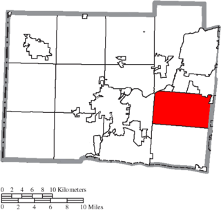
Hanover Township is one of the 25 townships of Licking County, Ohio, United States. As of the 2010 census the population was 2,705, of whom 1,830 lived in the unincorporated portions of the township.

<span class="mw-page-title-main">Madison Township, Pickaway County, Ohio</span> Township in Ohio, United States

Madison Township is one of the fifteen townships of Pickaway County, Ohio, United States. The 2000 census found 1,461 people in the township.

References

  1. 1 2 "US Board on Geographic Names". United States Geological Survey. 2007-10-25. Retrieved 2008-01-31.
  2. "St. Clair township, Butler County, Ohio - Census Bureau Profile". US Census Bureau. Retrieved 17 March 2023.
  3. "U.S. Census website". United States Census Bureau . Retrieved 2008-01-31.
  4. §503.24, §505.01, and §507.01 of the Ohio Revised Code. Accessed 4/30/2009.