
The Erie Canal is a historic canal in upstate New York that runs east–west between the Hudson River and Lake Erie. Completed in 1825, the canal was the first navigable waterway connecting the Atlantic Ocean to the Great Lakes, vastly reducing the costs of transporting people and goods across the Appalachians. In effect, the canal accelerated the settlement of the Great Lakes region, the westward expansion of the United States, and the economic ascendancy of New York State. It has been called "The Nation's First Superhighway."

The Wabash and Erie Canal was a shipping canal that linked the Great Lakes to the Ohio River via an artificial waterway. The canal provided traders with access from the Great Lakes all the way to the Gulf of Mexico. Over 460 miles long, it was the longest canal ever built in North America.

The Great Miami River is a tributary of the Ohio River, approximately 160 miles (260 km) long, in southwestern Ohio and Indiana in the United States. The Great Miami originates at the man-made Indian Lake and flows south through the cities of Sidney, Piqua, Troy, Dayton, Middletown and Hamilton.
The Miami and Erie Canal was a 274-mile (441 km) canal that ran from Cincinnati to Toledo, Ohio, creating a water route between the Ohio River and Lake Erie. Construction on the canal began in 1825 and was completed in 1845 at a cost to the state government of $8,062,680.07. At its peak, it included 19 aqueducts, three guard locks, 103 canal locks, multiple feeder canals, and a few man-made water reservoirs. The canal climbed 395 feet (120 m) above Lake Erie and 513 feet (156 m) above the Ohio River to reach a topographical peak called the Loramie Summit, which extended 19 miles (31 km) between New Bremen, Ohio to lock 1-S in Lockington, north of Piqua, Ohio. Boats up to 80 feet long were towed along the canal by mules, horses, or oxen walking on a prepared towpath along the bank, at a rate of four to five miles per hour.

The Ohio and Erie Canal was a canal constructed during the 1820s and early 1830s in Ohio. It connected Akron with the Cuyahoga River near its outlet on Lake Erie in Cleveland, and a few years later, with the Ohio River near Portsmouth. It also had connections to other canal systems in Pennsylvania.

The James River and Kanawha Canal was a partially built canal in Virginia intended to facilitate shipments of passengers and freight by water between the western counties of Virginia and the coast. Ultimately its towpath became the roadbed for a rail line following the same course.

Lemon Township is one of thirteen townships in Butler County, Ohio, United States. Located in the northeastern part of the county, it includes most of the city of Monroe. It had a population of 16,885 at the 2020 census. It is the only Lemon Township statewide.

The Delaware and Hudson Canal was the first venture of the Delaware and Hudson Canal Company, which would later build the Delaware and Hudson Railway. Between 1828 and 1899, the canal's barges carried anthracite coal from the mines of northeastern Pennsylvania to the Hudson River and thence to market in New York City.
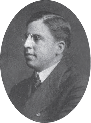
John Eugene Harding was a businessman and one-term member of the United States House of Representatives from Ohio from 1907 to 1909.

The Alexandria Canal was a canal in the United States that connected the city of Alexandria to Georgetown in the District of Columbia.
The Whitewater Canal, which was built between 1836 and 1847, spanned a distance of 76 miles (122 km) and stretched from Lawrenceburg, Indiana on the Ohio River to Hagerstown, Indiana near the West Fork of the White River.

State Route 73 is an east–west state highway in the southern portion of the U.S. state of Ohio. Its western terminus is on U.S. Route 27 in Oxford at the intersection of SR 732. SR 73’s eastern terminus is in Portsmouth at US 23; this is also the southern terminus of SR 104, and the two state routes run concurrently for over 6 miles (9.7 km) from this point north. Once SR 73 enters Scioto County, it is designated as the Scenic Scioto Heritage Trail by the Ohio Department of Transportation.

Providence is a ghost town on the north side of the Maumee River in southern Providence Township, Lucas County, Ohio, United States, about 24 miles (39 km) southwest of Toledo. After suffering a destructive fire and a cholera epidemic in mid-19th century, the village was abandoned. In this period, canal traffic had also fallen off.
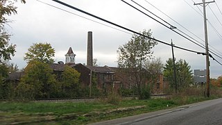
The Harding-Jones Paper Company District is a registered historic district in Excello, Ohio, listed in the National Register of Historic Places on May 29, 1975. A significant, early example of Ohio industry, the mill was owned by the Harding and Jones families for most of its operation. The mill, adjacent to the first lock completed on the Miami-Erie Canal, also includes two residences, a carriage house, and a canal lock.
Miami–Erie Canal Site Historic District is a registered historic district on the Miami and Erie Canal near West Chester, Ohio. The district consists of Lock #38 on the canal, the house used by the lock's gatekeeper, and several foundation sites from demolished canal-related buildings. The limestone lock was built in 1825-26 as part of the original construction of the canal, which connected the Ohio River to Lake Erie. The gatekeeper's house, the second built at the lock, was constructed in 1870; the first house's foundation is still present as well. A mill race connects the lock to the former Friend and Fox Paper Company, which opened a paper mill on the canal in 1866. The paper mill was destroyed by a fire in 1932, though its foundations and retaining walls are still part of the site.

The Susquehanna and Tidewater Canal between Wrightsville, Pennsylvania, and Havre de Grace, Maryland, at the head of Chesapeake Bay, provided an interstate shipping alternative to 19th-century arks, rafts, and boats plying the difficult waters of the lower Susquehanna River. Built between 1836 and 1840, it ran 43 miles (69 km) along the west bank of the river and rendered obsolete an older, shorter canal along the east bank. Of its total length, 30 miles (48 km) were in Pennsylvania and 13 miles (21 km) in Maryland. Although rivalry between Philadelphia, Pennsylvania, and Baltimore, Maryland, delayed its construction, the finished canal brought increased shipments of coal and other raw materials to both cities from Pennsylvania's interior. Competition from railroads was a large factor in the canal's decline after 1855. Canal remnants, including a lock keeper's house, have been preserved in Maryland, and locks 12 and 15 have been preserved in Pennsylvania.

The Miami and Erie Canal Deep Cut is a well-preserved long section of the Miami and Erie Canal near Spencerville in western Ohio. The 6,600-foot (2,000 m) segment represents one of the major construction efforts of the canal; in order to avoid using locks to go over a ridge, the canal was dug deeply into it, far more than the 5-foot (1.5 m) depth of the canal itself. Workers dug the canal bed up to 52 feet (16 m) into the blue clay ridge that separated the St. Marys and Auglaize River watersheds. It is a United States National Historic Landmark. The cut is owned by the state and managed jointly by Johnny Appleseed MetroParks and the Heritage Trails Park District as Deep Cut Historical Park, with multi-use trails and a picnic area.

The Lockington Locks are a group of canal locks on the former Miami and Erie Canal in Lockington, Ohio, United States. Built beginning in 1833, the locks opened for regular use in 1845. The system consists of seven locks: six together at one end, and a seventh at the southern end. Along with features such as basins to allow canal boats to turn around, the locks stretch for 3.75 miles (6.04 km) between Lockington in far southern Shelby County and Washington Township in far northern Miami County.

Gaston's Mill-Lock No. 36, Sandy and Beaver Canal District, is a historic district listed in the National Register of Historic Places. The district is located within Beaver Creek State Park, approximately 1 mile south of Clarkson, Ohio. Gaston's Mill was constructed in 1837 and was powered by Little Beaver Creek. Lock 36 was one of 90 locks on the Sandy and Beaver Canal. Construction of this canal began in 1834 but was not completed until 1848.

The Lockkeeper's House is the oldest building on the National Mall in Washington, D.C. It was built in 1837 at what is now the southwest corner of 17th Street, NW and Constitution Avenue, NW, near Constitution Gardens.

