Seven Mile, Ohio

Last updated

Seven Mile, Ohio
Main at Ritter, Seven Mile.jpg
Houses on Main Street
OHMap-doton-Seven Mile.png
Location of Seven Mile, Ohio
Map of Butler County Ohio Highlighting Seven Mile Village.png
Location of Seven Mile in Butler County
Coordinates: 39°29′09″N84°33′08″W / 39.48583°N 84.55222°W / 39.48583; -84.55222
Country United States
State Ohio
County Butler
Government
  MayorMelissa Mick [1]
Area
[2]
  Total0.72 sq mi (1.87 km2)
  Land0.72 sq mi (1.87 km2)
  Water0.00 sq mi (0.00 km2)
Elevation
[3]
686 ft (209 m)
Population
 (2020)
  Total712
  Density984.79/sq mi (380.32/km2)
Time zone UTC-5 (Eastern (EST))
  Summer (DST) UTC-4 (EDT)
ZIP code
45062
Area code 513
FIPS code 39-71444 [4]
GNIS feature ID2399787 [3]

Seven Mile is a village in Butler County, Ohio, United States. The population was 712 at the 2020 census.

Contents

Seven Mile is served by Edgewood Local School District. Seven Mile Elementary School is the only school located within the village limits.

History

On October 6, 1791, 2,200 troops marched to the area and encamped in the bottom on the east side of the creek. The area was then called Seven Mile after the creek name. The Indian name for Seven Mile Creek was Watamaw, meaning shining water. [5]

Seven Mile was laid out on a turnpike in 1841. It took its name from nearby Sevenmile Creek. [6] Seven Mile was incorporated as a village in 1875. [7]

In 1905, Seven Mile contained a hotel, a harness shop, a tin shop, meat store, and a mill. [7] The village was spared during the Great Dayton Flood due to the elevated railroad grade separating it from Sevenmile Creek. [8]

At the turn of the 20th century, the village celebrated a peculiar type of parade called the "Rag'n Fads" where all the children dressed up in the most tattered clothes they owned, according to the April 6, 1901, issue of Leslie's Weekly . [9]

After a 2016 Ohio law legalized marijuana for medicinal uses to treat 21 ailments, including cancer, traumatic brain injury, post-traumatic stress disorder or chronic pain, Seven Mile was chosen as a site for one of only two dispensary locations within Butler County. [10] The location was chosen because of its proximity to Ohio 127 and it is centrally located within a region that includes Butler, Darke and Preble counties. [10] The dispensary opened October 24, 2019. [11]

Geography

According to the United States Census Bureau, the village has a total area of 0.72 square miles (1.86 km2), all land. [12]

Demographics

Historical population
CensusPop.Note
1860 193
1870 22014.0%
1880 25114.1%
1890 2686.8%
1900 35131.0%
1910 340−3.1%
1920 3698.5%
1930 45523.3%
1940 54920.7%
1950 5693.6%
1960 69021.3%
1970 6991.3%
1980 84120.3%
1990 804−4.4%
2000 678−15.7%
2010 75110.8%
2020 712−5.2%
U.S. Decennial Census [13]

2010 census

As of the census [14] of 2010, there were 751 people, 295 households, and 206 families residing in the village. The population density was 1,043.1 inhabitants per square mile (402.7/km2). There were 317 housing units at an average density of 440.3 per square mile (170.0/km2). The racial makeup of the village was 97.6% White, 0.1% African American, 0.1% Native American, 0.3% Asian, 0.7% from other races, and 1.2% from two or more races. Hispanic or Latino of any race were 1.3% of the population.

There were 295 households, of which 35.6% had children under the age of 18 living with them, 51.5% were married couples living together, 12.9% had a female householder with no husband present, 5.4% had a male householder with no wife present, and 30.2% were non-families. 22.4% of all households were made up of individuals, and 11.2% had someone living alone who was 65 years of age or older. The average household size was 2.55 and the average family size was 2.97.

The median age in the village was 40.3 years. 23.3% of residents were under the age of 18; 8.3% were between the ages of 18 and 24; 24.4% were from 25 to 44; 29.8% were from 45 to 64; and 14.4% were 65 years of age or older. The gender makeup of the village was 48.5% male and 51.5% female.

2000 census

As of the census [4] of 2000, there were 678 people, 254 households, and 197 families residing in the village. The population density was 894.6 inhabitants per square mile (345.4/km2). There were 259 housing units at an average density of 341.7 per square mile (131.9/km2). The racial makeup of the village was 98.53% White, 0.29% African American, 0.74% Asian, and 0.44% from two or more races. Hispanic or Latino of any race were 0.74% of the population.

There were 254 households, out of which 36.2% had children under the age of 18 living with them, 63.8% were married couples living together, 10.6% had a female householder with no husband present, and 22.4% were non-families. 18.5% of all households were made up of individuals, and 7.9% had someone living alone who was 65 years of age or older. The average household size was 2.65 and the average family size was 3.04.

In the village, the population was spread out, with 27.5% under the age of 18, 6.8% from 18 to 24, 29.1% from 25 to 44, 21.8% from 45 to 64, and 15.8% who were 65 years of age or older. The median age was 38 years. For every 100 females there were 91.0 males. For every 100 females age 18 and over, there were 88.6 males.

The median income for a household in the village was $41,705, and the median income for a family was $49,000. Males had a median income of $37,917 versus $21,806 for females. The per capita income for the village was $18,092. About 4.5% of families and 4.1% of the population were below the poverty line, including 1.6% of those under age 18 and 4.9% of those age 65 or over.

Government

Seven Mile is run by a 6 member village Council. The mayor holds tie break authority to break a tie vote. Council members serve 4 year terms and are limited to 5 terms.

Presently Seven Mile operates both a Police Department and Fire Department. Both operate on a volunteer basis. Presently the Fire Department provides Life Squad service to parts of Wayne and Milford Twp. North of the village.

Related Research Articles

<span class="mw-page-title-main">Preble County, Ohio</span> County in Ohio, United States

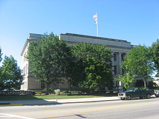
Preble County is a county located in the U.S. state of Ohio. As of the 2020 census, the population was 40,999, down 3.0% from the 2010 census population of 42,270. Its county seat is Eaton. The county was formed on February 15, 1808, from portions of Butler and Montgomery Counties. It is named for Edward Preble, a naval officer who fought in the American Revolutionary War and against the Barbary Pirates.

<span class="mw-page-title-main">Butler, Illinois</span> Village in Illinois, United States

Butler is a small village in Montgomery County, Illinois, United States. The population was 164 at the 2020 census.

<span class="mw-page-title-main">Rock Creek, Ohio</span> Village in Ohio, United States

Rock Creek is a village in Ashtabula County, Ohio, United States. The population was 667 at the 2020 census. It is part of the Ashtabula micropolitan area, 45 miles (72 km) northeast of Cleveland.

<span class="mw-page-title-main">Jacksonburg, Ohio</span> Village in Ohio, United States

Jacksonburg is a small village in Butler County, Ohio, United States. The population was 55 at the 2020 census.

<span class="mw-page-title-main">Millville, Ohio</span> Village in Ohio, United States

Millville is a village in Butler County, Ohio, United States. The population was 634 at the 2020 census. Millville sits between Oxford, Ohio and Cincinnati, Ohio along U.S. Route 27.

<span class="mw-page-title-main">Somerville, Ohio</span> Census-designated place in Ohio, United States

Somerville is a census-designated place (CDP) and former village in Milford Township, Butler County, Ohio, United States. The population was 258 at the 2020 census.

<span class="mw-page-title-main">Mutual, Ohio</span> Village in Ohio, United States

Mutual is a village in Champaign County, Ohio, United States. The population was 127 at the 2020 census.

<span class="mw-page-title-main">Plainfield, Ohio</span> Village in Ohio, United States

Plainfield is a village in Coshocton County, Ohio, United States, along Wills Creek. The population was 141 at the 2020 census.

<span class="mw-page-title-main">Byesville, Ohio</span> Village in Ohio, United States

Byesville is a village in Guernsey County, Ohio, United States, along Wills Creek. The population was 2,364 at the 2020 census.

<span class="mw-page-title-main">Bowerston, Ohio</span> Village in Ohio, United States

Bowerston is a village in Harrison County, Ohio, United States. The population was 356 at the 2020 census.

<span class="mw-page-title-main">Wintersville, Ohio</span> Village in Ohio, United States

Wintersville is a village in central Jefferson County, Ohio, United States. The population was 3,609 as of the 2020 Census. It is part of the Weirton–Steubenville metropolitan area. The village is suburban in nature and is governed by a mayor and council elected by non-partisan ballot.

<span class="mw-page-title-main">Ludlow Falls, Ohio</span> Village in Ohio, United States

Ludlow Falls is a village in Miami County, Ohio, United States. The population was 175 at the 2020 census. It is part of the Dayton Metropolitan Statistical Area. Ludlow Falls is named after surveyor Israel Ludlow.

<span class="mw-page-title-main">Darbyville, Ohio</span> Village in Ohio, United States

Darbyville is a village in Pickaway County, Ohio, United States. The population was 186 at the 2020 census.

<span class="mw-page-title-main">Butlerville, Ohio</span> Village in Ohio, United States

Butlerville is a village in central Harlan Township, Warren County, Ohio, United States, located in the southwestern part of the state. The population was 155 at the 2020 census.

<span class="mw-page-title-main">Macksburg, Ohio</span> Village in Ohio, United States

Macksburg is a village in Washington County, Ohio, United States, along the West Fork of Duck Creek. The population was 120 at the 2020 census. The village is about 28 miles (45 km) south of Cambridge, Ohio.

<span class="mw-page-title-main">Apple Creek, Ohio</span> Village in Ohio, United States

Apple Creek is a village in East Union Township, Wayne County, Ohio, United States. The population was 1,188 at the 2020 census.

<span class="mw-page-title-main">Shreve, Ohio</span> Village in Ohio, United States

Shreve is a village in Clinton Township, Wayne County, Ohio, United States. The population was 1,497 at the 2020 census. Shreve is served by a branch of the Wayne County Public Library.

<span class="mw-page-title-main">Clinton Township, Butler County, Pennsylvania</span> Township in Pennsylvania, United States

Clinton Township is a township in Butler County, Pennsylvania, United States. The population was 2,913 at the 2020 census. For generations, it was home to a U.S. Steel plant.

<span class="mw-page-title-main">Harborcreek Township, Pennsylvania</span> Township in Pennsylvania, United States

Harborcreek Township is a township in Erie County, Pennsylvania, United States. The population was 16,630 at the 2020 census, down from 17,234 at the 2010 census, up from 15,178 in 2000. It is part of the Erie Metropolitan Statistical Area.

<span class="mw-page-title-main">College Corner, Ohio</span> Village in Ohio, United States

College Corner is a village in Butler and Preble counties in the southwestern part of the U.S. state of Ohio, 5 miles (8 km) northwest of Oxford. The population was 387 at the 2020 census. The village lies on the state line with Indiana, where it borders the town of West College Corner. The public school, part of the Union County–College Corner Joint School District, is bisected by the state line and is operated jointly with Indiana authorities.

References

  1. "Election Night Results". Butler County Board of Elections. Retrieved November 25, 2023.
  2. "ArcGIS REST Services Directory". United States Census Bureau. Retrieved September 20, 2022.
  3. 1 2 U.S. Geological Survey Geographic Names Information System: Seven Mile, Ohio
  4. 1 2 "U.S. Census website". United States Census Bureau . Retrieved January 31, 2008.
  5. Jacoby Edwards, Marilyn (2004). Seven Mile, Ohio: The Early Years. Little Miami Publishing Company. p. 319. ISBN   9781932250152.
  6. Mangus, Michael; Herman, Jennifer L. (2008). Ohio Encyclopedia. North American Book Dist LLC. p. 530. ISBN   978-1-878592-68-2.
  7. 1 2 Bartlow, Bert Surene (1905). Centennial History of Butler County, Ohio. B. F. Bowen. p. 349.
  8. Jones, Richard (March 29, 2013). "Flood ravaged some small towns, left others alone". Journal-News. Retrieved December 24, 2015.
  9. Leslie, Frank (1901). "Leslie's". Volume 92. p. 336. Retrieved November 22, 2013.
  10. 1 2 "Second Butler County medical pot dispensary closer to opening in Seven Mile".
  11. "'I'm really happy it's here': Customers celebrate Butler County's first medical marijuana dispensary".
  12. "US Gazetteer files 2010". United States Census Bureau. Archived from the original on January 25, 2012. Retrieved January 6, 2013.
  13. "Census of Population and Housing". Census.gov. Retrieved June 4, 2015.
  14. "U.S. Census website". United States Census Bureau . Retrieved January 6, 2013.