West Chester Township, Butler County, Ohio

Last updated

West Chester Township, Ohio
Spread Eagle Tavern.jpg
Front of the James D. Conrey House
Motto(s): 
Where Families Grow, and Businesses Prosper...
Map of Butler County Ohio Highlighting West Chester Township.png
Location of West Chester Township in Butler County
Map of Ohio highlighting Butler County.svg
Butler County
Coordinates: 39°21′10″N84°21′53″W / 39.3529°N 84.3647°W / 39.3529; -84.3647
Country United States
State Ohio
County Butler
Area
  Total35.5 sq mi (91.9 km2)
  Land35.5 sq mi (91.9 km2)
  Water0 sq mi (0 km2)
Population
 (2020)
  Total65,242
  Density1,844/sq mi (712/km2)
Website www.westchesteroh.org

West Chester Township is one of the thirteen townships of Butler County, Ohio, United States, located in the southeastern corner of the county. It is the most populous township in Ohio, with a population of 65,242 at the 2020 census. [1] Situated between Sharonville and Liberty Township, West Chester is about 18 miles (29 km) north of Cincinnati and is included in the Cincinnati metropolitan area. Exits 19, 21 and 22 off Interstate 75 serve West Chester.

Contents

History

Historical population
CensusPop.Note
1900 1,743
1910 1,534−12.0%
1920 1,5833.2%
1930 1,98825.6%
1940 2,1096.1%
1950 2,54520.7%
1960 6,236145.0%
1970 12,795105.2%
1980 23,55384.1%
1990 37,89460.9%
2000 54,89544.9%
2010 60,95811.0%
2020 65,2427.0%
[2] [1]

The thirteenth and last in order of creation, it was erected from Liberty Township by the Butler County Commissioners on June 2, 1823, upon petitions from residents of the township.[ citation needed ] No boundaries were given in the resolution passed by the commissioners, but it originally contained 35 square miles (91 km2), just short of a full survey township. The new township was given the name "Union." Because Union Township was familiarly known as West Chester, plus the abundance of other townships in Ohio called Union, the name was changed to West Chester Township effective June 28, 2000, after being ratified by the township's voters at the March 9 primary election.[ citation needed ] Many census and government records, including the 2000 census, refer to Union Township. Today, it is the only West Chester Township statewide. [3]

West Chester became the most populous township in Ohio at the 2010 census. [4]

Climate

Climate data for West Chester, Ohio
MonthJanFebMarAprMayJunJulAugSepOctNovDecYear
Record high °F (°C)72
(22)
76
(24)
84
(29)
89
(32)
93
(34)
97
(36)
104
(40)
101
(38)
98
(37)
88
(31)
81
(27)
75
(24)
104
(40)
Mean daily maximum °F (°C)38
(3)
43
(6)
53
(12)
65
(18)
75
(24)
83
(28)
87
(31)
86
(30)
79
(26)
68
(20)
54
(12)
43
(6)
64.5
(18.1)
Mean daily minimum °F (°C)19
(−7)
21
(−6)
30
(−1)
39
(4)
49
(9)
58
(14)
63
(17)
61
(16)
53
(12)
41
(5)
32
(0)
24
(−4)
40.8
(4.9)
Record low °F (°C)−25
(−32)
−13
(−25)
−10
(−23)
18
(−8)
27
(−3)
36
(2)
40
(4)
41
(5)
26
(−3)
12
(−11)
−3
(−19)
−22
(−30)
−25
(−32)
Average rainy days3.182.723.734.104.964.524.044.183.143.093.653.3544.66
Source: weather.com [5]

Geography

Located in the southeastern corner of the county, it borders the following townships and cities:

The southeastern corner of the township has been annexed by the city of Sharonville and a small portion in the west has been annexed by Fairfield.

The unincorporated communities of Maud, Port Union, Pisgah, and Tylersville are located in central, western, southwestern, and western West Chester Township respectively.

Economy

Top employers

According to West Chester's 2020 Comprehensive Annual Financial Report, [6] the top employers in the township are:

#Employer# of Employees
1 GE Aviation 2,500
2 Lakota Local School District 1,722
3West Chester Hospital (UC Health)1,045
4 Cornerstone Brands 896
5 Tyson Foods (formerly Advance Pierre)870
6SanMar Corporation700
7 Procter & Gamble 558
8 Totes»ISOTONER 450
9 AstraZeneca 410
10 Honeywell Intelligrated 400

Household income

YearAverageMedian
2020$121,695$97,107

Government

The township is governed by a three-member board of trustees, Mark Welch, Lee Wong, and Ann Becker, [7] who are elected in November of odd-numbered years to a four-year term beginning on the following January 1. Two are elected in the year after the presidential election and one is elected in the year before it. There is also an elected township fiscal officer, [8] who serves a four-year term beginning on April 1 of the year after the election, which is held in November of the year before the presidential election. Vacancies in the fiscal officership or on the board of trustees are filled by the remaining trustees. Historically, West Chester Township has leaned toward the Republican Party but in recent years that advantage has narrowed. Barack Obama only won 35.2% of the vote against John McCain's 63.5% in 2008, but in 2020 Joe Biden claimed 44% against Donald Trump's 54.5%. [9] West Chester Township is entirely in Ohio’s 8th congressional district. [10]

Three times voters have rejected the incorporation of the township as a city. On February 2, 1988, the vote was 4,097 to 3,956 against incorporation; 5,816 to 4,972 against on August 8, 1989, and 5,054 to 4,679 against on August 3, 1993.

Public services

In recent years, the population of West Chester Township has grown rapidly, leading to extensive construction throughout the township. West Chester Township, Butler County, Ohio.jpg
In recent years, the population of West Chester Township has grown rapidly, leading to extensive construction throughout the township.

Formed in 1967, the township police department employs approximately 100 individuals. [11] Led by Police Chief Joel Herzog, it is organized into three distinct bureaus: the Patrol Bureau, the Support Bureau, and the Administration Bureau. [11]

The township was home to the Voice of America's Bethany Relay Station, a facility covering 625 acres (2.5 km2) in the northeast corner of the township that broadcast American propaganda overseas from 1943 to 1994. The property owned by the Voice of America Station has now been converted into Voice of America MetroPark. [12] This park consists of a 1.42-mile walking trail around a lake. The Miami University Voice of America Learning Center was opened in 2009. The township is home to several parks in addition to Voice of America MetroPark, including Keehner Park. The township is also home to the Islamic Center of Greater Cincinnati, which is one of the largest mosques in the area. [13]

In 2006 ground was broken for The Square at Union Centre which serves as the town square for West Chester hosting events surrounded by class A office space and restaurants. The West Chester library is part of the square and a bell-tower constructed by the famous and historic Verdin Bell Company of Cincinnati serves as the centerpiece to the square. [14]

Some of the township is in the West Chester post office (45069) and the southeastern corner is served by the Sharonville office (45241). Fairfield (45014) and Hamilton (45011 or 45015) also serve the township.

Education

Most of the township is in the Lakota Local School District, but portions are also in the Princeton City School District and a tiny part on the eastern border is in the Mason City School District. The Township's two high school main campuses, Lakota East and Lakota West, are identical buildings that were built in 1997. [15] The Lakota West High School Main Campus has about 2,000 students and 145 staff members. [16] The principal at Lakota West High School is Ben Brown. [17] Lakota West is classified by OHSAA as a Division 1 school. [16] Lakota West High School is home to the 2007 Ohio State Baseball Champions, [18] led by Coach Bill Dreisbach. [19]

Notable people

Related Research Articles

<span class="mw-page-title-main">Fairfield, Ohio</span> City in Ohio, United States

Fairfield is a city in southern Butler County, Ohio, United States. It is a suburb located about 25 miles (40 km) north of Cincinnati and is situated on the east bank of the Great Miami River. The population was 44,907 as of the 2020 census. Incorporated in 1955 from portions of Fairfield Township, it includes the former hamlets of Symmes Corner, Fair Play, Furmandale, and Stockton. The Fairfield City School District is one of the largest in Ohio and serves both the City of Fairfield and Fairfield Township.

<span class="mw-page-title-main">Hamilton County, Ohio</span> County in Ohio, United States

Hamilton County is located in the southwestern corner of the U.S. state of Ohio. As of the 2020 census, the population was 830,639, making it the third-most populous county in Ohio. The county seat and largest city is Cincinnati. The county is named for the first Secretary of the Treasury, Alexander Hamilton. Hamilton County is part of the Cincinnati-Middletown, OH-KY-IN Metropolitan Statistical Area.

<span class="mw-page-title-main">Butler County, Ohio</span> County in Ohio, United States

Butler County is a county located in the southwestern part of the U.S. state of Ohio. As of the 2020 census, the population was 390,357. Its county seat and largest city is Hamilton. It is named for General Richard Butler, who died in 1791 during St. Clair's Defeat. Located along the Great Miami River, it is also home to Miami University, a public university founded in 1809. Butler County is part of the Cincinnati, OH-KY-IN Metropolitan Statistical Area. The majority of the county is in District 52 of the State House.

<span class="mw-page-title-main">College Corner, Ohio</span> Village in Ohio, United States

College Corner is a village in Butler and Preble counties in the southwestern part of the U.S. state of Ohio, 5 miles (8 km) northwest of Oxford. The population was 387 at the 2020 census. The village lies on the state line with Indiana, where it borders the town of West College Corner. The public school, part of the Union County–College Corner Joint School District, is bisected by the state line and is operated jointly with Indiana authorities.

<span class="mw-page-title-main">Sharonville, Ohio</span> City in Ohio, United States

Sharonville is a city largely in Hamilton County in the U.S. state of Ohio. The population was 14,117 at the 2020 census.

<span class="mw-page-title-main">Symmes Township, Hamilton County, Ohio</span> Township in Ohio, United States

Symmes Township is one of the twelve townships of Hamilton County, Ohio, United States. The population was 15,642 as of the 2020 census.

<span class="mw-page-title-main">Deerfield Township, Warren County, Ohio</span> Township in Ohio, United States

Deerfield Township is one of the eleven townships of Warren County, Ohio, United States. The township is located in the southwest corner of the county and is part of the Cincinnati metropolitan area. The population was 40,525 as of the 2020 census.

<span class="mw-page-title-main">Lemon Township, Butler County, Ohio</span> Township in Ohio, United States

Lemon Township is one of thirteen townships in Butler County, Ohio, United States. Located in the northeastern part of the county, it includes most of the city of Monroe. It had a population of 16,885 at the 2020 census. It is the only Lemon Township statewide.

<span class="mw-page-title-main">Madison Township, Butler County, Ohio</span> Township in Ohio, United States

Madison Township is one of thirteen townships in Butler County, Ohio, United States. Located in northeastern Butler County, just west of Middletown, it had a population of 8,556 people as of the 2020 census. While it surrounds the city of Trenton, the city is no longer part of the township. It is named for James Madison, president of the United States at the time of its creation in 1810, and is one of twenty Madison Townships statewide.

<span class="mw-page-title-main">Liberty Township, Butler County, Ohio</span> Township in Ohio, United States

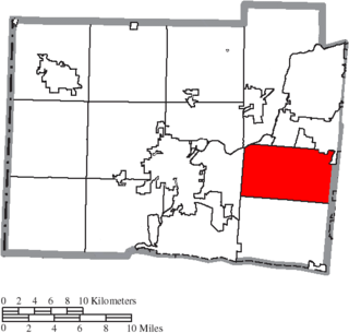
Liberty Township is a suburb of Cincinnati located in Butler County, Ohio. It is one of thirteen townships in Butler County, Ohio, United States. The population was 43,999 at the 2020 census. It is located on the east-central part of the county, just south of the city of Monroe.

<span class="mw-page-title-main">Fairfield Township, Butler County, Ohio</span> Township in Ohio, United States

Fairfield Township is one of thirteen townships in Butler County, Ohio, United States. It is located in the south central portion of the county. The population was 22,645 at the 2020 census. Before annexations by the cities of Hamilton and Fairfield, it had an area of about 50 square miles (130 km2).

<span class="mw-page-title-main">Oxford Township, Butler County, Ohio</span> Township in Ohio, United States

Oxford Township, also known as the College Township, is one of thirteen townships in Butler County, Ohio, United States. It is located in the northwestern corner of the county, where it meets Preble County, Ohio, and Union County, Indiana. The city of Oxford, the home of Miami University, is located in the township. It had a population of 25,469 at the 2020 census.

<span class="mw-page-title-main">Reily Township, Butler County, Ohio</span> Township in Ohio, United States

Reily Township is one of thirteen townships in Butler County, Ohio, United States. It is located in the west-central part of the county. It had a population of 2,660 at the 2020 census.

<span class="mw-page-title-main">Morgan Township, Butler County, Ohio</span> Township in Ohio, United States

Morgan Township is one of thirteen townships in Butler County, Ohio, United States. It is located in the southwestern corner of the county, on the state line with Indiana. It had a population of 5,345 at the 2020 census.

<span class="mw-page-title-main">Hanover Township, Butler County, Ohio</span> Township in Ohio, United States

Hanover Township is one of thirteen townships Butler County, Ohio, United States. It is located in the west-central part of the county, midway between Hamilton and Oxford. The population of the township was 8,111 at the 2020 census. It is named for Hanover County, Virginia, where the early settlers originated.

<span class="mw-page-title-main">Bethany, Ohio</span> Unincorporated community in Ohio, U.S.

Bethany is an unincorporated community in southeastern Liberty Township, Butler County, Ohio, United States, located in the southwestern part of Ohio. It lies about three miles south of Monroe.

<span class="mw-page-title-main">Princeton City School District</span> School district in Ohio

Princeton City School District is a city school district in northern Hamilton County, Ohio in the Cincinnati metropolitan area. The school district serves Glendale, Lincoln Heights, and Woodlawn; most of the cities of Sharonville, and Springdale; and parts of Blue Ash, Evendale, and Springfield Township. In addition the southeast part of Butler County's West Chester Township, the southwest corner of Warren County's Deerfield Township and the northwest corner of Sycamore Township are in the district.

<span class="mw-page-title-main">Port Union, Ohio</span> Unincorporated community in Ohio, U.S.

Port Union is an unincorporated community in western West Chester Township, Butler County, Ohio, United States, on State Route 747 about three miles north of Springdale and three miles southeast of Hamilton. The town was laid out in 1827 by William Elliott alongside the turning basin for the Miami and Erie Canal and was about midway between Crescentville and Hamilton on the canal. It was originally known as McMaken's Bridge, but took the name its township.. The Cincinnati, Hamilton, and Dayton Railroad later laid tracks through Port Union.

This is a list of high school athletic conferences in the Southwest Region of Ohio, as defined by the OHSAA. Because the names of localities and their corresponding high schools do not always match and because there is often a possibility of ambiguity with respect to either the name of a locality or the name of a high school, the following table gives both in every case, with the locality name first, in plain type, and the high school name second in boldface type. The school's team nickname is given last.

<span class="mw-page-title-main">Cincinnati metropolitan area</span> Metropolitan area in the United States

The Cincinnati metropolitan area is a metropolitan area with its core in Ohio and Kentucky. Its largest city is Cincinnati and includes surrounding counties in the U.S. states of Ohio, Kentucky, and Indiana.

References

  1. 1 2 Levingston, Chelsey. "West Chester Now Ohio's Largest Township". Hamilton Journal-News. Cox Media Group. Retrieved June 20, 2011.
  2. "Geographic Identifiers: 2010 Demographic Profile Data (G001): All County Subdivisions within Ohio". U.S. Census Bureau, American Factfinder. Archived from the original on February 12, 2020. Retrieved February 7, 2013.
  3. "Detailed map of Ohio" (PDF). United States Census Bureau. 2000. Retrieved February 16, 2007.
  4. Glynn, Erin (August 12, 2021). "Census 2020: Butler County population up by 6%; growth rate slowest in decades". Cincinnati Enquirer. Retrieved October 26, 2023.
  5. "Monthly Averages for West Chester, OH". weather.com. Archived from the original on October 22, 2012. Retrieved March 13, 2023.
  6. Township of West Chester CAFR
  7. "West Chester Officials". westchesteroh.org. Archived from the original on August 11, 2009.
  8. §503.24, §505.01, and §507.01 of the Ohio Revised Code. Accessed 4/30/2009.
  9. https://jacobgeers.medium.com/does-this-quiet-blue-tide-in-west-chester-offer-a-path-for-ohio-dems [ dead link ]
  10. ohiosos.gov/globalassets/publications/maps/2012-2022/congressional_2012-2020_districtmap
  11. 1 2 "West Chester Township Police". westchesteroh.org. Retrieved December 14, 2021.
  12. "Voice of America MetroPark". MetroParks of Butler County. Retrieved February 3, 2013.
  13. "Islamic Center of Greater Cincinnati (ICGC)".
  14. West Chester Towne Center Development Update, Butler County Department of Development, Ohio
  15. "Unique Historic Split: Lakota Divides into Identical High Schools".
  16. 1 2 "- Facts/Mission".
  17. "Administrative Team". westhigh.lakotaonline.com. Retrieved September 26, 2020.
  18. "Baseball Program Highlights".
  19. "Bill Dreisbach".
  20. Rich Franklin

Further reading

Commons-logo.svg Media related to West Chester Township, Butler County, Ohio at Wikimedia Commons