
Olde West Chester is a census-designated place (CDP) in West Chester Township, Butler County, Ohio, United States. The population was 201 at the 2020 census.
Ross is a census-designated place (CDP) in Ross Township, Butler County, Ohio, United States. The population was 3,478 at the 2020 census. Ross sits along U.S. Route 27 between Cincinnati, Ohio and Oxford, Ohio. Ross is part of the Cincinnati metropolitan area.

Day Heights is a census-designated place (CDP) in Clermont County, Ohio, United States. The population was 2,625 at the 2020 census.

Mount Repose is a census-designated place (CDP) in Miami Township, Clermont County, Ohio, United States. The population was 4,648 at the 2020 census.
Withamsville is a census-designated place (CDP) in Pierce and Union townships of Clermont County, Ohio, United States. The population was 7,357 at the 2020 census.

Austintown is an unincorporated community and census-designated place within Austintown Township, Mahoning County, Ohio, United States. The population was 29,594 at the 2020 census. Located directly west of Youngstown, it is a suburb of the Youngstown–Warren metropolitan area.

Winesburg is an unincorporated community and census-designated place (CDP) in Paint Township, Holmes County, Ohio, in the United States. The population was 340 at the 2020 census. The community sits on the crest of a hill in the Amish country of Ohio. It lies along U.S. Route 62.

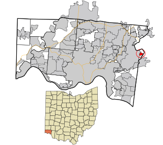
Milford Township is one of thirteen townships in Butler County, Ohio, United States. It is located between Oxford and Middletown. The township had a population of 3,523 at the 2020 census.

Hanover Township is one of thirteen townships Butler County, Ohio, United States. It is located in the west-central part of the county, midway between Hamilton and Oxford. The population of the township was 8,111 at the 2020 census. It is named for Hanover County, Virginia, where the early settlers originated.

Pettisville is an unincorporated community and census-designated place (CDP) in Clinton and German townships, Fulton County, Ohio, United States. Located at the intersection of County Road 19 and Country Road D,. As of the 2020 census the population was 469.

Brownsville is an unincorporated community and census-designated place (CDP) in northeastern Bowling Green Township, Licking County, Ohio, United States. As of the 2020 census, it had a population of 214. It lies at the intersection of U.S. Route 40 with State Route 668.
Ridgeville Corners is an unincorporated community and census-designated place (CDP) in southern Ridgeville Township, Henry County, Ohio, United States. The population was 416 at the 2020 census.
Camp Dennison is a census-designated place (CDP) just outside Indian Hill in southern Symmes Township, Hamilton County, Ohio, United States. It has a post office with the ZIP code 45111. The population was 384 at the 2020 census.
Lake Lorelei is a gated community and census-designated place in Brown County, Ohio, United States, near the village of Fayetteville. As of the 2020 census, it had a population of 1,172.

New Trenton is an unincorporated community and census-designated place (CDP) in Whitewater Township, Franklin County, Indiana. As of the 2010 census it had a population of 252. It has a ZIP code 47035.

Etna is an unincorporated community and census-designated place (CDP) in Licking County, Ohio, United States. As of the 2020 census it had a population of 1,209. It lies at an elevation of 1,069 feet (326 m) at the intersection of U.S. Route 40 and State Route 310. It was listed as a census-designated place in 2010.
Four Bridges is a census-designated place (CDP) in Liberty Township, Butler County, Ohio, United States. The population was 3,401 at the 2020 census.
Williamsdale is a census-designated place (CDP) in St. Clair Township, Butler County, Ohio, United States. The population was 578 at the 2020 census.
Canal Lewisville is an unincorporated community and census-designated place (CDP) in Coshocton County, Ohio, in the United States. As of the 2020 census it had a population of 417.

Salem Heights is an unincorporated community and census-designated place (CDP) in Columbiana County, Ohio, United States. It was first listed as a CDP prior to the 2020 census, in which its population was 336. Salem Heights sits on the 1,275-foot (389 m) Blackburn Hill, separated from the city of Salem by the valley of the Middle Fork of the Little Beaver Creek. It is part of the Salem micropolitan area.


