
The Land Ordinance of 1785 was adopted by the United States Congress of the Confederation on May 20, 1785. It set up a standardized system whereby settlers could purchase title to farmland in the undeveloped west. Congress at the time did not have the power to raise revenue by direct taxation, so land sales provided an important revenue stream. The Ordinance set up a survey system that eventually covered over 3/4 of the area of the continental United States.
The Ohio Company of Associates, also known as the Ohio Company, was a land company whose members are today credited with becoming the first non-Native American group to settle in the present-day state of Ohio. In 1788 they established Marietta, Ohio as the first permanent settlement of the new United States in the newly organized Northwest Territory.
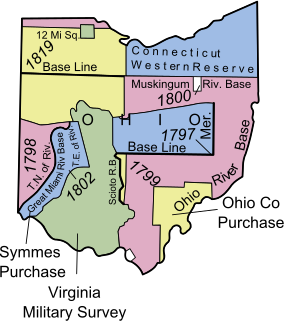
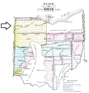
The Ohio Lands were the several grants, tracts, districts and cessions which make up what is now the U.S. state of Ohio. The Ohio Country was one of the first settled parts of the Midwest, and indeed one of the first settled parts of the United States beyond the original 13 colonies. The land that became first the anchor of the Northwest Territory and later Ohio was cobbled together from a variety of sources and owners.
The "College Township" was the full survey township located in the northwest corner of Butler County, Ohio, now corresponding to the civil township of Oxford, designated by the Ohio General Assembly to be the site of the state university now called Miami University. When Congress, on May 5, 1792, authorized the sale to John Cleves Symmes of the land known as the Symmes Purchase, one of the terms was that he would allocate a full township of land to support a university, a promise he never fulfilled. The United States Congress subsequently allowed the State of Ohio to pick a township in the public domain for a college. They chose a township in the first range in the Congress Lands, namely R1E T5.
The Refugee Tract is an area of land in Ohio, United States granted to people from British Canada who left home prior to July 4, 1776, stayed in the US until November 25, 1783 continuously, and aided the revolutionary cause.

The Seven Ranges was a land tract in eastern Ohio that was the first tract to be surveyed in what became the Public Land Survey System. The tract is 42 miles (68 km) across the northern edge, 91 miles (146 km) on the western edge, with the south and east sides along the Ohio River. It consists of all of Monroe, Harrison, Belmont and Jefferson, and portions of Carroll, Columbiana, Tuscarawas, Guernsey, Noble, and Washington County.
Dohrman Tract or Dohrman’s Grant was a land tract in eastern Ohio granted by Congress to Arnold Henry Dohrman (1749–1813), who helped the American cause in the Revolutionary War.
The Congress Lands was a group of land tracts in Ohio that made land available for sale to members of the general public through land offices in various cities, and through the General Land Office. It consisted of three groups of surveys:
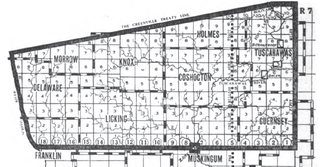
The United States Military District was a land tract in central Ohio that was established by the Congress to compensate veterans of the American Revolutionary War for their service. The tract contains 2,539,110 acres (10,275.4 km2) in Noble, Guernsey, Tuscarawas, Muskingum, Coshocton, Holmes, Licking, Knox, Franklin, Delaware, Morrow, and Marion Counties.

The Ephraim Kimberly Grant was a land tract in eastern Ohio that was granted to an American Revolutionary War veteran by Congress late in the 18th century. It was located in the Seven Ranges along the Ohio River.
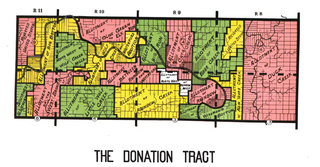
The Donation Tract was a land tract in southern Ohio that was established by the Congress late in the 18th century to buffer Ohio Company lands against Indians. Congress gave 100-acre (0.40 km2) lots to men who settled on the land. This marked the first time that federal land was given without charge to specified settlers, predating the more famous Homestead Act of 1862 by seventy years.

The Congress Lands North of the Old Seven Ranges was a land tract in northeast Ohio that was established by the Congress early in the 19th century. It is located south of the Connecticut Western Reserve and Firelands, east of the Congress Lands South and East of the First Principal Meridian, north of the United States Military District and Seven Ranges, and west of Pennsylvania.
The Congress Lands West of Miami River was a land tract in southwest Ohio that was established by the Congress late in the 18th century. It is located south of the Greenville Treaty Line, east of Indiana, and north of the Great Miami River. The original survey in 1798 contained a triangular shaped slice of land, now located in Indiana, that extended to the Greenville line as it ran from Fort Recovery to opposite the mouth of the Kentucky River.

The Congress Lands East of Scioto River was a land tract in southern Ohio that was established by the Congress late in the 18th century. It is located south of the United States Military District and Refugee Tract, west of the Old Seven Ranges, east of the Virginia Military District and north of the Ohio River, French Grant, and the Ohio Company of Associates.
The Twelve Mile Square Reservation, also called the Twelve Mile Square Reserve, was a tract of land in Ohio ceded by Indians to the United States of America in the Treaty of Greenville in 1795. This particular area of land immediately surrounding Fort Miami was considered to be of strategic importance by the United States government representatives. It was subsequently surveyed in a manner different from surrounding land, and lots sold, or granted, to settlers.
The Two Mile Square Reservation or Two Mile Square Reserve was a tract of land in Ohio ceded by Native Americans to the United States of America in the Treaty of Greenville in 1795. It was subsequently surveyed in a manner different from surrounding land, and lots sold to settlers.
North and East of the First Principal Meridian is a survey and land description in the northwest part of the American state called Ohio.

The College Lands were a tract of land in the Northwest Territory, later Ohio, that the Congress donated for the support of a university. Ohio University became the first college northwest of the Ohio River as a beneficiary of this tract.
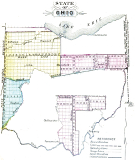
Canal Lands were tracts of land donated by the federal government to several Great Lakes states in the 19th century to encourage internal improvements and aid in funding the construction of Canals. These states sold the land tracts to private parties to raise funds for canal construction.

Moravian Indian Grants were three tracts of land in Tuscarawas County, Ohio granted by the federal government in the eighteenth century to a group of Christian Indians. In the nineteenth century, these natives moved west, and the government sold the land to white people.


