The Khmer Rouge was the name popularly given to the followers of the Communist Party of Kampuchea (CPK) and by extension to the regime through which the CPK ruled in Cambodia between 1975 and 1979. The name had originally been used in the 1950s by Norodom Sihanouk as a blanket term for the Cambodian left.

Moulin Rouge is a cabaret in Paris, France.

Baton Rouge is the capital of the U.S. state of Louisiana. Located on the eastern bank of the Mississippi River, it is the parish seat of East Baton Rouge Parish, the most populous parish in Louisiana. It is the 99th most populous city in the United States, and second-largest city in Louisiana after New Orleans. It is also the 16th most populous state capital. As of the U.S. Census Bureau's July 2017 estimate, Baton Rouge had a population of 227,549, down from 229,493 at the 2010 census. Baton Rouge is the center of Greater Baton Rouge, the second-largest metropolitan area in Louisiana, with a population of 834,159 as of 2017, up from 802,484 in 2010 and 829,719 in 2015.

The Cambodian–Vietnamese War, otherwise known in Vietnam as the Counter-offensive on the Southwestern border, was an armed conflict between the Socialist Republic of Vietnam and Democratic Kampuchea. The war began with isolated clashes along the land and maritime boundaries of Vietnam and Kampuchea between 1975 and 1978, occasionally involving division-sized military formations. On 25 December 1978, Vietnam launched a full-scale invasion of Kampuchea and subsequently occupied the country and removed the Communist Party of Kampuchea government from power.

A cave-in is a collapse of a geologic formation, mine or structure which may occur during mining or tunneling. Geologic structures prone to spontaneous cave-ins include alvar, tsingy and other limestone formations, but can also include lava tubes and a variety of other subsurface rock formations. Glacier caves and other ice formations are very prone to collapse from exposure to warm temperatures or running water.

Morondava[murunˈdav̥] is a city located in Menabe Region, of which it is the capital, in Madagascar. It is located in the delta of the Morandava River at 20°17′5″S44°19′3″E.
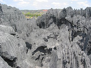
Tsingy de Bemaraha Strict Nature Reserve is a nature reserve located near the western coast of Madagascar in Melaky Region at 18°40′S44°45′E. The area was listed as a UNESCO World Heritage Site in 1990 due to the unique geography, preserved mangrove forests, and wild bird and lemur populations.

The Madagascar dry deciduous forests represent a tropical dry forest ecoregion situated in the western and northern part of Madagascar. The area has high numbers of endemic plant and animal species but has suffered large-scale clearance for agriculture. They are among the world's richest and most distinctive dry forests and included in the Global 200 ecoregions by the World Wide Fund. The area is also home to distinctive limestone karst formations known as tsingy, including the World Heritage Site of Bemaraha.
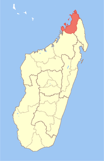
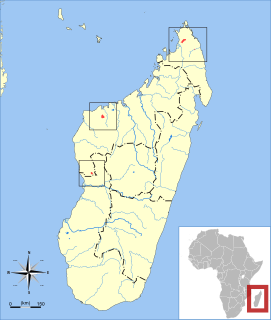
Diana is a region in Madagascar at the most northerly part of the island. It borders the regions of Sava to the southeast and Sofia to the southwest. It covers an area of 19,266 km2, and had an estimated population of 700,021 in 2013. The regional capital is Antsiranana.

Baie de Baly National Park is a National Park in Madagascar.

Tsingy de Namoroka Strict Nature Reserve, also known as Namoroka National Park, is a strict nature reserve located in the northwestern part of Madagascar in the Mahajanga Province, specifically, the Soalala District.
The Tsingy de Bemaraha National Park is a national park located in Melaky Region, northwest Madagascar. The national park centers on two geological formations: the Great Tsingy and the Little Tsingy. Together with the adjacent Tsingy de Bemaraha Strict Nature Reserve, the National Park is a UNESCO World Heritage Site.

The Manambolo River is a river in the highlands of Madagascar, located 130 km west of Antananarivo. It crosses the Tsingy de Bemaraha Strict Nature Reserve and the Maningoza Reserve.
The Tsingy tufted-tailed rat is a species of rodent in the family Nesomyidae. It is endemic to western and northern Madagascar, and has been observed mainly in dry forest. As a result of deforestation, the habitat of E. antsingy is at risk.
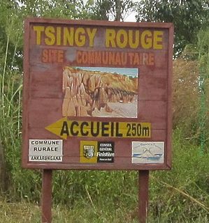
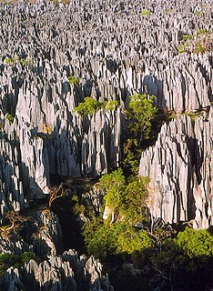
The Tsingy Rouge is a stone formation of red laterite formed by erosion of the Irodo River in the region of Diana in northern Madagascar.

Antanandrenitelo is a town in Madagascar. It belongs to the district of Antsiranana II, which is a part of Diana Region.

Route nationale 6 (RN6' is a primary highway in Madagascar of 706 km, running from Antsiranana to Ambondromamy. It crosses the regions of Diana and Sofia. It was paved in 1992.