The Amazon River in South America is the largest river by discharge volume of water in the world, and the longest or second-longest river system in the world, a title which is disputed with the Nile.

Yangtze or Yangzi is the longest river in Eurasia, the third-longest in the world. It rises at Jari Hill in the Tanggula Mountains of the Tibetan Plateau and flows 6,300 km (3,915 mi) in a generally easterly direction to the East China Sea. It is the fifth-largest primary river by discharge volume in the world. Its drainage basin comprises one-fifth of the land area of China, and is home to nearly one-third of the country's population.

The Ganges is a trans-boundary river of Asia which flows through India and Bangladesh. The 2,525 km (1,569 mi) river rises in the western Himalayas in the Indian state of Uttarakhand. It flows south and east through the Gangetic plain of North India, receiving the right-bank tributary, the Yamuna, which also rises in the western Indian Himalayas, and several left-bank tributaries from Nepal that account for the bulk of its flow. In West Bengal state, India, a feeder canal taking off from its right bank diverts 50% of its flow southwards, artificially connecting it to the Hooghly River. The Ganges continues into Bangladesh, its name changing to the Padma. It is then joined by the Jamuna, the lower stream of the Brahmaputra, and eventually the Meghna, forming the major estuary of the Ganges Delta, and emptying into the Bay of Bengal. The Ganges–Brahmaputra–Meghna system is the second-largest river on earth by discharge.

The Indus is a transboundary river of Asia and a trans-Himalayan river of South and Central Asia. The 3,120 km (1,940 mi) river rises in mountain springs northeast of Mount Kailash in Western Tibet, flows northwest through the disputed region of Kashmir, bends sharply to the left after the Nanga Parbat massif, and flows south-by-southwest through Pakistan, before emptying into the Arabian Sea near the port city of Karachi.

The Mississippi River is the primary river, and second-longest river, of the largest drainage basin in the United States. From its traditional source of Lake Itasca in northern Minnesota, it flows generally south for 2,340 miles (3,766 km) to the Mississippi River Delta in the Gulf of Mexico. With its many tributaries, the Mississippi's watershed drains all or parts of 32 U.S. states and two Canadian provinces between the Rocky and Appalachian mountains. The main stem is entirely within the United States; the total drainage basin is 1,151,000 sq mi (2,980,000 km2), of which only about one percent is in Canada. The Mississippi ranks as the thirteenth-largest river by discharge in the world. The river either borders or passes through the states of Minnesota, Wisconsin, Iowa, Illinois, Missouri, Kentucky, Tennessee, Arkansas, Mississippi, and Louisiana.

The Nile is a major north-flowing river in northeastern Africa. It flows into the Mediterranean Sea. The Nile is the longest river in Africa and has historically been considered the longest river in the world, though this has been contested by research suggesting that the Amazon River is slightly longer. Of the world's major rivers, the Nile is one of the smallest, as measured by annual flow in cubic metres of water. About 6,650 km (4,130 mi) long, its drainage basin covers eleven countries: the Democratic Republic of the Congo, Tanzania, Burundi, Rwanda, Uganda, Kenya, Ethiopia, Eritrea, South Sudan, Sudan, and Egypt. In particular, the Nile is the primary water source of Egypt, Sudan and South Sudan. Additionally, the Nile is an important economic river, supporting agriculture and fishing.

The Rhine is one of the major European rivers. The river begins in the Swiss canton of Graubünden in the southeastern Swiss Alps. It forms part of the Swiss-Liechtenstein, Swiss-Austrian, and Swiss-German borders. After that the Rhine defines much of the Franco-German border, after which it flows in a mostly northerly direction through the German Rhineland. Finally in Germany, the Rhine turns into a predominantly westerly direction and flows into the Netherlands where it eventually empties into the North Sea. It drains an area of 9,973 km2 and its name derives from the Celtic Rēnos. There are also two German states named after the river, North Rhine-Westphalia and Rhineland-Palatinate.

The Jordan River or River Jordan, also known as Nahr Al-Sharieat, is a 251-kilometre-long (156 mi) river in the Levant that flows roughly north to south through the freshwater Sea of Galilee and on to the salt water Dead Sea. The river passes by Jordan, Syria, Israel, and the Palestinian territories.

The Hudson River is a 315-mile (507 km) river that flows from north to south primarily through eastern New York, United States. It originates in the Adirondack Mountains of upstate New York at Henderson Lake in the town of Newcomb, and flows southward through the Hudson Valley to the New York Harbor between New York City and Jersey City, eventually draining into the Atlantic Ocean at Upper New York Bay. The river serves as a physical boundary between the states of New Jersey and New York at its southern end. Farther north, it marks local boundaries between several New York counties. The lower half of the river is a tidal estuary, deeper than the body of water into which it flows, occupying the Hudson Fjord, an inlet that formed during the most recent period of North American glaciation, estimated at 26,000 to 13,300 years ago. Even as far north as the city of Troy, the flow of the river changes direction with the tides.

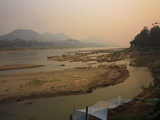
The Mekong or Mekong River is a trans-boundary river in East Asia and Southeast Asia. It is the world's twelfth-longest river and the third-longest in Asia with an estimated length of 4,909 km (3,050 mi) and a drainage area of 795,000 km2 (307,000 sq mi), discharging 475 km3 (114 cu mi) of water annually. From its headwaters in the Tibetan Plateau, the river runs through Southwest China, Myanmar, Laos, Thailand, Cambodia, and southern Vietnam. The extreme seasonal variations in flow and the presence of rapids and waterfalls in the Mekong make navigation difficult. Even so, the river is a major trade route between Tibet and Southeast Asia. The construction of hydroelectric dams along the Mekong in the 2000s through the 2020s has caused serious problems for the river's ecosystem, including the exacerbation of drought.
A tributary, or an affluent, is a stream or river that flows into a larger stream, river, or a lake. A tributary does not flow directly into a sea or ocean. Tributaries, and the main stem river into which they flow, drain the surrounding drainage basin of its surface water and groundwater, leading the water out into an ocean.
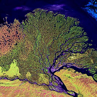
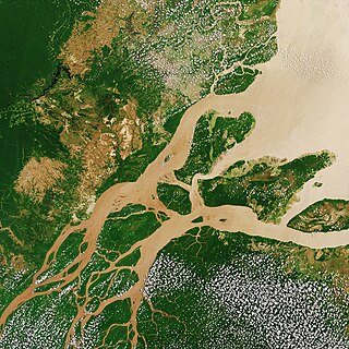
A river delta is a landform shaped like a triangle, created by the deposition of sediment that is carried by a river and enters slower-moving or stagnant water. This occurs at a river mouth, when it enters an ocean, sea, estuary, lake, reservoir, or another river that cannot carry away the supplied sediment. It is so named because its triangle shape resembles the uppercase Greek letter delta, Δ. The size and shape of a delta are controlled by the balance between watershed processes that supply sediment, and receiving basin processes that redistribute, sequester, and export that sediment. The size, geometry, and location of the receiving basin also plays an important role in delta evolution.

The Colorado River is one of the principal rivers in the Southwestern United States and in northern Mexico. The 1,450-mile-long (2,330 km) river, the 5th longest in the United States, drains an expansive, arid watershed that encompasses parts of seven U.S. states and two Mexican states. The name Colorado derives from the Spanish language for "colored reddish" due to its heavy silt load. Starting in the central Rocky Mountains of Colorado, it flows generally southwest across the Colorado Plateau and through the Grand Canyon before reaching Lake Mead on the Arizona–Nevada border, where it turns south toward the international border. After entering Mexico, the Colorado approaches the mostly dry Colorado River Delta at the tip of the Gulf of California between Baja California and Sonora.

The Ozarks, also known as the Ozark Mountains, Ozark Highlands or Ozark Plateau, is a physiographic region in the U.S. states of Missouri, Arkansas, Oklahoma and the extreme southeastern corner of Kansas. The Ozarks cover a significant portion of northern Arkansas and most of the southern half of Missouri, extending from Interstate 40 in central Arkansas to Interstate 70 in central Missouri.

Joan Alexandra Molinsky, known professionally as Joan Rivers, was an American comedian, actress, producer, writer, and television host. She was noted for her blunt, often controversial comedic persona that was heavily self-deprecating and acerbic, especially towards celebrities and politicians, delivered in her signature New York accent. She is considered a pioneer of women in comedy. She received an Emmy Award and a Grammy Award, as well as nomination for a Tony Award.

The Yamuna is the second-largest tributary river of the Ganges by discharge and the longest tributary in India. Originating from the Yamunotri Glacier at a height of about 4,500 m (14,800 ft) on the southwestern slopes of Bandarpunch peaks of the Lower Himalaya in Uttarakhand, it travels 1,376 kilometres (855 mi) and has a drainage system of 366,223 square kilometres (141,399 sq mi), 40.2% of the entire Ganges Basin. It merges with the Ganges at Triveni Sangam, Prayagraj, which is a site of the Kumbh Mela, a Hindu festival held every 12 years.
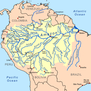
The Amazon basin is the part of South America drained by the Amazon River and its tributaries. The Amazon drainage basin covers an area of about 7,000,000 km2 (2,700,000 sq mi), or about 35.5 percent of the South American continent. It is located in the countries of Bolivia, Brazil, Colombia, Ecuador, Guyana, Peru, Suriname, and Venezuela, as well as the territory of French Guiana.

A stream is a continuous body of surface water flowing within the bed and banks of a channel. Depending on its location or certain characteristics, a stream may be referred to by a variety of local or regional names. Long, large streams are usually called rivers, while smaller, less voluminous and more intermittent streams are known as streamlets, brooks or creeks.

The Danube is the second-longest river in Europe, after the Volga in Russia. It flows through Central and Southeastern Europe, from the Black Forest south into the Black Sea. A large and historically important river, it was once a frontier of the Roman Empire. In the 21st century, it connects ten European countries, running through their territories or marking a border. Originating in Germany, the Danube flows southeast for 2,850 km (1,770 mi), passing through or bordering Austria, Slovakia, Hungary, Croatia, Serbia, Romania, Bulgaria, Moldova, and Ukraine. Among the many cities on the river are four national capitals: Vienna, Bratislava, Budapest, and Belgrade. Its drainage basin amounts to 817,000 km² and extends into nine more countries.

A river mouth is where a river flows into a larger body of water, such as another river, a lake/reservoir, a bay/gulf, a sea, or an ocean. At the river mouth, sediments are often deposited due to the slowing of the current, reducing the carrying capacity of the water. The water from a river can enter the receiving body in a variety of different ways. The motion of a river is influenced by the relative density of the river compared to the receiving water, the rotation of the Earth, and any ambient motion in the receiving water, such as tides or seiches.
