
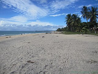
Madagascar is a large island in the Indian Ocean off the eastern coast of Southern Africa, east of Mozambique. It has a total area of 587,040 square kilometres (226,660 sq mi) with 581,540 square kilometres (224,530 sq mi) of land and 5,500 square kilometres (2,100 sq mi) of water. Madagascar is the fourth-largest island and the second-largest island country in the world. The highest point is Maromokotro, in the Tsaratanana Massif region in the north of the island, at 2,876 metres (9,436 ft). The capital Antananarivo is in the Central Highlands near the centre of the island. It has the 25th largest exclusive economic zone of 1,225,259 km2 (473,075 sq mi). Madagascar is 400 kilometres east of mainland Africa.

The ecoregions of Madagascar, as defined by the World Wildlife Fund, include seven terrestrial, five freshwater, and two marine ecoregions. Madagascar's diverse natural habitats harbour a rich fauna and flora with high levels of endemism, but most ecoregions suffer from habitat loss.

The Madagascar dry deciduous forests represent a tropical dry forest ecoregion situated in the western and northern part of Madagascar. The area has high numbers of endemic plant and animal species but has suffered large-scale clearance for agriculture. They are among the world's richest and most distinctive dry forests and included in the Global 200 ecoregions by the World Wide Fund. The area is also home to distinctive limestone karst formations known as tsingy, including the World Heritage Site of Bemaraha.
Sava is a region in northern Madagascar. Its capital is Sambava. Until 2009 Sava belonged to Antsiranana Province. The region is situated at the northern part of the east coast of Madagascar. It is bordered by the region Diana to the north, Sofia to the west, and Analanjirofo to the south. As of 2018, its population was 1,123,013 and the total area is 25,518 km2 (9,853 sq mi). The region contains wild areas such as Marojejy National Park.
Boriziny is a city in western Madagascar in Sofia Region. The population of the commune urbaine was 22,573 in 2018.

Mampikony urban municipality in northern Madagascar. It belongs to the district of Mampikony, which is a part of Sofia Region. The population of the municipality was 28,593 in 2018.
Bedotia is a genus of the family Bedotiidae of fishes endemic to Madagascar.
Nosiarina is a rural municipality in northern Madagascar. It belongs to the district of Sambava, which is a part of Sava Region. It is situated at the Bemarivo River and the Route Nationale 5a between Sambava and Vohemar.
Bemanevika is a town and commune in northern Madagascar. It belongs to the district of Sambava, which is a part of Sava Region. The population of the commune was estimated to be approximately 13,000 in 2001 commune census.

Antindra is a municipality in northern Madagascar. It belongs to the district of Sambava, which is a part of Sava Region. The population of the commune was estimated to be approximately 16,000 in 2001 commune census.
Anjialava is a rural municipality in northern Madagascar. It belongs to the district of Sambava, which is a part of Sava Region. The population of the commune was estimated to be approximately 9,000 in 2001 commune census.

Ambohimalaza is a municipality in northern Madagascar. It belongs to the district of Sambava, which is a part of Sava Region. The population of the commune was estimated to be approximately 8,000 in 2001 commune census.
Marojejy National Park is a national park in the Sava region of northeastern Madagascar. It covers 55,500 ha (214 sq mi) and is centered on the Marojejy Massif, a mountain chain that rises to an elevation of 2,132 m (6,995 ft). Access to the area around the massif was restricted to research scientists when the site was set aside as a strict nature reserve in 1952. In 1998, it was opened to the public when it was converted into a national park. It became part of the World Heritage Site known as the Rainforests of the Atsinanana in 2007. "Unique in the world, a place of dense, jungly rainforests, sheer high cliffs, and plants and animals found nowhere else on earth", Marojejy National Park has received plaudits in the New York Times and Smithsonian Magazine for its natural beauty and rich biodiversity that encompasses critically endangered members of the silky sifaka. To that end, a global consortium of conservation organizations, including the Lemur Conservation Foundation, Duke Lemur Center and Madagascar National Parks, have sought to promote research and conservation programs in Marojejy National Park, neighboring Anjanaharibe-Sud Reserve and Antanetiambo Private Reserve, to protect the endemic flora and fauna that reside in northeastern Madagascar. In addition, these organizations have implemented a variety of community-based initiatives to mitigate human encroachment on the park, such as poaching and selective logging, by encouraging local communities to engage in afforestation and silvicultural initiatives to promote a sustainable alternative to mining, slash-and-burn agriculture, and wood collection.
Bemarivo Reserve is a wildlife reserve 12 km from Besalampy in the region of Melaky in the north-west of Madagascar. It was created in 1956 and covers an area of 12,080 hectares. The reserve is known for its fauna especially endemic birds.
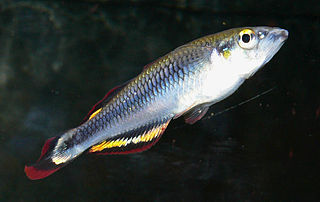
Paretroplus loisellei is a vulnerable species of cichlid fish from the Mahanara River basin north of Sambava in northeastern Madagascar. Until its scientific description in 2011, this population was usually referred to as Paretroplus sp. nov. "Ventitry" or included in P. damii, which it resembles. It reaches about 15 centimetres (5.9 in) in length, and is threatened by habitat loss and introduced species. The similar named Ptychochromis loisellei is also restricted to the Mahanara River basin. The specific name honours Paul V. Loiselle, Emeritus Curator of Freshwater Fishes at the New York Aquarium and a researcher in, and campaigner for the conservation of, the freshwater fish of Madagascar.

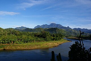
The Lokoho River is located in northern Madagascar. It drains to the north-east coast, into the Indian Ocean. It drains the southern half of the Marojejy Massif. Its mouth is situated 25 km in the south of Sambava, near Farahalana.

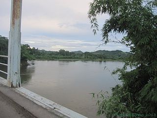
The Bemarivo river in Sofia Region, is located in northern Madagascar. It drains to the northern coast, into the Anjobony shortly before the Sofia River, near Boriziny.
The Anjobony river in Sofia Region is located in northern Madagascar. It drains to the northern coast. Its main affluent is the Bemarivo (Sofia). near Boriziny.
Bemarivo is the name of several municipalities and rivers in Madagascar:

