Madagascar is a large island in the Indian Ocean off the eastern coast of Southern Africa, east of Mozambique. It has a total area of 587,040 square kilometres (226,660 sq mi) with 581,540 square kilometres (224,530 sq mi) of land and 5,500 square kilometres (2,100 sq mi) of water. Madagascar is the fourth-largest island and the second-largest island country in the world. The highest point is Maromokotro, in the Tsaratanana Massif region in the north of the island, at 2,876 metres (9,436 ft). The capital Antananarivo is in the Central Highlands near the centre of the island. It has the 25th largest exclusive economic zone of 1,225,259 km2 (473,075 sq mi). Madagascar is 400 kilometres east of mainland Africa.
Paved and unpaved roadways, as well as railways, provide the main forms of transport in Madagascar. Madagascar has approximately 31,640 km (19,660 mi) of paved roads and 836 km of rail lines. In 2010, Madagascar had 432 km (270 mi) of navigable waterways.

The Toamasina Province is a former province of Madagascar with an area of 71,911 km². It had a population of 2,855,600 (2004). Its capital was Toamasina, the most important seaport of the country. The province was also known as Tamatave Province.

Toamasina, meaning "like salt" or "salty", unofficially and in French Tamatave, is the capital of the Atsinanana region on the east coast of Madagascar on the Indian Ocean. The city is the chief seaport of the country, situated 215 km (134 mi) northeast of its capital and biggest city Antananarivo. In 2018 Toamasina had a population of 325,857.

Mahavelona, is a town in the district of Toamasina II, in the region of Atsinanana, on the northern part of the east coast of Madagascar.

The Canal des Pangalanes is a canal that consists of a series of natural rivers, waterways and human-made lakes that extends for over 654 kilometres (410 mi) and runs down the east coast of Madagascar from Toamasina to Farafangana. It is used primarily for transportation and fishing, and it has unspoiled natural beaches that are visited by tourists. An initial area of the canal in Toamasina is straight, while subsequent areas have curves, lagoons, connected lakes and swamps.

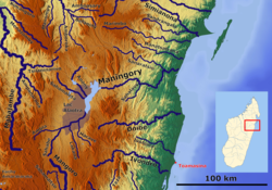
Alaotra-Mangoro is a region in eastern Madagascar. It borders Sofia Region in north, Analanjirofo in northeast, Atsinanana in east, Vakinankaratra in southwest, Analamanga in west and Betsiboka in northwest. The capital of the region is Ambatondrazaka, and the population was 1,255,514 in 2018. The area of the region is 31,948 km2 (12,335 sq mi).
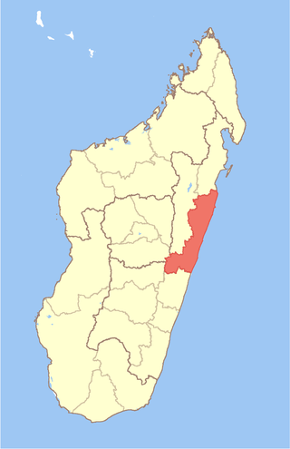
Atsinanana is a coastal region in eastern Madagascar. It borders Analanjirofo region in the north, Alaotra-Mangoro in the west, Vakinankaratra and Amoron'i Mania in the southwest, and Vatovavy in the south. The region contains over 285km of coastline, which includes many beaches and cultural heritage sites.

Betampona Reserve is a nature reserve in the Atsinanana Region of Madagascar. It is located 40 km northwest of Toamasina and was established in 1927. The area of the reserve is 29.2 km2.

Intense Tropical Cyclone Geralda was a powerful tropical cyclone that caused catastrophic damage in Madagascar in late January 1994, among the strongest to hit the country. It was also the most intense tropical cyclone worldwide in 1994. Cyclone Geralda originated from an area of low pressure over the Indian Ocean on 25 January. Over the following few days, the depression underwent gradual intensification, reaching its peak intensity with ten-minute sustained winds of 205 km/h (127 mph) on 31 January. It eventually made landfall near Toamasina, Madagascar after weakening from its peak intensity, and substantially weakened within hours of moving onshore. By 5 February, Geralda had degenerated into a land depression, and became extratropical three days later. Geralda's remnants dissipated on 12 February.

Tropical Cyclone Kesiny was the first recorded tropical cyclone – the equivalent of a minimal hurricane – to make landfall in the month of May in the south-west Indian Ocean. The final named storm of the busy 2001–02 South-West Indian Ocean cyclone season, Kesiny formed on May 2 from a trough near the equator. Its formation was the result of an increase in the Madden–Julian oscillation, which also contributed to a twin storm in the north Indian Ocean that hit Oman, and another set of storms in northeast and southeast Indian Ocean. Kesiny initially moved to the southeast, but later turned to the southwest due to a strengthening ridge. On May 6, it intensified into a tropical cyclone, but later weakened and was not expected to re-strengthen. However, Kesiny developed an eye and re-intensified into a tropical cyclone on May 9, reaching peak winds of 130 km/h (81 mph) before striking Madagascar about 60 km (37 mi) southeast of Antsiranana. It weakened while crossing the country, and after turning to the south it struck the country again before dissipating on May 11.
Mahanoro is a rural municipality located in the Atsinanana region of eastern Madagascar, along the coast.

Route nationale 2 (RN2) is a primary highway in Madagascar. The route runs from the capital city of Antananarivo to Toamasina, a city on the eastern coast of the Madagascar.

Andevoranto is a rural municipality in the Brickaville District, Atsinanana Region, Madagascar.

Tropical Cyclone Honorinina was a powerful tropical cyclone that struck eastern Madagascar in March 1986. The eighth named storm of the season, Honorinina formed on 9 March to the south of Diego Garcia. It moved generally to the west-southwest due to a ridge to the south, gradually intensifying. On 12 March, the Météo France office in Réunion (MFR) upgraded Honorinina to tropical cyclone status, which is the equivalent of a minimal hurricane. On the next day, the cyclone attained maximum sustained winds of 150 km/h (93 mph) while in the vicinity of Tromelin Island. Honorinina weakened subsequently before making landfall about 40 km (25 mi) north of Toamasina, Madagascar with winds of 135 km/h (84 mph). The storm weakened further over land, moving southwestward across the country. It emerged into the Mozambique Channel and became extratropical on 18 March. Honorinina then turned to the southeast, dissipating on 23 March.
Ambalona is a river in eastern Madagascar. It flows into the Indian Ocean south of Toamasina.

Route nationale 5 (RN5) is a primary highway in Madagascar of 402 km. The route runs from Toamasina to Maroantsetra, a city on the eastern coast of the Madagascar.
Mananara Nord National Park is a national park near Mananara Nord in the Analanjirofo Region of Madagascar.
Ambodilazana is a rural commune in the district of Toamasina II (district), in the region of Atsinanana, on the east coast of Madagascar.

Fanandrana is a rural commune in the district of Toamasina II (district), in the region of Atsinanana, on the east coast of Madagascar. It is situated at the National road RN 2 at 26 km from Toamasina. The Ivondro River flows through the center of Fanandrana, and the Fanandrana river in its south.