Jackson County, Oklahoma

Last updated

Jackson County
Jackson courthouse.jpg
Map of Oklahoma highlighting Jackson County.svg
Location within the U.S. state of Oklahoma
Oklahoma in United States.svg
Oklahoma's location within the U.S.
Coordinates: 34°35′N99°25′W / 34.59°N 99.41°W / 34.59; -99.41
CountryFlag of the United States.svg United States
StateFlag of Oklahoma.svg  Oklahoma
Founded1907
Named for Stonewall Jackson
Seat Altus
Largest cityAltus
Area
  Total804 sq mi (2,080 km2)
  Land803 sq mi (2,080 km2)
  Water1.6 sq mi (4 km2)  0.2%
Population
 (2020)
  Total24,785
  Density31/sq mi (12/km2)
Time zone UTC−6 (Central)
  Summer (DST) UTC−5 (CDT)
Congressional district 3rd
Website jackson.okcounties.org

Jackson County is a county located in the southwestern corner of the U.S. state of Oklahoma. As of the 2020 census, the population was 24,785. [1] Its county seat is Altus. [2] According to the Encyclopedia of Oklahoma History and Culture, the county was named for two historical figures: President Andrew Jackson and Confederate General Stonewall Jackson. [3] One source states that the county was named only for the former president, [4] while an earlier source states it was named only for General Stonewall Jackson. [5]

Contents

Jackson County comprises the Altus, OK micropolitan statistical area.

History

After a dispute over the Adams-Onís Treaty of 1819, both the governments of the United States and the state of Texas claimed ownership of some 1,500,000 acres (6,100 km2) in what was then operated as Greer County, Texas. Litigation followed, and in the case of United States v. State of Texas 162 U.S. 1 (1896), issued on March 16, the Supreme Court, having original jurisdiction over the case, decided in favor of the United States. Greer County was then assigned to the Oklahoma Territory on May 4, 1896. When Oklahoma became the 46th U.S. state (November 16, 1907), old "Greer County" was divided into Greer, Jackson, and part of Beckham counties.

Altus was originally designated as the seat of Jackson County. Olustee vied in an unsuccessful bid to replace Altus as the seat in an election on July 18, 1908. [3]

Geography

According to the U.S. Census Bureau, the county has a total area of 804 square miles (2,080 km2), of which 803 square miles (2,080 km2) is land and 1.6 square miles (4.1 km2) (0.2%) is water. [6]

Most of the county is within the Red Bed Plains physiographic region. The western part lies in the Gypsum Hills and the northeastern part is in the Wichita Mountains. The county is drained by the Red River and its tributaries, the North Fork of the Red River and the Salt Fork of the Red River. [3]

Major highways

Adjacent counties

Demographics

Historical population
CensusPop.Note
1910 23,737
1920 22,141−6.7%
1930 28,91030.6%
1940 22,708−21.5%
1950 20,082−11.6%
1960 29,73648.1%
1970 30,9023.9%
1980 30,356−1.8%
1990 28,764−5.2%
2000 28,439−1.1%
2010 26,446−7.0%
2020 24,785−6.3%
U.S. Decennial Census [7]
1790-1960 [8] 1900-1990 [9]
1990-2000 [10] 2010 [11]

As of the census [12] of 2000, there were 28,439 people, 10,590 households, and 7,667 families residing in the county. The population density was 35 people per square mile (14 people/km2). There were 12,377 housing units at an average density of 15 units per square mile (5.8/km2). The racial makeup of the county was 76.14% White, 8.03% Black or African American, 1.74% Native American, 1.16% Asian, 0.17% Pacific Islander, 9.34% from other races, and 3.42% from two or more races. 15.63% of the population were Hispanic or Latino of any race. By 2020, its population declined to 24,785. [1]

There were 10,590 households, out of which 38.10% had children under the age of 18 living with them, 57.80% were married couples living together, 10.70% had a female householder with no husband present, and 27.60% were non-families. 24.20% of all households were made up of individuals, and 9.70% had someone living alone who was 65 years of age or older. The average household size was 2.61 and the average family size was 3.11.

In the county, the population was spread out, with 29.20% under the age of 18, 10.30% from 18 to 24, 29.00% from 25 to 44, 19.60% from 45 to 64, and 11.90% who were 65 years of age or older. The median age was 33 years. For every 100 females there were 99.10 males. For every 100 females age 18 and over, there were 94.80 males.

The median income for a household in the county was $30,737, and the median income for a family was $38,265. Males had a median income of $28,240 versus $19,215 for females. The per capita income for the county was $15,454. About 13.60% of families and 16.20% of the population were below the poverty line, including 20.70% of those under age 18 and 14.40% of those age 65 or over.

Politics

Voter Registration and Party Enrollment as of June 30, 2023 [13]
PartyNumber of VotersPercentage
Democratic 2,85322.66%
Republican 7,32358.16%
Others2,41519.18%
Total12,591100%
United States presidential election results for Jackson County, Oklahoma [14]
Year Republican Democratic Third party
No.%No.%No.%
2020 6,39277.75%1,64620.02%1832.23%
2016 5,96976.47%1,47318.87%3644.66%
2012 5,96575.33%1,95424.67%00.00%
2008 6,71974.80%2,26425.20%00.00%
2004 7,02475.89%2,23224.11%00.00%
2000 5,59168.53%2,51530.82%530.65%
1996 4,42251.53%3,24537.81%91510.66%
1992 3,89341.33%3,27334.75%2,25423.93%
1988 4,42355.28%3,54244.27%360.45%
1984 5,77365.64%2,99634.06%260.30%
1980 4,32750.58%4,03147.12%1962.29%
1976 3,18939.07%4,91460.20%600.74%
1972 5,51971.61%2,05426.65%1341.74%
1968 2,24830.36%3,37145.52%1,78624.12%
1964 2,36628.64%5,89471.36%00.00%
1960 3,37547.30%3,76152.70%00.00%
1956 2,34334.57%4,43565.43%00.00%
1952 2,62734.80%4,92165.20%00.00%
1948 92314.48%5,45085.52%00.00%
1944 1,31321.20%4,86678.59%130.21%
1940 1,54024.03%4,83275.41%360.56%
1936 1,09516.66%5,43582.71%410.62%
1932 6039.48%5,75990.52%00.00%
1928 3,44057.72%2,49341.83%270.45%
1924 94124.74%2,34261.57%52113.70%
1920 1,34530.18%2,69460.46%4179.36%
1916 40912.77%2,09665.44%69821.79%
1912 58819.02%1,81958.83%68522.15%

Economy

The county's economy has been based on farming and livestock since its inception. The major crops include cotton, wheat, corn, alfalfa, and hay. Barley and sorghum became major crops in the late 1940s. Livestock consisted of horses, cattle, mules, swine and sheep. Altus Air Force Base is the county's largest non-farm employer. There were 16 manufacturers in the county by 2000. These included Altus Athletic Manufacturing, the Bar-S Foods Company, and the Republic Gypsum plant. [3] (The Luscombe Aircraft manufacturing plant, later Quartz Mountain Aerospace, went bankrupt in 2009.) [15]

Education

The Western Oklahoma State College (WOSC) and the Southwest Technology Center, both in Altus, offer higher education opportunities in Jackson County. [3]

Communities

See also

Related Research Articles

<span class="mw-page-title-main">Wilbarger County, Texas</span> County in Texas, United States

Wilbarger County is a county located in the North Texas region of the U.S. state of Texas. As of the 2020 census, the population was 12,887. The county seat is Vernon. The county was created in 1858 and later organized in 1881. Wilbarger is named for Josiah Pugh Wilbarger and Mathias Wilbarger, two early settlers.

<span class="mw-page-title-main">Jackson County, Texas</span> County in Texas, United States

Jackson County is a county in the U.S. state of Texas. As of the 2020 census its population was 14,988. Its county seat is Edna. The county was created in 1835 as a municipality in Mexico and in 1836 was organized as a county. It is named for Andrew Jackson, President of the United States from 1829 to 1837.

<span class="mw-page-title-main">Texas County, Oklahoma</span> County in Oklahoma, United States

Texas County is a county located in the panhandle of the U.S. state of Oklahoma. Its county seat is Guymon. As of the 2020 census, the population was 21,384. It is the second largest county in Oklahoma, based on land area, and is named for Texas, the state that adjoins the county to its south. Texas County comprises the Guymon, OK Micropolitan Statistical Area. The county economy is largely based on farming and cattle production. It is one of the top-producing counties in the U.S. for wheat, cattle, and hogs. It also lies within the noted Hugoton-Panhandle natural gas field.

<span class="mw-page-title-main">Marshall County, Oklahoma</span> County in Oklahoma, United States

Marshall County is a county located on the south central border of Oklahoma. As of the 2020 census, the population was 15,312. Its county seat is Madill. The county was created at statehood in 1907 from the former Pickens County of the Chickasaw Nation. It was named to honor the maiden name of the mother of George Henshaw, a member of the 1906 Oklahoma Constitutional Convention. The county and its cities are part of the Texoma region.

<span class="mw-page-title-main">Kiowa County, Oklahoma</span> County in Oklahoma, United States

Kiowa County is a county located in the southwestern part of the U.S. state of Oklahoma. As of the 2020 census, the population was 8,509. Its county seat is Hobart. The county was created in 1901 as part of Oklahoma Territory. It was named for the Kiowa people.

<span class="mw-page-title-main">Harmon County, Oklahoma</span> County in Oklahoma, United States

Harmon County is a county in the southwest corner of the U.S. state of Oklahoma. As of the 2020 Census, the population was 2,488, making it the second-least populous county in Oklahoma, behind only Cimarron County. It has lost population in every census since 1930. The county seat is Hollis.

<span class="mw-page-title-main">Greer County, Oklahoma</span> County in Oklahoma, United States

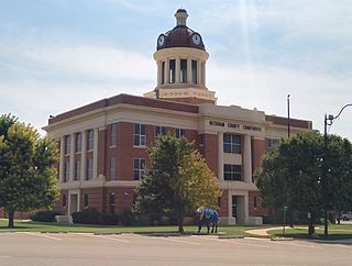
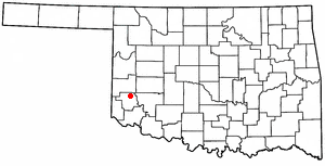
Greer County is a county located along the southwest border of the U.S. state of Oklahoma. As of the 2020 census, the population was 5,491. Its county seat is Mangum. From 1860 to 1896, the state of Texas claimed an area known as Greer County, Texas, which included present-day Greer County along with neighboring areas. In 1896 it was designated as a county in Oklahoma Territory under a ruling by the US Supreme Court. The rural Greer County is home to Quartz Mountain State Park, near the community of Lone Wolf, Oklahoma. It is also home to the Oklahoma State Reformatory, located in Granite. Its population has declined since 1930 due to changes in agriculture and migration to cities for work.

<span class="mw-page-title-main">Garvin County, Oklahoma</span> County in Oklahoma, United States

Garvin County is a county in south-central Oklahoma, United States. As of the 2020 census, the population was 25,656. Its county seat is Pauls Valley. In 1906, delegates to Constitution Convention formed Garvin County from part of the Chickasaw Nation, Indian Territory. The county was named for Samuel J. Garvin, a local Chickasaw rancher, merchant and banker. Its economy is largely based on farming, ranching and oil production.

<span class="mw-page-title-main">Cotton County, Oklahoma</span> County in Oklahoma, United States

Cotton County is a county located in the U.S. state of Oklahoma. As of the 2020 census, the population was 5,527. Its county seat is Walters. When Oklahoma achieved statehood in 1907, the area which is now Cotton County fell within the boundaries of Comanche County. It was split off in 1912, becoming the last county created in Oklahoma; it was named for the county's primary crop.

<span class="mw-page-title-main">Carter County, Oklahoma</span> County in Oklahoma, United States

Carter County is a county in the U.S. state of Oklahoma. As of the 2020 census, the population was 48,003. Its county seat is Ardmore. The county was named for Captain Ben W. Carter, a Cherokee who lived among the Chickasaw.

<span class="mw-page-title-main">Beckham County, Oklahoma</span> County in Oklahoma, United States

Beckham County is a county located on the western border of the U.S. state of Oklahoma. As of the 2020 census, the population was 22,410. Its county seat is Sayre. Founded upon statehood in 1907, Beckham County was named for J. C. W. Beckham, who was Governor of Kentucky and the first popularly elected member of the United States Senate from Kentucky. Beckham County comprises the Elk City, OK Micropolitan Statistical Area.

<span class="mw-page-title-main">Granite, Oklahoma</span> Town in Oklahoma, United States

Granite is a town in Greer County, Oklahoma, United States. The population was 1,628 at the 2020 census.

<span class="mw-page-title-main">Mangum, Oklahoma</span> City in Oklahoma, United States

Mangum is a city in and county seat of Greer County, Oklahoma, United States. The population was 2,762 as of the 2020 United States census. Mangum was originally part of Old Greer County in the Texas panhandle. The community was named for A. S. Mangum, who owned the land on which the town was founded in 1882. It became part of the Oklahoma Territory in 1896, and thus part of the state of Oklahoma on November 16, 1907.

<span class="mw-page-title-main">Willow, Oklahoma</span> Town in Oklahoma, United States

Willow is a town in Greer County, Oklahoma, United States. The population was 119 as of the 2020 United States census. It is situated about 13 miles north of the county seat of Mangum, just west of the concurrent US Route 283 and Oklahoma State Highway 34.

<span class="mw-page-title-main">Altus, Oklahoma</span> City in Oklahoma, United States

Altus is a city in and the county seat of Jackson County, Oklahoma, United States. The population was 18,729 at the 2020 census.

<span class="mw-page-title-main">East Duke, Oklahoma</span> Town in Oklahoma, United States

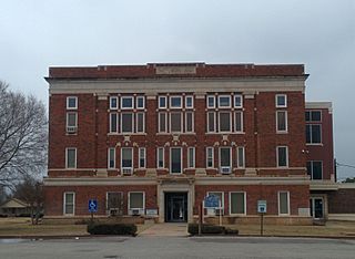
East Duke, now known as Duke, is a town in Jackson County, Oklahoma, United States. The population was 394 as of the 2020 United States census. It is located about 14 miles west of the county seat of Altus, and is located at the intersection of US Route 62 and Oklahoma State Highway 34.

<span class="mw-page-title-main">Martha, Oklahoma</span> Town in Oklahoma, United States

Martha is a town in Jackson County, Oklahoma, United States. The population was 162 as of the 2020 United States census. The town is located about 9 driving miles north-northwest of the county seat of Altus.

<span class="mw-page-title-main">Olustee, Oklahoma</span> Town in Oklahoma, United States

Olustee is a town in Jackson County, Oklahoma, United States. "Olustee" is said to be a Seminole word meaning "pond" or from the Creek (Muscogee) language ue-lvste (/oy-lást-i/) meaning "black water", and being taken from the Battle of Olustee in Florida. The population was 468 as of the 2020 United States census.

<span class="mw-page-title-main">Petrolia, Texas</span> City in Texas, United States

Petrolia is a city in Clay County, Texas, United States. It is part of the Wichita Falls, Texas Metropolitan Statistical Area. The population was 686 at the 2010 census, down from 782 at the 2000 census.

<span class="mw-page-title-main">Quanah, Texas</span> City in Texas, United States

Quanah is a city in and the county seat of Hardeman County, Texas, United States. As of the 2010 census the population was 2,641, down from 3,022 at the 2000 census.

References

  1. 1 2 "Jackson County, Oklahoma". United States Census Bureau . Retrieved May 13, 2023.
  2. "Find a County". National Association of Counties. Archived from the original on May 31, 2011. Retrieved June 7, 2011.
  3. 1 2 3 4 5 Wilson, Linda D. "Jackson County," Encyclopedia of Oklahoma History and Culture, Oklahoma Historical Society, 2009. Accessed April 4, 2015.
  4. Oklahoma Historical Society. "Origin of County Names in Oklahoma" Archived January 23, 2014, at the Wayback Machine , Chronicles of Oklahoma Vol. 2 No.1 (March 1924) 75-82. Retrieved October 4, 2013.
  5. "The Archivist: How Oklahoma counties got their names". NewsOK.com. October 14, 2013. Retrieved March 29, 2018.
  6. "2010 Census Gazetteer Files". United States Census Bureau. August 22, 2012. Retrieved February 21, 2015.
  7. "U.S. Decennial Census". United States Census Bureau. Retrieved February 21, 2015.
  8. "Historical Census Browser". University of Virginia Library. Retrieved February 21, 2015.
  9. Forstall, Richard L., ed. (March 27, 1995). "Population of Counties by Decennial Census: 1900 to 1990". United States Census Bureau. Retrieved February 21, 2015.
  10. "Census 2000 PHC-T-4. Ranking Tables for Counties: 1990 and 2000" (PDF). United States Census Bureau. April 2, 2001. Archived (PDF) from the original on October 9, 2022. Retrieved February 21, 2015.
  11. "State & County QuickFacts". United States Census Bureau. Archived from the original on June 6, 2011. Retrieved November 9, 2013.
  12. "U.S. Census website". United States Census Bureau . Retrieved January 31, 2008.
  13. "Oklahoma Registration Statistics by County" (PDF). OK.gov. January 15, 2019. Archived from the original (PDF) on July 17, 2020. Retrieved February 27, 2019.
  14. Leip, David. "Dave Leip's Atlas of U.S. Presidential Elections". uselectionatlas.org. Retrieved March 29, 2018.
  15. "Luscombe 11E". RA Lalli. Retrieved August 15, 2020.

34°35′N99°25′W / 34.59°N 99.41°W / 34.59; -99.41