James, Ontario

Last updated

James
Township of James
Elk Lake ON.JPG
Canada Ontario location map 2.svg
Red pog.svg
James
Coordinates: 47°42′38″N80°20′22″W / 47.71056°N 80.33944°W / 47.71056; -80.33944 [1]
Country Canada
Province Ontario
District Timiskaming
Incorporated1909 (1909)
Government
  ReeveRodger Donaldson
  Federal riding Timmins-James Bay
  Prov. riding Timiskaming—Cochrane
Area
[2]
  Total86.36 km2 (33.34 sq mi)
Population
 (2016) [2]
  Total420
  Density4.9/km2 (13/sq mi)
Time zone UTC-5 (EST)
  Summer (DST) UTC-4 (EDT)
Postal code
P0J 1G0
Area code(s) 705, 249
Website www.elklake.ca

James is an incorporated township in the Canadian province of Ontario, located in Timiskaming District. [1] [3] The primary community within the township is Elk Lake, which is located at the junction of Ontario Highway 65 and Ontario Highway 560. [4]

Contents

The township had a population of 348 in the 2021 Canadian Census, [5] compared to 420 in 2016. [2]

Elk Lake Airport and Elk Lake Water Aerodrome are located here.

History

Elk Lake, c. 1910 Elk Lake, Ontario (c. 1910).jpg
Elk Lake, c.1910
Liquor raid in Elk Lake, 1925 Raid at elk lake.jpg
Liquor raid in Elk Lake, 1925

Elk Lake began as a mining boom town when native silver was discovered in James Township in 1906. Mining activity peaked between 1907 and 1913, when there were about thirty active mining properties in the area. The population at one point reached almost 10,000 people. By 1908 the town included six large hotels, many stores, warehouses, banks, lawyer's offices, a post office, a hospital and a Mining Recorder's Office. The town of Elk Lake was incorporated in 1909 as the Corporation of the Township of James. The Township's first Reeve was the famous athlete and prospector Jack Munroe.

Access to Elk Lake was initially only by motorboat via the Montreal River. By 1909 the road from Elk Lake to Charlton could be traversed by coach, although commercial steamers on the Montreal River continued to provide summer access from Latchford for most heavy equipment and freight. The steamboat era on the Montreal River lasted only a few years, ending when a branch of the Temiskaming and Northern Ontario Railway (now Ontario Northland Railway) was built into Elk Lake in 1913.

Commercial logging in the Temiskaming area dates back to the 1840s. In 1905, the Montreal River Pulp Concession, an area of 17,000 square miles (44,000 km2), was sold to J. R. Booth. From 1907 to 1923, Booth maintained a large pulpwood depot in Elk Lake. In the spring of 1930, Booth completed the last log drive on the Montreal River shortly after he sold his local interest to the E.B. Eddy Company.

The Indian Chute Generating Station was constructed on the Montreal River in 1923, 16 km (9.9 mi) north-west of Elk Lake. [6]

Today, Elk Lake's economy continues to be driven by a sustainable forest industry. The town also boasts a significant number of tourist camps and lodges offering excellent packages for the outdoor sports and nature enthusiasts. [7]

The 1,420-hectare (3,500-acre) Makobe-Grays River Provincial Park has protected the Makobe River since 1985. [8] [9] This popular whitewater canoeing route flows into the Montreal River at Elk Lake.

Demographics

In the 2021 Census of Population conducted by Statistics Canada, James had a population of 348 living in 181 of its 224 total private dwellings, a change of

James, Ontario
Historical populations
YearPop.±%
1991 524    
1996 483−7.8%
2001 467−3.3%
2006 414−11.3%
2011 424+2.4%
2016 420−0.9%
[11] [12] [2]

Mother tongue (2016): [2]

Canadian songwriter Hayden Desser recorded an album entitled Elk-Lake Serenade .

See also

Related Research Articles

<span class="mw-page-title-main">Timiskaming District</span> District in Ontario, Canada

Timiskaming is a district and census division in Northeastern Ontario in the Canadian province of Ontario. The district was created in 1912 from parts of Algoma, Nipissing, and Sudbury districts. In 1921, Cochrane District was created from parts of this district and parts of Thunder Bay District.

<span class="mw-page-title-main">Algoma District</span> District in Ontario, Canada

Algoma District is a district and census division in Northeastern Ontario in the Canadian province of Ontario.

<span class="mw-page-title-main">Temiskaming Shores</span> City in Ontario, Canada

Temiskaming Shores is a city in the Timiskaming District in Northeastern Ontario, Canada. It was created by the amalgamation of the town of New Liskeard, the town of Haileybury, and the township of Dymond in 2004. The city had a total population of 9,634 in the Canada 2021 Census. Temiskaming Shores is Ontario's second-smallest city, in terms of population, after Dryden. Haileybury is the seat of Timiskaming District.

<span class="mw-page-title-main">Georgian Bay, Ontario</span> Township in Ontario, Canada

The Township of Georgian Bay is an area municipality of the District Municipality of Muskoka, in south-central Ontario, Canada. It is located on the Severn River, where it empties into the eponymous Georgian Bay. The municipal offices are at Port Severn.

<span class="mw-page-title-main">Sables-Spanish Rivers</span> Township in Ontario, Canada

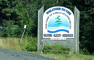
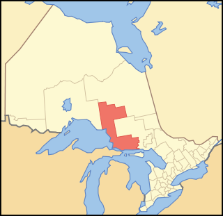
Sables-Spanish Rivers is a township in Ontario, Canada, on the north shore of Georgian Bay. It is located in the Sudbury District, approximately 70 kilometres (43 mi) west of Sudbury.

<span class="mw-page-title-main">Larder Lake, Ontario</span> Township in Ontario, Canada

Larder Lake is an incorporated municipal township and eponymous constituent dispersed rural community in Timiskaming District in Northeastern Ontario, Canada. It is located along Ontario Highway 66 and Ontario Highway 624 at the north-western part of the lake bearing the same name. The area of the township is 229.65 km2 (88.67 sq mi) and includes the geographic townships of Hearst, McVittie and Skead.

<span class="mw-page-title-main">Bancroft, Ontario</span> Town in Ontario, Canada

Bancroft is a town located on the York River in Hastings County in the Canadian province of Ontario. It was first settled in the 1850s by United Empire Loyalists and Irish immigrants. From the mid-1950s to about 1982, mining was the primary industry. A village until 1999, Bancroft then merged with Dungannon Township to form the Town of Bancroft. The population at the time of the 2016 Census was 3,881; the regional population is 40,000. There are 150,000 visitors to Bancroft, annually.

<span class="mw-page-title-main">Wawa, Ontario</span> Municipality in Ontario, Canada

Wawa is a township in the Canadian province of Ontario in the Algoma District. Formerly known as the Township of Michipicoten, named after a nearby river of that name, the township was officially renamed in 2007 for its largest and best-known community of Wawa, located on the western shores of Wawa Lake.

<span class="mw-page-title-main">Marmora and Lake</span> Municipality in Ontario, Canada

Marmora and Lake is a municipality along the banks of Crowe River and Beaver Creek, about midway between Toronto and Ottawa on provincial Highway 7 in Hastings County in Central Ontario, Canada. It is home to over 4,000 full time and seasonal residents, many of whom enjoy outdoor recreation and relaxation on Crowe Lake.

<span class="mw-page-title-main">South Frontenac</span> Township in Ontario, Canada

South Frontenac is a township in Frontenac County in eastern Ontario, Canada. It was amalgamated in 1998 from the former townships of Bedford, Loughborough, Portland, and Storrington.

<span class="mw-page-title-main">Nipissing, Ontario</span> Township in Ontario, Canada

Nipissing is an incorporated (political) township in Parry Sound District in Central Ontario, Canada. It is on Lake Nipissing and is part of the Almaguin Highlands region. Nipissing was surveyed between 1874 and 1881, and was incorporated in 1888. Among the first settlers in the area were the Chapman and Beatty families. Nipissing Township annexed Gurd Township in 1970. The township also contains a community named Nipissing, which is located on the South River near Chapman's Landing, on the South Bay of Lake Nipissing. The township administrative offices are located in Nipissing.

<span class="mw-page-title-main">Latchford, Ontario</span> Town in Ontario, Canada

Latchford is a single-tier municipality town in Timiskaming District in Northeastern Ontario, Canada. It is located on Bay Lake on the Montreal River, near the town of Cobalt and the municipality of Temagami, and is 20 kilometres from the city of Temiskaming Shores. The population of the town in the Canada 2011 Census was 387, which makes it the smallest town by population in Ontario. The town's slogan is "The Best Little Town by a Dam Site!"

<span class="mw-page-title-main">Fauquier-Strickland</span> Township in Ontario, Canada

Fauquier-Strickland is a township municipality in Cochrane District in Northeastern Ontario, Canada. The three main communities in the township are Fauquier, Strickland, and Gregoires Mill. All are located along Ontario Highway 11 between the community of Departure Lake to the east and the municipality of Moonbeam to the west.

<span class="mw-page-title-main">South Algonquin</span> Township municipality in Ontario, Canada

South Algonquin is a township municipality in Nipissing District, Ontario, Canada. Located south of Algonquin Provincial Park, it is the sole populated portion of the district that lies south of the traditional dividing line between Northern Ontario and Southern Ontario and is closer connected to Renfrew County as opposed to the core portions of Nipissing District.

<span class="mw-page-title-main">North Algona Wilberforce</span> Township municipality in Ontario, Canada

North Algona Wilberforce is a township municipality in Renfrew County, Ontario, Canada. It has a population of 2,873. The township was formed in 1999 when the North Algona and Wilberforce townships were amalgamated.

<span class="mw-page-title-main">Greater Madawaska</span> Township municipality in Ontario, Canada

Greater Madawaska is an incorporated township in Renfrew County in eastern Ontario, Canada, created on January 1, 2001, through the amalgamation of the Township of Bagot and Blythfield; the Township of Brougham; and the Township of Griffith and Matawatchan. As of 2011, it has a population of 2,518.

<span class="mw-page-title-main">Hudson, Ontario</span> Township in Ontario, Canada

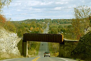
Hudson is a township municipality incorporating the congruent geographic township in Timiskaming District in northeastern Ontario, Canada. Hudson is located directly west of the city of Temiskaming Shores and has only one named settlement, the community of Hillview.

<span class="mw-page-title-main">Chamberlain, Ontario</span> Township in Ontario, Canada

Chamberlain is a township in the Canadian province of Ontario, located within the Timiskaming District.

<span class="mw-page-title-main">Charlton and Dack</span> Municipality in Ontario, Canada

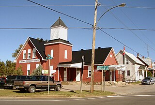
Charlton and Dack is a municipality in the Canadian province of Ontario, located within the Timiskaming District. Its population in 2016 was 686.

The Makobe River is a river in northeastern Ontario, Canada. It is in the Saint Lawrence River drainage basin, and is a left tributary of the Montreal River.

References

  1. 1 2 "James". Geographical Names Data Base . Natural Resources Canada . Retrieved 2017-01-03.
  2. 1 2 3 4 5 "Census Profile, 2016 Census: James, Township". Statistics Canada. 8 February 2017. Retrieved July 17, 2019.
  3. "James" (PDF). Geology Ontario - Historic Claim Maps. Ontario Ministry of Northern Development, Mines and Forestry. Archived from the original (PDF) on 2017-01-04. Retrieved 2017-01-03.
  4. "Elk Lake". Geographical Names Data Base . Natural Resources Canada . Retrieved 2017-01-03.
  5. Government of Canada, Statistics Canada (2022-02-09). "2021 Census of Population geographic summary: James, Township (TP) [Census subdivision], Ontario". www12.statcan.gc.ca. Retrieved 2023-11-13.
  6. "Indian Chute Generating Station". Ontario Power Generation.
  7. "History of Elk Lake". Archived from the original on 2021-05-11. Retrieved 2009-02-10.
  8. "Makobe-Grays River Provincial Park". Geographical Names Data Base . Natural Resources Canada . Retrieved 2017-01-03.
  9. "Makobe-Grays River". Ontario Parks . Retrieved 2017-01-03.
  10. "Population and dwelling counts: Canada, provinces and territories, census divisions and census subdivisions (municipalities), Ontario". Statistics Canada. February 9, 2022. Retrieved April 2, 2022.
  11. Statistics Canada: 1996, 2001, 2006, 2011 census
  12. 2011 Census Profile

Other map sources: