
Mammoth Cave National Park is a national park in south-central Kentucky, US. It encompasses portions of Mammoth Cave, the longest known cave system in the world. The park's 52,830 acres (21,380 ha) are located primarily in Edmonson County, with small areas extending eastward into Hart and Barren counties. The Green River runs through the park, with a tributary called the Nolin River feeding into the Green just inside the park.

Edmonson County is a county located in the south central portion of the U.S. state of Kentucky. As of the 2020 census, the population was 12,126. Its county seat and only municipality is Brownsville. The county was formed in 1825 and named for Captain John "Jack" Edmonson (1764–1813), who was killed at the Battle of Frenchtown during the War of 1812. This is a dry county where the sale of alcohol is prohibited. Edmonson County is included in the Bowling Green, Kentucky Metropolitan Statistical Area.

Barren County is a county located in the south-central portion of the U.S. state of Kentucky. As of the 2020 census, the population was 44,485. Its county seat is Glasgow. The county was founded on December 20, 1798, from parts of Warren and Green Counties. It was named for the Barrens, meadowlands that cover the northern third, though actually the soil is fertile. Barren County is part of the Glasgow, KY Micropolitan Statistical Area, which is also included in the Bowling Green-Glasgow, KY Combined Statistical Area. In 2007 Barren County was named the "Best Place to Live in Rural America" by Progressive Farmer Magazine.

An ice storm, also known as a glaze event or a silver storm, is a type of winter storm characterized by freezing rain. The U.S. National Weather Service defines an ice storm as a storm which results in the accumulation of at least 0.25-inch (6.4 mm) of ice on exposed surfaces. They are generally not violent storms but instead are commonly perceived as gentle rains occurring at temperatures just below freezing.

A winter storm is an event in which wind coincides with varieties of precipitation that only occur at freezing temperatures, such as snow, mixed snow and rain, or freezing rain. In temperate continental and subarctic climates, these storms are not necessarily restricted to the winter season, but may occur in the late autumn and early spring as well. A snowstorm with strong winds and other conditions meeting certain criteria is called a blizzard.
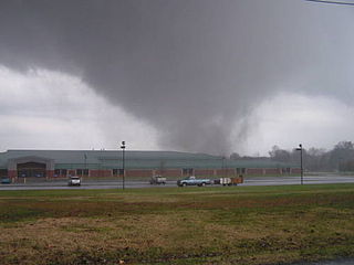
A destructive tornado outbreak impacted the Midwestern United States and Tennessee River Valley on November 15, 2005. It occurred along a cold front separating warm, humid air from the southeast from cold Arctic air to the north and northwest. 49 tornadoes were confirmed in the central United States in the states of Alabama, Arkansas, Illinois, Indiana, Kentucky, Missouri and Tennessee over that afternoon and evening. Strong winds and large hail caused additional damage throughout the region.
The January 2007 North American ice storm was a severe ice storm that affected a large swath of North America from the Rio Grande Valley to New England and southeastern Canada, starting on January 11 and lasting until January 16. It was followed by a second wave in the Southern United States from Texas to the Carolinas from January 16 through January 18, and a third one that hit the southern Plains and mid-Atlantic states as well as Newfoundland and Labrador from January 19 to January 24. It resulted in at least 74 deaths across 12 U.S. states and three Canadian provinces, and caused hundreds of thousands of residents across the U.S. and Canada to lose electric power.

Kentucky Route 70 (KY 70) is a long east-east state highway that originates at a junction with U.S. Route 60 (US 60) in Smithland in Livingston County, just east of the Ohio River. The route continues through the counties of Crittenden, Caldwell, Hopkins, Muhlenberg, Butler, Edmonson, Barren, Barren, Metcalfe, Green, Taylor, Casey, Pulaski, Lincoln and back into Pulaski again to terminate at a junction with US 150 near Maretburg in Rockcastle.

Hurricane Ike was a powerful tropical cyclone that swept through portions of the Greater Antilles and Northern America in September 2008, wreaking havoc on infrastructure and agriculture, particularly in Cuba and Texas. Ike took a similar track to the 1900 Galveston hurricane. The ninth tropical storm, fifth hurricane, and third major hurricane of the 2008 Atlantic hurricane season, Ike developed from a tropical wave west of Cape Verde on September 1 and strengthened to a peak intensity as a Category 4 hurricane over the open waters of the central Atlantic on September 4 as it tracked westward. Several fluctuations in strength occurred before Ike made landfall on eastern Cuba on September 8. The hurricane weakened prior to continuing into the Gulf of Mexico, but increased its intensity by the time of its final landfall in Galveston, Texas, on September 13 before becoming an extratropical storm on September 14. The remnants of Ike continued to track across the United States and into Canada, causing considerable damage inland, before dissipating on the next day.

The effects of Hurricane Ike in inland North America, in September 2008, were unusually intense and included widespread damage across all or parts of eleven states – Arkansas, Illinois, Indiana, Kentucky, Michigan, Missouri, New York, Ohio, Pennsylvania, Tennessee and West Virginia, and into parts of Ontario as Ike, which had rapidly become an extratropical cyclone, was enhanced by an adjacent frontal boundary and produced widespread winds with gusts to hurricane-force in several areas. In addition, significant flooding which was already underway due to heavy rain from the front to the north was worsened by rainfall brought on by Ike in parts of Missouri, Illinois and Indiana to the west of the center.
On February 10–11, 2009, a broad-scale damaging wind event and small tornado outbreak affected the Central and Eastern United States. During the two-day period, 14 tornadoes touched down in seven states. Oklahoma was struck by six tornadoes, the most of any state. The six tornadoes in Oklahoma also tied the record for the most tornadoes ever recorded in the state during the month of February, which would later be broken in 2023. The first day of the outbreak produced the most tornadoes; the second brought mainly high wind damage and rain or snow in most of the Northeast.

The 2011 Groundhog Day blizzard was a powerful and historic winter storm that affected large swaths of the United States and Canada from January 31 to February 2, 2011, especially on Groundhog Day. During the initial stages of the storm, some meteorologists predicted that the system would affect over 100 million people in the United States. The storm brought cold air, heavy snowfall, blowing snow, and mixed precipitation on a path from New Mexico and northern Texas to New England and Eastern Canada. The Chicago area saw 21.2 inches (54 cm) of snow and blizzard conditions, with winds of over 60 mph (100 km/h). With such continuous winds, the blizzard continued to the north and affected Eastern and Atlantic Canada. Blizzard conditions affected many other large cities along the storm's path, including Tulsa, Oklahoma City, Kansas City, St. Louis, Springfield, El Paso, Las Cruces, Des Moines, Milwaukee, Detroit, Indianapolis, Dayton, Cleveland, New York City, New York's Capital District, and Boston. Many other areas not normally used to extreme winter conditions, including Albuquerque, Dallas and Houston, experienced significant snowfall or ice accumulation. The central Illinois National Weather Service in Lincoln, Illinois, issued only their fourth blizzard warning in the forecast office's 16-year history. Snowfall amounts of 20 to 28 inches were forecast for much of Northern and Western Illinois.

The December 2013 North American storm complex was a significant storm complex that included many different types of severe weather, including a winter storm, a severe ice storm and a tornado outbreak that impacted the central and eastern portions of Canada, parts of the Central Great Plains, the Southern United States, and the northeastern United States from 20 to 23 December 2013. Formed in the South Central United States, the storm headed across the Great Plains towards Canada into Atlantic Canada and northeastern United States where the storm dissipated on 23 December 2013. The storm produced freezing rain and snow to the affected areas which caused massive damage to electric power transmission and trees. The storm resulted in 29 deaths, loss of power to over a million residents and over $200 million in damages. The storm produced similar conditions to the ice storm of 1998 which affected similar areas.

The 2016–17 North American winter was quite warm across North America in general, due in part to a weak La Niña that was expected to influence weather conditions across the continent. Several notable events occurred during the season, including a potent winter storm that affected the East Coast of the United States in early January, the second-largest winter tornado outbreak on record later that month, and an unusually warm February. In addition, towards the end of the season, a large cyclonic storm system that caused a large tornado outbreak, flooding, and a potent blizzard occurred in the Heartland of the country. However, the most notable event of the winter was a powerful blizzard that impacted the Northeast and New England in mid-March, towards the end of the season.

The January 2017 North American ice storm was a major ice storm that impacted the Great Plains, Pacific Northwest, and American Midwest. During the storm, multiple U.S. states declared states of emergency, and icy road conditions caused traffic incidents and fatalities. It was Named Winter Storm Jupiter by the weather channel. An outbreak of 11 tornadoes also struck Texas, injuring two.
Kyrock is a ghost town in Edmonson County in south central Kentucky, United States. The ghost town is located about 2.4 miles (3.9 km) east of Sweeden, or about 5 miles (8.0 km) north-northeast of the county seat of Brownsville. It was once a referred to as a “company town” along the Nolin River during much of the first half of the 20th century, but the industrial town was disincorporated in 1966, about nine years after the closure of the company that created the town.

The February 15–20, 2021 North American winter storm, also unofficially referred to as Winter Storm Viola, was a significant and widespread snow and ice storm across much of the United States, Northern Mexico, and Southern Canada. The system started out as a winter storm on the West Coast of the United States on February 15, later moving southeast into the Southern Plains and Deep South from February 16–17. It then moved into the Appalachian Mountains and Northeastern United States, before finally moving out to sea on February 20. The storm subsequently became a powerful low pressure system over the North Atlantic, before eventually dissipating on February 26.

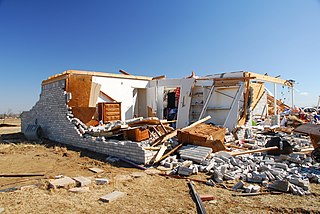
During the late evening of Friday, December 10, 2021, a violent, long-tracked EF4 tornado moved across Western Kentucky, producing severe to catastrophic damage in numerous towns, including Mayfield, Princeton, Dawson Springs, and Bremen. The second significant tornado in an exceedingly long-tracked tornado family, this tornado began just inside northern Obion County, Tennessee, a few miles after another long-tracked tornado – which traveled through northeast Arkansas, the Missouri Bootheel, and northwest Tennessee – dissipated in western Obion County. After crossing into Kentucky, the tornado moved through eleven counties of the Jackson Purchase and Western Coal Field regions while at times becoming wrapped in rain during its almost three-hour lifespan that covered 165.6 miles (266.5 km). It was the deadliest and longest-tracked tornado in an outbreak that produced numerous strong tornadoes in several states; 57 fatalities were confirmed in the tornado.

The February 2022 North American winter storm was a widespread, damaging, and severe winter storm which affected a wide swath of much of the United States with widespread wintry precipitation; it spread from Texas northeast to Maine. Nineteen states in the U.S. were impacted by the system; more than 90 million people were in the storm's path. The winter storm was named Winter Storm Landon by The Weather Channel and was also referred to by other media outlets as the Groundhog Snowstorm, primarily due to the storm impacting on Groundhog Day.

An ice storm impacted the Southern United States in early 2023, bringing heavy snow and ice across the region. The Weather Channel reported that at least 10 deaths were attributed to the winter storm, which was unofficially named Winter Storm Mara by them.


