Northeastern United States blizzard of 1978

Last updated

Northeastern United States blizzard of 1978
Category 5 "Extreme" (RSI/NOAA: 18.42)
Snow near City Hall (16374222425) (cropped).jpg
Type Blizzard
Extratropical cyclone
Ice storm
Winter storm
FormedFebruary 5, 1978 (1978-02-05)
DissipatedFebruary 7, 1978 (1978-02-07)
FatalitiesAround 100 fatalities; 4,500 injured
DamageUS$520 million
(US$2.43 billion in 2023 dollars)
Areas affected Northeastern United States
Scene on residential street in Woonsocket, Rhode Island Blizzardof78MapleSt.jpg
Scene on residential street in Woonsocket, Rhode Island

The Northeastern United States blizzard of 1978 [1] [2] was a catastrophic, historic nor'easter that struck New England, New Jersey, Pennsylvania, and the New York metropolitan area. The Blizzard of '78 formed on Sunday, February 5, 1978 and broke up on February 7. [3] The storm was initially known as "Storm Larry" in Connecticut, following the local convention promoted by the Travelers Weather Service on television and radio stations there. [4] Snow fell mostly from Monday morning, February 6 to the evening of Tuesday, February 7. Connecticut, Rhode Island, and Massachusetts were hit especially hard by this storm.

Contents

Boston received a record-breaking 27.1 inches (69 cm) of snow; Providence also broke a record with 27.6 inches (70 cm); [3] Atlantic City broke an all-time storm accumulation with 20.1 inches (51 cm); two Philadelphia suburban towns in Chester County received 20.2 inches (51 cm), while the City of Philadelphia received 16.0 inches (41 cm). [5] Nearly all economic activity was disrupted in the worst-hit areas. The storm killed about 100 people in the Northeast and injured about 4,500. [3] It caused more than US$520 million (US$2.43 billion in 2023 terms [6] ) in damage. [3]

Meteorological history

Car buried by snow in Boston Car in snow bank after blizzard (16348256826).jpg
Car buried by snow in Boston

The storm was formed from an extratropical cyclone off the coast of South Carolina on February 5. An Arctic cold front and a cold air mass then merged with the storm, creating the perfect ingredients for a large and intense low-pressure system. [3] [7]

This storm system made its way up the coast and approached southern New England late February 6 and early February 7. Since it developed during a new moon, an unusually large high tide occurred, and the storm brought a massive amount of water along coastal communities. [3] The huge storm surge resulted in broken sea walls and massive property loss. [3]

Strong winds and extremely heavy precipitation brought zero visibility for travelers, and numerous power outages ensued. The precipitation changed to rain on Cape Cod, reducing the total snowfall, but snow continued in the west. By the time it ended, thousands of people were stranded and homeless as a result of the storm. [3]

Storm strength

The storm's power was made apparent by its sustained hurricane-force winds of approximately 86 mph (138 km/h) with gusts to 111 mph (179 km/h) and the formation of an eye-like structure in the middle. [8] While a typical nor'easter brings steady snow for six to twelve hours, the Blizzard of '78 brought heavy snow for an unprecedented full 33 hours as it was blocked from heading into the North Atlantic by a strong Canadian high pressure area. [3] In many areas in Central and Southern New England, the snow falling at night turned to an icy mix that left a notable layer of solid ice on every external surface. This icy mixture greatly complicated recovery efforts in subsequent days, as it added considerable weight to power lines and tree limbs. Many trees that survived the daytime snow event did not survive the nighttime conditions.

An atypical vertical development of storm clouds brought unusual thundersnow to southern New England and Long Island. These storms resulted in lightning and thunder accompanying the snowfall as it fell at 4 inches (10 cm) an hour at times.

Effects

Conditions

One of the major problems with the Blizzard of 1978 was the lack of foreknowledge about the storm's severity. Weather forecasting in New England is difficult, and meteorologists had developed a reputation as being inaccurate. Forecasting techniques and technology had improved dramatically in the 1970s, but the public was still quite skeptical. Snow failed to arrive in Monday's pre-dawn hours as predicted, and many locals felt it to be another failed forecast—despite the accuracy of National Weather Service (NWS) forecasters' predictions concerning the Great Blizzard—and they went to work and school as normal. Because of this, people had neither time nor incentive to prepare. The region was already reeling after storms in January 1978 that left nearly two feet of snow in some areas of New England, [9] and had caused the collapse of the roof of the Hartford Civic Center. [10]

The government of Massachusetts had a system for notifying major employers to send employees home early in the event of heavy storms. Thousands of employees were sent home starting in the early afternoon of February 6, [11] but thousands more were still caught by the storm. Some did not make it home for several days. Many people were stranded in their cars along roads throughout New England. Fourteen people died on I-95 near Boston because snow piled high enough to prevent poisonous exhaust fumes from escaping from their idling vehicles. I-95 eventually had to be evacuated by cross-country skiers and snowmobilers. More than 3,500 cars were found abandoned and buried on roads during the cleanup. This number excludes the countless other vehicles buried in driveways, on the sides of streets, and in parking lots. Other transportation links were disrupted and shut down throughout the region, stranding public-transit commuters in city centers.

Snowplows were also stranded in traffic as the snow continued to fall. At one point on I-93 north of Boston, a jackknifed tractor trailer blocked traffic in both directions, with a similar event occurring on Route 128 near Route 138 in Canton. The Neponset River also flooded I-93 in Milton, causing the highway's complete closure.

A massive effort was made to clear Logan Airport runways for 200 National Guard troops' arrival on 27 C-130 and C-141 military flights from Fort Bragg and Fort Devens, who were called out by the governor.

Some 11,666 college-hockey fans in Boston Garden, then the site of the 26th edition of the annual "Beanpot" college ice hockey tournament, held at the time of the blizzard's outbreak, found weather much different from what they had expected. Some spectators spent the next few days living at the arena, eating hot dogs, and sleeping in the bleachers and locker rooms. [12] Because of the Blizzard, the second round of the Beanpot that year was not held until March 1, 1978, the latest date ever for the tournament's concluding games.

Throughout eastern Massachusetts, automobile traffic was banned for the remainder of the week. Thousands of people walked and skied on the quiet city streets and over the frozen Charles River.

This blizzard was one of the worst in Rhode Island's history, catching off guard many residents and the state government. Although Governor J. Joseph Garrahy had ordered an emergency evacuation of all public buildings, shortly before noon on February 6, too many people had lagged. Providence County, Rhode Island, was the hardest hit by the blizzard; the towns of Lincoln, Smithfield, Woonsocket, and North Smithfield all reported totals of at least 40 inches (100 cm) snow. [3]

In New York City, it was one of the rare times that a snowstorm closed the schools; the New York City Board of Education closed schools for snow again only once in the next 18 years, on April 7, 1982. [13] Most suburban districts in the area close for snow several times each winter, but they rarely do in the city itself because of relatively easy access to subways, whose ability to run is not appreciably affected by moderate snowstorms.[ citation needed ] The New York Knicks were also forced to postpone their first ever basketball game due to the airports being closed and the Portland Trail Blazers being unable to arrive in time. [14]

Many people were caught in the storm while driving, and many others were trapped in their homes and workplaces, with snow drifts of up to 15 feet (4.6 m), in some places blocking the exits. In many cases, those who had become ill or had been injured during the storm had to be taken to hospitals by snowmobile. Other people left their homes and went for help by cross-country skis and sleds.

The storm caused coastal flooding. The fierce northeast winds from the storm—with the low-pressure area stalled off the island of Martha's Vineyard—combined with high tides and storm surge, resulting from the storm's low pressure. This sent water over low land along the shores of Long Island Sound, Cape Cod Bay, and other bodies of water, causing some of the worst recorded coastal flooding. The flood continued through two days of tide cycles, a total of four successive high tides. Thousands of homes throughout coastal Massachusetts were damaged or destroyed, as was "Motif Number 1", in Rockport, an often-painted fisherman's shack renowned in art circles. [15] (A replica was constructed later the same year.) [16] The Peter Stuyvesant, [17] a former Hudson River Day Line boat turned into a floating restaurant, was sunk in Boston Harbor. The region's fishing fleet was damaged by the storm. [18]

Winds

The storm's straight-line surface winds destroyed buildings along the coast, often aided by flooding and waves. Wind gusts of 100 mph (160 km/h) were recorded in Plum Island and 110 mph (180 km/h) at First Cliff in Scituate, Massachusetts. [19] [20] Duxbury Beach was hit with 85 mph (137 km/h) gusts and 93 mph (150 km/h) in Chatham. [21] [22]

Aftermath and recovery

Boston and Providence recorded all-time highs for 24-hour and storm snowfall. [3] Many people were left without heat, water, food, and electricity for over a week after the storm finished. Approximately 10,000 people moved into emergency shelters. Some 2,500 houses were reported as seriously damaged or destroyed and 54 people were killed, many because of fallen electrical wires. Several people were found dead in downtown Providence, near the central police station; they may have been seeking shelter. Ten-year-old Peter Gosselin, of Uxbridge, Massachusetts, disappeared in the deep snow just feet from his home's front door and was not found until three weeks later. [23] [24] Most of the Interstate highway system in the region was shut down, with some stretches not reopening to traffic until the following week. Air and rail traffic also were shut down.

The snow fell too quickly for plow trucks to keep up. Plows were further hampered by the number of cars stuck on the roads. In Boston, the deep snow overwhelmed the city's sanitation department, because there was no more room along streets and sidewalks to put the snow; much of it was hauled to nearby harbors and dumped. Throughout the region, the high winds caused enormous drifts.

A state of emergency was declared by governors in the affected states, and the United States National Guard was called out to help clear the roads. Additional troops were flown into Boston to help. It took six days to clear the roads of snow and of the cars and trucks buried in it. Governor Ella T. Grasso ordered all roads in Connecticut closed except for emergency travel, for three days; [25] [26] Governor Michael Dukakis, of Massachusetts, did the same for his state. [27] The parking lot of Fenway Park was used for the National Guard to stage its efforts. In Massachusetts, there was no travel ban again until 35 years later, when Governor Deval Patrick announced a travel ban on February 8, 2013, running from 4 p.m. that day until 4 p.m. the next day, because of the February 2013 nor'easter, whose snowfall rivaled and, in some places, beat that of the Blizzard of '78; in the "Blizzard of '13", the ban was declared before the worst hit; in the Blizzard of '78 this happened after the storm's worst.

Extensive beach erosion occurred on the east coast of Massachusetts. Especially hard-hit were Cape Cod and Cape Ann, both on the eastern shore of Massachusetts. In Truro, on Cape Cod, the Atlantic Ocean broke through to the Pamet River for the first time during this storm, completely washing away the link between the North and South Pamet roads. The town chose not to reconstruct the link, though the right-of-way is open to pedestrians. Monomoy Island was split into north and south parts.

Many homes along the New England and Long Island coastlines were destroyed or washed into the ocean. Many roofs collapsed across New England from snow load. [28]

Related Research Articles

<span class="mw-page-title-main">Blizzard</span> Type of snowstorm

A blizzard is a severe snowstorm characterized by strong sustained winds and low visibility, lasting for a prolonged period of time—typically at least three or four hours. A ground blizzard is a weather condition where snow is not falling but loose snow on the ground is lifted and blown by strong winds. Blizzards can have an immense size and usually stretch to hundreds or thousands of kilometres.

<span class="mw-page-title-main">North American blizzard of 1996</span> Severe noreaster in January 1996

The North American blizzard of 1996 was a severe nor'easter that paralyzed the United States East Coast with up to 4 feet (1.2 m) of wind-driven snow from January 6 to January 8, 1996. The City University of New York reported that the storm "dropped 20 inches of snow, had wind gusts of 50 mph and snow drifts up to 8 feet high." This storm was a classic example of a nor'easter, but the storm would not have been as historically significant without the presence of the arctic high pressure system located to the north of New York. It was followed by another storm, an Alberta Clipper, on January 12, then unusually warm weather and torrential rain which caused rapid melting and river flooding in the Northeast Floods later that month. Along with the March Superstorm of 1993 and the January 2016 United States blizzard, it is one of only three snowstorms to receive the top rating of 5, or "Extreme", on the Northeast Snowfall Impact Scale (NESIS).

<span class="mw-page-title-main">North American blizzard of 2006</span> Winter storm in North America in 2006

The North American blizzard of 2006 was a nor'easter that began on the evening of February 11, 2006. It dumped heavy snow across the Mid-Atlantic and New England states, from Virginia to Maine through the early evening of February 12, and ended in Atlantic Canada on February 13. The major cities from Baltimore to Boston received at least a foot of snow, with a second-highest amount of 26.9 inches (68 cm) in New York City, the most since at least 1869, the start of record keeping, only broken by the January 2016 United States blizzard nearly 10 years later.

<span class="mw-page-title-main">1997 April Fool's Day blizzard</span>

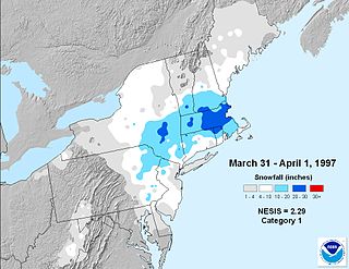
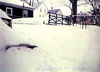
The 1997 April Fool's Day blizzard was a major winter storm in the Northeastern United States on March 31 and April 1, 1997. The storm dumped rain, sleet, and snow from Maryland to Maine leaving hundreds of thousands without power and as much as three feet of snow on the ground.

<span class="mw-page-title-main">February 9–10, 2010 North American blizzard</span> Severe weather event

The February 9–10, 2010 North American blizzard was a winter and severe weather event that afflicted the Midwest, Mid-Atlantic and New England regions of the United States between February 9–11, 2010, affecting some of the same regions that had experienced a historic Nor'easter just three days earlier. The storm brought 10 to 20 inches of snow across a wide swath from Washington, D.C., to New York City, with parts of the Baltimore metro area receiving more than 20 inches (51 cm). This storm began as a classic "Alberta clipper", starting out in Canada and then moving southeast, and finally curving northeast while rapidly intensifying off the New Jersey coast, forming an eye. The National Weather Service likened this storm to a Category 1 hurricane: "Winds topped 58 mph over part of the Chesapeake Bay, and 40 mph gusts were common across the region as the storm's center deepened and drifted slowly along the mid-Atlantic coast". The storm system, in conjunction with the earlier storm, has been nicknamed "Snoverkill."

<span class="mw-page-title-main">December 2010 North American blizzard</span> Blizzard

The December 2010 North American blizzard was a major nor'easter and historic blizzard affecting the Contiguous United States and portions of Canada from December 22–29, 2010. From January 4–15, the system was known as Windstorm Benjamin in Europe. It was the first significant winter storm of the 2010–11 North American winter storm season and the fifth North American blizzard of 2010. The storm system affected the northeast megalopolis, which includes major cities such as Norfolk, Pittsburgh, Philadelphia, Newark, New York City, Hartford, Providence, and Boston. It brought between 12 and 32 inches of snow in many of these areas.

<span class="mw-page-title-main">February 2013 North American blizzard</span> Noreaster in 2013

The February 2013 North American blizzard, also known as Winter Storm Nemo and the Blizzard of 2013, was a powerful blizzard that developed from the combination of two areas of low pressure, primarily affecting the Northeastern United States and parts of Canada, causing heavy snowfall and hurricane-force winds. The storm crossed the Atlantic Ocean, affecting Ireland and the United Kingdom. The nor'easter's effects in the United States received a Category 3 rank on the Northeast Snowfall Impact Scale, classifying it as a "Major" Winter Storm.

<span class="mw-page-title-main">March 2013 nor'easter</span>

The March 2013 nor'easter was a powerful nor'easter that affected much of the United States, most notably New England. On March 6, the system moved into the Mid-Atlantic region of the east coast, and intensified into a nor'easter, dumping up to 3 feet of snow in some places. By late March 6, 2013, the nor'easter had knocked out power to about 250,000 homes and businesses.

<span class="mw-page-title-main">January 2015 North American blizzard</span> 2015 snowstorm in eastern North America

The January 2015 North American blizzard was a powerful and severe blizzard that dumped up to 3 feet (910 mm) of snowfall in parts of New England. Originating from a disturbance just off the coast of the Northwestern United States on January 23, it initially produced a light swath of snow as it traveled southeastwards into the Midwest as an Alberta clipper on January 24–25. It gradually weakened as it moved eastwards towards the Atlantic Ocean, however, a new dominant low formed off the East Coast of the United States late on January 26, and rapidly deepened as it moved northeastwards towards southeastern New England, producing pronounced blizzard conditions. The nor’easter then gradually weakened as it moved away into Canada. The storm was also given unofficial names, such as Blizzard of 2015, and Winter Storm Juno.

<span class="mw-page-title-main">February 9–11, 2017 North American blizzard</span> Winter weather event

The February 9–11, 2017 North American blizzard was a fast-moving but powerful blizzard that affected the Northeastern United States with winter weather in the time span of February 8–9. Forming as an Alberta clipper in the northern United States, the system initially produced light snowfall from the Midwest to the Ohio Valley as it tracked southeastwards. It eventually reached the East Coast of the United States and began to rapidly grow into a powerful nor'easter. Up to 18 inches (46 cm) of snow as well as blizzard conditions were recorded in some of the hardest hit areas before the system moved away from the coastline early on February 10.

<span class="mw-page-title-main">March 2017 North American blizzard</span> North American blizzard in 2017

The March 2017 North American blizzard was a major late-season blizzard that affected the Northeastern United States, New England and Canada, dumping up to 3 feet of snow in the hardest hit areas, mainly New York, Vermont, New Hampshire and Southern Quebec. Forming out of an extratropical cyclone near the Northwest, the storm system dived into the northern portions of the United States, dropping light to moderate snow across the Great Lakes, Upper Midwest on March 11–12 before reaching the Ohio Valley the next day. It later coalesced into a powerful nor'easter off the East Coast, producing a swath of heavy snowfall across a large portion of the Northeast. The storm was given various unofficial names, such as Winter Storm Stella, Blizzard Eugene, and Blizzard of 2017.

<span class="mw-page-title-main">2017–18 North American winter</span> Weather summary

The 2017–18 North American winter saw weather patterns across North America that were very active, erratic, and protracted, especially near the end of the season, resulting in widespread snow and cold across the continent during the winter. Significant events included rare snowfall in the South, an outbreak of frigid temperatures that affected the United States during the final week of 2017 and early weeks of January, and a series of strong nor'easters that affected the Northeastern United States during the month of March. In addition, flooding also took place during the month of February in the Central United States. Finally the winter came to a conclusion with a powerful storm system that caused a tornado outbreak and blizzard in mid-April. The most intense event, however, was an extremely powerful cyclonic blizzard that impacted the Northeastern United States in the first week of 2018. Similar to the previous winter, a La Niña was expected to influence the winter weather across North America.

<span class="mw-page-title-main">January 2018 North American blizzard</span> Winter weather event

The January 2018 North American blizzard caused widespread severe disruption and blizzard conditions across much of the East Coasts of the United States and Canada in early January 2018. The storm dropped up to 2 feet of snow in the Mid-Atlantic states, New England, and Atlantic Canada, while areas as far south as southern Georgia and far northern Florida had brief wintry precipitation, with 0.1 inches of snow measured officially in Tallahassee, Florida. The storm originated on January 3 as an area of low pressure off the coast of the Southeast. Moving swiftly to the northeast, the storm explosively deepened while moving parallel to the Eastern Seaboard, causing significant snowfall accumulations. The storm received various unofficial names, such as Winter Storm Grayson, Blizzard of 2018 and Storm Brody. The storm was also dubbed a "historic bomb cyclone".

<span class="mw-page-title-main">2020–21 North American winter</span> Winter season in North America

The 2020–21 North American winter was the most significant winter season to affect North America in several years, and the costliest on record, with a damage total of at least $33.35 billion. The season featured 6 storms ranking on the Regional Snowfall Index scale (RSI), with 4 storms ranking as at least a Category 3. Most of the winter's damage and fatalities occurred due to a historic and major cold wave in mid-February. Several other significant events occurred, including a crippling early-season ice storm in the Southern Plains, a powerful nor'easter in mid-December, another major nor'easter in early February, two major and widespread winter storms in mid-February, and a major blizzard in the Rocky Mountains in mid-March. The winter-related events were responsible for at least 358 fatalities, making it the deadliest season since 1992–93. A La Niña pattern influenced much of the winter in North America.

<span class="mw-page-title-main">December 5–6, 2020 nor'easter</span> North American noreaster in 2020

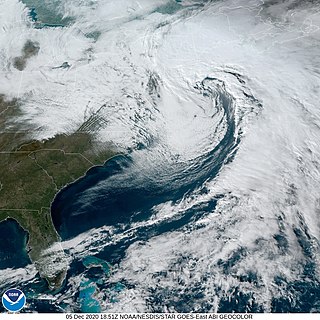
The December 5–6, 2020 nor'easter brought heavy snowfall, hurricane-force wind gusts, blizzard conditions, and coastal flooding to much of New England in the first few days of December 2020. The system originated on the Mid-Atlantic coast late on December 4. It then moved up the East Coast of the United States from December 5–6, bombing out and bringing heavy wet snow to the New England states. It brought up to 18 inches (46 cm) of snow in northern New England, with widespread totals of 6–12 inches (15–30 cm) farther south.

<span class="mw-page-title-main">December 15–17, 2020 nor'easter</span> North American noreaster in 2020

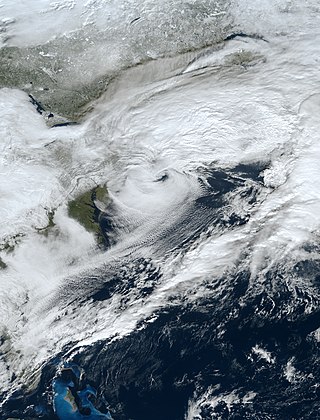
The December 15–17, 2020 nor'easter was a powerful nor'easter that hammered the Northeastern United States and produced widespread swaths of over 1 foot (12 in) of snow in much of the region from December 15–17, 2020, ending a 1,000+ day high-impact snowstorm drought in much of the Mid-Atlantic and coastal New England regions. The system developed out of a weak area of low-pressure that first developed over the Central United States producing some snowfall before moving eastward, and by December 16, a new, dominant area of low pressure began to develop along the Southeast coast. This low steadily deepened as it moved along and impacted the Mid-Atlantic coastline, prompting several winter-related advisories and warnings for much of the Northeast.

<span class="mw-page-title-main">January 31 – February 3, 2021 nor'easter</span>

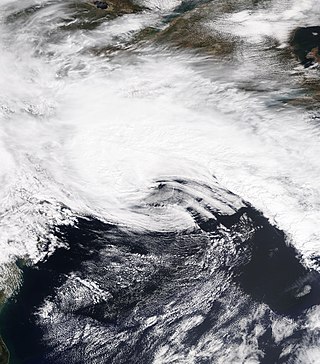
The January 31 – February 3, 2021 nor'easter, also known as the 2021 Groundhog Day nor'easter, was a powerful, severe, and erratic nor'easter that impacted much of the Northeastern United States and Eastern Canada from February 1–3 with heavy snowfall, blizzard conditions, strong gusty winds, storm surge, and coastal flooding. The storm first developed as an extratropical cyclone off the West Coast of the United States on January 25, with the storm sending a powerful atmospheric river into West Coast states such as California, where very heavy rainfall, snowfall, and strong wind gusts were recorded, causing several hundred thousand power outages and numerous mudslides. The system moved ashore several days later, moving into the Midwest and dropping several inches of snow across the region. On February 1, the system developed into a nor'easter off the coast of the Northeastern U.S., bringing prolific amounts of snowfall to the region. Large metropolitan areas such as Boston and New York City saw as much as 18–24 inches (46–61 cm) of snow accumulations from January 31 to February 2, making it the worst snowstorm to affect the megalopolis since the January 2016 blizzard. It was given the unofficial name Winter Storm Orlena by The Weather Channel.

<span class="mw-page-title-main">April 2021 nor'easter</span> Slow-moving noreaster in April 2021

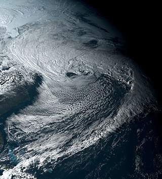
The April 2021 nor'easter, also referred to as the 2021 Spring nor'easter, was a significant late-season nor'easter that impacted much of New England with heavy snowfall, gusty winds, thundersnow, and near-whiteout conditions from April 15–17, 2021. The system originated from a weak frontal system late on April 14 over North Carolina, which moved into the ocean the next day and began to strengthen. The low-pressure steadily deepened as it moved up the East Coast, and developed an eye-like feature just prior to peak intensity. It prompted a fairly large area of Winter Storm Warnings across interior sections of New England, with Winter Weather Advisories being issued closer to the coast. Over 20,000 customers lost power at the height of the storm on April 16 due to heavy wet snow, and near-whiteout conditions were reported in many areas. Several injuries, some serious, occurred as well, mostly due to traffic incidents on poorly-treated roadways during the storm. Damage estimates from the system are currently not calculated.

<span class="mw-page-title-main">January 2022 North American blizzard</span> North American blizzard in 2022

The January 2022 North American blizzard caused widespread and disruptive impacts to the Atlantic coast of North America from northern Delaware to Nova Scotia with as much as 2.5 feet (30 in) of snowfall, blizzard conditions and coastal flooding at the end of January 2022. Forming from the energy of a strong mid- to upper-level trough, the system developed into a low-pressure area off the Southeast United States on January 28. The system then quickly intensified that night as it traveled northeast parallel to the coast on January 29, bringing heavy snowfall blown by high winds to the upper East Coast of the continent. Further north, it also moved inland in Maine and its width meant it strongly impacted all three of Canada's Maritime provinces. In some areas, mainly the coastal regions due to the wind, areas of New Jersey, Long Island and Massachusetts, it was the first blizzard since a storm in January 2018. The storm was considered a "bomb cyclone" as it rapidly intensified and barometric pressure dropped at least 24 millibars over a 24-hour period. The storm was given names such as Blizzard of 2022 and Winter Storm Kenan.

<span class="mw-page-title-main">March 11–15, 2018 nor'easter</span> North American winter storm in 2018

A winter storm, unofficially named Winter Storm Skylar by The Weather Channel, brought widespread blizzard conditions across the Northeastern United States, particularly New England in mid-March 2018. First impacting the Midwestern and Southern United States on March 11–12, causing travel impacts and producing high snowfall totals, the winter storm then moved into the Northeastern United States and became a nor'easter, producing blizzard conditions and heavy snowfall across portions of the interior Northeast on March 13–15. Heavy snow fell in Massachusetts, where most of the state received at least one foot of snow; the storm brought the heaviest March snow on record in Boston and Worcester. Over two feet of snow were reported in portions of Massachusetts, peaking at 31 inches (79 cm) in Wilmington. Heavy snow also fell in Rhode Island, where the snowfall peaked at 25.1 inches (64 cm) in Foster.

References

  1. "The Blizzard of 1978: The week the state stood still". Quahog.org. Retrieved February 29, 2012.
  2. "The Blizzard of 1978: Seacoast SAD, February 15, 1978". Hampton.lib.nh.us. February 15, 1978. Retrieved February 29, 2012.
  3. 1 2 3 4 5 6 7 8 9 10 11 "NWS Boston Page of the 1978 blizzard". Erh.noaa.gov. Retrieved February 29, 2012.
  4. Purmont, Jon E. (January 2013). Ella Grasso: Connecticut's Pioneering Governor. p. 204. ISBN   9780819573445 via Google Books.
  5. Mucha, Peter (February 14, 2014). "Historic Philly snowfalls: Suburbs' totals dominate". www.inquirer.com.
  6. 1634–1699: McCusker, J. J. (1997). How Much Is That in Real Money? A Historical Price Index for Use as a Deflator of Money Values in the Economy of the United States: Addenda et Corrigenda (PDF). American Antiquarian Society. 1700–1799: McCusker, J. J. (1992). How Much Is That in Real Money? A Historical Price Index for Use as a Deflator of Money Values in the Economy of the United States (PDF). American Antiquarian Society. 1800–present: Federal Reserve Bank of Minneapolis. "Consumer Price Index (estimate) 1800–" . Retrieved February 29, 2024.
  7. David Epstein (February 6, 2013). "The meteorology behind the blizzard of February 6-7, 1978". The Boston Globe .
  8. "The Northeast Blizzard Of 1978". Hurricanes-blizzards-noreasters.com. Retrieved February 29, 2012.
  9. "The Blizzard of '78... Revisited" National Weather Service.
  10. "#ThrowbackThursday: Hartford Civic Center Roof Collapse". courant.com.
  11. "A look back at the Blizzard of 1978". The Boston Globe . January 31, 2008.
  12. "The Blizzard of '78". Archived from the original on February 12, 2013. Retrieved February 9, 2013.
  13. The 11 Snowstorms That Closed NYC Schools, AnimalNewYork, February 11, 2014
  14. Knicks’ Game Postponed; Many Fans Are Angered By Confusion on Decision, New York Times, February 8, 1978
  15. "A look back at the Blizzard of 1978". Boston.com
  16. Harris, Patricia and Lyon, David. (2006). You Know You're in Massachusetts When...: 101 Quintessential Places, People, Events, Customs, Lingo, and Eats of the Bay State. Globe Pequot. ISBN   0-7627-4132-5
  17. "A look back at the Blizzard of 1978". Boston.com.
  18. Fahey, Rich (February 7, 2008). "A blizzard too furious to forget". The Boston Globe.
  19. "The Blizzard of '78". Matt Bowling. Retrieved June 10, 2016.
  20. "Blizzard of 78 - stories outside of Hull, MA". Bruce Simons. Retrieved June 10, 2016.
  21. "Remembering the Blizzard of '78". WeatherWorks, Inc. Retrieved June 10, 2016.
  22. Del Santo, T.J. (February 5, 2013). "Blizzard of 1978, 35 Years Later". WPRI Eyewitness News. Archived from the original on October 9, 2016. Retrieved June 11, 2016.
  23. "A defining event in R.I. history". Providence Journal (Projo.com). February 7, 2012. Archived from the original on June 29, 2011. Retrieved February 29, 2012.
  24. "Body of Boy Found as Snow Melts". The Hour. March 1, 1978. Retrieved February 8, 2013.
  25. "Grasso Closes the State" by proclamation". Connecticut State Library. Archived from the original on February 6, 2013. Retrieved February 6, 2013.
  26. "Blizzard Of 1978: Feb. 6-7, 1978: The Blizzard Of '78 Shut Down The State And Made Heroes Out Of Those With Four-Wheel Drive". Hartford Courant . Retrieved February 6, 2013.
  27. Boston Herald American, February 10, 1978
  28. "Hartford Civic Center Arena Roof Collapse". Eng.uab.edu. Archived from the original on January 8, 2008. Retrieved February 29, 2012.

Further reading