
The Virgin Islands National Park is an American national park preserving about 60% of the land area of Saint John in the United States Virgin Islands, as well as more than 5,500 acres of adjacent ocean, and nearly all of Hassel Island, just off the Charlotte Amalie, Saint Thomas harbor.

Saint John is one of the Virgin Islands in the Caribbean Sea and a constituent district of the United States Virgin Islands (USVI), an unincorporated territory of the United States.

Cruz Bay, U.S. Virgin Islands is the main town on the island of Saint John in the United States Virgin Islands. According to the 2000 census, Cruz Bay had a population of 2,743.

Salt River Bay National Historic Park and Ecological Preserve is a unit of the National Park Service on the island of St. Croix in the U.S. Virgin Islands. It preserves upland watersheds, mangrove forests, and estuarine and marine environments that support threatened and endangered species. It also contains the Columbus Landing Site, a National Historic Landmark that is the only known site where members of a Columbus expedition set foot on what is now United States territory. The site is marked by Fort Salé, a remaining earthworks fortification from the French period of occupation, about 1617. The park also preserves prehistoric and colonial-era archeological sites including the only existing example of a ball court in the US Virgin Islands.

Fort Frederik, also known as Frederiksfort, is a U.S. National Historic Landmark in Frederiksted, United States Virgin Islands. It was built between 1752 and 1760 by Denmark-Norway to defend the economic interests of the natural deep water port of Frederiksted and to ward off pirates. It has red and white painted walls, making it quite different then yellow and white of Fort Christiansværn on the other side of the island. It is located at the north end of Frederiksted, in St. Croix, south of the junction of Mahogany Road and VI 631. It should not be confused with Frederiks Fort, Fortberg Hill, on St. John, which is also listed on the National Register of Historic Places.

Cinnamon Bay Plantation is an approximately 300-acre (1.2 km2) property situated on the north central coast of Saint John in the United States Virgin Islands adjacent to Cinnamon Bay. The land, part of Virgin Islands National Park, was added to the United States National Register of Historic Places on July 11, 1978. Archaeological excavations of the land document ceremonial activity of the Taínos, as well as historic remains of plantation ruins.

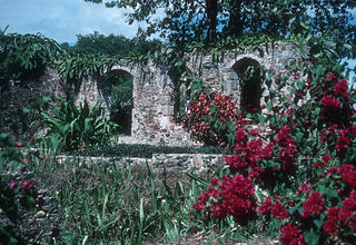
Reef Bay Sugar Factory Historic District is a historic section of Saint John, United States Virgin Islands located on the south central coast adjacent to Reef Bay. The land is the site of a sugar factory. The property was added to the U.S. National Register of Historic Places on July 23, 1981.

The Reef Bay Trail petroglyphs are a group of Taíno petroglyph carvings found in the Virgin Islands National Park on the island of St. John, United States Virgin Islands. They are located in a part of the park called the Reef Bay Trail.

The Charlotte Amalie Historic District in Charlotte Amalie in Saint Thomas, U.S. Virgin Islands is a 165.3 acres (0.669 km2) historic district which was listed on the National Register of Historic Places in 1976.

The Christiansted Historic District is a 135.9 acres (0.550 km2) historic district in Christiansted, Saint Croix, Virgin Islands, which was listed on the National Register of Historic Places in 1976. It included 253 contributing buildings and two contributing sites.
Estate Saint George Historic District is a historic district in the Northwest subdistrict near Fredericksted in Saint Croix, U.S. Virgin Islands which was listed on the National Register of Historic Places in 1986. The listing included eight contributing buildings, nine contributing sites, and seven contributing structures.

The Estate Carolina Sugar Plantation near Coral Bay on Saint John, U.S. Virgin Islands is a historic sugar plantation and later rum distillery.

Brown Bay is a bay and a former sugar cane and cotton plantation in the Virgin Islands National Park on the island of Saint John, U.S. Virgin Islands. It is on the north shore of eastern end of the island, north of the settlement of Palestina.
Liever Marches Bay is a shallow bight on the north shore of the island of St. John, U.S. Virgin Islands, just east of Brown Bay, towards the eastern end of the island. It has a 450 feet (140 m) shingle beach.
The L'Esperance Historic District, located east of Cruz Bay off Center Line Rd., on Saint Thomas in the U.S. Virgin Islands, is a historic district which was listed on the National Register of Historic Places in 1981. It is located within Virgin Islands National Park. The listing included two contributing structures and nine contributing sites on 6.3 acres (2.5 ha).
Slob Historic District, near Christiansted, Virgin Islands, is a historic district which was listed on the National Register of Historic Places in 1987. The listing included nine contributing buildings, three contributing structures, and a contributing site on 9 acres (3.6 ha).
Hans Hendrik Berg or Hans Henrik Berg (1789-1862) was Governor of St. Thomas, St. John in 1848 and again in 1853–1862, in the Danish West Indies.

Estate St. John, near Christiansted on Saint Croix in the United States Virgin Islands, was listed on the National Register of Historic Places in 1978. It has also been known as St. Jan Plantage. The listing included two contributing buildings and a contributing structure.

Estate Butler's Bay, on the island of Saint Croix in the U.S. Virgin Islands, was established as a sugar plantation by 1764. It was listed on the National Register of Historic Places in 1978. The listing included five contributing buildings, a contributing structure, and five contributing sites.

