
The United States Virgin Islands, officially the Virgin Islands of the United States, are a group of Caribbean islands and an unincorporated and organized territory of the United States. The islands are geographically part of the Virgin Islands archipelago and are located in the Leeward Islands of the Lesser Antilles to the east of Puerto Rico and west of the British Virgin Islands.
The Danish West Indies or Danish Antilles or Danish Virgin Islands were a Danish colony in the Caribbean, consisting of the islands of Saint Thomas with 32 square miles (83 km2); Saint John with 19 square miles (49 km2); and Saint Croix with 84 square miles (220 km2). The islands have belonged to the United States since they were purchased in 1917. Water Island was part of the Danish West Indies until 1905, when the Danish state sold it to the East Asiatic Company, a private shipping company.

Saint Croix is an island in the Caribbean Sea, and a county and constituent district of the United States Virgin Islands (USVI), an unincorporated territory of the United States.

The Virgin Islands National Park is an American national park preserving about 60% of the land area of Saint John in the United States Virgin Islands, as well as more than 5,500 acres of adjacent ocean, and nearly all of Hassel Island, just off the Charlotte Amalie, Saint Thomas harbor.

Saint John is one of the Virgin Islands in the Caribbean Sea and a constituent district of the United States Virgin Islands (USVI), an unincorporated territory of the United States.

Cinnamon Bay is a body of water and a beach on St. John island, within Virgin Islands National Park, in the United States Virgin Islands.

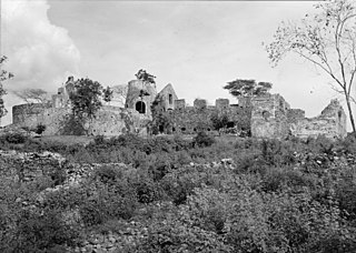
Mount Healthy windmill is a ruined windmill on the north side of Tortola in the British Virgin Islands. It was formerly used during the plantation era of the Territory to crush sugar cane. After the collapse of the sugar economy in the early nineteenth century the windmill fell into disuse and became a ruin. It crushed cane for the sugar mill and rum distillery in nearby Brewer's Bay. There are other ruins like the Boiling House, remnants of the Animal Mill Round, distillery, hospital, storage, shed, and housing. The 18th century windmill belonged to the area's wealthiest planter. Slaves harvested and processed sugar cane into sugar at this extensive sugarcane plantation.

Gibney Beach is a stretch of white sandy beach located on Hawksnest Bay on St John Island in the United States Virgin Islands. There is vibrant wildlife both on the beach and in the bay. The colonial history, the natives, the beatnik and hippie movements, and the locals of the island come together to form the original, bohemian character of the beach.

Betty's Hope was a sugarcane plantation in Antigua. It was established in 1650, shortly after the island had become an English colony, and flourished as a successful agricultural industrial enterprise during the centuries of slavery. It was the first large-scale sugar plantation to operate in Antigua and belonged to the Codrington family from 1674 until 1944. Christopher Codrington, later Captain General of the Leeward Islands, acquired the property in 1674 and named it Betty's Hope, after his daughter.

Catherineberg Sugar Mill Ruins is an historic site located in the Virgin Islands National Park, east of Cruz Bay on Saint John, U.S. Virgin Islands. The ruins are an example of an 18th-century sugar and rum factory.

Cinnamon Bay Plantation is an approximately 300-acre (1.2 km2) property situated on the north central coast of Saint John in the United States Virgin Islands adjacent to Cinnamon Bay. The land, part of Virgin Islands National Park, was added to the United States National Register of Historic Places on July 11, 1978. Archaeological excavations of the land document ceremonial activity of the Taínos, as well as historic remains of plantation ruins.
Annaberg Historic District is a historic section of Saint John, United States Virgin Islands where the Annaberg sugar plantation ruins are located. The district is located on the north shore of the island west of Mary's Point in the Maho Bay quarter.

Mary Point Estate is a historic property located on the north coast of Saint John, United States Virgin Islands on Mary's Point. The plantation was added to the U.S. National Register of Historic Places on May 22, 1978.

Bethlehem Old Work is a settlement on the island of Saint Croix in the United States Virgin Islands. It was set-up as one of the first plantations in the 1730s, and operated as the last sugar plantation on the island until the Bethlehem Central Factory closed in 1966.

Sugar production in the United States Virgin Islands was an important part of the economy of the United States Virgin Islands for over two hundred years. Long before the islands became part of the United States in 1917, the islands, particular the island of Saint Croix, was exploited by the Danish from the early 18th century and by 1800 over 30,000 acres were under cultivation, earning Saint Croix a reputation as the "Garden of the West Indies". Since the closing of the last sugar factory on Saint Croix in 1966, the industry has become only a memory.
Sion Hill is a settlement on the island of Saint Croix, in the United States Virgin Islands.

Estate Little Princess is a historic plantation site located northwest of Christiansted in Saint Croix, U.S. Virgin Islands. It was first owned by governor Frederik Moth in 1738 and rests on 25 acres of land. As of 2011 the estate is under ownership of The Nature Conservancy and serves as headquarters for the Eastern Caribbean/Virgin Islands programs. The property has been turned into a nature preserve and historical tours are given as well. The site was listed on the National Register of Historic Places on June 9, 1980.

The Estate Carolina Sugar Plantation near Coral Bay on Saint John, U.S. Virgin Islands is a historic sugar plantation and later rum distillery.

Whim is a historic sugar plantation located in Southwest subdistrict about 1.7 miles (2.7 km) southeast of Frederiksted on Centerline Road on Saint Croix, U.S. Virgin Islands. It was listed on the National Register of Historic Places in 1976. The listing included three contributing buildings, one contributing site, and two contributing structures, on 10 acres (4.0 ha).
Mosquito Bay plantation was owned by Johan Lorentz Carstens, who was also the owner of the plantations Perlen on Saint Thomas, U.S. Virgin Islands and a smaller plantation on St. Jan.


