
Colonial National Historical Park is located in the Hampton Roads region of Virginia and is operated by the National Park Service of the United States government. The park protects and interprets several sites relating to the Colony of Virginia and the history of the United States more broadly, ranging from the site of the first landing of the English settlers who would settle at Jamestown, to the battlefields of Yorktown where the British Army was finally defeated in the American Revolutionary War. Over 3 million people visit the park each year.

The Virgin Islands National Park is an American national park preserving about 60% of the land area of Saint John in the United States Virgin Islands, as well as more than 5,500 acres of adjacent ocean, and nearly all of Hassel Island, just off the Charlotte Amalie, Saint Thomas harbor.

Ocmulgee Mounds National Historical Park in Macon, Georgia, United States preserves traces of over ten millennia of culture from the Native Americans in the Southeastern Woodlands. Its chief remains are major earthworks built before 1000 CE by the South Appalachian Mississippian culture These include the Great Temple and other ceremonial mounds, a burial mound, and defensive trenches. They represented highly skilled engineering techniques and soil knowledge, and the organization of many laborers. The site has evidence of "17,000 years of continuous human habitation." The 3,336-acre (13.50 km2) park is located on the east bank of the Ocmulgee River. Macon, Georgia developed around the site after the United States built Fort Benjamin Hawkins nearby in 1806 to support trading with Native Americans.

Coral Bay is a town and a sub-district on the island of St. John in the United States Virgin Islands. It is located on the southeastern side of the island. It was the commercial center of the island in the 19th century as the site of the largest plantation, but from the 1950s onward the population dwindled as the Cruz Bay side of the island with its airport and ferry service to St. Thomas became the gateway to the Virgin Islands National Park. Today Coral Bay is a thriving small community with small outdoor restaurants, grocery stores, businesses and tourism services.

Staunton River State Park is a state park in Virginia. One of the Commonwealth's original state parks, built by the Civilian Conservation Corps and opening in 1936, it is located along the Staunton River near Scottsburg, Virginia. It is an International Dark Sky Park.

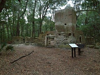
Catherineberg Sugar Mill Ruins is an historic site located in the Virgin Islands National Park, east of Cruz Bay on Saint John, U.S. Virgin Islands. The ruins are an example of an 18th-century sugar and rum factory.

Cinnamon Bay Plantation is an approximately 300-acre (1.2 km2) property situated on the north central coast of Saint John in the United States Virgin Islands adjacent to Cinnamon Bay. The land, part of Virgin Islands National Park, was added to the United States National Register of Historic Places on July 11, 1978. Archaeological excavations of the land document ceremonial activity of the Taínos, as well as historic remains of plantation ruins.

Reef Bay Sugar Factory Historic District is a historic section of Saint John, United States Virgin Islands located on the south central coast adjacent to Reef Bay. The land is the site of a sugar factory. The property was added to the U.S. National Register of Historic Places on July 23, 1981.

Rose Hill Plantation State Historic Site is a historic site in Union County, South Carolina, that preserves the home of William H. Gist (1807-1874), the 68th governor of South Carolina. Gist helped instigate a Secession Convention in South Carolina, which led to the creation of the Ordinance of Secession that preceded the Civil War.

Green Kay is a settlement on the island of Saint Croix in the United States Virgin Islands. It is located 3.3 miles (5.3 km) east of Christiansted.
Stoney-Baynard Plantation on Hilton Head Island, SC was listed on the National Register of Historic Places in 1994. The listing included one contributing site on 6 acres (2.4 ha).

The Walnut Hill Historic District is a collection of 40 family dwellings, agricultural outbuildings, and other structures and sites associated with the Walnut Hill Plantation and the Mial-Williamson and Joseph Blake farms near Shotwell, North Carolina. The historic district represents the post-Civil War growth of one of the largest agricultural centers in Wake County. It is situated primarily along the northeast end of Mial Plantation Road between its intersections with Major Slade and Smithfield Roads.

The Bethlehem Middle Works Historic District, in King's Quarter, in Southcentral, in Saint Croix, U.S. Virgin Islands, was listed on the National Register of Historic Places in 1988. It is also known as Estate Bethlehem Middle Works and as Bethlehem Middle Works. It is a 34 acres (14 ha) historic district which included 26 contributing buildings, two contributing structures, and four contributing sites.

Estate Hogansborg is located east of Frederiksted off Centerline Road in the Northwest district of Saint Croix, U.S. Virgin Islands, or the West End Quarter of Saint Croix. It dates back to 1757. It was listed on the U.S. National Register of Historic Places in 1978. The listing included four contributing buildings, two contributing structures, and three contributing sites on 4.6 acres (1.9 ha).
Brown Bay is a bay and a former sugar cane and cotton plantation in the Virgin Islands National Park on the island of Saint John, U.S. Virgin Islands. It is on the north shore of eastern end of the island, north of the settlement of Palestina.
Liever Marches Bay is a shallow bight on the north shore of the island of St. John, U.S. Virgin Islands, just east of Brown Bay, towards the eastern end of the island. It has a 450 feet (140 m) shingle beach.
The L'Esperance Historic District, located east of Cruz Bay off Center Line Rd., on Saint Thomas in the U.S. Virgin Islands, is a historic district which was listed on the National Register of Historic Places in 1981. It is located within Virgin Islands National Park. The listing included two contributing structures and nine contributing sites on 6.3 acres (2.5 ha).
Slob Historic District, near Christiansted, Virgin Islands, is a historic district which was listed on the National Register of Historic Places in 1987. The listing included nine contributing buildings, three contributing structures, and a contributing site on 9 acres (3.6 ha).
The Jossie Gut Historic District, in Reef Bay Valley / Reef Bay, Virgin Islands, was listed on the National Register of Historic Places in 1981. The listing included two contributing structures and four contributing sites. It is included in Virgin Islands National Park. It is located west of Coral Bay off Center Line Road, in the Central area of the park. It includes remains of a horsemill.

