Kapuas Hulu Regency

Last updated
Kapuas Hulu Regency
A road in Putussibau.jpg
A road section in Putussibau
Lambang Kabupaten Kapuas Hulu.jpg
Locator map of Kapuas Hulu Regency in West Kalimantan.svg
Location within West Kalimantan
Indonesia Kalimantan location map.svg
Red pog.svg
Kapuas Hulu Regency
Location in Kalimantan and Indonesia
Indonesia location map.svg
Red pog.svg
Kapuas Hulu Regency
Kapuas Hulu Regency (Indonesia)
Coordinates: 0°49′00″N112°46′00″E / 0.8167°N 112.7667°E / 0.8167; 112.7667
Country Indonesia
Province West Kalimantan
Regency seat Putussibau
Government
  RegentA.M. Nasir
  Vice RegentAntonius L. Ain Pamero
Area
  Total29,842.03 km2 (11,522.07 sq mi)
Population
 (mid 2022 estimate) [1]
  Total254,995
  Density8.5/km2 (22/sq mi)
Time zone UTC+7 (IWST)
Area code (+62) 567
HDI (2020)Increase2.svg 0.657 (Medium) [2]
Website kapuashulukab.go.id

Kapuas Hulu Regency is a regency in West Kalimantan province of Indonesia. Located around Kapuas River, it has a total area of 29,842.03 square kilometres or around 20.26% of West Kalimantan province's area. The regency seat is located in town of Putussibau, where most of its economic and government activities take place. Due to its relatively large area, it is sparsely populated compared to neighbouring regencies around it. [3] The regency had a population of 222,160 at the 2010 Census [4] and 252,609 according to the 2020 Census; [5] the official estimate as at mid 2022 was 254,995. [1]

Contents

History

The area was under kingdom of Selimbau, which was under influence of Sultanate of Sambas in early 17th and 18th century. Other than it, there were several smaller kingdoms and Malay chieftains such as Suhai, Jongkong, and Bunut, scattered around the region. [6]

On 1823, Dutch settlers began exploring the region and Dutch colonial government signed a treaty with kingdom of Selimbau, acknowledging its domination over smaller kingdoms and chieftains in the region. Over time, the kingdom gradually lost its autonomy and the last king of Selimbau, Haji Gusti Usman, abdicated on 1925. The region was incorporated into Dutch East Indies and administrated from Sintang. [7]

During Japanese occupation of Dutch East Indies, the region was administrated by Imperial Japanese Navy from Banjarmasin. Japanese opened a coal mine around Mentabah and Tebaung river in 1942 to support their war effort on Pacific. The locals welcomed Japanese at first, thought them to be liberator from Dutch rule. However, due to exploitation and treatment on locals, they turned against the Japanese later on. It was estimated around 1,000 native worked as Rōmusha died in the region during Japanese occupation. [7] [8] The occupation resulted in Majang Desa War or more popularly known as Dayak Desa War, with Japanese expelled from Borneo interior as the result. [8] [9] One of leader's war and Dayak chieftain, nicknamed Pang Suma, today is regarded as hero not only in the region but also Indonesia in general. [10] [11] The region became an autonomous royal region within West Kalimantan in 1946 and later became a regency under Law Number 3 of 1953. [7]

There has been ongoing discussion about forming a new province, Kapuas Raya, which would include Kapuas Hulu as part of it, to be separated from West Kalimantan. [12] However, due to a moratorium on new administrative division creations for financial reason during COVID-19 pandemic, its creation has been put on halt by the Indonesian government. [13] [14]

Geography

The regency borders Sarawak in the north, Sintang Regency in the west and south, and East Kalimantan as well as Central Kalimantan in the east. Soil formation in the region is considered to be one of the oldest in Indonesian archipelago. There are numerous lakes, swamps, and wetlands in the region and lower region is often submerged by water from nearby rivers as long as six months a year. Settlements are mostly located around rivers due to historical importance of inland waterways in the past. There are 925,134 hectares of national park, 834.140 hectares of protected forest, and 769,000 hectares of production forest. [3]

The regency has tropical climate with temperature between 22.9 and 33.5 Celsius, with 84.6% air humidity, and 38% sunlight intensity. The wettest month is May with average rainfall of 547.66 mm3, and the driest is August with average 222.2 mm3. [3]

Governance

Administrative districts

At the time of the 2010 Census, the regency was divided into 25 administrative districts (kecamatan). However this has since been reduced to 23 by the amalgamation of the former Danau Sentarum District into Selimbau District, and the amalgamation of the former Hulu Kapuas District into Putussibau Selatan District. The regency seat, Putussibau, consists of the urban parts of two districts, which are North Putussibau and South Putussibau; both form the first and second most populous districts in the regency. Due to regency seat not having clear official boundaries, the estimated population of the town could be as high as 50,000 people depending on where the speculative border is drawn; but both districts include extensive rural regions. Below is a list of the districts with their areas and their populations according the 2010 [4] and 2020 [5] Censuses, as well as the official estimates as at mid 2021. [15] The table also includes the locations of the district administrative centres and the number of administrative villages (rural desa and urban kelurahan) in each district.

Name of
District
(kecamatan)
Area
in km2
Pop'n
2010
Census
Pop'n
2020
Census
Pop'n
mid 2021
Estimate
Admin
centre
No.
of
villages
Silat Hilir1,167.1016,98719,79119,910Nanga Silat13
Silat Hulu1,061.8010,73511,39511,360Nanga Dangkan14
Hulu Gurung431.9012,33913,91413,950Nanga Tepuai15
Bunut Hulu1,118.1412,88914,58814,640Nanga Suruk15
Mentebah771.268,90510,75410,860Nanga Mentebah8
Bika392.164,2284,6014,600Bika8
Kalis1,853.8411,76413,57813,650Nanga Kalis17
South Putussibau5,352.3318,718
(a)
23,11223,380Kedamin16
Embaloh Hilir784.305,3695,8305,830Nanga Embaloh9
Bunut Hilir882.108,4348,5548,490Nanga Bunut11
Boyan Tanjung822.0010,28312,57312,710Boyan Tanjung16
Pengkadan531.207,9599,4549,530Menendang11
Jongkong442.509,90710,86810,870Jongkong14
Selimbau1,143.8813,986
(b)
13,84413,850Selimbau17
Suhaid462.918,1129,3059,350Nanga Suhaid11
Seberuang570.8010,31411,31411,300Sejiram15
Semitau562.707,9929,2069,250Semitau12
Empanang543.142,8583,5703,620Nanga Kantuk6
Puring Kencana257.662,2142,3022,290Sungai Antu6
Badau700.005,2036,7386,850Nanga Badau9
Batang Lupar1,332.904,5525,4735,520Lanjak10
Embaloh Hulu3,452.604,6755,3375,360Benua Martinus10
North Putussibau5,204.8023,73726,51926,570Putussibau19
Totals29,842.03222,160252,619253,740Putussibau282

Notes: (a) including 5,880 in the former Hulu Kapuas District. (b) including 3,868 in the former Danau Sentarum District.


Local government

The regency is a second-level administrative division equivalent to a city. As a regency, it is headed by a regent who is elected democratically. Head of districts are appointed directly by the regent with the recommendation of the regency secretary. Executive power lies with the regent and vice regent, while legislative function is exercised by the regency's parliament. [16] [17] [18]

Politics

On provincial parliament, the regency is part of 7th West Kalimantan electoral district together with Melawi Regency and Sintang Regency which together sends 11 out of 65 representatives. On regency level, it is divided into four electoral districts that in total has 30 representatives. The last election was in 2019 and the next one is in 2024. [19]

Electoral districtRegionRepresentatives
1st Kapuas HuluBadau, Batang Lupar, Embaloh Hilir, Embaloh Hulu, Empanang, Puring Kencana, and North Putussibau District7
2nd Kapuas HuluBika, Bunut Hulu, Kalis, Mentebah, and South Putussibau District8
3rd Kapuas HuluBoyan Tanjung, Bunut Hilir, Hulu Gurung, Jongkong, Pengkadan, and Selimau District8
4th Kapuas HuluSeberuang, Semitau, Silat Hilir, Silat Hulu, and Suhaid District7
Total30

Economy

A construction activity in Putussibau. Construction is the second largest sector in the regency. Construction in Putussibau.jpg
A construction activity in Putussibau. Construction is the second largest sector in the regency.

Agriculture and construction are the biggest sector in the regency as of 2020. Agriculture consisted of 23% of the regency's gross regional product, while construction consisted of 22.42%. Manufacture industry is the third largest sector, with account of 11.28% of the regency's gross regional product. The most rapid growth is found on information and communication sector with figure of 7.02% as of 2020, while general service sector declined as many as 17.93% in the same year. [20] Agriculture employed 62.61% of the regency's workforce, followed by service sector with 22.14% and manufacture with 15.25%. [5]

The regency produced total around 680 tons of various vegetables such as cucumber and water spinach. Other than that, there were total 174,195 tons of fruit production in the regency due to significance of fruit plantation in regency's agriculture sector. The regency also produced 375 tons of rubber and 5 tons of coffee bean in the same year. Significant livestock includes chicken, with total meat production of 1,305 tons on 2020. In addition, there are 132,064 pigs, 3,991 goats, and 161,777 cows. Despite being landlocked, the regency also has significant fish catch, mostly from aquaculture and freshwater catches. Significant species from the regency included Nile tilapia with 7,073 tons, Clarias with 3,760 tons, Channa micropeltes with 17,007 tons, and Pangasius with 4,236 tons. There are noted 5,297 fish ponds used for aquaculture in the regency with total area of 8,258 hectares and 7,930 keramba with total area of 15,860 hectares. The actual figure is possibly higher due to informal nature of Indonesian economy. [5] Tourism is a growing sector in the regency, especially ecotourism. There are 60 hotels in the regency as of 2020, and the regency was visited by 2,339 international tourists as well as 6,805 domestic tourists. In total there are 116 registered restaurants in the regency. [5]

Unemployment rate on 2020 was 4.02% and poverty rate was 8.99%. [5]

Demographics

As with most places in Indonesia, the population is generally young and consist of reproductive age workforce. From the population, as of 2022 there are 146,654 people considered as part of workforce above age 15. Two most populous as well as most densely populated districts, North and South Putussibau, contain nearly 20% of the regency's population. Population growth was 3.48% with sex ratio of 105.5, meaning there are around 105 men per 100 women population. Dominant religion in the regency is Islam, with figure 153,486 Muslims as of 2022, followed by 83,979 Catholics, 21,880 Protestants, 330 Confucians, 291 Buddhists, 25 Hindus, and two people identified as folk religion followers. [5]

Infrastructure

Pangsuma Airport Pangsuma Airport.jpg
Pangsuma Airport

There are a total of 33 kindergartens, 417 elementary schools, 118 junior high schools, 37 senior high schools, and 6 vocational high schools, in addition to two higher education institutions as of 2020. [5] One of the higher education institutions is Tarbiyah College, which is a private college focused on Islamic studies. The other higher education institution is a branch of Pontianak State Polytechnic. It is state-owned and the main campus is located in city of Pontianak with a smaller branch for Kapuas Hulu located in North Putussibau District. [21] [22] [5] On healthcare sector, there are three hospitals, 132 puskesmas, and 183 village healthcare centers in the regency as of 2020. One of the main hospital, Dr. Achmad Diponegoro General Hospital, or sometimes referred as Putussibau General Hospital, is a public hospital and owned by the regency government. It is classified as C-class hospital by Ministry of Health. On 2020, the hospital received building rehabilitation and expansion for new buildings. [23] [24] Other hospital, Pratama Semitau Hospital, is a private hospital and relatively new, inaugurated on 2019 and classified as D-class hospital. [25] Badau Bergerak Hospital, located in Badau District, is the only hospital located outside of Putussibau and also owned by regency government as public hospital. [26] [27] In addition of that, there are total 28 family planning clinics. [5]

There are exactly 505 mosques, 490 churches, and four Chinese Buddhist temple in the regency as of 2019. Total roads in the regency as of 2020 was 1,108.330 kilometers, out of which 217.340 kilometers have been paved with asphalt. The regency is served by Pangsuma Airport, which located in Putussibau and have regular flights between Pontianak and Sintang. [28] [29] There's also regular bus route from Pontianak to Putussibau managed by Perum DAMRI. [30] In Putussibau, usage of online ride-hailing app service is also present. [31]

Related Research Articles

<span class="mw-page-title-main">West Kalimantan</span> Province of Indonesia

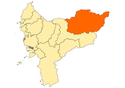
West Kalimantan is a province of Indonesia. It is one of five Indonesian provinces comprising Kalimantan, the Indonesian part of the island of Borneo. Its capital and largest city is Pontianak. It is bordered by East Kalimantan and Central Kalimantan to the east, the Malaysian state of Sarawak to the north, and the Indian Ocean to the west and the Java Sea to the south. The province has an area of 147,307 km2, and had a population of 4,395,983 at the 2010 Census and 5,414,390 at the 2020 Census; the official estimate as at mid 2022 was 5,541,376. Ethnic groups include the Dayak, Malay, Chinese, Javanese, Bugis, and Madurese. The borders of West Kalimantan roughly trace the mountain ranges surrounding the vast watershed of the Kapuas River, which drains most of the province. The province shares land borders with Central Kalimantan to the southeast, East Kalimantan to the east, and the Malaysian territory of Sarawak to the north.

<span class="mw-page-title-main">South Hulu Sungai Regency</span> Regency in South Kalimantan, Indonesia

South Hulu Sungai Regency is one of the regencies (kabupaten) in South Kalimantan province, Indonesia. It had an area of 1,804.94 km2, and a population of 212,485 at the 2010 Census and 228,006 at the 2020 Census; the official estimate as at mid 2022 was 232,212. The capital of the regency is the town of Kandangan, which is famous for its culinary ketupat Kandangan.

<span class="mw-page-title-main">Kotabaru Regency</span> Regency of Indonesia

Kotabaru Regency is one of the eleven regencies in the Indonesian province of South Kalimantan. It consists of two parts; the smaller but more populated part comprises Laut Island, the largest island off the coast of Kalimantan, together with the smaller Sebuku Island off Laut Island's east coast and even smaller islands nearby; the larger but less populated part consists of districts on the mainland of Kalimantan. The regency as a whole has an area of 9,480.17 km2, and had a population of 290,142 at the 2010 Census and 325,622 at the 2020 Census. The official estimate as at mid 2022 was 334,158, of whom 178,660 were in the insular part and 155,498 in the mainland part of the regency. The regency seat is located at the large town of Kotabaru at the northern tip of Laut Island.

<span class="mw-page-title-main">Sanggau Regency</span> Regency of Indonesia

Sanggau Regency is a regency in the north-central section of West Kalimantan province of Indonesia. On 18 December 2003, the regency's eastern portion was split off to create a new regency called Sekadau, leaving Sanggau with an area of 12,857.8 km2 (5,000 sq mi). As of the 2020 census, Sanggau Regency had a population of 484,836; the official estimate as at mid 2022 was 492,989. Alongside the Landak, Sekadau, and Sintang regencies, it is one of four West Kalimantan regencies with a predominantly Catholic populations.

<span class="mw-page-title-main">North Central Timor Regency</span> Regency of Indonesia

North Central Timor Regency is a regency in East Nusa Tenggara Province, Indonesia. It covers an area of 2,669.70 km2, and had a population of 229,803 at the 2010 Census and 259,829 at the 2020 Census; the official estimate as at mid 2022 was 268,067. Its regency seat is located at the town of Kefamenanu, which had a population of 49,095 in mid 2022. The regency borders Timor Leste's Oecusse enclave, one of few Indonesian regions that have a land border with other countries.

<span class="mw-page-title-main">Paser Regency</span> Regency in Kalimantan, Indonesia

Paser Regency is a Regency (kabupaten) within East Kalimantan province in Indonesia, it is the southernmost regency of the East Kalimantan province. Its administrative centre is Tana Paser. It covers an area of 7,730 km2, and it had a population of 230,316 at the 2010 Census and 275,452 at the 2020 Census; the official estimate as at mid 2022 was 280,065 . Before 2007, this regency was formerly named Pasir Regency.

<span class="mw-page-title-main">Penajam North Paser Regency</span> Regency in East Kalimantan, Indonesia

Penajam North Paser Regency is a regency in the Indonesian province of East Kalimantan. Its administrative centre is the town of Penajam. The area which now forms Penajam North Paser was part of Paser Regency until its creation as a separate regency on 10 April 2002. It covers an area of 3,333.06 km2 and it had 142,922 inhabitants at the 2010 census and 178,681 at the 2020 census; the official estimate as at mid 2022 was 183,043. Penajam North Paser Regency has the smallest area among the seven regencies in East Kalimantan province.

<span class="mw-page-title-main">Gunung Mas Regency</span> Regency in Indonesia

Gunung Mas Regency is one of the thirteen regencies of Central Kalimantan Province, Indonesia. The regency seat is located at the town of Kuala Kurun in Kurun District. The population of Gunung Mas Regency was 96,900 at the 2010 census ; and 135,373 at the 2020 census; the official estimate as at mid 2022 was 142,309.

<span class="mw-page-title-main">Katingan Regency</span> Regency in Kalimantan, Indonesia

Katingan Regency is one of the thirteen regencies which comprise the Central Kalimantan Province on the island of Kalimantan (Borneo), Indonesia. It was created on 10 April 2002 from what were previously the eastern districts of East Kotawaringin Regency. The town of Kasongan is the capital of the Regency, which covers an area of 17,500 km2. The population of Katingan Regency was 146,439 at the 2010 Census and 162,222 at the 2020 Census; the official estimate as at mid 2022 was 163,989.

<span class="mw-page-title-main">Seruyan Regency</span> Regency in Kalimantan, Indonesia

Seruyan Regency is one of the thirteen regencies which comprise the Central Kalimantan Province on the island of Kalimantan (Borneo), Indonesia. It was created on 10 April 2002 from what were previously the western districts of East Kotawaringin Regency. The town of Kuala Pembuang in Seruyan Hilir District is the capital of Seruyan Regency. The population of the Regency was 139,931 at the 2010 Census and 162,906 at the 2020 census; the official estimate was at mid 2022 was 166,072.

<span class="mw-page-title-main">Malinau Regency</span> Regency in North Kalimantan, Indonesia

Malinau Regency is a regency of North Kalimantan Province in Indonesia. It was created on 4 October 1999 from the western districts of Bulungan Regency. The administrative centre is the town of Malinau. The regency is home to the Kayan Mentarang National Park. It covers an area of 38,973.56 km2, and had a population of 62,423 at the 2010 Census and 82,510 at the 2020 Census; the official estimate as at mid 2022 was 85,316. It is the regency with the largest area in the province, as well as the least densely populated. Other than that, Malinau is the only regency in North Kalimantan that is predominantly Protestant and the second most-developed region in North Kalimantan after Tarakan in terms of Human Development Index.

<span class="mw-page-title-main">Tana Tidung Regency</span> Regency of Indonesia

Tana Tidung Regency is a regency within the Indonesian province of North Kalimantan. It is Indonesia's least populous regency, with 25,584 inhabitants recorded in the 2020 census; the official estimate as at mid 2022 was 27,571. Its regency seat is the town of Tideng Pale, in Sesayap District, where 11,280 of the regency's population lived in mid 2022.

<span class="mw-page-title-main">Mempawah Regency</span> Regency in West Kalimantan, Indonesia

Mempawah Regency is a regency of West Kalimantan Province of Indonesia. Originally including a wider area of West Kalimantan, this Pontianak Regency was reduced on 4 October 1999 by the north-eastern districts being removed to form a new Landak Regency, and was further reduced on 17 July 2007 by its southern districts cut out to create a new Kubu Raya Regency. Since 2007 it covers 2,797.88 km2, and had a population of 234,021 at the 2010 Census and 301,560 at the 2020 Census; the official estimate as at mid 2022 was 310,927. The principal town lies at Mempawah.

<span class="mw-page-title-main">Melawi Regency</span> Regency in West Kalimantan, Indonesia

Melawi Regency is a regency of West Kalimantan province of Indonesia. It was created on 18 December 2003 from part of Sintang Regency. It covers an area of 10,640.8 km2, and had a population of 178,645 at the 2010 Census and 228,270 at the 2020 Census; the official estimate as at mid 2022 was 235,025. The principal town lies at Nanga Pinoh.

<span class="mw-page-title-main">Sekadau Regency</span> Regency in West Kalimantan, Indonesia

Sekadau Regency is a regency of West Kalimantan province of Indonesia. It was created on 18 December 2003 from the eastern part of Sanggau Regency. It covers an area of 6,275.39 km2, and had a population of 181,634 at the 2010 Census and 211,559 at the 2020 Census; the official estimate as at mid 2022 was 214,429. The regency seat lies at the town of Sekadau in Sekadau Hilir District.

<span class="mw-page-title-main">Sintang Regency</span> Regency of Indonesia

Sintang Regency is a regency of West Kalimantan province of Indonesia. It covers an area of 21,638.2 km2, and had a population of 364,759 at the 2010 Census and 421,306 at the 2020 Census; the official estimate as at mid 2022 was 426,416. It is one of the few Indonesian regencies having a land border with other countries. It is also the second largest regency in the province by land area after Landak Regency. The regency was formerly the site of the Sintang Kingdom, a Hindu kingdom that later converted to Islam and which was a regional power in the interior of Borneo Island. The regency seat is located at the large town of Sintang, which is among the biggest settlements in Borneo's interior alongside Putussibau and Puruk Cahu.

<span class="mw-page-title-main">Putussibau</span> Town in West Kalimantan, Indonesia

Putussibau is an Indonesian town in Kapuas Hulu Regency, West Kalimantan. It sits on the river Kapuas, with the main part of the town located on the right banks, or north, of the river. Officially an administrative village within North Putussibau District, the urban settlement sprawls outside of the primary boundaries to the opposite bank of the river. Official estimates from Statistics Indonesia places the population of the town proper at 12,459 in 2015.

The Dayak Desa War or Majang Desa War was an armed uprising by the Dayak Desa tribe, and later Indonesian nationalists, in West Kalimantan against the Japanese Empire and the Dutch East Indies during World War II. The war was initially caused by the local population's opposition against the rōmusha system and disappointment with Japanese occupation. In the initial phase of Japanese occupation, several Japanese companies entered the region to gain natural resources in order to support the Japanese war effort in the Pacific. Occupying Japanese forced locals to work for free for these companies, mainly in coal mining and timber production. After that, a Japanese foreman working in a company wanted to marry the daughter of Pang Linggan, a respected Dayak chief in the region, which caused more tension between locals and the Japanese. Dayak tribes in the region initiated mangkuk merah ritual, as a sign to mobilise men from villages and prepare for war. The Japanese were driven out of the Borneo interior in June 1945, but returned on 17 July and continued until 31 August 1945 when Japanese forces there surrendered and left the region, replaced by Allied forces including the Dutch, who would later be opposed again until recognition of Indonesian independence in 1949.

<span class="mw-page-title-main">Bonar Sianturi</span> Indonesian military officer (1944–2022)

Bonar Sianturi was an Indonesian military officer who served as the Regent of Sintang in West Kalimantan from 1989 to 1994. Previously, he served as the commander of the Sanggau Military District from 1986 until 1989.

References

  1. 1 2 Badan Pusat Statistik, Jakarta, 2023, Kabupaten Kapuas Hulu Dalam Angka 2023 (Katalog-BPS 1102001.6106)
  2. "Badan Pusat Statistik".
  3. 1 2 3 "Profil Kab Kapuas Hulu" (PDF).{{cite web}}: CS1 maint: url-status (link)
  4. 1 2 Biro Pusat Statistik, Jakarta, 2011.
  5. 1 2 3 4 5 6 7 8 9 10 Badan Pusat Statistik, Jakarta, 2021.
  6. "Sosial-Ekonomi Danau Sentarum" (PDF).{{cite web}}: CS1 maint: url-status (link)
  7. 1 2 3 "Sejarah Kabupaten Kapuas Hulu" [History of Kapuas Hulu Regency]. Kabupaten Kapuas Hulu (in Indonesian). Retrieved 2021-11-15.
  8. 1 2 "Era Jepang, 1.000 Romusha dan Jugun Ianfu Tewas di Kapuas Hulu". IndependensI. Retrieved 2021-06-24.
  9. "Perang Dayak Desa dan Tewasnya Perwira Senior Jepang". SINDOnews.com (in Indonesian). 2016-12-31. Retrieved 2021-06-24.
  10. S13; S13 (2017-08-16). "Pang Suma: Pejuang dari Dayak". PinterPolitik.com (in Indonesian). Retrieved 2021-06-24.
  11. "Tapak Tilas Perjuangan Pahlawan Pangsuma asal Kalbar Melawan Penjajah". kumparan (in Indonesian). Retrieved 2021-06-24.
  12. "Pemekaran Kapuas Raya Tunggu Putusan Final" . Retrieved 2021-06-24.
  13. antaranews.com (2021-03-01). "DPD RI harapkan Provinsi Kapuas Raya segera terwujud". Antara News. Retrieved 2021-06-24.
  14. antaranews.com (2020-12-07). "Moratorium pemekaran daerah di tengah pandemi". Antara News. Retrieved 2021-06-24.
  15. Badan Pusat Statistik, Jakarta, 2022.
  16. "PP No. 17 Tahun 2018 tentang Kecamatan [JDIH BPK RI]". peraturan.bpk.go.id. Retrieved 2021-04-16.
  17. "UU 22 1999" (PDF).{{cite web}}: CS1 maint: url-status (link)
  18. "Indonesia Regencies". www.statoids.com. Retrieved 2021-05-27.
  19. "Keputusan KPU Nomor 283/PL.01.3-Kpt/06/KPU/IV/2018 tentang Penetapan Daerah Pemilihan dan Alokasi Kursi Anggota Dewan Perwakilan Rakyat Daerah Provinsi dan Dewan Perwakilan Rakyat Daerah Kabupaten/Kota di Wilayah Provinsi Kalimantan Barat dalam Pemilihan Umum Tahun 2019" (PDF). KPU RI. 4 April 2018. Retrieved 18 January 2021.
  20. "BPS Kabupaten Kapuas Hulu". kapuashulukab.bps.go.id. Retrieved 2021-06-24.
  21. "Penerimaan Mahasiswa Baru STIT Iqra' Kapuas Hulu – Info Kapuas Hulu" . Retrieved 2021-06-24.
  22. PONTIANAK, POLITEKNIK NEGERI. "BUPATI HADIRI PKKMB PDD POLNEP KAPUAS HULU". BUPATI HADIRI PKKMB PDD POLNEP KAPUAS HULU (in Indonesian). Retrieved 2021-06-24.
  23. Diskominfotik. "Bupati Kapuas Hulu Tinjau RSUD Putussibau". Bupati Kapuas Hulu Tinjau RSUD Putussibau (in Indonesian). Retrieved 2021-06-24.
  24. "Informasi SDM Kesehatan Nasional". bppsdmk.kemkes.go.id. Retrieved 2021-06-24.
  25. "Gubernur Kalbar Resmikan RS Pratama Semitau". www.dinkes.kapuashulukab.go.id. Retrieved 2021-06-24.
  26. "Rumah Sakit RS Bergerak Badau Kapuas Hulu". Goalkes. Retrieved 2021-06-24.
  27. "RS Bergerak Badau Terus Tingkatkan Pelayanan Kepada Warga Perbatasan – Info Kapuas Hulu" . Retrieved 2021-06-24.
  28. "Wings Air buka rute Putussibau Pontianak Sintang".{{cite web}}: CS1 maint: url-status (link)
  29. "Manunggal Air Terbang ke Sintang, Ketapang, Putussibau". Tribun Pontianak (in Indonesian). Retrieved 2021-06-24.
  30. "TRIBUNWIKI: Ini Jadwal Trayek Bus DAMRI Putussibau-Pontianak". Tribun Pontianak (in Indonesian). Retrieved 2021-06-24.
  31. "Di Putussibau Sudah Ada Ojek Online, Ini Aplikasinya". Tribun Pontianak (in Indonesian). Retrieved 2021-06-24.

0°49′00″N112°46′00″E / 0.8167°N 112.7667°E / 0.8167; 112.7667