Prairie Mountain is a 5,678-foot-elevation mountain summit near the western edge of the North Cascades, in Snohomish County of Washington state. It is located six miles east of Darrington, Washington, and northwest of Glacier Peak which is one of the Cascade stratovolcanoes. It is situated on land administered by the Mount Baker-Snoqualmie National Forest. The nearest higher peak is White Chuck Mountain, 4.7 miles (7.6 km) to the south-southeast. Precipitation runoff from Prairie Mountain drains into the Sauk River and Suiattle River, both tributaries of the Skagit River. The mountain was so named because of the beautiful prairie at its base.

Mount Misch is a remote 7,435 ft mountain summit in the North Cascades, in Skagit County of Washington state. It is the highest point of the Buckindy Range, or Buckindy Ridge. It is located 19 miles east-northeast of Darrington, Washington, and 15 miles north-northwest of Glacier Peak which is one of the Cascade stratovolcanoes. It is situated in the Glacier Peak Wilderness on land administered by the Mount Baker-Snoqualmie National Forest. Mount Misch was named by mountaineer and author Fred Beckey for his friend Peter Misch (1909-1987), University of Washington geology professor and mountaineer, who was renowned for his study of the North Cascades. Precipitation runoff from Mount Misch and the unnamed Goat Creek glacier on its east slope drains into tributaries of the Suiattle River and ultimately the Skagit River.

Hurry-up Peak is a 7,821-foot-elevation summit located on the shared boundary of Skagit County and Chelan County in Washington state. It is positioned on the crest of the North Cascades Range, and is set at the northern end of the Ptarmigan Traverse. Hurry-up Peak is situated southeast of Cascade Pass on the shared border of North Cascades National Park and Glacier Peak Wilderness. The nearest higher peak is Spider Mountain, 1.49 miles (2.40 km) to the south, with Magic Mountain 0.83 miles (1.34 km) to the north, and Trapper Mountain 0.7 miles (1.1 km) to the east. The S Glacier rests on the eastern flank of the peak and meltwater from it drains into Trapper Lake. Precipitation runoff on the east side the mountain drains into tributaries of the Stehekin River, while precipitation drains into the Cascade River from the west side. Ess Mountain and S Mountain are variant names for Hurry-up Peak. This geographical feature's toponym was officially adopted in 1969 by the U.S. Board on Geographic Names.

Mount Chaval is a craggy 7,127-foot (2,172-metre) mountain summit located in Skagit County of Washington state. Situated within the Glacier Peak Wilderness, Mount Chaval is positioned west of the crest of the North Cascades Range, approximately 15 miles northeast of the town of Darrington. It has two subsidiary peaks, East Peak and Middle Peak, each 7040 ft. The nearest higher neighbor is Snowking Mountain, 2.51 miles (4.04 km) to the northeast. Precipitation runoff from Mount Chaval drains into tributaries of the Skagit River.

Snowking Mountain is a 7,433-foot (2,266-metre) summit located in Skagit County of Washington state. Situated within the Glacier Peak Wilderness, Snowking Mountain is positioned west of the crest of the North Cascades, approximately 18 miles northeast of the town of Darrington. It is set within the Glacier Peak Wilderness, on land managed by Mount Baker–Snoqualmie National Forest. Snowking has two subsidiary peaks, West Peak (7,425 ft), and Middle Peak (7,400 ft). A broad unnamed glacier known colloquially as Snowking Glacier rests on the north face. Downslope of that glacier are Snowking Lake, Found Lake, and Cyclone Lake. Mount Tommy Thompson is three miles to the northwest, and the nearest higher neighbor is Mount Misch, 5.75 miles (9.25 km) to the southeast. Precipitation runoff from Snowking Mountain drains into tributaries of the Skagit River.

Sitting Bull Mountain is a 7,759-foot (2,365-metre) double summit mountain in the North Cascades of Washington state. The north summit is higher than the south peak, and easier to climb, however neither peak sees much climbing activity. Sitting Bull Mountain is located 2.1 mi (3.4 km) northwest of Suiattle Pass in the heart of the Glacier Peak Wilderness. Its nearest higher peak is Plummer Mountain, 1.51 mi (2.43 km) to the south-southwest. The mountain is situated on the crest of the Cascade Range, on the shared border of Snohomish County and Chelan County. Precipitation runoff from Sitting Bull Mountain drains east into Agnes Creek which is a tributary of the Stehekin River, or west into Canyon Creek which is a tributary of the Suiattle River.

Indian Head Peak is a prominent 7,448-foot (2,270-metre) mountain summit located in the Glacier Peak Wilderness, in the North Cascades of Washington state. The mountain is situated in Chelan County, on land managed by the Okanogan–Wenatchee National Forest. Its nearest higher neighbor is Kololo Peaks, 3.29 mi (5.29 km) to the north. Indian Head Peak is the second-highest point on Wenatchee Ridge, a subrange which also includes Mount Saul, Whittier Peak, and Mount David. Precipitation runoff from the peak drains into Indian Creek and White River which are tributaries of the Wenatchee River.

White Mountain is a 7,043-foot (2,147-metre) mountain located in the Glacier Peak Wilderness of the North Cascades in Washington state. The mountain is situated on the crest of the Cascade Range, on the shared border of Snohomish County and Chelan County, and also straddling the boundary between Mount Baker-Snoqualmie National Forest and Wenatchee National Forest. White Mountain is located 3.04 mi (4.89 km) to the west-southwest of Kololo Peaks, and immediately north of White Pass. The Pacific Crest Trail traverses the south slope of the peak. Precipitation runoff from the peak drains into the White River, White Chuck River, and Sauk River. The mountain's name was suggested by The Mountaineers, and officially adopted in 1918 by the United States Board on Geographic Names.

Johnson Mountain is a 6,721-foot (2,049-metre) mountain summit located in the Glacier Peak Wilderness of the North Cascades in Washington state. The mountain is situated in eastern Snohomish County, in the Mt. Baker-Snoqualmie National Forest. Its nearest higher peak is White Mountain, 3.3 mi (5.3 km) to the northeast, along with Indian Head Peak 3.38 mi (5.44 km) to the east. Precipitation runoff from the mountain drains into tributaries of the Sauk River. The mountain's name honors Mackinaw Johnson, a prospector who had a cabin in the vicinity.

Napeequa Peak is an 8,073-foot (2,461-metre) pyramidal mountain summit located in the Glacier Peak Wilderness of the North Cascades in Washington state. The mountain is situated on the crest of the Cascade Range, on the shared border of Snohomish County and Chelan County, also straddling the boundary between the Mount Baker-Snoqualmie National Forest and the Wenatchee National Forest. Its nearest neighbor is Cirque Mountain, 0.3 mi (0.48 km) to the north, and the nearest higher peak is Buck Mountain, 2.56 mi (4.12 km) to the east-southeast. Precipitation runoff from the peak drains east to the headwaters of Napeequa River; or west into the Suiattle River. The mountain's name is taken from the river's name, which was applied by Albert Hale Sylvester (1871-1944), a pioneer surveyor, explorer, topographer, and forest supervisor in the Cascades.

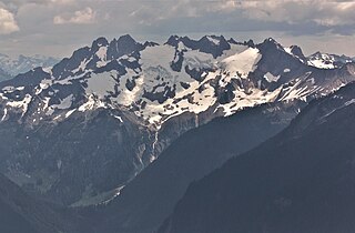
Brahma Peak is a remote 8,078-foot (2,462-metre) mountain summit located on Chiwawa Ridge in the North Cascades, in Chelan County of Washington state. The mountain is situated in the Glacier Peak Wilderness, on land managed by the Wenatchee National Forest. Its nearest higher neighbor is Buck Mountain, 1.8 mi (2.9 km) to the north. Brahma and Buck are set on Chiwawa Ridge, and other notable peaks on this ridge include Fortress Mountain, Cirque Mountain, Napeequa Peak, Mount Berge, Bandit Peak, and Chiwawa Mountain. Precipitation runoff from Brahma and meltwater from its glacier remnants drains into Chiwawa River and Napeequa River, both tributaries of the Wenatchee River. Topographic relief is significant since the southwest lavender-colored schist cliffs of this peak rise nearly 4,000 feet above the Napeequa River Valley in approximately one mile.

Cirque Mountain is a 7,966-foot (2,428-metre) mountain summit located in the Glacier Peak Wilderness of the North Cascades in Washington state. The mountain is situated on the crest of the Cascade Range, on the shared border of Snohomish County and Chelan County, also straddling the boundary between the Mount Baker-Snoqualmie National Forest and the Wenatchee National Forest. Its nearest higher peak is Napeequa Peak, 0.3 mi (0.48 km) to the south. The peak is set on Chiwawa Ridge with Napeequa, and other notable peaks on this ridge include Fortress Mountain, Buck Mountain, Brahma Peak, Mount Berge, and Chiwawa Mountain. Topographic relief is significant since the western aspect of the mountain rises 4,000 feet above the Suiattle Valley in approximately 1.5 mi (2.4 km). This mountain has small, unnamed, hanging glaciers in cirques surrounding the summit. Precipitation runoff from the peak and meltwater from the glaciers drains east to the headwaters of Napeequa River; or west into the Suiattle River.

Tenpeak Mountain is an 8,312-foot (2,533-metre) mountain summit located in the Glacier Peak Wilderness of the North Cascades in Washington state. Tenpeak is situated on the crest of the Cascade Range, on the shared border of Snohomish County and Chelan County, also straddling the boundary between the Mount Baker-Snoqualmie National Forest and the Wenatchee National Forest. Its nearest higher neighbor is Luahna Peak, 2.5 mi (4.0 km) to the southeast. Topographic relief is significant since the northern aspect of the mountain rises 4,200 feet above the Suiattle Valley in approximately 1.5 mi (2.4 km). This mountain has small, unnamed, hanging glaciers in cirques surrounding the summit, and the terminus of the Honeycomb Glacier lies below the western base of the mountain. Precipitation runoff from the mountain and meltwater from the glaciers drains south into White River; or north into the Suiattle River. This mountain's descriptive name was suggested by The Mountaineers, and was officially adopted in 1918 by the U.S. Board on Geographic Names. The first ascent was made September 21, 1940, by Lloyd Anderson and Tom Campbell.

Mount Berge is a 7,951-foot (2,423-metre) double-summit granitic mountain located in the Glacier Peak Wilderness of the North Cascades, in Chelan County of Washington state. The mountain is situated along the crest of the Cascade Range, on land managed by the Okanogan–Wenatchee National Forest. Its nearest higher neighbor is Napeequa Peak, 1.2 mi (1.9 km) to the west, and Buck Mountain is 1.7 mi (2.7 km) to the east-southeast. Berge is positioned on Chiwawa Ridge with Buck and Napeequa, and other notable peaks on this ridge include Fortress Mountain, Brahma Peak, Cirque Mountain, Helmet Butte, and Chiwawa Mountain. Precipitation runoff from Berge drains to the headwaters of Napeequa River; or east into tributaries of the Chiwawa River.

Ice Box is an 8,112-foot (2,473-metre) mountain summit located in the Entiat Mountains, a sub-range of the North Cascades, in Chelan County of Washington state. Ice Box ranks as ninth-highest in the Entiat Mountains, and 147th of Washington's highest 200 peaks. Its nearest higher neighbor is Mount Maude, 1.8 miles (2.9 km) to the north, Spectacle Buttes are set 1.9 miles (3.1 km) to the northeast, and Chilly Peak is 1.3 miles (2.1 km) to the southeast. Ice Box is situated 1.25 miles (2.01 km) south of Ice Lakes in the Okanogan-Wenatchee National Forest. Precipitation runoff from the mountain drains east into Ice Creek, or west into Box Creek. This peak is positioned between these two creeks, hence its name.

Chilly Peak is a 7,970-foot (2,429-metre) mountain summit located in the Entiat Mountains, a sub-range of the North Cascades, in Chelan County of Washington state. It ranks as 194th of Washington's highest 200 peaks. The nearest higher neighbor is Ice Box, 1.3 miles (2.1 km) to the northwest, and Spectacle Buttes are set 2.1 miles (3.4 km) to the north-northeast. Chilly Peak is situated 2.5 miles (4.0 km) south of Ice Lakes in the Okanogan–Wenatchee National Forest. Precipitation runoff from the mountain drains east into Ice Creek which is a tributary of the Entiat River, and west into Rock Creek, a tributary of the Chiwawa River.

Jove Peak is a 6,007 ft (1,830 m) mountain summit located 5 mi (8.0 km) north of Stevens Pass on the common border of Snohomish County with Chelan County in Washington state. This peak is situated 12 mi (19 km) west of Lake Wenatchee, in the Henry M. Jackson Wilderness, on land managed by Mount Baker-Snoqualmie National Forest and Okanogan-Wenatchee National Forest. Jove Peak was named by Albert Hale Sylvester for Jove in association with the mythology-theme of nearby Minotaur and Theseus Lakes which are near Labyrinth Mountain, 2.5 mi (4.0 km) to the northeast. Precipitation runoff from the peak drains west into headwaters of Rapid River, or east into Rainy Creek which is a tributary of the Little Wenatchee River.

Black Mountain is a 7,262-foot-elevation (2,213-meter) summit located in the North Cascades, in Snohomish County of Washington state. The mountain is situated in the Glacier Peak Wilderness on land managed by Mount Baker-Snoqualmie National Forest. Neighbors include line parent Kololo Peaks, 6 mi (9.7 km) to the east, Painted Mountain two miles west, and Glacier Peak is 5 mi (8.0 km) to the northeast. Precipitation runoff from the peak drains west into tributaries of the North Fork Sauk River, and east into the White Chuck River. Topographic relief is significant as the summit rises 3,460 feet above the White Chuck in two miles. The first ascent of the summit was likely made in 1897 by a survey team including A. H. Dubor, Thomas G. Gerdine, and Sam Strom, who named the mountain for the dark color of its rock. The ascent from the north via Lake Byrne is non-technical.
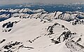
Mount Buckindy is a remote 7,320-foot-elevation (2,230-meter) mountain summit located in the North Cascades, in Skagit County of Washington state. It is the second-highest point of the Buckindy Range, or Buckindy Ridge. It is set in the Glacier Peak Wilderness on land managed by the Mount Baker-Snoqualmie National Forest. It is situated 20 miles east-northeast of Darrington, Washington, and 17 miles north-northwest of Glacier Peak which is one of the Cascade stratovolcanoes. Precipitation runoff from Mount Buckindy drains south to the Suiattle River via Buck Creek and Downey Creek, and north to the Cascade River via Kindy Creek. Topographic relief is significant as the summit rises 4,700 feet above Kindy Creek in less than two miles. The mountain's toponym is a portmanteau of Buck and Kindy Creeks, and has been officially adopted by the United States Board on Geographic Names.

Helmet Butte is a 7,400-foot (2,256-metre) summit located in the Glacier Peak Wilderness of the North Cascades in Washington state.