
Whatcom Peak is in North Cascades National Park in the U.S. state of Washington. Whatcom Peak is .50 mi (0.80 km) north of Challenger Glacier and the Whatcom Glacier descends from the northeast slopes of the peak. An unnamed hanging glacier descends along the northwest flank of the peak. This mountain is set between Mount Challenger and Easy Peak.

Sentinel Peak is a 8,266-foot (2,519-metre) mountain located in the Glacier Peak Wilderness of Washington's North Cascades. The summit is part of the Ptarmigan Traverse. The mountain is situated on the crest of the Cascade Range, on the shared border of Snohomish County and Chelan County, also straddling the boundary between the Mount Baker-Snoqualmie National Forest and the Wenatchee National Forest. The South Cascade Glacier lies below its western slope, and the LeConte Glacier lies on the northeast slope. Its nearest higher peak is Spire Point, 3.03 mi (4.88 km) to the south-southwest.
Breccia Peak is a mountain summit in the North Cascades, in Snohomish County of Washington state. Its summit is 6,487 feet (1,977 m) above sea level. The peak is the eroded remnant of a stratovolcano, and takes its name from the type of rock, breccia, that it is composed of. It is located 15 miles southeast of Darrington, Washington, and 8.7 miles (14.0 km) west of Glacier Peak, which is one of the Cascade stratovolcanoes. It is situated in the Glacier Peak Wilderness on land administered by the Mount Baker-Snoqualmie National Forest. The nearest higher peak is Mount Pugh, 3.5 miles (5.6 km) to the northwest. Precipitation runoff from Breccia Peak drains into tributaries of the Sauk River.

White Chuck Mountain, or native name Hi Khaed, is a 6,989 ft (2,130 m) summit near the western edge of the North Cascades, in Snohomish County of Washington state. It is located southeast of Darrington, Washington, east of the Mountain Loop Highway, and northwest of Glacier Peak which is one of the Cascade stratovolcanoes. It is situated at the confluence of the White Chuck River and the Sauk River on land administered by the Mount Baker-Snoqualmie National Forest. The mountain is named for the White Chuck River, which "chuck" in Chinook Jargon means "water". The nearest higher neighbor is Mount Pugh, 4.9 miles (7.9 km) to the south-southeast.

Devils Thumb is a mountain summit near the western edge of the North Cascades, in Snohomish County of Washington state. It is located 10 miles south of Darrington, Washington and west of Glacier Peak which is one of the Cascade stratovolcanoes. It is situated on land administered by the Mount Baker-Snoqualmie National Forest. The nearest higher peak is Devils Peak, 0.79 miles (1.27 km) to the southwest. Precipitation runoff from Devils Thumb drains into tributaries of the Sauk River.

Indian Head Peak is a prominent 7,448-foot (2,270-metre) mountain summit located in the Glacier Peak Wilderness, in the North Cascades of Washington state. The mountain is situated in Chelan County, on land managed by the Okanogan–Wenatchee National Forest. Its nearest higher neighbor is Kololo Peaks, 3.29 mi (5.29 km) to the north. Indian Head Peak is the second-highest point on Wenatchee Ridge, a subrange which also includes Mount Saul, Whittier Peak, and Mount David. Precipitation runoff from the peak drains into Indian Creek and White River which are tributaries of the Wenatchee River.
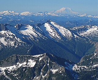
Kololo Peaks is an 8,200+ ft mountain located in the Glacier Peak Wilderness of the North Cascades in Washington state. The mountain is situated on the crest of the Cascade Range, on the shared border of Snohomish County and Chelan County, and also straddling the boundary between Mount Baker-Snoqualmie National Forest and Wenatchee National Forest. The nearest higher peak is Glacier Peak, 3.29 mi (5.29 km) to the north. Precipitation runoff and meltwater from the White River Glacier on the southeast slope drains into White River. On the west slope, the White Chuck Glacier drains into the White Chuck River, and the Suiattle Glacier and Honeycomb Glacier on the north and east sides drain into the Suiattle River. Surrounded by these glaciers, Fred Beckey in his Cascade Alpine Guide describes the mountain as being almost a nunatak.
Whittier Peak is a 7,281-foot (2,219-metre) mountain summit located in the Glacier Peak Wilderness of the North Cascades in Washington state. The mountain is situated in Chelan County, in the Wenatchee National Forest. Its nearest higher neighbor is Mount David, 2.26 mi (3.64 km) to the northeast, and Indian Head Peak is 5.2 mi (8.4 km) to the northwest. Precipitation runoff from Whittier Peak drains into tributaries of the Wenatchee River. The peak was named for poet John Greenleaf Whittier by Albert Hale Sylvester, a pioneer surveyor, explorer, topographer, and forest supervisor in the Cascades who named thousands of natural features. Other peaks in the immediate vicinity named by Sylvester after poets include Irving Peak, Poe Mountain, Longfellow Mountain, and Bryant Peak.

Johnson Mountain is a 6,721-foot (2,049-metre) mountain summit located in the Glacier Peak Wilderness of the North Cascades in Washington state. The mountain is situated in eastern Snohomish County, in the Mt. Baker-Snoqualmie National Forest. Its nearest higher peak is White Mountain, 3.3 mi (5.3 km) to the northeast, along with Indian Head Peak 3.38 mi (5.44 km) to the east. Precipitation runoff from the mountain drains into tributaries of the Sauk River. The mountain's name honors Mackinaw Johnson, a prospector who had a cabin in the vicinity.
Hagan Mountain is a multi-peak mountain located in Whatcom County, Washington state, within North Cascades National Park. It has an elevation of 7,080-feet (2,160-metres). The mountain is situated approximately 12 mi (19 km) north of Marblemount.

Napeequa Peak is an 8,073-foot (2,461-metre) pyramidal mountain summit located in the Glacier Peak Wilderness of the North Cascades in Washington state. The mountain is situated on the crest of the Cascade Range, on the shared border of Snohomish County and Chelan County, also straddling the boundary between the Mount Baker-Snoqualmie National Forest and the Wenatchee National Forest. Its nearest neighbor is Cirque Mountain, 0.3 mi (0.48 km) to the north, and the nearest higher peak is Buck Mountain, 2.56 mi (4.12 km) to the east-southeast. Precipitation runoff from the peak drains east to the headwaters of Napeequa River; or west into the Suiattle River. The mountain's name is taken from the river's name, which was applied by Albert Hale Sylvester (1871-1944), a pioneer surveyor, explorer, topographer, and forest supervisor in the Cascades.
Mount Forgotten is a 6,005-foot-elevation (1,830-meter) mountain summit near the western edge of the North Cascades, in Snohomish County of Washington state. It is located five miles north of Barlow Pass along the Mountain Loop Highway near the Monte Cristo area and is situated on land administered by the Mount Baker-Snoqualmie National Forest. The nearest higher peak is Mount Pugh, 4.22 mi (6.79 km) to the northeast. Precipitation runoff from the mountain drains into tributaries of the Sauk River.

Brahma Peak is a remote 8,078-foot (2,462-metre) mountain summit located on Chiwawa Ridge in the North Cascades, in Chelan County of Washington state. The mountain is situated in the Glacier Peak Wilderness, on land managed by the Wenatchee National Forest. Its nearest higher neighbor is Buck Mountain, 1.8 mi (2.9 km) to the north. Brahma and Buck are set on Chiwawa Ridge, and other notable peaks on this ridge include Fortress Mountain, Cirque Mountain, Napeequa Peak, Mount Berge, Bandit Peak, and Chiwawa Mountain. Precipitation runoff from Brahma and meltwater from its glacier remnants drains into Chiwawa River and Napeequa River, both tributaries of the Wenatchee River. Topographic relief is significant since the southwest lavender-colored schist cliffs of this peak rise nearly 4,000 feet above the Napeequa River Valley in approximately one mile.

Cirque Mountain is a 7,966-foot (2,428-metre) mountain summit located in the Glacier Peak Wilderness of the North Cascades in Washington state. The mountain is situated on the crest of the Cascade Range, on the shared border of Snohomish County and Chelan County, also straddling the boundary between the Mount Baker-Snoqualmie National Forest and the Wenatchee National Forest. Its nearest higher peak is Napeequa Peak, 0.3 mi (0.48 km) to the south. The peak is set on Chiwawa Ridge with Napeequa, and other notable peaks on this ridge include Fortress Mountain, Buck Mountain, Brahma Peak, Mount Berge, and Chiwawa Mountain. Topographic relief is significant since the western aspect of the mountain rises 4,000 feet above the Suiattle Valley in approximately 1.5 mi (2.4 km). This mountain has small, unnamed, hanging glaciers in cirques surrounding the summit. Precipitation runoff from the peak and meltwater from the glaciers drains east to the headwaters of Napeequa River; or west into the Suiattle River.

Tenpeak Mountain is an 8,312-foot (2,533-metre) mountain summit located in the Glacier Peak Wilderness of the North Cascades in Washington state. Tenpeak is situated on the crest of the Cascade Range, on the shared border of Snohomish County and Chelan County, also straddling the boundary between the Mount Baker-Snoqualmie National Forest and the Wenatchee National Forest. Its nearest higher neighbor is Luahna Peak, 2.5 mi (4.0 km) to the southeast. Topographic relief is significant since the northern aspect of the mountain rises 4,200 feet above the Suiattle Valley in approximately 1.5 mi (2.4 km). This mountain has small, unnamed, hanging glaciers in cirques surrounding the summit, and the terminus of the Honeycomb Glacier lies below the western base of the mountain. Precipitation runoff from the mountain and meltwater from the glaciers drains south into White River; or north into the Suiattle River. This mountain's descriptive name was suggested by The Mountaineers, and was officially adopted in 1918 by the U.S. Board on Geographic Names. The first ascent was made September 21, 1940, by Lloyd Anderson and Tom Campbell.

Ice Box is an 8,112-foot (2,473-metre) mountain summit located in the Entiat Mountains, a sub-range of the North Cascades, in Chelan County of Washington state. Ice Box ranks as ninth-highest in the Entiat Mountains, and 147th of Washington's highest 200 peaks. Its nearest higher neighbor is Mount Maude, 1.8 miles (2.9 km) to the north, Spectacle Buttes are set 1.9 miles (3.1 km) to the northeast, and Chilly Peak is 1.3 miles (2.1 km) to the southeast. Ice Box is situated 1.25 miles (2.01 km) south of Ice Lakes in the Okanogan-Wenatchee National Forest. Precipitation runoff from the mountain drains east into Ice Creek, or west into Box Creek. This peak is positioned between these two creeks, hence its name.

Bandit Peak is a 7,625-foot (2,324-metre) double-summit granitic mountain located in the Glacier Peak Wilderness of the North Cascades, in Chelan County of Washington state. The mountain is situated east of the crest of the Cascade Range, on land managed by the Okanogan–Wenatchee National Forest. Its nearest higher neighbor is Brahma Peak, 5.9 mi (9.5 km) to the north. Bandit Peak is the ninth-highest peak on Chiwawa Ridge, and other notable peaks on this ridge include Mount Berge, Buck Mountain, Cirque Mountain, Napeequa Peak, Helmet Butte, and Chiwawa Mountain. Precipitation runoff from Bandit Peak drains west into Napeequa River; or east into the Chiwawa River.

Skykomish Peak is a 6,368-foot (1,941-metre) mountain summit located in the Henry M. Jackson Wilderness in the North Cascades of Washington state. The mountain is situated on the crest of the Cascade Range, on the shared border of Snohomish County with Chelan County, and also straddling the boundary between Mount Baker-Snoqualmie National Forest and Okanogan-Wenatchee National Forest. Skykomish Peak is located 15 mi (24 km) to the north of Stevens Pass, and the Pacific Crest Trail traverses the east slope of this peak. Precipitation runoff from the peak drains west into the Skykomish River, or east into Cady Creek which is a tributary of Little Wenatchee River. This mountain's name derives from its position at the head of the North Fork Skykomish River, and "Skykomish" comes from the Lushootseed word for the Skykomish people, sq̓ixʷəbš, meaning "upriver people".

Black Mountain is a 7,262-foot-elevation (2,213-meter) summit located in the North Cascades, in Snohomish County of Washington state. The mountain is situated in the Glacier Peak Wilderness on land managed by Mount Baker-Snoqualmie National Forest. Neighbors include line parent Kololo Peaks, 6 mi (9.7 km) to the east, Painted Mountain two miles west, and Glacier Peak is 5 mi (8.0 km) to the northeast. Precipitation runoff from the peak drains west into tributaries of the North Fork Sauk River, and east into the White Chuck River. Topographic relief is significant as the summit rises 3,460 feet above the White Chuck in two miles. The first ascent of the summit was likely made in 1897 by a survey team including A. H. Dubor, Thomas G. Gerdine, and Sam Strom, who named the mountain for the dark color of its rock. The ascent from the north via Lake Byrne is non-technical.

Painted Mountain is a 6,975-foot-elevation (2,126-meter) summit located in the North Cascades, in Snohomish County of Washington state. The mountain is situated in the Glacier Peak Wilderness on land managed by Mount Baker-Snoqualmie National Forest. Neighbors include line parent Black Mountain, 2.2 mi (3.5 km) to the east, and Glacier Peak is 7 mi (11 km) to the northeast. Precipitation runoff from the peak drains west into tributaries of the North Fork Sauk River. Topographic relief is significant as the summit rises nearly 5,000 feet above the river in less than two miles.


